| |||||||

| Search Forums |
| Advanced Search |
| Go to Page... |
 |
| Search this Thread |  66,194 views |
 18th April 2012, 13:27
| #1 |
| BHPian Join Date: Mar 2012 Location: Pune
Posts: 51
Thanked: 144 Times
| Mapmyindia GPS navigator VX140S review Hello folks, I had purchased a MMI GPS navigator VX140s back in July 2011. Since then, I’ve done about 9000 kms with it, mostly on highway trips. My experience with it has been mixed, slightly tilting towards the negative side. Overall it is a good product worth the price once you get the hang of the issues it has and know your way around them. It needs to be used with caution keeping an eye out for the problems it may run you into; it might ditch you and put you in risky and very risky situations. Model: VX140S, runs on Windows CE 6.0 operating system. Purchase date & price: July 30, 2011. 9800 INR. MMI software version: A4.MMI.HHC.101209 Map version: 6.0. Warranty: 6 months. Total kms used: Approx 9000 kms so far, 95% highways. Main screen:  Information presented to you on the navigation screen: 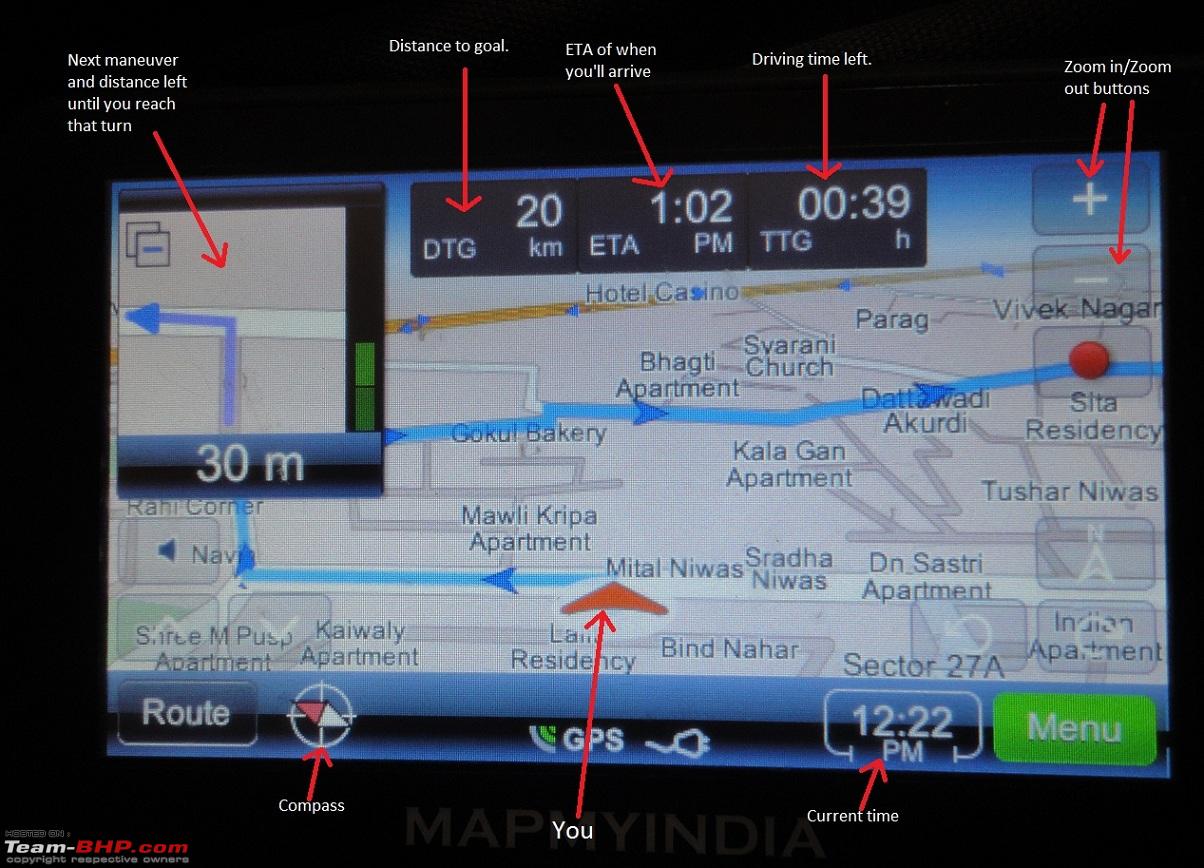 Zoomed out view of the route. Notice that the next maneuver box in the top left corner (red circled) can be minimized.  Maximum zoomed in view. I prefer keeping this view while driving. Notice the circled lock in the picture. You can lock the DTG, ETA etc data appearing on the strip in the red rectangle by tapping on the strip. In the unlocked view, this data will toggle after few seconds and the name of the road will start appearing there.  Maneuvers list. Useful for checking the maneuvers along the route the device has planned for you. If the name of the roads are known to the device, the maneuvers description will appear something like "Turn left on MG road".  Okay, now on to the review. I've given the device a rating on various parameters below, on a scale of 0 to 5; 0 being the worst and 5 being the best. Turn by turn navigation: 2.5/5 It has turn by turn navigation, audio as well as visual. On the top left corner, you see the next turn/maneuver you’ve to make and the distance left until you’re at that maneuver. The audio nav also periodically reminds you about along with the distance left, saying something like "In one-point-five kilometers, turn right". I’ve seen that sometimes the audio reminder does not fire and you may miss the turn. So you cannot depend on the audio nav and need to keep an eye on the screen for the next maneuver. The audio nav also gives wrong information at times, speaking left instead of right and vice versa. So need to double check with what’s on the screen. Highyway usage and accuracy: 2.5 Highway accuracy should’ve been much better given the roads hardy change. I’ve faced numerous accuracy problems on highways. Some are due to the bugs in the navigation software, while some are due to wrong map data. It has sometimes led me on a longer route, onto bad roads, led me into no entry zones and some risky situations. Highways I’ve travelled so far with this device: Pune to Hyderabad and back, Pune to Delhi and back, Pune to Jalna and back. Pune to Goa and back. Pune to Nagpur and back. Pune to Shirdi and back. City usage and accuracy: 3/5 My city usage has been very less, I never use it in Pune as I know my way around here. I’ve used it sparingly in the outskirts of Pune. Other than that, I’ve used it in Delhi, Hyderabad, Goa and Nagpur. Inside cities, it has performed very accurately in the sense that it never led me into one ways etc where I could get fined. I do not know if the path it led me through was the shortest or the best path in terms or roads. For city usage also, due to the bugs it has (details below), it may lead you through longer and very longer paths so again it has to be used with caution. Display Size: 3.5/5. Good enough for the price. Display brightness: 3.5/5. Good enough for the price. Battery life: 2/5. Battery life is lousy, lasts about 3 hrs on a full charge. The MMI dealer who sold me this said it’ll last an entire day on a full charge, but I didn’t expect it too so wasn’t too surprised with the real life battery performance. This is not an issue if your car has a 12V socket since a car charger is provided. The charger (both normal and car charger) go into the standard mini USB port on the device, so if the charger goes kaput you can buy another one from the market instead of buying from MMI and paying a premium. Sound clarity and loudness: 2/5. Bad for the price. Sound is very unclear and during initial days of use, it is hard to understand what the lady is saying. Volume is not loud enough, it has a single speaker which proves insufficient. With all the windows closed in a Polo, and cruising at about 80 kmph, I want the volume to be at least 1.5 times the max it currently provides. I’ve used similarly priced GPS units in US that have much better audio clarity and are quite loud enough. They also have a roller button on the side for volume so you can quickly adjust it. To adjust volume on this unit, you’ve to navigate through the settings menu etc etc, in short, cannot be done while driving. You get used to the clarity though, since there aren’t many keywords you have to identify. Satellite fix time: 3/5. Average, sometimes good. I didn’t find the car roof obstructing the time it takes to hunt enough satellites to calculate your position and route. Average time 30 secs to 1 minute. I’ve noticed that getting out of the car and clear skies don’t help much. I haven’t tried it under extremely cloudy skies. And if you’re under your concrete house roof, satellite fix doesn’t work. Touch sensitivity and accuracy: 2.5/5. Touch sensitivity and accuracy are average with your finger. Don’t expect an iphone like response, not even a micromax touchphone like response. With the stylus, the accuracy improves slightly but not by much. Windshield mount: 4/5. Very good. It’s that vaccum type rubber mount. In 9 months of sticking to the windshield, the mounting came off only once. I’ve driven on some very bad roads during this time. The mount is slightly big though, obstructing view slightly. Issues that I've faced so far: There are two types of problems I’ve seen happening with the device: bugs in the navigation software itself thereby resulting in faulty behavior, and wrong map data. It has led me into bad roads, longer routes and once into a risky situation with the army folks. When more than one of these problems/bugs occur at the same time/same maneuver, it gets worse. Software problem 1: Audio reminder for the next turn not firing. If it happens and you are not keeping an eye on the next maneuver shown on the display, you’ll miss the turn. It happens quite frequently on this device. On a 100KM drive on the highway, it may happen 3 to 4 times. I had previously used a GPS provided by Hertz in US, and in the 2000 miles of usage (70% highway), this kind of audio reminder not firing happened only once. Software problem 2: Okay, so you missed the turn. Now what does the device do? It sees the direction you’re travelling and recalculates the route. It might ask you to take the next turn coming up very soon, or may ask you to take a U turn. Problem is, when it does the recalculation, it should say that out loud, so that the driver is immediately reminded that he missed the turn and the route is being recalculated. This route recalculation audio warning is entirely missing feature on this device. The device I used in US used to audio remind me when it recalculated the route. This may not seem very important, but due to another problem I mention below, this missing feature becomes very costly. Software problem 3: Okay so you missed the turn, lets say a left turn, and it recalculated the route in the next 5 to 10 seconds. What should be the best route now? If another left turn is immediately coming up that can lead you to your destination, that new turn should be shown. The map data also stores possible U turns on divided highways (not sure about the accuracy of this U turn data though). So if the next left turn is very far ahead and will make your route longer, and if it is less costly to take a U turn, the device will pick that route. I've seen cases from both the scenarios happening. Problem is, this bugger doesn’t do this very accurately all the time. I missed a turn once, the highway was undivided two lane, and it did not ask me to take a U turn, but recalculated and kept showing a straight route. This straight route was around 80 to 100 kms longer. I don’t understand why this route got picked, maybe the device thought there was no place to take U turns for a long long way. Had the device announced that it was recalculating the route, and then had then shown me the new 100 km longer route, I would’ve sensed that something is wrong. I would’ve stopped, asked directions from people, perhaps taken a U turn and gone back to the turn I missed, reprogrammed the destination etc etc. But since there was no announcement of recalculation, I kept heading straight on the new route, and realized after about 35 km when I noticed that my DTG (distance to goal) has somehow increased. For those who do the Goa to Pune route, this happened after I exited the Goa-Mumbai highway and took a right turn towards Sawantwadi. Next I had to take a left after sometime for Sawantwadi, but I missed that left and kept heading straight. After realizing my mistake, I didn’t turn back but kept heading where the GPS was taking me, thinking there’s not much point left in going back. This new route started turning bad and then worse, and I came to a very steep hill which we had to climb and the road was so much broken that the tyres were slipping on the small broken stones on the road surface. Those 15 kms of crossing that hill took around 1.5 hrs and it was the worst road I’ve ever driven my car across. If you’ve seen the Manali to Rohtang road, this was similar, both in terms of climbing steepness and road surface. Wrong map data: This is less frequent but is present. I remember two huge instances of wrong map data. I was doing a Pune to Delhi trip. The route I planned (with help from teambhp, thank you guys, you rock!!) avoided the Ankleshwar – Bharuch narmada bridge on NH8, instead I went into Ankleshwar city, crossed over to Bharuch, and was heading back towards the highway. We have to take a right turn at a circle to go towards highway, but the device asked me to go straight, leading me to a factory gate. The factory guards didn’t allow us inside but showed us the correct way towards the highway. While returning back to Pune, the GPS was again leading me through the factory from the opposite side. Another similar incident which could’ve gone very ugly was when I was doing the Pune – Nagpur stretch. I was going via the Wardha route, Amravati route was all dug up. Around 60 kms before Wardha, there was an army base. For civilians, the route was to go around the army base, taking a left just before the gates of the army base. The GPS asked me to go though the base, we slowed down to walking speeds, and passed the gate reluctantly, and no one stopped us. Went around 100 meters inside, stopped, asked directions from an army man, turned back and reached the gate. The soldiers at the gate stopped us this time, and an officer level person arrived immediately on a bike. Then followed a 20 min confrontation of why we had not stopped at the gate and crossed. We kept apologizing very very politely to the officer, agreeing to our mistake, blaming the GPS, and what not. The soldiers kept insisting in front of the officer that they tried to stop us, waving hands but we did not respond. We knew it was not true, but kept quiet since the soldiers were in very angry mood and things could turn very ugly very fast with the slightest change in our tone. After a lot of grueling from the officer, some choicest of abuses from him in english, and lots of hindi abuses from the soldiers, we were allowed to go. I wanted to sue MMI after this incident, but I know nothing will come out of it. The least I can do is make others aware of my experiences with their products and accuracy of their maps. Tips and tricks on usage of this device:
Some other features:
Map updates: There are various plans available on the MMI website, I haven’t tried updating the maps yet. There is also a mention about premium content that can be bought for INR 2000. This will give you house number details for some cities. I’m not keen to update it, will probably think about it in a few years time. Last edited by nec2152 : 18th April 2012 at 16:30. |

|  (20)
Thanks (20)
Thanks
 |
| The following 20 BHPians Thank nec2152 for this useful post: | arnabchak, flyingkolors, GTO, im_srini, naut, niv26, PatienceWins, PGNarain, PM - B, rajeshchand, raj_5004, rider_no46, Sachin4920, sagarpadaki, SDP, Sutripta, swarnava.m, tasuray, Urban_Nomad, vinya_jag |
| |
|
19th April 2012, 09:35
| #2 |
| BHPian Join Date: Oct 2011 Location: Mumbai
Posts: 159
Thanked: 34 Times
| Re: Mapmyindia GPS navigator VX140S review Nice detailed review Nec2152. Really helpful for people(like me) who were/ are considering a GPS navigator. Do post some pics of the device in your Polo. |
|
| ()
Thanks
|
|
19th April 2012, 09:58
| #3 |
| BHPian Join Date: Jul 2006 Location: New Delhi
Posts: 317
Thanked: 6 Times
| Nice review! I have used the Sygic navigation software on my phone. It also uses maps from MMI. So far, in terms of map accuracy, it hasn't let me down. I wonder if its possible that there is some difference in the maps used by the two softwares. |
|
| ()
Thanks
|
|
19th April 2012, 11:11
| #4 |
| Distinguished - BHPian  | Re: Mapmyindia GPS navigator VX140S review @NEC2152, thanks for the review. The ETA & TTG are based on an average speed of 50kph, so this is not always applicable - esp if you are driving on highways. The unit is quite sensitive: 1. Once it locks, it will work even if you keep it flat down. 2. Last week I was on the highway, and had to follow the service road instead of the main highway. The difference between the path on highway & the path on service road was about 12 m. Yet, the position it showed was parallel & discrete from the highway (as seen on the map screen). I noticed that some district head quarters are not updated. Eg: Karwar. More updates later, but I have queries for other MMI / vx140s users: Have you been able to use the GPS logs, like with Google Earth ? (I was able to save the gps logs as .kml files, and then opened these in Google Earth, but it only showed the path I took. I could not find the spots I had marked, or the time related data for my logs/path) The Bad: Center pin of the mobile/car charger broke after just two uses. |
|
| (2)
Thanks
|
| The following 2 BHPians Thank condor for this useful post: | GTO, nec2152 |
|
19th April 2012, 18:51
| #5 | ||||||||
| BHPian Join Date: Nov 2006 Location: Bangalore
Posts: 522
Thanked: 1,720 Times
| Re: Mapmyindia GPS navigator VX140S review I have been using mapmyindia navigator (Road Pilot) since a couple of years now and I am mighty impressed by the device. It definitely gives much better directions than the person I ask for en route which is 90% of the time wrong. I have driven long distances solely relying on this device without having a clue of the place and it has helped. I love the feature of finding a location on the google maps, getting the coordinate, feeding it to the device and presto, here I am. Quote:
Quote:
Quote:
Quote:
Quote:
Quote:
Quote:
Quote:
Last edited by abhisheksircar : 19th April 2012 at 18:55. | ||||||||
|
| (1)
Thanks
|

| The following BHPian Thanks abhisheksircar for this useful post: | nec2152 |
|
20th April 2012, 09:15
| #6 | |||||||||||
| BHPian Join Date: Mar 2012 Location: Pune
Posts: 51
Thanked: 144 Times
| Re: Mapmyindia GPS navigator VX140S review Quote:
View from back seat: 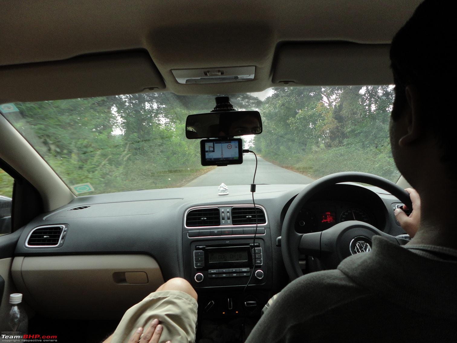 View from driver seat:  Comparing the size of the device with the 7 inch RVM. I have marked the rotation adjustments that are possible for pointing the device display in a particular direction. I keep it pointing towards my (driver's) face. 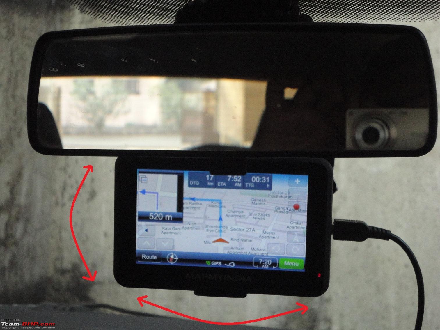 Quote:
Quote:
The device I used in US was quite bad in this regard. The turn might be 50 meters away but it would tell me to take the turn. Or the turn already passed and then the device tells me to turn. That was very annoying and in the initial 3-4 days, I used to mess up at around 50% of the turns. And the situation getting more confusing with more people in the car, everyone telling me what to do. More opinions, more confusion. I would then ask everyone to shut up and let me drive  Quote:
Quote:
 Quote:
On highways, both fastest and shortest are risky, it might chart out a crazy route for you. Heck, even optimal has put me into trouble at times. In this case, the tips I posted in post#1 will help. Quote:
It would be interesting to see how the HU's of cars like XUV behave that have built in navigation. My guess is that it should turn up the volume of music as well as navigation voice as the speed increases. Quote:
| |||||||||||
|
| (4)
Thanks
|
| The following 4 BHPians Thank nec2152 for this useful post: | arnabchak, AvinashV, GTO, naut |
|
20th April 2012, 10:26
| #7 |
| Senior - BHPian | Re: Mapmyindia GPS navigator VX140S review Excellent review, all the problems listed are spot on, I have been using this for last six months and not once did it mislead me into a incorrect or longer route. One of the other problems i have noticed is sometimes it takes forever to lock on to GPS satellite, and in that delayed connection time you re essentially lost and have to depend on asking folks. This happened to us while crossing HYD. Apart from this sometimes i felt the inside city routes were incorrect (i felt that way, have no way to validate). While on our return journey when crossing HYD it took is ~2-3 hrs to cross HYD itself in evening peak traffic. I am not really sure if the route it took us through was the most ideal. |
|
| (1)
Thanks
|
| The following BHPian Thanks mayankjha1806 for this useful post: | nec2152 |
|
20th April 2012, 13:00
| #8 | |
| BHPian Join Date: Oct 2011 Location: Pune
Posts: 240
Thanked: 78 Times
| Re: Mapmyindia GPS navigator VX140S review Quote:
What works best within the city here is setting it to the "fastest" setting - the optimal also takes you through narrow / old roads etc. The reason why you might have got stuck in the peak hour city traffic might be due to the challenge with the maps - the ORR which takes you around the city & helps you miss the traffic is for most parts not updated on the maps. Last edited by vkaul1 : 20th April 2012 at 13:01. | |
|
| (1)
Thanks
|
| The following BHPian Thanks vkaul1 for this useful post: | nec2152 |
|
20th April 2012, 14:28
| #9 |
| BHPian Join Date: Dec 2010 Location: Bangalore
Posts: 254
Thanked: 241 Times
| Re: Mapmyindia GPS navigator VX140S review Hey nec2152! Awesome review there!. Thanks for sharing. Aren't you using the latest MAPs from MMI, version 7 or something? I was contemplating buying one of MMI's devices myself for a 1200 Km roundtrip that I did last weekend but backed off due to lack of sufficient reviews and non-trivial initial investment. Things about MMI that are not to my liking are: 1. MMI doesn't promise/gaurantee that future verions of maps would be backward compatible with all their MMI devices (even for a price). At the very least they should publish till when (in terms of no of years) they plan to support a device (say "Road pilot will receive MAP updates for purhcase till 2015" etc). 2. All I want is no frills navigation. I would rather have a good HU for all my ICE. So I wanted to pick up the "Road Pilot" model which retails @ Rs.7990/-. However, reason 1 above is stopping me from doing the same. All the other models have multimedia support which I don't need anyway. 3. Map upgradation also sounds a little weired. All that SD card stuff!. If you loose the card, support is not smooth. Once I buy a license from MMI, I should be provided a mechanism to make a new copy of my legally purchased Maps into a new SD card and use the same with my MMI device. God knows what prevents them from allowing it!. (May be they are too afraid of people misusing this to get navigation & updated maps free!). 4. I read elsewhere also that the audio quality is not that good (as you've mentioned volume is not sufficient). This is a key aspect of any navigation software IMHO. Needs to be fixed. 5. The bugs shared by you definitely need fixing. Does MMI offer firmware upgrade for MMI devices at all? Or do you have to live with the bugs mentioned above forever? I wouldn't mind paying a little extra for firmware updates. 6. Lastly out of curiosity, can I have navigation & multimedia playback (say audio) on the MMI device simultaneously? In this case, does the device pause the music when directing me to take a turn? Otherwise, I can't see a use for the multimedia features on a navigation device. Keep us posted on your findings. Last edited by naut : 20th April 2012 at 14:29. Reason: Spelling mistake correction |
|
| ()
Thanks
|
|
20th April 2012, 14:37
| #10 |
| Senior - BHPian | Re: Mapmyindia GPS navigator VX140S review The other area i think MMI misses out of most of the bypass, i am not too sure if they were recently built (It did not seemed so). Either way while crossing a town via the Bypass the car arrow would show going nowhere and after a few kms would join back on the main highway. Most of the time passing through small towns this was ok, but when we had to pass a big town using bypass the MMI showed us going no-where for a very long time and after a while it gets confusing if we are really on the right track or need to take a different route. |
|
| ()
Thanks
|
|
20th April 2012, 16:53
| #11 |
| Newbie Join Date: Oct 2011 Location: Pune
Posts: 14
Thanked: 11 Times
| Re: Mapmyindia GPS navigator VX140S review I am using Garmin Nuvi, widescreen GPS device with MMI maps from 2010. Earlier i was using Satguide maps, but then later shifted to MMI. I have also tried using MMI from iPhone, BB, anaroid etc. as well. My conclussions from my experiences:
-Prawaal |
|
| (3)
Thanks
|
| The following 3 BHPians Thank Prawaal for this useful post: | Chewbacca, mayuresh_w, nec2152 |
| |
|
20th April 2012, 18:52
| #12 | |
| BHPian Join Date: Mar 2012 Location: Muz-Pune,
Posts: 80
Thanked: 20 Times
| Re: Mapmyindia GPS navigator VX140S review Quote:
I am able to take backup of my sd card and use either of the card in the slot to use the MMI. Even if you go on MMI website they mentioned like this: " MapmyIndia recommends to all its customers to back up the data on their SD card/device memory before starting an update. MapmyIndia will provide phone support and email support to facilitate the process at the customer's end, up to reasonable limits. MapmyIndia shall not be responsible, by any means whatsoever, for any damage/corruption of maps and software during the update process due to any factors beyond its control." So you have backward compatible in a sense you can delete the new version and use the old one or you can have both in two diff cards and use whichever card you want.  I am not using the device of MMI so no idea if device of MMI supports all this options or not but my Blaupunkt HU supports all this. I am not using the device of MMI so no idea if device of MMI supports all this options or not but my Blaupunkt HU supports all this.Except some route calculation issue i am pretty happy with this one. | |
|
| (1)
Thanks
|
| The following BHPian Thanks aditya@pune for this useful post: | nec2152 |
|
21st April 2012, 14:57
| #13 |
| BHPian | Re: Mapmyindia GPS navigator VX140S review I bought the VX 140 almost exactly a year ago. My charger centre pin has broken after 4 to 5 uses. Disappointing. Now I am unable to use the GPS till MMI get it fixed. I have also faced most of the issues mentioned below. Wrong directions. Wrong way to turn audio signals etc. etc. I have decided that one has to use a bit of common sense as well as the GPS. Also, I found it be not be very user friendly especially if one is in a hurry and trying to find a place. All in all, I would rate it as 2.5 / 5.0. I would not buy this make again. Regards, SS |
|
| (1)
Thanks
|
| The following BHPian Thanks suzuki san for this useful post: | nec2152 |
|
21st April 2012, 20:56
| #14 | |
| Senior - BHPian Join Date: Jul 2009 Location: Calcutta
Posts: 4,668
Thanked: 6,217 Times
| Re: Mapmyindia GPS navigator VX140S review Quote:
Convert the raw .bin files. Internal .kml files strip both time and altitude. Regards Sutripta | |
|
| (1)
Thanks
|
| The following BHPian Thanks Sutripta for this useful post: | condor |
|
22nd April 2012, 19:22
| #15 | ||
| Senior - BHPian Join Date: Mar 2007 Location: Bangalore
Posts: 8,069
Thanked: 2,919 Times
| Re: Mapmyindia GPS navigator VX140S review Quote:
) *and* the current speed, and not a constant 50kmph. Keeps reducing if you driving faster than the internally calculated average. Class of Road defines the line thickness and color that shows up on the map display. Used to be settable in MMI a long while back, not sure if those average speeds are user-configurable now.Quote:
The 'spots' that you had marked are stored in the PoI database when you save them, not in the tracks. Hence they don't show up in the kml file. | ||
|
| ()
Thanks
|
|