Team-BHP
(
https://www.team-bhp.com/forum/)
Quote:
Originally Posted by A350XWB
(Post 4487803)
Totally agreed. All I wanted to say is that it's not as simple as "a speedometer malfunction" when it comes to an aircraft.
Small correction, it was AF447 :)
Below is the flight profile from the accident day and the next day. The accident flight never achieved the planned altitude after ~5000ft and kept fluctuating after that, until it went into the final dive.
|
The scales of the graphs aren't the same. The ill fated flight lasted about 15 minutes, which corresponds to the first segment of the other flight. It does seem that there was an issue that prevented it from climbing further, but the attained altitude at seems to be failrly consistent with respect to time in both cases.
Quote:
Originally Posted by suresh_gs
(Post 4487806)
I can recall a similar accident pertaining to Air India 855 back in 1978. The cause for the accident was Spatial disorientation. The flight took a right turn upon take off and then became steady while the instrument stated that the plane was still banking to the right. To counter this, the pilot took a left turn hoping to steady the plane which resulted in the plane crashing into the Arabian sea.
Looks like the Lion Air crash is pretty similar to what I mentioned above.
|
I doubt it. Spatial disorientation is very rare for instrument rated pilots. It is very common for non instrument rated pilots who accidentally find themselves in poor visibility conditions. Obviously, these pilots were instrument rated.
Instrument flying means you base your actions on what the instruments are telling you, not what your body/mind is telling you.
Also, as far as we know the visibility at the time was good. They never climbed into the cloud base. It is very rare for any pilot, be it instrument rated or not, to suffer from spatial disorientation when you still see a horizon.
Jeroen
Quote:
Originally Posted by suresh_gs
(Post 4487806)
I can recall a similar accident pertaining to Air India 855 back in 1978. The cause for the accident was Spatial disorientation. The flight took a right turn upon take off and then became steady while the instrument stated that the plane was still banking to the right. To counter this, the pilot took a left turn hoping to steady the plane which resulted in the plane crashing into the Arabian sea.
|
In the case of Emperor Ashoka (AI855), it was more of bad CRM than spatial disorientation that doomed the flight. The captain's AI (Attitude Indicator) had a problem and showed a right bank, even after the plane had leveled out. Irony was that both the co-pilot's and the third set of backup instruments were showing correct bank angle. Nobody in the cockpit tried to check this instrument agreement, till around 5 seconds before the impact when the flight engineer finally seemed to have realized this. By this time, it was too late.
Quote:
Originally Posted by swissknife
(Post 4487817)
The scales of the graphs aren't the same. The ill fated flight lasted about 15 minutes, which corresponds to the first segment of the other flight. It does seem that there was an issue that prevented it from climbing further, but the attained altitude at seems to be failrly consistent with respect to time in both cases.
|
The scale is not the same. It is the UTC time which is shown on the time line. But, let's see this minute by minute. (You can see
flightradar24 for real values)
PK-LQP - The accident aircraft B737MAX-8
PK-LGS - B737-900 flown the next day
PK-LQP 23:21:30 210kt 925ft
PK-LGS 00:12:02 178kt 1075ft
PK-LQP 23:22:30 265kt 2050ft (Init+1m)
PK-LGS 00:13:02 260kt 2450ft (Init+1m)
PK-LQP 23:23:35 298kt 3200ft (Init+2m5s)
PK-LGS 00:14:09 279kt 6300ft (Init+2m7s)
PK-LQP 23:24:30 289kt 5075ft (Init+3m)
PK-LGS 00:15:18 294kt 10475ft (Init+3m16s)
PK-LQP 23:25:35 300kt 5035ft (Init+4m5s)
PK-LGS 00:16:07 340kt 12325ft (Init+4m5s)
PK-LQP 23:26:40 318kt 5050ft (Init+5m10s)
PK-LGS 00:17:18 363kt 15975ft (Init+5m16s)
The difference in climb rate is obvious. After 3 minutes into the flight, the ill fated aircraft (PK-LQP) never gained any altitude. In comparison, PK-LGS was @15,975ft by 5m and 16s. I'm also attaching the previous day's flight profile (Oct 28th, flown using PK-LPQ B737-800). Here also, at 5m and 7s, the flight was at 271kt & 13050ft. So, the climb rate of PK-LQP was nowhere near to the standard one on the route for the type.

Quote:
Originally Posted by Jeroen
(Post 4487838)
I doubt it. Spatial disorientation is very rare for instrument rated pilots. It is very common for non instrument rated pilots who accidentally find themselves in poor visibility conditions. Obviously, these pilots were instrument rated.
Instrument flying means you base your actions on what the instruments are telling you, not what your body/mind is telling you.
Also, as far as we know the visibility at the time was good. They never climbed into the cloud base. It is very rare for any pilot, be it instrument rated or not, to suffer from spatial disorientation when you still see a horizon.
|
clicked submit reply to soon. Just to add:
The problem with instrument rated pilots starts when their instruments give them incorrect information/readings. Without visual clues (i.e. horizon) pilots are trained to go by instruments alone. So first they need to be aware that there is a problem with one or more of the instruments, then they need to figure out the next course of action.
As both pilots have a full set of flight instruments in front of them, usually they will quickly note if one of them is showing different readings. During critical phases such as take off on most planes the pilot not flying will check indicated speed read outs of both displays for instance during the take off roll. They need to be similar.
Under certain conditions alarms are raised by defective instruments but not always. To date pitot tube are used to measure air speed. There have been crashes due to the fact the pitot tube cover wasnt removed before flight. Wasnt noted during walk around inspection.
Quite a few cases of insects nesting in pitot tubes etc. The pitot tube doesnt know this. If just provides a differential pressure measurement to the flight computers
Jeroen
Quote:
Originally Posted by Jeroen
(Post 4487922)
To date pitot tube are used to measure air speed. There have been crashes due to the fact the pitot tube cover wasn’t removed before flight. Wasn’t noted during walk around inspection.
Quite a few cases of insects nesting in pitot tubes etc. The pitot tube doesn’t know this. If just provides a differential pressure measurement to the flight computers
|
Would GPS be able to provide another alternate backup (assuming such a system isn't already in place)? Such that if the drift between GPS speed and pitot exceeds a threshold, a warning is raised?
With aircraft being away from ground clutter, they should be able to get a better GPS fix, than terrestrial receivers, and GPS works up to receiver speeds 1,000 knots (1,900 km/h; 1,200 mph) and a receiver altitude of up to 18,000 m (59,000 ft).
Quote:
Originally Posted by Jeroen
(Post 4487956)
GPS provides ground speed. GPS speed can vary wildly to true air speed.
|
Ah, as someone who only pilots wheeled vehicles, I clearly forgot about the influence of wind. :)
Quote:
Originally Posted by arunphilip
(Post 4487936)
Would GPS be able to provide another alternate backup (assuming such a system isn't already in place)? Such that if the drift between GPS speed and pitot exceeds a threshold, a warning is raised?
With aircraft being away from ground clutter, they should be able to get a better GPS fix, than terrestrial receivers, and GPS works up to receiver speeds 1,000 knots (1,900 km/h; 1,200 mph) and a receiver altitude of up to 18,000 m (59,000 ft).
|
GPS provides ground speed. And yes, as a rough back up in combination with other instruments they should be able to use this.
GPS speed can vary wildly to true air speed. Jet streams run at 100-150 knots easily. But even at these low altitudes (5000 feet) wind speeds could easily be 50 knots. So if you are close to stall speed that can make a huge difference whether the wind comes at you, or is behind you. In most glass cockpits the navigation display will show (GPS) ground speed and it will also calculate relative wind speeds.
As I mentioned earlier, if airspeed was unreliable (and everything else was working well) trained pilot should be able to control the aircraft just fine.
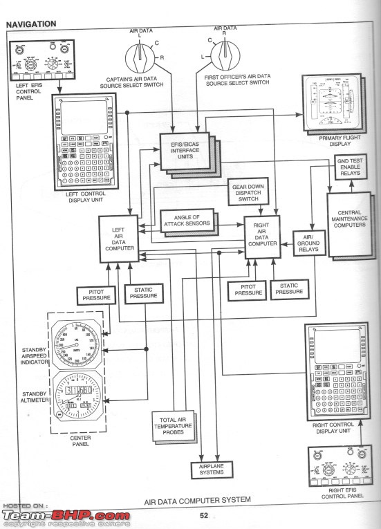
Just to illustrate some of the things mentioned in this thread. Below a simplified description of the so called Air Data Computer System on the 747-400 from one of my old manuals. The 737 MAX will have something similar, probably even more elaborate as it is very much state of the art.
When it comes to airspeed there are a few important component. the pitot pressure and the static pressure. They feed both the standby instruments as well as the air data computers. A lot of redundancy built in.
The air data computers has numerous other inputs, such as able of attack, air temperature and various other parameters. It calculates things like true airspeed, angle of attack, overspeed etc and displays it on the Primary Flight Display.
Also note the two source selection switches for both captain and first officer. This will enable them to switch to different sources.
I have been wondering why flight data and voice records are not transferred on a continuous basis over the internet (via satellites) considering flights offer inflight internet access. Yes, the last few moments could have situations where the internet access could be disconnected, but if it's not, it would provide quick and easy access to data. We may probably have more information on flight MH370 if this were the case.
Quote:
Originally Posted by swissknife
(Post 4488128)
I have been wondering why flight data and voice records are not transferred on a continuous basis over the internet (via satellites) considering flights offer inflight internet access. Yes, the last few moments could have situations where the internet access could be disconnected, but if it's not, it would provide quick and easy access to data. We may probably have more information on flight MH370 if this were the case.
|
Part of the problem and mystery of MH370 was that the satcom got switched off! :Frustrati
I do not have the ultimate answer, but here are some thoughts:
Through various systems all sort of operational data gets send across satellite links continuously. Obviously, all sort of flight details such as speed, heading, altitude, but also the performance of all sorts of systems. Maintenance department get lots of data gathered and send during flights.
However, flight data and voice recorders collect an awful data, continuously and in real time. You would need more than just a sat com link, you need a continuous telemetry type of link to accommodate the sheer volume of data as it also needs to be real time, all over the world. Which is going to be very expensive.
Until MH370 the flight data and voice recorder were considered a pretty robust system. In nearly all accidents they were found eventually and in perfect order. Only a few cases over decades of aviation where they were damaged beyond repair or never found. Those are the odd one out cases.
In the end it is a question of how much safety can cost. This is probably a case where the actual safety of aircraft would be less than marginally improved, whereas the cost would be very substantial.
Just my 2 cents
Jeroen
Quote:
Originally Posted by A350XWB
(Post 4487910)
PK-LQP - The accident aircraft B737MAX-8
PK-LGS - B737-900 flown the next day
PK-LQP 23:21:30 210kt 925ft
PK-LGS 00:12:02 178kt 1075ft
PK-LQP 23:22:30 265kt 2050ft (Init+1m)
PK-LGS 00:13:02 260kt 2450ft (Init+1m)
PK-LQP 23:23:35 298kt 3200ft (Init+2m5s)
PK-LGS 00:14:09 279kt 6300ft (Init+2m7s)
The difference in climb rate is obvious. After 3 minutes into the flight, the ill fated aircraft (PK-LQP) never gained any altitude. In comparison, PK-LGS was @15,975ft by 5m and 16s. I'm also attaching the previous day's flight profile (Oct 28th, flown using PK-LPQ B737-800). Here also, at 5m and 7s, the flight was at 271kt & 13050ft. So, the climb rate of PK-LQP was nowhere near to the standard one on the route for the type.
|
Had a question. The values reported by flight radar are from ADS-B messages right? These are self reported by the airplane's on board systems. So what is the source of the airspeed and altitude being reported out? Is it the air data computer or is it GPS? If its the former, then these values themselves are suspect right?
Quote:
Originally Posted by MinivanDriver
(Post 4488480)
Had a question. The values reported by flight radar are from ADS-B messages right? These are self reported by the airplane's on board systems. So what is the source of the airspeed and altitude being reported out? Is it the air data computer or is it GPS? If its the former, then these values themselves are suspect right?
|
I am not hundred percent sure. But I don't think it would be air speed. ADS-B is all about knowing where a plane is, heading, altitude and speed. So ground speed is the obvious one and that would be measured by GPS.
Jeroen
They have found one of the black boxes of the plane 400 meters north east of the last reported location. It will take 2-3 weeks to read the data and approx 3 months to analyze it. Long way to go before we get actual answers to what happened in those fateful 13 mins.
Link -
https://edition.cnn.com/2018/11/01/a...ntl/index.html
Boeing Co. is preparing to send a bulletin to operators of its new 737 Max models warning that erroneous readings from a flight-monitoring system can cause the planes to aggressively dive, said a person familiar with the matter.
https://www.businesstimes.com.sg/tra...ing-on-737-max
Quote:
Originally Posted by Foxbat
(Post 4491482)
Boeing Co. is preparing to send a bulletin to operators of its new 737 Max models warning that erroneous readings from a flight-monitoring system can cause the planes to aggressively dive, said a person familiar with the matter.
[[/]
|
Looks like Boeing issued something:
URL="https://www.businesstimes.com.sg/transport/boeing-close-to-issuing-safety-warning-on-737-max"]https://www.businesstimes.com.sg/transport/boeing-close-to-issuing-safety-warning-on-737-max
| All times are GMT +5.5. The time now is 21:42. | |


