Team-BHP > Commercial Vehicles
Register New Topics New Posts Top Thanked Team-BHP FAQ


Reply
  Search this Thread
12,540 views
Old 2nd October 2020, 01:23   #1
Senior - BHPian
 
avishar's Avatar
 
Join Date: Oct 2008
Location: kolkata/bangalore,india
Posts: 2,901
Thanked: 4,143 Times
Pics: Network Survey Vehicles used by the NHAI

This my Today-I-Learned (TIL)

So it seems that after a contractor has finished work on a national highway project, before the contractor can be given the completion certificate, the new section of road has to be surveyed once over by what is called a Network Survey Vehicle (NSV)

These NSVs are fitted with LIDAR systems, cameras, GPS tracking, 360 degree camera to measure the road width, depth of works, the roughness of the road. The cameras also make sure the things like lane markings, median width, width of drains and signages are according to specification. In short, these vehicles create a virtual 3D map of the newly constructed highway, which is then checked over remotely to make sure the construction has followed the specifications before giving it the thumbs-up.

It was this tweet which caught my eye.

Quote:
Mumbai goa highway
KCC buildcon section
Network survey vehicle.
The Survey Vehicle is used for automatic collection of road inventory and pavement condition related data.MORTH has made it compulsory since Nov'19for such survey before issuing completion certificate

Pics: Network Survey Vehicles used by the NHAI-ejralkyu4aeedax.jpg

Pics: Network Survey Vehicles used by the NHAI-ejralkxuwaai5bd.jpg

Pics: Network Survey Vehicles used by the NHAI-ejralkxu0aazjl9.jpg

Pics: Network Survey Vehicles used by the NHAI-ejralmbuyai9wzl.jpg


Some digging around for information:


Road survey with network survey vehicle made mandatory

Quote:
In a bid to develop quality road infrastructure and ensure longevity of road corridors, all projects involving development of two, four, six and eight lanes and strengthening will have to be surveyed with a Network Survey Vehicle (NSV).

The NSV, which uses the latest survey techniques such as laser, Global Positioning System and video image processing tools, will have to be deployed before start of the work and thereafter at regular intervals as provided in the contract for each lane of pavement. The move comes close on the roping in of an independent engineer for supervision.

The inventory data include measurement of the pavement surface roughness, road geometrics such as gradient, horizontal curvature and cross slope, rut depth using spread lasers, sensor measure texture depth, mean profile depth, and the GPS coordinates -- longitude, latitude and altitude.

The Union Ministry of Road Transport and Highways has asked the States and Union Territories to take necessary steps to deploy an NSV.


As per the policy guidelines, the minimum parameter which has to be recorded during survey with NSV in each lane are as following, but not limited to :

(i) Inventory of Road: GPS coordinates, Pavement Type, Pavement Width, Terrain, Land use, Shoulder type and width, Drain Type and Width, Median Type and Width, Wayside Amenities, Crash barrier, Signage’s etc. (Note- All inventory items shall be recorded both side of road and Geo-tagged with images / 360 degrees panoramic views).

(ii) Condition of Road: Roughness, Rutting, Distresses (Cracking, Potholes, Bleeding, Surface failure etc.); (Note- All inventory items shall be recorded for each lane and Geo-tagged).


There seems to be two types of these NSVs. Some are fitted with LIDAR systems and some use software which can create 3D mapping and do image recognition via normal cameras. There is another application where software based 3D mapping and LIDAR systems is used, which is the self-driving system. Tesla uses cameras, while some of its competitors use LIDARs.

NHAI seems to have put out competitive bidding for both types of systems.


Here are two contractors which offer these services to NHAI.

First one is the 3D Camera system

Pics: Network Survey Vehicles used by the NHAI-news3571.jpg

New Generation Network Survey Vehicles Commissioned in Bhopal, India


Quote:
L. N. Malviya Infra Projects Pvt Ltd are our latest customers in Bhopal, India. Our engineers are pleased to successfully help them equip the ROMDAS system on a brand new locally sourced Tata Winger vehicle to collect data in hot, dry and dusty conditions. DCL is proud to provide its first “new generation” network survey vehicle that complies with the latest NHAI specifications in India.

LNM now owns a sophisticated system configuration that includes 360° camera and mobile mapping software package, LCMS with Geometry and Roughness upgrades, GPS (sub-meter), HRDMI and a rack mounted computer system. This ROMDAS system was provided through our distributor partners in the country, Complete Instrumentation Solutions (CIS).

Our engineers installed the system and provided extensive training to the LNM team. LNM has previously used the much expensive LIDAR systems and are excited about the commissioning of their new NSV. They plan to use it for post-construction compliance testing on their many projects across India.
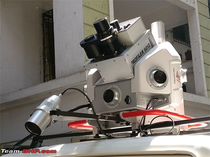
This is the LIDAR system


Pics: Network Survey Vehicles used by the NHAI-30d_pegasus_nsv.jpg

Network Survey Vehicle (NSV) Survey of 2/4/6/8 lane Highways


Quote:
We have all necessary resources and equipment in-house, like two numbers of “Leica Pegasus Two” NSV / Mobile LiDAR Instruments with pavement cameras, Leica GS14 DGPS RTK receivers, high capacity Work Stations, licensed software’s, skilled manpower, with sufficient experience, for Survey of Inventory of Road & Condition of Road as per MORTH policy requirements, with high quality and accuracy within optimum cost & given time frame.

The deliveries include the International Roughness Index (IRI), surface distress like potholes, cracks (crack index), rutting, bleeding shown in the vector form in *.dwg file by using the automatic ‘Road Assessment Tools’ of Leica Map Factory software.
  • NSV data of the pavement has to be collected for each lane with the speed of vehicle varying from 10 Km / hour up to 70 Km / hour. Ideal vehicle speed maintained by us is usually 40 to 50 Km / hour on Highways during each lane of NSV data capture.
  • Each run of NSV with pavement camera can capture about 3.5 m width of the highway lane with dense 3D point cloud data, 360 degrees panoramic view camera data with high density pavement camera and GNSS / IMU data.
  • Multiple runs are usually required for capturing more than one lanes on Highways and Expressways as per the project requirements.
  • In one day, about 100 lane Km length of NSV data can be easily collected by 'Leica Pegasus Two' NSV with pavement camera in a single run.
  • The raw NSV data collected on site is so dense (about 100 GB data collected for 100 lane Km length of highway) that it has to be downloaded into external hard disk and transported to the head office for further data processing and pavement analysis.


Pretty neat right?

They should use it for city roads too. If they do so, these systems will go haywire.

Last edited by avishar : 2nd October 2020 at 01:29.
avishar is offline   (90) Thanks
Old 4th October 2020, 13:18   #2
BHPian
 
SS80's Avatar
 
Join Date: Apr 2019
Location: Bangalore
Posts: 246
Thanked: 928 Times
Re: Pics: Network Survey Vehicles used by the NHAI

Quote:
Originally Posted by avishar View Post
This my Today-I-Learned (TIL)

So it seems that after a contracto roads too. If they do so, these systems will go haywire.
Never knew about this till date. Good share. If they have to build some similar machine for Bangalore roads, it needs the same spares used in making Chandrayan, as the craters might mimic the moon's surface.
SS80 is online now   (7) Thanks
Old 4th October 2020, 13:27   #3
Newbie
 
Aksfdb's Avatar
 
Join Date: May 2020
Location: Faridabad
Posts: 7
Thanked: 64 Times
Re: Pics: Network Survey Vehicles used by the NHAI

A great post and very informative as well. I never knew that such specialized systems exist with NHAI and they are used for inspections.
Thank you Avishar for a bringing out such information for ignorant souls like me.
Another reason why I feel proud to be associated with TBHP community.
Aksfdb is offline  
Old 4th October 2020, 21:16   #4
BHPian
 
Laxman9192's Avatar
 
Join Date: Aug 2019
Location: Porvorim
Posts: 36
Thanked: 42 Times
Re: Pics: Network Survey Vehicles used by the NHAI

Great post avishar. Working in the Real Estate sector I was aware of the concept of verification of works before awarding a completion certificate but could never have imagined such contemporary technologies being employed by the government. As a future daily user of this highway I am relieved.
Laxman9192 is offline  
Old 5th October 2020, 17:02   #5
AZT
BHPian
 
Join Date: Nov 2019
Location: Toronto
Posts: 680
Thanked: 2,577 Times
Re: Pics: Network Survey Vehicles used by the NHAI

Quote:
Originally Posted by avishar View Post

Pretty neat right?
Definitely. This actually reminds of the Google Maps vehicles in the US driving around with multiple cameras etc on top.
AZT is offline  
Old 5th October 2020, 19:58   #6
BHPian
 
turbospooler's Avatar
 
Join Date: Mar 2013
Location: Pune
Posts: 387
Thanked: 1,002 Times
Re: Pics: Network Survey Vehicles used by the NHAI

Wow. Added this to my TIL (Today I learnt) list as well!
I love these type of positive governance stories where we leverage technology to decide right and wrong and eliminate the table for under the table dealings.
Hope they upload the road data to an open forum so that further transparency will keep the contractors on their toes.
turbospooler is offline  
Old 6th October 2020, 14:07   #7
Senior - BHPian
 
Join Date: Apr 2010
Location: EU - Nordic
Posts: 2,052
Thanked: 3,043 Times
Re: Pics: Network Survey Vehicles used by the NHAI

A few weeks back, I saw it mentioned in an F1-related documentary that teams use LIDAR systems to scan and map out new circuits, to use the data in their driving simulators. It is cool to see the same (or similar) technology put to use to detect the quality of road works.
StarrySky is offline  
Old 7th December 2020, 20:37   #8
BHPian
 
Join Date: May 2016
Location: Bangalore
Posts: 71
Thanked: 127 Times
Re: Pics: Network Survey Vehicles used by the NHAI

Looks promising. I do hope NHAI strictly uses these vehicles' report to issue completion certificates to the road builders. Earlier, road contractors were bribing their way out of the projects.

For example, in Tamil Nadu, two to three years back, six lane road between Chengapalli and Coimbatore was completed after years of delay. The length of this stretch is about 45 kMs. We are still wondering how NHAI given completion certificate for this project. Even village roads are much better. Entire stretch is very bumpy. We often see vehicles jumping the median and ends up in the other side causing accidents. Moreover, all fly over expansion joints are mini speed breakers.

Hopefully, with these advanced quality control vehicles, road contractors do not get away with poor quality roads hear after.
samy1117 is offline  
Reply

Most Viewed


Copyright ©2000 - 2024, Team-BHP.com
Proudly powered by E2E Networks