Team-BHP > Shifting gears > Gadgets, Computers & Software


Reply
  Search this Thread
859,181 views
Old 6th September 2009, 21:16   #196
Senior - BHPian
 
Fountainheader's Avatar
 
Join Date: Feb 2008
Location: Silicon Valley
Posts: 1,501
Thanked: 13 Times

Thanks Sportsmind.

Guess I'll get the Garmin Nuvi from the US and load the Satguide 2183 maps. I find it really painful to check maps using my N82.
Fountainheader is offline  
Old 6th September 2009, 21:38   #197
Newbie
 
Join Date: Feb 2009
Location: pune
Posts: 0
Thanked: 0 Times

Quote:
Originally Posted by Fountainheader View Post
Thanks Sportsmind.

Guess I'll get the Garmin Nuvi from the US and load the Satguide 2183 maps. I find it really painful to check maps using my N82.
do have a look on Blaupunkt though... they come with navngo..
that's thw world best navigation software and maps r form mapmyindia.

Blaupunkt India - The advantage in your car.
indie is offline  
Old 6th September 2009, 22:51   #198
Senior - BHPian
 
Join Date: Oct 2005
Location: NA
Posts: 1,224
Thanked: 93 Times

Quote:
Originally Posted by indie View Post

Blaupunkt India - The advantage in your car.

they come pre loaded with navngo igo8 software.. which is the best navigation software in the world.
Its not exactly the best satnav software in the world. I have it on my SP and instead prefer TomTom. Yes iGo can show buildings in 3D etc but its hardly something you need if you just want good directions to get from A to B.
bigman is offline  
Old 6th September 2009, 23:51   #199
Newbie
 
Join Date: Feb 2009
Location: pune
Posts: 0
Thanked: 0 Times

Note from the Team-BHP Support : SMS / Slang is STRICTLY prohibited on this community. We would much appreciate your using full & proper english in posts, for the benefit of other forum users.

Please view our board rules carefully before proceeding any further.


Quote:
Originally Posted by bigman View Post
Its not exactly the best satnav software in the world. I have it on my SP and instead prefer TomTom. Yes iGo can show buildings in 3D etc but its hardly something you need if you just want good directions to get from A to B.
its your perception , igo8 is not the best .. the way u take it is not taken by others.. there are many software's in market..

so depends wat u like not wat others..

i was just talkin bt the availility of pnd's in india..

so it will be nice of you to talk in context rather than going off track.

in india map data is provided by mapmyindia & satguide only... like in other parts of world navteq & tele atlas has no say..

read about government policies regarding gis in india.

and for your kind information... igo8 maps in india are provided by mapmyindia.

MAPMYINDIA MAPS are only there on mireo, igo8 & garmin.

Last edited by GTO : 8th September 2009 at 13:06.
indie is offline   Received Infraction
Old 7th September 2009, 03:54   #200
Senior - BHPian
 
Join Date: Oct 2005
Location: NA
Posts: 1,224
Thanked: 93 Times

Quote:
Originally Posted by indie View Post
its your perception , igo8 is not the best .. the way u take it is not taken by others.. there are many software's in market..

so depends wat u like not wat others..

i was just talkin bt the availility of pnd's in india..

so it will be nice of you to talk in context rather than going off track.

in india map data is provided by mapmyindia & satguide only... like in other parts of world navteq & tele atlas has no say..

read about government policies regarding gis in india.

and for your kind information... igo8 maps in india are provided by mapmyindia.

MAPMYINDIA MAPS are only there on mireo, igo8 & garmin.
It would be nice of you to understand what you write before you accuse others of going offtrack. On the one point you state :

Quote:
they come pre loaded with navngo igo8 software.. which is the best navigation software in the world.
so was that your opinion? or was it an evidence based statement?

You appear to be telling everyone that iGo SOFTWARE is the best satnav s/w in the world. Come on please enlighten me and tell me what makes it better than the other offerings out there? Have you used it? What other satnav software have you used to come conclude iGo8 is the best?

MMI provide the mapping so please tell me how is iGo with MMI sourced maps better than Miomap/Mireo running similar maps from MMI?

Having used Garmin XT, Route 66, TomTom, Sygic McGuider, Destinator, iGo, Miomap, Polstar, Papago and Mapking I think I can come to my own conclusion that iGo is not the best out there. I find the GUI in TomTom7 easier to use, I find it easier to d/l and install speedcam POI files in TomTom. I even prefer the Mireo s/w to iGo. Papago and Mapking are towards the backend of my list, the last versions I used had poor GUI which could easily be improved to make them easier to use.

Destinator is a failure in Europe and has lost out to the offerings from TomTom and Garmin. TomTom have pulled the plug on its s/w for WM and Sygic have taken up the mantle. McGuider from Sygic has a nice GUI and is number 2 on my list, then it is the likes of Gamrin XT, iGo, Miomap etc.

Last edited by bigman : 7th September 2009 at 04:06.
bigman is offline  
Old 7th September 2009, 10:05   #201
Senior - BHPian
 
NetfreakBombay's Avatar
 
Join Date: Jan 2008
Location: Bombay
Posts: 1,466
Thanked: 1,021 Times

Quote:
Originally Posted by indie View Post
in india map data is provided by mapmyindia & satguide only... like in other parts of world navteq & tele atlas has no say..

This is wrong. I know for the fact that maps are available from :

1. Navteq (Used in Nokia maps, Garmin,Microsoft Live)
2. AND (Donated seed data for OpenStreetMap)
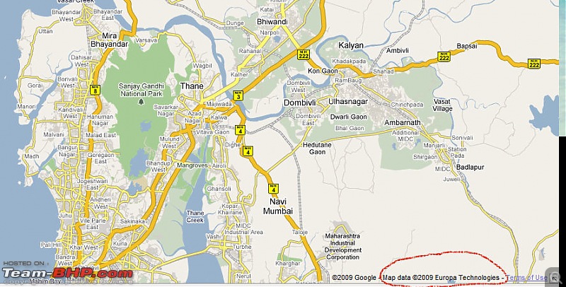
3. Europa (Used by Google Maps)

See at the bottom right part of most maps. It would have name of provider as copyright holder.

For example:

Europa maps in Google mpas:

The GPS/Maps Discussion Thread (Dedicated Satnav, Smartphones, Tablets, etc)-google_maps_europa.jpg


Navteq maps in MS Live maps:

The GPS/Maps Discussion Thread (Dedicated Satnav, Smartphones, Tablets, etc)-navteq_maps_live.jpg
NetfreakBombay is offline  
Old 7th September 2009, 19:04   #202
Senior - BHPian
 
jaysmokesleaves's Avatar
 
Join Date: Dec 2007
Location: Mostly Mumbai
Posts: 1,702
Thanked: 1,452 Times

Without wanting to intervene in the ongoing discussion, I wish to post a query:

I wish to purchase a gps navigation system for use in my car and portable to use while trekking. I require reliable maps and route guidance for travel across the country. I currently use a prehistoric map book

Following criteria are important: Economical, user friendly, reliable & portable. I intend to keep this device for a long time, so I do not mind investing in a good quality device. However, I do not want to be ripped off paying for maps every now n then.

Please advise.
jaysmokesleaves is offline  
Old 7th September 2009, 21:52   #203
Senior - BHPian
 
Join Date: Jun 2006
Location: bangalore
Posts: 1,266
Thanked: 309 Times

Quote:
Originally Posted by NetfreakBombay View Post
This is wrong. I know for the fact that maps are available from :

1. Navteq (Used in Nokia maps, Garmin,Microsoft Live)
2. AND (Donated seed data for OpenStreetMap)
3. Europa (Used by Google Maps)

See at the bottom right part of most maps. It would have name of provider as copyright holder.

For example:

Europa maps in Google mpas:


Navteq maps in MS Live maps:
Interesting topic. That's largely true. MS Live seems to be using Navteq and AND in different places (for eg. AND in BLR, Navteq in Delhi).

Yahoo uses CE Infosystems /mapmyindia maps. It is true that the coverage pan India for mapmyindia is much better than Navteq and Europa etc, though the gap is closing ...
lancer_rit is offline  
Old 7th September 2009, 22:53   #204
Senior - BHPian
 
NetfreakBombay's Avatar
 
Join Date: Jan 2008
Location: Bombay
Posts: 1,466
Thanked: 1,021 Times

Quote:
Originally Posted by jaysmokesleaves View Post
I wish to purchase a gps navigation system for use in my car and portable to use while trekking.
Tough thing.

In car, you need big screen, touch screen, high brightness. All things mean low battery backup.

For trekking, you need a rugged device with hours of battery backup.

I would suggest you pick up a Garmin handheld for trekking. Nothing even comes close.

For car, pick up any cheap Chinese device.

Quote:
Originally Posted by jaysmokesleaves View Post
I require reliable maps and route guidance for travel across the country. I currently use a prehistoric map book
Currently Map data is not good for highway coverage. Both major providers have several state highways missing.

Quote:
Originally Posted by jaysmokesleaves View Post
Following criteria are important: Economical, user friendly, reliable & portable. I intend to keep this device for a long time, so I do not mind investing in a good quality device. However, I do not want to be ripped off paying for maps every now n then.
You either can by a Cell phone that would be portable as well as reliable. But do carry 12 AA cells (2700 MAH or better) since cell would get discharged every 2 hours. With 12 cells + cell charges that charges off cells would keep it going for 2 days at a stretch.

Cell would serve the purpose of car navigation as well.

Or buy a Garmin unit that is made for outdoor use, is capable of handling dust/moisture/shocks. And buy a chinese unit for car.

In any case:

Cost of software would be $70 - $100.
Cost of maps would be 2k (sold by satguide)

Cell would do both jobs (trekking/car) though not perfectly.
Saperate devices (Garmin eTrek + Chinese car navigation unit) would cost around 15k.

Software + Maps are licensed on SD card so the same license would work on both.
NetfreakBombay is offline  
Old 8th September 2009, 18:33   #205
Senior - BHPian
 
jaysmokesleaves's Avatar
 
Join Date: Dec 2007
Location: Mostly Mumbai
Posts: 1,702
Thanked: 1,452 Times

Thanks NFB > last question: are the chinese makes reliable..?
jaysmokesleaves is offline  
Old 8th September 2009, 20:54   #206
Senior - BHPian
 
gd1418's Avatar
 
Join Date: May 2006
Location: Gurgaon
Posts: 3,578
Thanked: 728 Times

As reliable as the Chinese themselves...

Quote:
Originally Posted by jaysmokesleaves View Post
Thanks NFB > last question: are the chinese makes reliable..?
gd1418 is offline  
Old 9th September 2009, 00:40   #207
Senior - BHPian
 
NetfreakBombay's Avatar
 
Join Date: Jan 2008
Location: Bombay
Posts: 1,466
Thanked: 1,021 Times

Quote:
Originally Posted by jaysmokesleaves View Post
Thanks NFB > last question: are the chinese makes reliable..?
As compared to Garmin/Tomtom, not really.

Only advantage is, cost. You get Chinese device for 5 - 6k. Others cost 14k+.

However, if someone is visiting US, good devices cost $140 - $250. So you can look at that option.
NetfreakBombay is offline  
Old 9th September 2009, 01:14   #208
Team-BHP Support
 
Zappo's Avatar
 
Join Date: Oct 2005
Location: Hyderabad
Posts: 5,918
Thanked: 2,652 Times

At the cost of being repetitive (NFB and some others have heard it from me on another thread), a fundu Garmin Nuvi widescreen (205w) can be had for just about INR 7k equivalent in US. I got one recently through this route.

@NFB, it is probably not true about some of the highway coverages being not there in the India GPS maps. Recently I drove all the way from down south to the hills in the North Bengal, close to the borders. I went to places like Mirik where the road is a hill road from Bagdogra onwards and is a SH. It's a typical hill road and Mirik is like a blip on the world map. I never expected that my GPS loaded with Satguide map will be able to take me there (through all the night adventures that I unintentionally landed up with). But surprise! It did mann. Too good I must say. Of course the long journey always had the GPS on and I never missed a turn on any major highway that I crossed. Yeah, in small cities like cuttack and all the maps may not exactly be 100% but they are fairly accurate even there.

Finally, Satguide has released its latest maps which I guess is the 404 cities map they told us about when we went to their office last month.
Zappo is offline  
Old 9th September 2009, 01:36   #209
BHPian
 
Join Date: Jul 2004
Location: Utopia!
Posts: 595
Thanked: 105 Times

Are there any Windows (XP/Win7) based navigation software other than Mireo ViaGPS that can run maps from Map My India (MMI)?

I'm so sick of the Mireo ViaGPS Black Edition which crashes the moment I start driving.
Digital Vampire is offline  
Old 9th September 2009, 16:30   #210
BHPian
 
Join Date: Aug 2007
Location: Bangalore
Posts: 341
Thanked: 10 Times

Quote:
Originally Posted by Zappo View Post
@NFB, it is probably not true about some of the highway coverages being not there in the India GPS maps.
Finally, Satguide has released its latest maps which I guess is the 404 cities map they told us about when we went to their office last month.
I second that. I recently bought Satguide GPS system and was driving in this route Bangalore - Hyderabad - Sholapur - Pune - Bangalore. I am totally new to Hyderabad and the device did an excellent job of taking me through those congested areas of Koti/ABIDS etc. In Pune it guided me precisely from NH9 entry to NH4 without missing even a single turn.

Yes, there are glitches like some POIs missing, but that is evolving.

BTW, their new maps are released already and am using the new ones. Funnily the POI file size has decreased from 63MB to 45 MB and I was curious to know if they have added more POIs how did the size come down. For which the support guy promptly called on my mobile and explained that they used some compression technique to reduce the file size.

Nainar
anainar is offline  
Reply

Most Viewed
Thread Tools Search this Thread
Search this Thread:

Advanced Search

Copyright ©2000 - 2024, Team-BHP.com
Proudly powered by E2E Networks