Team-BHP > Travelogues > Route / Travel Queries
Register New Topics New Posts Top Thanked Team-BHP FAQ


Reply
  Search this Thread
875,442 views
Old 9th April 2009, 21:24   #166
BHPian
 
Join Date: Dec 2007
Location: Bangalore
Posts: 696
Thanked: 260 Times

Quote:
Originally Posted by GSMINC View Post
Last year I took 4 hours to cover the 16.5km stretch in my Santro.
I may be better, covered this down hill stretch in 3hrs at midnight in 2008 Feb. My father was actually walking in front of the santro to take out big stones..!!!

Nitin, please update once u r back. Looks buses are still not started plying through this route. Today's Deepika reported some irregularities in the road construction, looks it may get delayed again

Thanks
Rajesh
RajeshK is offline  
Old 9th April 2009, 21:36   #167
Team-BHP Support
 
Jaggu's Avatar
 
Join Date: May 2004
Location: Bangalore
Posts: 20,215
Thanked: 15,903 Times

Quote:
Originally Posted by nithinnarayanan View Post
Will be going to Kannur next week.
Will take this route and give an update.
Looking forward to this, i have 2+2 trips (next and week afterwards) and would really be useful.
Jaggu is online now  
Old 17th April 2009, 01:05   #168
BHPian
 
nithinnarayanan's Avatar
 
Join Date: Oct 2007
Location: Bangalore Kannur Manipal
Posts: 237
Thanked: 10 Times
Bangalore ~ Kannur Road condition update.

I am writing a full report, as requested by some fellow members and for people who have not taken this route.

Route : Bangalore ~ Srirangapatna ~ Hunsur ~ Tithimathi ~ Gonikoppal ~ Perumpady ~ Makuta ~ Kootupozha ~ Iritty ~ Mattanur ~ Kannur.
Distance : 315 Kms (Bangalore GPO to Kannur GPO)
Ride : Tata Indica DLX TC
Date Of Journey : 16th April 2009
Time Taken : 6.5 Hrs (including 45 min of break)

As every one knows about the road condition of the Bangalore Mysore highway, I am not including this stretch in the report.

The road from the Srirangapatna to Yelvala (mysore bypass to go towards madikeri) is Ok as it is recently patched.
From Yelvala to Hunsur the road is super and scenic and done-up recently.
Bangalore - Kannur : Route Queries-cimg0001.jpg

One can reach Hunsur from Bangalore in 3 hrs while maintaining an average speed of 90 ~ 110.
Once you cross Hunsur there is a Y junction after 5 Kms. You have to take the left lead which leads you to gonikoppal (the right road will lead you to Kushalnagar) This is a single road but good stretch, One had to be careful of the oncoming vehicles as you may have to take your vehicle off the road to give way.

After 7 Kms from the Y junction the Jungle starts. Though the road is good, one should be careful as the road is single and there are some sharp turns. 4Kms into the jungle leads you to the Forest Check post.
Bangalore - Kannur : Route Queries-cimg0006.jpg

After 6 Kms from the Forest Check post you will reach an arch bearing the name Rajiv Gandhi National Park, This is the entrance of Tithimathi, its a small town where you can find some tea-stalls in case you are travelling in the night.
Bangalore - Kannur : Route Queries-cimg0020.jpg

After 10 Kms from Tithimathi, you will reach Gonikoppal. Here you can stop for food at the Kamath Hotel (opposite Bus stand). This hotel is open from 6 Am to 10 Pm ans is famous for good food. This town also has a Tata Dealership cum service centre.
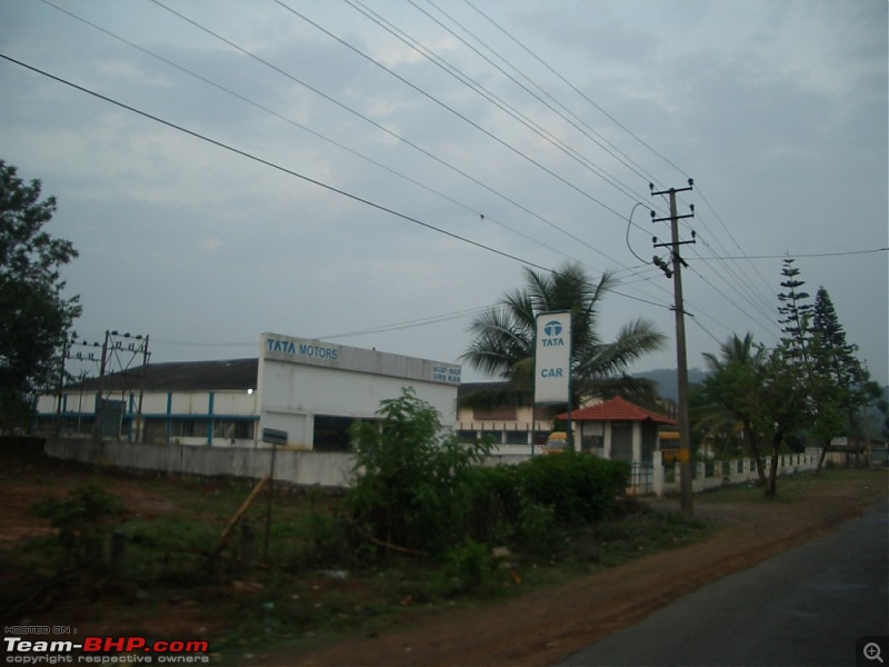
Bangalore - Kannur : Route Queries-cimg0033.jpg

After 12 Kms from Gonikoppal you will reach a stretch where you will find paddy fields on both sides of the road.
Bangalore - Kannur : Route Queries-cimg0034.jpg

Exactly 5 kms before Virajpet town there is a Y junction. You have to take the left lead which leads you to Maakuta (the right road will lead you to Virajpet). After this Y junction you will find two more Y junctions, which might confuse you. Keep taking the left side on both of these. You will get a 2 Km of bad road before you reach Perumpady Checkpost. But the taring of the same is going on and may be completed in 2 weeks.
Bangalore - Kannur : Route Queries-cimg0040.jpg

After you cross Perumpady Checkpost, the road is good for next 4 Kms.
Bangalore - Kannur : Route Queries-cimg0047.jpg
Bangalore - Kannur : Route Queries-cimg0050.jpg

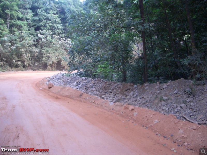
Here is where the work for the road is going on for the next 12 Kms.
Bangalore - Kannur : Route Queries-cimg0055.jpg
Bangalore - Kannur : Route Queries-cimg0059.jpg

The debris of the old road piled on both sides.
Bangalore - Kannur : Route Queries-cimg0061.jpg
Bangalore - Kannur : Route Queries-cimg0063.jpg

On the Dirt Track
Bangalore - Kannur : Route Queries-cimg0068.jpg

For the next 3 Kms you can cruise at 30~40 KMPH, after which next 3 Kms (near the hanuman temple) they are just putting the mud.
Bangalore - Kannur : Route Queries-cimg0069.jpg
Bangalore - Kannur : Route Queries-cimg0070.jpg
Bangalore - Kannur : Route Queries-cimg0072.jpg

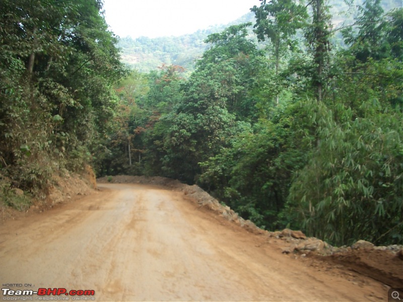
Again after the 3 Kms the road is laid by mud till maakuta.
Bangalore - Kannur : Route Queries-cimg0084.jpg

You will find culverts been constructed after passing the temple.
Bangalore - Kannur : Route Queries-cimg0089.jpg
Bangalore - Kannur : Route Queries-cimg0097.jpg

Finally you reach Maakuta
Bangalore - Kannur : Route Queries-cimg0098.jpg

After which the road is good till the Police check-post
Bangalore - Kannur : Route Queries-cimg0099.jpg

After crossing the Check-post you reach Kootupozha Bridge
Bangalore - Kannur : Route Queries-cimg0102.jpg
Bangalore - Kannur : Route Queries-cimg0103.jpg

Thereafter the road is good for the rest of the journey(40 Kms) till Kannur.

Last edited by nithinnarayanan : 17th April 2009 at 01:11.
nithinnarayanan is offline  
Old 17th April 2009, 10:01   #169
Team-BHP Support
 
Jaggu's Avatar
 
Join Date: May 2004
Location: Bangalore
Posts: 20,215
Thanked: 15,903 Times

Thanks so much Nithin, this is a big help. Am putting on the mud tires and trying this route tomorrow.

If the experience is ok (which looks like the case from your pics) then i think i can stick to this route for the remaining 3 drives also.
Jaggu is online now  
Old 17th April 2009, 18:31   #170
Senior - BHPian
 
kannan666's Avatar
 
Join Date: Aug 2007
Location: KA-02
Posts: 1,002
Thanked: 128 Times

@ nithinnarayanan

Thanks for such an excellent update !
kannan666 is offline  
Old 17th April 2009, 18:40   #171
007
BHPian
 
007's Avatar
 
Join Date: Apr 2009
Location: Nasik
Posts: 98
Thanked: 37 Times
You can use internet for route guidance.

Dear ,

You can use internet for route guidance.
It gives you route , distance as well as approximate time also.
Below are very useful links.

Yahoo! India Maps

Google Maps

Just make sure to use get direction link under it.

Wish you happy journey.
007 is offline  
Old 17th April 2009, 23:49   #172
BHPian
 
nithinnarayanan's Avatar
 
Join Date: Oct 2007
Location: Bangalore Kannur Manipal
Posts: 237
Thanked: 10 Times

Dear Mr Bond,

Welcome to the forum, as I see this is your first post.

As you can see the title of my report, this was not for route guidance but only a road condition update on the entire route which was abandoned by most of the people because of the lack of maintenance work on this road for the last 10 years.

And the route given by the below links you gave, does not have some of the stretches described in the report. Plus they have some unnecessary deviations from the route discussed in the report.

The approx time given by the links is not relevant as it does not give the road conditions.

Please go through the whole thread for better understanding of the reason for a detailed report on the route.


Cheers
Nithin

Quote:
Originally Posted by 007 View Post
Dear ,

You can use internet for route guidance.
It gives you route , distance as well as approximate time also.
Below are very useful links.

Yahoo! India Maps

Google Maps

Just make sure to use get direction link under it.

Wish you happy journey.
nithinnarayanan is offline  
Old 18th April 2009, 08:09   #173
BHPian
 
sarinkumar's Avatar
 
Join Date: Feb 2009
Location: Pune
Posts: 165
Thanked: 6 Times
Super report

Quote:
Originally Posted by nithinnarayanan View Post
I am writing a full report, as requested by some fellow members and for people who have not taken this route.

Route : Bangalore ~ Srirangapatna ~ Hunsur ~ Tithimathi ~ Gonikoppal ~ Perumpady ~ Makuta ~ Kootupozha ~ Iritty ~ Mattanur ~ Kannur.
Distance : 315 Kms (Bangalore GPO to Kannur GPO)
Ride : Tata Indica DLX TC
Date Of Journey : 16th April 2009
Time Taken : 6.5 Hrs (including 45 min of break)

As every one knows about the road condition of the Bangalore Mysore highway, I am not including this stretch in the report.

The road from the Srirangapatna to Yelvala (mysore bypass to go towards madikeri) is Ok as it is recently patched.
From Yelvala to Hunsur the road is super and scenic and done-up recently.
Attachment 126253

One can reach Hunsur from Bangalore in 3 hrs while maintaining an average speed of 90 ~ 110.
Once you cross Hunsur there is a Y junction after 5 Kms. You have to take the left lead which leads you to gonikoppal (the right road will lead you to Kushalnagar) This is a single road but good stretch, One had to be careful of the oncoming vehicles as you may have to take your vehicle off the road to give way.

After 7 Kms from the Y junction the Jungle starts. Though the road is good, one should be careful as the road is single and there are some sharp turns. 4Kms into the jungle leads you to the Forest Check post.
Attachment 126254

After 6 Kms from the Forest Check post you will reach an arch bearing the name Rajiv Gandhi National Park, This is the entrance of Tithimathi, its a small town where you can find some tea-stalls in case you are travelling in the night.
Attachment 126255

After 10 Kms from Tithimathi, you will reach Gonikoppal. Here you can stop for food at the Kamath Hotel (opposite Bus stand). This hotel is open from 6 Am to 10 Pm ans is famous for good food. This town also has a Tata Dealership cum service centre.
Attachment 126256

After 12 Kms from Gonikoppal you will reach a stretch where you will find paddy fields on both sides of the road.
Attachment 126257

Exactly 5 kms before Virajpet town there is a Y junction. You have to take the left lead which leads you to Maakuta (the right road will lead you to Virajpet). After this Y junction you will find two more Y junctions, which might confuse you. Keep taking the left side on both of these. You will get a 2 Km of bad road before you reach Perumpady Checkpost. But the taring of the same is going on and may be completed in 2 weeks.
Attachment 126258

After you cross Perumpady Checkpost, the road is good for next 4 Kms.
Attachment 126259
Attachment 126260

Here is where the work for the road is going on for the next 12 Kms.
Attachment 126261
Attachment 126262

The debris of the old road piled on both sides.
Attachment 126268
Attachment 126269


On the Dirt Track


For the next 3 Kms you can cruise at 30~40 KMPH, after which next 3 Kms (near the hanuman temple) they are just putting the mud.
Attachment 126271
Attachment 126272
Attachment 126273

Again after the 3 Kms the road is laid by mud till maakuta.
Attachment 126274

You will find culverts been constructed after passing the temple.
Attachment 126275
Attachment 126276

Finally you reach Maakuta
Attachment 126277

After which the road is good till the Police check-post
Attachment 126281

After crossing the Check-post you reach Kootupozha Bridge
Attachment 126282
Attachment 126283

Thereafter the road is good for the rest of the journey(40 Kms) till Kannur.
This is super. I am planning to go to Thalassery, sometime middle of May, and after reading this report I am tempted to use this road. I have the following doubts

1. How long they will leave the road as it is before they put tar on it? Will they stop the traffic during tarring?
2. If I remember correctly, i read somewhere that during night time there is a restriction to travel within Rajiv Gandhi national park. I am not sure if I am correct or not. If anyone has info on this please share.
3. I assume that, distance to Thalassery will be same as that you mentioined for Kannur
4. Do I need to take the ring road in Mysore or need to take the deviation at Srirangapatana?
5. If it is at Srirangapatana, do I need to take the deviation before or after the Srirangapatana? I know that there is a deviation before Sriranga patana and also one after using which we can go to the bird sanctury. Please clarify this aspect
Regards,
Sarin
sarinkumar is offline  
Old 18th April 2009, 09:08   #174
Senior - BHPian
 
kannan666's Avatar
 
Join Date: Aug 2007
Location: KA-02
Posts: 1,002
Thanked: 128 Times

Quote:
Originally Posted by sarinkumar View Post
This is super. I am planning to go to Thalassery, sometime middle of May, and after reading this report I am tempted to use this road. I have the following doubts

1. How long they will leave the road as it is before they put tar on it? Will they stop the traffic during tarring?
2. If I remember correctly, i read somewhere that during night time there is a restriction to travel within Rajiv Gandhi national park. I am not sure if I am correct or not. If anyone has info on this please share.
3. I assume that, distance to Thalassery will be same as that you mentioined for Kannur
4. Do I need to take the ring road in Mysore or need to take the deviation at Srirangapatana?
5. If it is at Srirangapatana, do I need to take the deviation before or after the Srirangapatana? I know that there is a deviation before Sriranga patana and also one after using which we can go to the bird sanctury. Please clarify this aspect
Regards,
Sarin
Can answer a few of your queries...for point no.3, distance to Thalassery will be almost the same if you take the turn off to the left a little after Mattanur, don't know the current road conditions of that stretch though. Will be another 23kms extra if you touch Kannur and then head for Thalassery.

Point no.4, you will not be touching Mysore at all since you have to take the deviation at Srirangapatna

Point no.5, the deviation is just after Srirangapatna town, yes, it's the one going to the bird sanctuary Ranganthittu, just keep going straight on headed to Hunsur instead of taking the turn off that leads to the actual sanctuary.

After Srirangapatna town junction, continue straight, the highway starts climbing up and then turns to the right. Keep going on the highway, you will then cross a river bridge and come to a junction before the highway starts to go left. It is at this junction that you need to take the right deviation for Hunsur / Bird Sanctuary. Sign boards are posted at this point. Hope all this helps ! Other bhpians will help you with query 2 ! Knowing how the government works, don't think anyone here can help you with query 1

Last edited by kannan666 : 18th April 2009 at 09:11.
kannan666 is offline  
Old 18th April 2009, 10:23   #175
BHPian
 
nithinnarayanan's Avatar
 
Join Date: Oct 2007
Location: Bangalore Kannur Manipal
Posts: 237
Thanked: 10 Times

Quote:
Originally Posted by sarinkumar View Post

1. How long they will leave the road as it is before they put tar on it? Will they stop the traffic during tarring?
2. If I remember correctly, i read somewhere that during night time there is a restriction to travel within Rajiv Gandhi national park. I am not sure if I am correct or not. If anyone has info on this please share.
3. I assume that, distance to Thalassery will be same as that you mentioined for Kannur
4. Do I need to take the ring road in Mysore or need to take the deviation at Srirangapatana?
5. If it is at Srirangapatana, do I need to take the deviation before or after the Srirangapatana? I know that there is a deviation before Sriranga patana and also one after using which we can go to the bird sanctury. Please clarify this aspect
Regards,
Sarin
Hi Sarin,
My answers for your queries.

1. It will take minimum 4 months for them to complete the work on the culverts. If the work goes as per schedule, they might stop the traffic for a week for tarring in Aug ~ Sept 09.
2. This is not a restricted road. Your info is correct but that is for the road from Hunsur to Kutta which leads you to Mananthavady.
3. Yes the distance to Thalassery is same. From Mattanur it is equal distance to Kannur and Thalassery (29 Kms). The road condition is also good from Mattanur to Thalassery.
4.& 5.
@kannan666 has already answered this.

Hope this answers all your doubts.

Cheers
Nithin

Last edited by nithinnarayanan : 18th April 2009 at 10:25.
nithinnarayanan is offline  
Old 18th April 2009, 15:00   #176
BHPian
 
sarinkumar's Avatar
 
Join Date: Feb 2009
Location: Pune
Posts: 165
Thanked: 6 Times
Thanks guys

Kannan and Nithin,
Thanks for your input. That was perfect. I had been to bird sanctuary and hence won't miss the deviation. I am planning to go on May 15th and if any other BHPian has a plan to go before this date can share their piece of info as well.
Cheers,
Sarin
sarinkumar is offline  
Old 18th April 2009, 15:44   #177
Team-BHP Support
 
Jaggu's Avatar
 
Join Date: May 2004
Location: Bangalore
Posts: 20,215
Thanked: 15,903 Times

Started at 730 am from forum and arrived at Kannur at 2.40 pm, Nithin's directions were spot on. Thanks again.

Update on the road work, it has rained over night and some of the parts have become real slushy, I managed but once couple of mor trucks carrying the material passes the it will be lil dicey for sedans. For around 200 mts steering was turned at 30 deg and car was moving straight Really good fun after a long time.

It took 1 hour to cross the section today, so unless you are ok with some challenging offroad drive, don't risk it yet. Especially if it rains today evening also.

I think I'll stick to longer route during return trip since am travelling alone and need to get to office without mud on my foot

Ps: this timing included 40 mts break, some 5 checkpost thanks to election, they even check the boot and ask you if you are carrying cash. And one 200 mts reverse hill climb on the mud track for a passing truck.

Last edited by Jaggu : 18th April 2009 at 15:48.
Jaggu is online now  
Old 19th April 2009, 10:01   #178
Senior - BHPian
 
kannan666's Avatar
 
Join Date: Aug 2007
Location: KA-02
Posts: 1,002
Thanked: 128 Times

Quote:
Originally Posted by Jaggu View Post

Update on the road work, it has rained over night and some of the parts have become real slushy, I managed but once couple of mor trucks carrying the material passes the it will be lil dicey for sedans. For around 200 mts steering was turned at 30 deg and car was moving straight Really good fun after a long time.
Am assuming you used a Swift for the trip ? If so, diesel or petrol ?
kannan666 is offline  
Old 19th April 2009, 17:14   #179
BHPian
 
Join Date: Dec 2007
Location: Bangalore
Posts: 696
Thanked: 260 Times

Nitin,

Thanks for the snaps. Any idea whether our regular tourist buses started using this road?


Thanks
Rajesh
RajeshK is offline  
Old 19th April 2009, 17:55   #180
BHPian
 
nithinnarayanan's Avatar
 
Join Date: Oct 2007
Location: Bangalore Kannur Manipal
Posts: 237
Thanked: 10 Times

Quote:
Originally Posted by RajeshK View Post
Nitin,

Thanks for the snaps. Any idea whether our regular tourist buses started using this road?


Thanks
Rajesh
No Rajesh. As of today only one bus takes that route (Bangalore Iritty Srikanthapuram GOLDEN)

BTW I am starting from Kannur in another 30 min and will be taking the makuta route.

Regards

Nithin
nithinnarayanan is offline  
Reply

Most Viewed


Copyright ©2000 - 2024, Team-BHP.com
Proudly powered by E2E Networks