Team-BHP
(
https://www.team-bhp.com/forum/)
Quote:
Originally Posted by autobahnjpr
(Post 3952617)
And while returning, 20Kms before Hosur, i witnessed a horrific accident and strange incident. One biker with a child sitting on the petrol tank in front of him, got hit by a car or lorry. I reached the spot maybe 2 mins after the accident. The bike was new but neither the biker nor the child had any safety helmets.
The child had fallen on the road and was bleeding and bruised. It was wailing with pain. I parked my car on the side and rushed to the spot. There were many coconuts spilled on the road which he was carrying in a sack. I collected them and handed it over. By the time a good number of people had gathered and someone had even called the ambulance.
As soon as people picked up the child to take to hospital, a strange thing happened. The biker who was either an elder brother or father refused to let go of the child and refused medical help. Might have been worried and afraid due to medical expense, i do not know.
He took the motorcycle to the side, started it, put the bleeding and bruised child in front on the petrol tank and drove off. I felt sorry for the child but there was nothing i could do!
|
Truly appreciate your gesture to stop and attempted to help the child and biker. :thumbs up Since this happened in NH main road, your safety was not compromised much. But we have seen reports were in isolated/deserted areas, there are incidents were planned robbery is attempted in similar fashion.
Anyhow, you were a good samaritan!
-Ravi
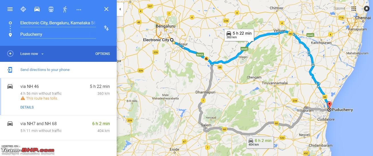
Hi me & my wife are planning to do a trip to
Pondicherry from Bangalore. When I check for the route on
Google Maps, I get two routes by default:
- Bangalore - Pondicherry (via Vellore-Ranipet-Vandavasi): 360 kms (5.5 hrs approx)
- Bangalore - Pondicherry (via Dharmapuri-Salem-Kallakurichi-Villupuram): 404 kms (6hrs approx)

But
Google ignores the most obvious route, which is also straight & saves distance by around 60 kms i.e.:
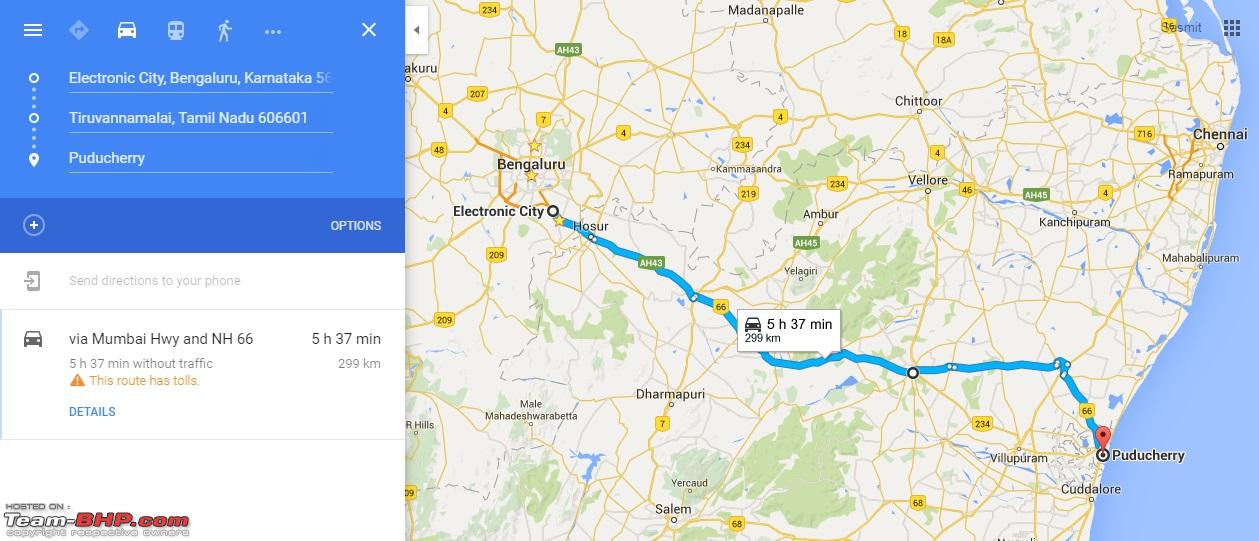
- Bangalore - Pondicherry (via Tiruvannamalai): 299 kms (5.5 hrs approx)
 Can anyone, who has travelled on this route via Tiruvannamalai, give me an update on road conditions, safety, etc.?
Thanks in advance :)
Quote:
Originally Posted by sasmitk
(Post 3978501)
But Google ignores the most obvious route, which is also straight & saves distance by around 60 kms i.e.:
[list][*]Bangalore - Pondicherry (via Tiruvannamalai): 299 kms (5.5 hrs approx)
|
Well if you think Google maps goofed up with this, read the last several pages of this thread and you will understand why :D
The NH 66 route via Krishnagiri-Tiruvannamalai is a route with small sections of good tarmac, rough ones and horrendous ones that can get you by surprise, some of the potholes are like craters!
Hence the preferred route these days is the one via Arcot-Vandavasi-Tindivanam bypasses, read up the previous posts and you can get exact details with landmarks. Even hotels and resorts in Pondicherry are now recommending the new route.
Quote:
Originally Posted by sasmitk
(Post 3978501)
Hi me & my wife are planning to do a trip to Pondicherry from Bangalore. When I check for the route on Google Maps, I get two routes by default:
|
The best route will be Via Hosur, Krishnagiri, Vaniyambadi, Vellore, Arcot, Cheyyar, Vandavasi and Tindivanam. Do not go via NH66 even though the road conditions are slightly better compared to what it was may be an year ago.
Quote:
Originally Posted by suresh_gs
(Post 3978587)
The best route will be Via Hosur, Krishnagiri, Vaniyambadi, Vellore, Arcot, Cheyyar, Vandavasi and Tindivanam. Do not go via NH66 even though the road conditions are slightly better compared to what it was may be an year ago.
|
Went 2 weeks ago and i can attest to this. Except for a small section of bad roads/speedbreakers/potholes in Cheyyar bypass(around 4kms) , the rest of the roads are quite good. Even though its small State Highways(after Arcot) the roads are good in general and you can get decent speeds and no unexpected potholes or craters. The best part is these State Highways are better designed in that you have bypass routes for all the towns so you wont encounter much traffic or waste much time.
Go for this route definitely. The extra 50 kms saves a lot of time which would be wasted if you take NH66.
Bangalore - Pondicherry (via Vellore-Ranipet-Vandavasi): 360 kms (5.5 hrs approx)
Quote:
Originally Posted by sasmitk
(Post 3978501)
But Google ignores the most obvious route, which is also straight & saves distance by around 60 kms i.e.:
Bangalore - Pondicherry (via Tiruvannamalai): 299 kms (5.5 hrs approx)
|
Pondy via Arcot - Cheyyar - Vandavasi is the in-practice primary route since several years now, as well as is google map's default route since years. Google map nowadays is quite up-to-date in terms of picking current in-practice primary route between major places. People who ignorantly take Tiruvannamalai route, mostly have frightful adjectives to describe the route :Shockked:
Hi, I am travelling from Bangalore to Pondicherry, Can anyone tell me how to divert from the NH towards the Cheyyar SH? Google maps shows a diversion before the Palar bridge. Is this correct?
Quote:
Originally Posted by sansvk
(Post 3994938)
Hi, I am travelling from Bangalore to Pondicherry, Can anyone tell me how to divert from the NH towards the Cheyyar SH? Google maps shows a diversion before the Palar bridge. Is this correct?
|
Look up this
post #640 and also post #446 by @vsbabu & post #453 by @J Ravi, you will have all the information you need for this route in very minute detail. :thumbs up
Quote:
Originally Posted by sansvk
(Post 3994938)
Can anyone tell me how to divert from the NH towards the Cheyyar SH?
|
Watch out for A2B on left while approaching Arcot(only A2B on NH46), post this point you shall be alert and may notice you are paralleling a river on your left and keep expecting
this prominent first junction where-in roads make a noticeable "Y". Key here is you don't have to curve left and go over the paralleling river and to prevent same take right at first possible bifurcation while nearing the junction. Taking this right go little further and spot a right which you have to eventually take maneuvering the U-turn illustrated in the map link. Pre-process the curves and branches of this junction from map in mind and vigilantly wait for it's superimposing realization to shortly arrive after A2B, is one way to prepare for it if suits you.
Quote:
Originally Posted by sansvk
(Post 3994938)
Hi, I am travelling from Bangalore to Pondicherry, Can anyone tell me how to divert from the NH towards the Cheyyar SH? Google maps shows a diversion before the Palar bridge. Is this correct?
|
Quote:
Originally Posted by Throtttle
(Post 3995062)
Watch out for A2B on left while approaching Arcot(only A2B on NH46), post this point you shall be alert and may notice you are paralleling a river on your left and keep expecting
|
+1 to Throttle. A2B Arcot is best landmark for locating the exit. If you start early, this is also good place to take your first break if you are OK to drive about 220km for your first break. Once you are past A2B, keep to your right. You will see exit marked for Tindivanam. I can see in Google its about 3km from A2B.
EDIT: In worst case, ultimate way to identify the exit is when you realize you are over the river bridge :D . No worries still, the U-turn in this case will be after the bridge and NH exit to the SH(on left while recovering back) will be easier this time :p
Quote:
Originally Posted by NPV
(Post 3994968)
Look up this post #640 and also post #446 by @vsbabu & post #453 by @J Ravi, you will have all the information you need for this route in very minute detail. :thumbs up
|
Thanks. I did go through these posts. Only query was google maps showing a new exit before the bridge.
Quote:
Originally Posted by ampere
(Post 3995093)
+1 to Throttle. A2B Arcot is best landmark for locating the exit. If you start early, this is also good place to take your first break if you are OK to drive about 220km for your first break. Once you are past A2B, keep to your right. You will see exit marked for Tindivanam. I can see in Google its about 3km from A2B.
|
Planning to start at 6.30 am and with a kid on board, the first stop would be at the A2B before Krishnagiri. The Arcot A2B would be the 2nd one, no further stops.
This was the exit I noticed on Google Maps and shall be adding this point to the GPS. Thank you.
Quote:
Originally Posted by Throtttle
(Post 3995098)
EDIT: In worst case, ultimate way to identify the exit is when you realize you are over the river bridge :D . No worries still, the U-turn in this case will be after the bridge and NH exit to the SH(on left while recovering back) will be easier this time :p
|
Thanks Throtttle, your earlier post was confirmation I wanted.
Just back from Pondicherry, the above mentioned route was near perfect. 90% good roads, rest 10% rough/ patched. The worst of the lot was the Cheyyar bypass.
Quote:
Originally Posted by sansvk
(Post 3999216)
Just back from Pondicherry, the above mentioned route was near perfect. 90% good roads, rest 10% rough/ patched. The worst of the lot was the Cheyyar bypass.
|
Yes, too many speed breakers too.
Even vandavasi bypass is bad for about 300 metres, after you take left turn from Cheyyar.
-Ravi
Planning to go to pondicherry via the conventional route, Bangalore - Pondicherry (Vellore-Ranipet-Vandavasi).
Can anyone list out the toll amounts on this journey?
Also what is the entry tax for commercial vehicles? (will be taking a hatch from myles most likely).
Thanks
| All times are GMT +5.5. The time now is 05:07. | |