Team-BHP
(
https://www.team-bhp.com/forum/)
NH 844 update from our recent trip to Sabarimala:
Onward - Saturday 14 Sep
Started from HAL at 7am and reached Attibele around 8:15 due to dense traffic. Not wanting to take a chance with NH 844, we planned to stay on the regular route via Krishnagiri, but changed our plan at Attibele.
Just after the flyover construction zone at Zuzuvadi, we turned right (SIPCOT Phase 1 on the left, BP bunk on right) and entered the Hosur ESI Ring Road. Drove on this road till Ashoka Pillar junction/circle and turned right to enter NH 844 (this is the old section of the Hosur-Rayakottai SH which is divided 4 lane without service roads) and goes via a part of Rayakottai town and eventually leads to the new 844 which is 4 laned with service roads. Excellent road with about 9 diversions mostly due to incomplete bridges and then we get to Dharmapuri bypass about 10Km before Sai Sangeet. This route is about 20Km shorter than the NH 44 via Krishnagiri and definitely saves time, especially given that there are 5 under construction flyovers between Hosur-Krishnagiri.
I would recommend taking this only during the day because the diversion signs are not very well marked and one may end up taking a section of the road that is blocked/incomplete somewhere up ahead.
Map Link Return - Monday 16 Sep
On Sunday afternoon, we started from Pampa, drove to Theni and stayed overnight.
Started from Theni on Monday at 8am after breakfast and managed to cross Attibele by 2:30pm again via NH 844 after Sai Sangeet.
In the return direction, I'm not sure how Gmaps would navigate to Bangalore along the incomplete section of NH 844 beyond Rayakottai without via points, especially around the other end of Rayakottai where NH 844 goes towards Denkanikottai.
On doing some experimentation, I found that it was trying to recommend the other end of Hosur ESI Ring road to merge with NH 44 (closer to Neralur side), but based on our onward journey, we decided to use the section of ESI Ring road which merges with NH 44 at Zuzuvadi and hence bypasses the road and flyovers of Hosur town on the NH 44 (I tried to trace our onward route in reverse direction). For this, I used
Ashoka Pillar in Hosur as a via point.
To Summarize - NH 844 is incomplete around the Sanamavu forest zone, Rayakottai town bypass and some Railway overbridges are not done yet.
Quote:
Originally Posted by NPV
(Post 5844589)
To Summarize - NH 844 is incomplete around the Sanamavu forest zone, Rayakottai town bypass and some Railway overbridges are not done yet.
|
My suggestion would be to use the external Hosur bypass (and not ESI). Go via TVS and there on to Kelamangalam which leads you directly to Rayakottai. From here get on to 844.
Quote:
Originally Posted by NPV
(Post 5844589)
In the return direction, I'm not sure how Gmaps would navigate to Bangalore along the incomplete section of NH 844 beyond Rayakottai without via points, especially around the other end of Rayakottai where NH 844 goes towards Denkanikottai.
On doing some experimentation, I found that it was trying to recommend the other end of Hosur ESI Ring road to merge with NH 44 (closer to Neralur side), but based on our onward journey, we decided to use the section of ESI Ring road which merges with NH 44 at Zuzuvadi and hence bypasses the road and flyovers of Hosur town on the NH 44 (I tried to trace our onward route in reverse direction). For this, I used Ashoka Pillar in Hosur as a via point.
|
I took this road on the same day, exited NH44 at Dharmapuri to join NH844 at 3:20PM and joined NH44 before Hosur at 4:50PM, via ESI ring road. Followed GMaps and the Attibelle route was slower as per Google. There was traffic where the road from Rayakottai joins the ring road, otherwise it was smooth roads all the way - the old SH is in good condition. Followed Gmaps and the navigation was accurate - taking through all the right diversions along the construction zone.
Quote:
Originally Posted by ampere
(Post 5844635)
My suggestion would be to use the external Hosur bypass (and not ESI). Go via TVS and there on to Kelamangalam which leads you directly to Rayakottai. From here get on to 844.
|
Hi Ampere, all,
I am planning the below route (coimbatore to attibelle) based on all the suggestions
Any thoughts?
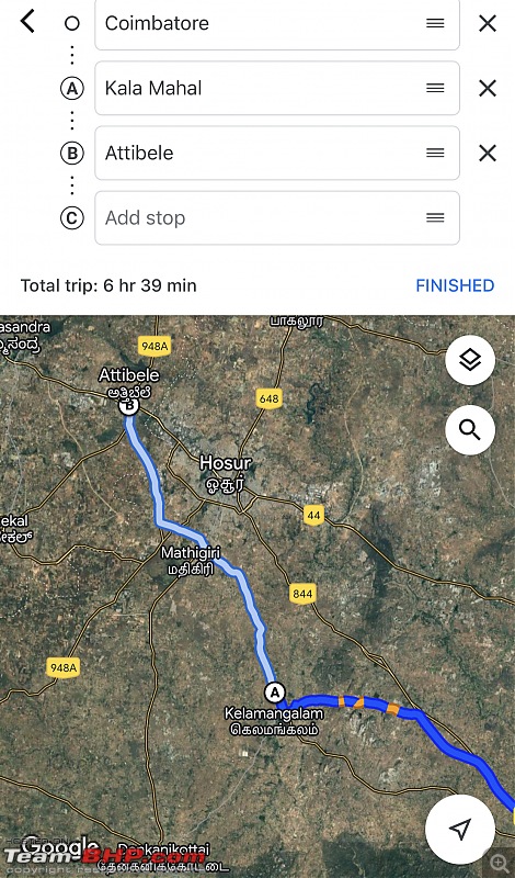
I see some railway under bridges etc mentioned, raising some concerns.
Quote:
Originally Posted by SideView
(Post 5845610)
Hi Ampere, all,
I am planning the below route (coimbatore to attibelle) based on all the suggestions
Any thoughts?
|
The route you show is correct till Kelamangalam. From here continue straight from the Kelamangalam cross. You will see roadworks and dversions. But it's still better. This road will take you to Rayakoattai which is where you intersect the 844.
I dont know how the Kelamangalam-Udanapalli road is and from there the status on 844 also I have no idea. You can try this and let us all know! :)
Quote:
Originally Posted by SideView
(Post 5845610)
I am planning the below route (coimbatore to attibelle) based on all the suggestions
I see some railway under bridges etc mentioned, raising some concerns.
|
I travelled this route this Monday and followed the Google suggestion. Usually I take Kelamangalam route, but this time I stayed on Rayakottai road and it has better alignment to NH844.
https://maps.app.goo.gl/RjSEMSRghYWYuRWd9
Attibele route was shown as delayed by 20 minutes, so I chose the one that joins before Hosur, via the ESI ring road.
This is the entire footage of the drive on NH844 stretch.
https://youtu.be/zwUIHAeBOXM
Quote:
Originally Posted by ampere
(Post 5845618)
The route you show is correct till Kelamangalam. From here continue straight from the Kelamangalam cross. You will see roadworks and dversions. But it's still better. This road will take you to Rayakoattai which is where you intersect the 844.
I dont know how the Kelamangalam-Udanapalli road is and from there the status on 844 also I have no idea. You can try this and let us all know! :)
|
I guess you misunderstood, i am travelling towards Attibele.
Quote:
Originally Posted by bejoy
(Post 5845629)
I travelled this route this Monday and followed the Google suggestion. Usually I take Kelamangalam route, but this time I stayed on Rayakottai road and it has better alignment to NH844.
|
Thanks bud, especially the video. Your suggestion shows a saving of 30 mins approx, will try it out.
Drove to Guruvayoor and back over the weekend.
Started from Bengaluru at 5 pm and took the below route
Bengaluru - Kanakapura - Malavalli - Kollegala - Hanur - Ramapura - Garikekandi - Baragur - Anthiyur - Gobichettipalayam - Coimbatore - Palakkad - Thrissur - Guruvayoor.
The road from Ramapura to Garikekandi is broken completely. Since I was travelling in the night decided to take this route. Was hoping that I would spot some elephant at least.. but could see only fresh dung on the way lol:
Was driving my Gypsy and honestly was enjoying the ride here. It is broken and there is actually no road at all. However did see a lot of private vehicles coming from opposite direction and surprisingly it was all KA registered.
Once you enter TN the road is brilliant all the way and I really enjoyed driving on this route.
Came across a lot of trucks on this route. During night they prefer this route as Dhimbam ghat is closed for all traffic from 09:00 pm to 06:00 am.
Reached Thrissur at 4 am and booked a hotel for the stay.
Had a great Darshan at Guruvayoor and then proceeded towards Kalady. It was not crowded and returned to Thrissur and stayed for the night
Started on 22nd Sep at 4 am and decided to come via Coimbatore - Sathyamangalam.
Reached Sathyamangalam at around 7:15 am and Dhimbam ghat was blocked as a bolero goods vehicle climbing the ghat had broken down leading to massive jam throughout the ghat.
People were driving all over resulting in blocks.
From Thalamarai took Germalam route and did really enjoy the forest route all the way to Vadeyarapalya.
Did a quick stop at Dondenaling and resumed my drive back.
As described in earlier posts the road is patchy for about ten kms between Dondenaling and Kollegala.
Kollegala - Malavalli - Kanakapura - Bengaluru was a breeze despite being a Sunday.
Overall the drive was about 1220 kms home to home.
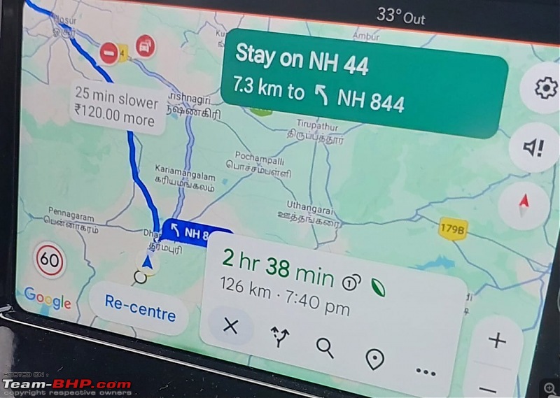
Rayakottai - Kelamangalam - Attibele:
During my recent drive, I took the Rayakottai - Kelamangalam route and joined directly at Attibele. It was fast till the initial 4L got over. Later I got stuck between a train of cars(at least 10 cars) on the 2L stretch before Rayakottai. This continued till the exit point of the Rayakottai town. From here I took the Kelamangalam route while all other cars in front of me took the hosur route. I felt that Kelamangalam route is more scenic than the other route and the traffic was less as well. Its a mix of 2L and divided road.
It took 1 hour and 25 minutes for me from the entry point at Dharmapuri till Attibele.
As per google maps, the
route via Krishnagiri was 25 minutes slower, probably because of Sunday evening traffic + congestion on those diversions.
Quote:
Originally Posted by arun_josie
(Post 5847983)
Rayakottai - Kelamangalam - Attibele:
During my recent drive, I took the Rayakottai - Kelamangalam route and joined directly at Attibele]2659162[/ATTACH]
|
How is the route condition and diversions between Rayakottai town exit and Kelamangalam and all the way till Attibelle via TVS Factory?
Is it good roads or still lot of diversions? Advisable to drive in night or better avoided?
-Ravi
Quote:
Originally Posted by ravib
(Post 5848311)
How is the route condition and diversions between Rayakottai town exit and Kelamangalam and all the way till Attibelle via TVS Factory? Is it good roads or still lot of diversions?
|
The road is good, not much diversions. There were more speed breakers as we got closer to Attibelle. I will prefer this route when compared to the Rayakottai - Hosur route.
Quote:
Advisable to drive in night or better avoided?
-Ravi
|
The traffic on this route is gradually increasing, so shouldn't be an issue till 10 PM at least.
Quote:
Originally Posted by arun_josie
(Post 5847983)
Rayakottai - Kelamangalam - Attibele:
[/ATTACH]
|
I kept Anthevadi checkpost as my intermediate point from Dharmapuri to Attibelle , but google maps/ network coverage royally screwed me over. It took me via 844 and was showing straight route but had no option to go straight as road was blocked and only option was detour via hosur.
Luckily traffic wasnt too bad I reach also within 1:30. Like you mentioned some stretch of two lane road if we get stuck behind trucks and tractors it is a pain.
So people using gmaps please be slightly careful.
Hi, I am thinking of taking the following route from Bangaloe to Coimbatore -( Bangalore - Anekal - Hosur Outer Bypass - Kelamangalam - Rayakottai - Dharmapuri Bypass - Salem - Coimbatore) on the morning of Deepavali around 4:30AM from Bangalore. I am wary of the Hosur-Krishnagiri traffic due to flyovers under construction. Is the NH844 option safe in the early morning before daylight?
Quote:
Originally Posted by kayarem
(Post 5867692)
Hi, I am thinking of taking the following route from Bangaloe to Coimbatore -( Bangalore - Anekal - Hosur Outer Bypass - Kelamangalam - Rayakottai - Dharmapuri Bypass - Salem - Coimbatore) on the morning of Deepavali around 4:30AM from Bangalore.
|
I am assuming you are referring Hosur Outer Bypass as Hosur ESI Ring Road. If yes, you need not to go to Kelamangalam. From Hosur Ring Road, you can go to Royakottai directly without going to Kelamangalam.
If you are starting 4:30 AM, I suggest you to check the traffic condition and take Hosur - Krishnagiri NH.
NH 844 is safe to take early morning. I have taken this road during late nights and early mornings. Be alert on the road diversions and speed breakers.
Good day everyone - how is the Bangalore - Kollegala (Sathyamangalam) - Coimbatore route especially after recent rains?
Planning a trip this weekend and the inputs would be super helpful.
Thanks
| All times are GMT +5.5. The time now is 19:10. | |

