Team-BHP
(
https://www.team-bhp.com/forum/)
- -
All Roads to Kerala
(
https://www.team-bhp.com/forum/route-travel-queries/27690-all-roads-kerala-627.html)
Quote:
Originally Posted by Rajeevraj
(Post 3939341)
Gudalur - Nilambur should be the best option. With roads in the forest repaired, should be a comfortable drive.
|
Quote:
Originally Posted by arjithin
(Post 3939347)
Gudalur route should be the shorter option. There are reports that the roads are repaired now. You should start around 4.30-4.45 AM so that you reach the checkpost just in time for the checkpost opening and can cover some distance in Kerala before traffic picks up. Similarly return you should plan to reach the checkpost before 9pm.
|
Thanks folks. Any leads on good vegetarian options en route? Planning to stop around Nilambur for lunch.
Quote:
Originally Posted by C300
(Post 3939839)
Thanks folks. Any leads on good vegetarian options en route? Planning to stop around Nilambur for lunch.
|
Not very sure about veg options, but I think it won't be that difficult to find good restaurants along your route.
If you start early you will cross Nilambur well before lunch.
Back after a short trip to Kerala. After a long time (nearly eight months gap) did the Kozhikode-Kuttiadi-Mananthavady-Bavali-Handpost-Mysore road route again. Left Kuttiadi by around 1045Hrs. One good thing is that the perennially bad sector of roads between Niravilpuzha and 4th Mile seems to have got patched up. 100 mts beyond Niravilpuzha bridge still seems to be in bad state, but after that things seems to have improved a lot.
There was minor traffic jam at Mananthavady and some rude surprises thrown by potholes between Mananthavady and Kaatikulam. But overall it was not really bad and steady pace could be maintained. The forest roads were also good, if the unmarked trouble some speed breakers in the KA state area can be ignored. By around 1315hrs we had safely crossed the forest area and took a break for 45mins to have our packed lunch. After a good spell of driving, a refreshing home cooked simple vegetarian meal, packed in plantain leaves (treated over slow fire) is very delicious ;).
We crossed Antharasanthe by around 1415Hrs and from then on there was a real increase in the number of vehicles. Two wheelers were more on the road and there were also a fair share of slow movers like tractor-trailers etc to add to the fun. By around 1500Hrs we hit the suburbs of Mysore city. A pleasant surprised awaited us; that was the new bye-pass from Nanjangud Rd to Bangalore Road. I found a junction from where the road goes to Bannur, but went straight ahead. Need to see if I can take the Bannur route next time, to join onto Kanakpura Road. By 1515Hrs we reaced the Columbia Asia hospital signal.
The entire pleasantness of the journey got screwed up big time after I took a right turn to the Mysore-Bangalore state highway :(. This road would soon become the equivalent of Varthur Road in Bangalore city limits. I was expecting a lesser number of vehicles, but that was not the case. So there I was one among a large battalion of cars and SUVs trying to find a steady pace and circumventing a wide variety of other vehicles. Two wheelers (especially long distance bikers) who try to squeeze in between your legs if they find enough gap out there on one hand, and on the other hand there were the tractor trailer, goods auto rickshaw brigade who went on the right side of the road at a leisurely pace. Two national permit trucks (going at 25kmph and 27kmph respectively), trying to overtake each other was the bonus part of the deal. Every major junction had traffic piling up, and if it was towns like Mandya, Channapatna & Ramanagara things were even worse. Pedestrians considering this state highway as a local bazaar street gave an impression that expect for the car drivers every one else had a good relaxed life style out there. It was when patiently waiting at these places that I found the similarity with Varthur Road.
At around 1730Hours I reached the NICE road toll booth. The queue luckily was not really that long, and without further surprises by around 1830Hrs pulled into "home sweet home".
Summary: Will now research on using the Bannur Road to reach Malavalli where I join to the Kanakpura road. Mysore-Bangalore state highway seems to be getting more messier.
Added later: Saw all the expert advice on the Nilambur-Nadugani route. Thanks for that. I could not try that route, as I had some other pickups to be done from Kozhikode side.
Quote:
Originally Posted by sachinpk
(Post 3940368)
Summary: Will now research on using the Bannur Road to reach Malavalli where I join to the Kanakpura road. Mysore-Bangalore state highway seems to be getting more messier.
|
Another option may be:
Handpost-Nanjangud-T Narasipura-Malavalli. (I think Binand tried it once. Check with him).
The railway over bridge at Angadippuram has finally opened! clap:
Man, this was a major bottleneck in this route when the railway gate is closed.
Quote:
Originally Posted by sachinpk
(Post 3940368)
the new bye-pass from Nanjangud Rd to Bangalore Road. I found a junction from where the road goes to Bannur, but went straight ahead. Need to see if I can take the Bannur route next time, to join onto Kanakpura Road.
Summary: Will now research on using the Bannur Road to reach Malavalli where I join to the Kanakpura road. Mysore-Bangalore state highway seems to be getting more messier.
|
I had reported the completion of the final arc of the MRR in the Bangalore-Calicut thread.
The Mysore-Bannur-Malavally-Kanakapura-Bangalore route can be taken to avoid the mess on NH 275, but be aware the final Kanakapura-Bangalore stretch of this route is also hell during normal hours, with heavy traffic and bad drivers around. There have been times it has taken me 2 hours to cover this approx. 50 km distance.
I now time my arrival at Bangalore before lunchtime on Sundays. Only way to have a pleasant driving experience.
Quote:
Originally Posted by ampere
(Post 3940425)
Handpost-Nanjangud-T Narasipura-Malavalli. (I think Binand tried it once. Check with him).
|
Handpost-Begur-Nanjangud is unnecessarily circuitous; I think you mean Handpost-Hampapura-Nanjangud. This route has no road for about 1 km. If one can survive that it is a good alternative to connect from SH 33 to NH 209.
Quote:
Originally Posted by Gannu_1
(Post 3940490)
The railway over bridge at Angadippuram has finally opened! Man, this was a major bottleneck in this route when the railway gate is closed.
|
I saw a report that there was a traffic jam on the overbridge on day 1 itself. It seems the approach road (NH 213) on either side is of 30m width while the bridge itself is only 7.5m wide. Plus the way traffic is routed, traffic from south-side of the NH going to Perinthalmanna has to go westwards on the NH and take a U-turn. So the conclusion was that the bridge would do nothing the ease traffic in Angadippuram.
Quote:
Originally Posted by binand
(Post 3940510)
Handpost-Begur-Nanjangud is unnecessarily circuitous; I think you mean Handpost-Hampapura-Nanjangud. This route has no road for about 1 km. If one can survive that it is a good alternative to connect from SH 33 to NH 209.
|
Yes I did mean Hampapura option. So looks like no change to that road condition.
Quote:
Originally Posted by Gannu_1
(Post 3940490)
The railway over bridge at Angadippuram has finally opened! clap:
Man, this was a major bottleneck in this route when the railway gate is closed.
|
Yeah, this is a big welcome relief to this stretch. A long awaited one.clap:
Not a rare sight to see 1km+ long queues when the railway gate was closed.
The new bridge also brings along with it few concerns because of the developments in this part of the stretch in the recent past (1) and expected for the near future (2).
1: A major portion of the stretch between Perinthalmanna and Angadippuram is already made into a 4 laned one, very busy with vehicles as well as shops dotted on both its sides and this 2 laned bridge will fast become a bottle neck itself because of the lack of for-sightedness :Frustrati(or so called difficulty in making land available) to make it a broader one in fist place.
2. The NH213 (new: 966?) highway itself (I think I have read reports) has ongoing plans to soon become 4 laned.
During my last drive from Tirurangadi to Aluva, took the Puthanathani - Thirunavaya Railway Over-bridge - Kuttippuram road.
- Two lane road with proper lane markings, excellent surface and minimal traffic.
- You can avoid many bottlenecks and heavy traffic in the conventional route (say, Vattapara, Valanchery Town for instance
- Watch out for the rumble strips (though the strips are painted over, there are no proper warning sign boards and may come as a surprise)
- And as BHPian
denver85 pointed out, this route also serves as a option to avoid the busy Parappanangadi - Tanur - Tirur road and hit Chamravattom route directly at BP Angadi
- Toll is Rs 5 (one way) and Rs 7.5 (two way). Dad didn't have to pay the toll last two times while he passed by the toll both around 10 PM
Puthanathani - Thirunavaya Railway Over-bridge - Kuttippuram road :
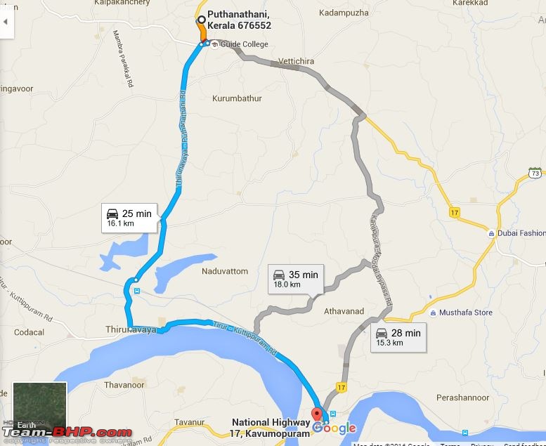
Puthanathani - BP Angadi :

Another update :
Road resurfacing work going on in Ramanattukara - Thondayad Bypass.
Yesterday early morning (around 7 AM), I lost few minutes near Copper Folia during my onward drive. Expect a delay of minutes to hours considering the heavy traffic
Quote:
Originally Posted by Klub Class
(Post 3940714)
During my last drive from Tirurangadi to Aluva, took the Puthanathani - Thirunavaya Railway Over-bridge - Kuttippuram road.
|
Thank you. Will try out this during my trip for Vishnu. I am driving TCR- CLT route for more than 20 years now, never knew about this option.
People taking U-turns to and from the Angadippuram RO bridge is blocking the traffic else the movement is smooth. Faced no issues at 7 AM and 5:30 PM today.
Quote:
Originally Posted by Klub Class
(Post 3940714)
Another update :
Road resurfacing work going on in Ramanattukara - Thondayad Bypass.
Yesterday early morning (around 7 AM), I lost few minutes near Copper Folia during my onward drive. Expect a delay of minutes to hours considering the heavy traffic
|
Major block here around noon. We were stuck for almost 20 mins in a standstill traffic. Really pathetic to see the resurfacing being done with minimal manpower. We saw barely 5-6 men working. :Frustrati
Quote:
Originally Posted by sachinpk
(Post 3940368)
The forest roads were also good, if the unmarked trouble some speed breakers in the KA state area can be ignored. By around 1315hrs we had safely crossed the forest area and took a break for 45mins to have our packed lunch.
|
If I'm not mistaken there is now a diversion on this route and the complete route through the forest is no longer allowed to vehicles, right? Does the diversion have good roads?
BTW, are you the same Sachin from BRF?
Quote:
Originally Posted by Kartik Kumar
(Post 3943747)
If I'm not mistaken there is now a diversion on this route and the complete route through the forest is no longer allowed to vehicles, right? Does the diversion have good roads?
|
Right. There is a bypass road through a bunch of small villages that avoid some part of the WLS, which is of quite good quality. If you are interested in this route, you should read the Bangalore-Calicut thread where it is discussed very frequently and status updates are most recent.
Quote:
Originally Posted by binand
(Post 3943757)
If you are interested in this route, you should read the Bangalore-Calicut thread where it is discussed very frequently and status updates are most recent.
|
Which is that new route sir? You are also talking about the Mysore->Handpost->
few villages->short forest stretch->Baavali->Kaatikulam->Manathavady route only, right?
How much time does it take to drive from Cochin to Trivandrum(Final destination is Nagercoil(Kanyakumari)? Plan is to start from Cochin around 4:00/5:00 AM.
Also, google shows 2 routes, through Alapuzha and one through Kottayam. Which is the recommended route?
| All times are GMT +5.5. The time now is 22:16. | |

