Team-BHP > Travelogues > Route / Travel Queries
Register New Topics New Posts Top Thanked Team-BHP FAQ


Reply
  Search this Thread
12,372 views
Old 3rd November 2009, 21:42   #1
Senior - BHPian
 
anekho's Avatar
 
Join Date: Dec 2008
Location: .
Posts: 1,995
Thanked: 684 Times
Map contradictions - where is NH207?

Major issue here guys.

I have been looking for NH207 on several maps and I am completely confused about it's location. Might sound funny but it's not.

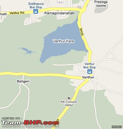
I am attaching snaps of two maps, which one is correct!?!

The first one says the road connecting to varthur road is nh207:

Name:  Screen shot 20091103 at 5.04.28 PM.png
Views: 4875
Size:  159.6 KB

The second one says the road connecting to varthur road is sh35!

Name:  Screen shot 20091103 at 5.11.43 PM.png
Views: 4079
Size:  48.9 KB

Or are they the same road with different names?

Some one please help asap
anekho is offline  
Old 3rd November 2009, 22:31   #2
Senior - BHPian
 
mjothi's Avatar
 
Join Date: Dec 2007
Location: Bangalore
Posts: 3,287
Thanked: 231 Times

Quote:
Originally Posted by anekho View Post
Major issue here guys.

I have been looking for NH207 on several maps and I am completely confused about it's location. Might sound funny but it's not.

I am attaching snaps of two maps, which one is correct!?!

The first one says the road connecting to varthur road is nh207:

Attachment 221205

The second one says the road connecting to varthur road is sh35!

Attachment 221206

Or are they the same road with different names?

Some one please help asap
Yes both are correct. I think I have seen both marking in this stretch

And asked same question in this same forum
mjothi is offline  
Old 4th November 2009, 15:26   #3
Senior - BHPian
 
anekho's Avatar
 
Join Date: Dec 2008
Location: .
Posts: 1,995
Thanked: 684 Times

Thanks for the reply mjothi, but i am still completely confused!

If sh35=nh207, what is the nh207 in this map?

Name:  Screen shot 20091104 at 10.54.43 AM.png
Views: 4745
Size:  107.6 KB
anekho is offline  
Old 4th November 2009, 19:20   #4
BHPian
 
sureshurs's Avatar
 
Join Date: Jan 2008
Location: Bangalore
Posts: 139
Thanked: 51 Times

The second map is correct. Varthur Road connects to SH35 (Attibelle to -Sarjapur-Hoskote). We can reach NH207 from SH35 at multiple points -

1. NH4 between Whitefield deviation and Hoskote Jn
2. Hope Farm Jn and NH207 ( on the way to Mallur)
3. Sarjapur

I have travelled to Kolar through Hopefarm Jn and NH207 twice and also from Sarjapur Road NH207.
sureshurs is offline  
Old 4th November 2009, 19:48   #5
Senior - BHPian
 
trrk's Avatar
 
Join Date: Feb 2004
Location: Alleppey, Kerala
Posts: 2,114
Thanked: 34 Times

Hi,

Source: Wikipedia

SH 35 Sidlaghatta - Hoskote - Kadagodi - Anekal - 89 kms

NH 207 Hosur Tamilnadu- Sarjapur - Devanahalli - Doddaballapur - Nelamangala - 135 kms

No idea bout the maps, though!
trrk is offline  
Old 4th November 2009, 20:05   #6
Senior - BHPian
 
mjothi's Avatar
 
Join Date: Dec 2007
Location: Bangalore
Posts: 3,287
Thanked: 231 Times

Quote:
Originally Posted by anekho View Post
Thanks for the reply mjothi, but i am still completely confused!

If sh35=nh207, what is the nh207 in this map?

Attachment 221784
Now confusion should be clear. It may be mistake in other 2 maps you put. The last one you put is right.

When you are coming from Attibelle, after sarjapur police station you will have a round about. If you take right, it is NH207. If you take left it is SH35.

Hope this clears.
mjothi is offline  
Old 4th November 2009, 20:27   #7
BHPian
 
Govinda-Govinda's Avatar
 
Join Date: Aug 2009
Location: Bangalore
Posts: 52
Thanked: 0 Times

Had been to Chikka Tirupati on Nov1 2009. It is on NH207.
Govinda-Govinda is offline  
Old 4th November 2009, 21:00   #8
Senior - BHPian
 
anekho's Avatar
 
Join Date: Dec 2008
Location: .
Posts: 1,995
Thanked: 684 Times

Thanks for the info guys just to clarify completely, the following map is correct right?

Name:  Screen shot 20091104 at 10.54.43 AM.png
Views: 3194
Size:  107.6 KB

Also, could someone please comment on the road condition of nh207?
How long does it take to reach Whitefield from Chikkatirupathi?
anekho is offline  
Old 4th November 2009, 21:37   #9
BHPian
 
sureshurs's Avatar
 
Join Date: Jan 2008
Location: Bangalore
Posts: 139
Thanked: 51 Times

The map is the right one.

It takes 25-30 mins from whitefield Hope Farm Jn. The road is good in patches
sureshurs is offline  
Old 4th November 2009, 22:12   #10
Team-BHP Support
 
ampere's Avatar
 
Join Date: Sep 2009
Location: Bangalore
Posts: 17,950
Thanked: 12,936 Times

If you have been to Sarjapur, through the regular Sarjapur road, you will see that there is a bypass (very-very bad mud road) after the Bus-stand. If you go through this and pass beyond Sarjapur, you would see a Y junction. This the NH207. One goes towards Chikka Tirputhi and Hope Farm, Hoskote, Devenhalli. The other side (South) goes towards Bagalur. This is also has a State crossing. At Bagalur, you hit a T-junction. Left leads to Malur, while the right goes to Hosur (about 8 km).

Originally when the airport was shifted, and traffic increased on the ORR, this road was tipped to be the replacement for diverting all truck traffic from Hyderabad to Hosur. Some how this did not materialize. Also the road has many pot holes. Once entering TN side near Bagalur, this road is good.

It was a good alternative to bypass the Electronic City Traffic, when construction was in full swing. Now it may not be needed.
ampere is offline  
Old 4th November 2009, 22:29   #11
BHPian
 
Join Date: Aug 2006
Location: mumbai
Posts: 29
Thanked: 2 Times

Can any one tell me what does AH stands for
NH = National Highway
SH = State highway
AH = ?
dhananjay is offline  
Old 5th November 2009, 18:34   #12
Senior - BHPian
 
Join Date: Jul 2006
Location: Bangalore
Posts: 2,256
Thanked: 37 Times

Ok thats strange one for sure.

Regards,

Ravi.
ravibhat is offline  
Old 5th November 2009, 18:49   #13
Senior - BHPian
 
mjothi's Avatar
 
Join Date: Dec 2007
Location: Bangalore
Posts: 3,287
Thanked: 231 Times

Quote:
Originally Posted by dhananjay View Post
Can any one tell me what does AH stands for
NH = National Highway
SH = State highway
AH = ?
It may be Asian Highway? Where did you see this?
mjothi is offline  
Old 5th November 2009, 18:52   #14
BHPian
 
Join Date: Aug 2006
Location: mumbai
Posts: 29
Thanked: 2 Times

Quote:
Originally Posted by mjothi View Post
It may be Asian Highway? Where did you see this?
I have seen this after crossing Dhule, while going towards Nagpur
dhananjay is offline  
Old 5th November 2009, 19:02   #15
Senior - BHPian
 
mjothi's Avatar
 
Join Date: Dec 2007
Location: Bangalore
Posts: 3,287
Thanked: 231 Times

Quote:
Originally Posted by dhananjay View Post
I have seen this after crossing Dhule, while going towards Nagpur
Then yes. check this out.

Asian highways (Road numbering systems)
mjothi is offline  
Reply

Most Viewed


Copyright ©2000 - 2024, Team-BHP.com
Proudly powered by E2E Networks