Team-BHP > Travelogues > Route / Travel Queries
Register New Topics New Posts Top Thanked Team-BHP FAQ


Reply
  Search this Thread
3,811,981 views
Old 14th October 2010, 01:05   #2611
Newbie
 
jjains's Avatar
 
Join Date: Dec 2009
Location: Bangalore
Posts: 14
Thanked: 0 Times
Blr - hassan - Belur / Halebidu - Mudigere - Dharmasthala - Venur - Moodabidri -...

Folks,

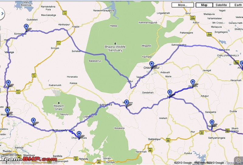
There is a long weekend coming up - Fri.15th, 16th and 17th Oct. Idea is to cover most of Jain temples between Bangalore and Mangalore.

The route I am following is:
Blr - hassan - Belur / Halebidu - Mudigere - Dharmasthala - Venur - Moodabidri - Karkala - Agumbe - Chikmagalur - Arsikere - Tiptur - Tumkur - Bangalore.

I will start from Bangalore in the evening of Thursday and stay at Shravanbelgola for a night. Next 2nd planned night halt is at Dharmashtala.
Question is about 3rd night halt - How is Agumbe? Any decent stay facilities there? I have read about it and hope to see good greenery there, visit nearby good places and relax!

I will be self driving in my Swift DZire with my wife and parents. We will be carrying food / water with us, as my parents do eat only Jain food / prepared with utter cleanliness!

This is the route map from Google. Please provide comments, advises
* If this is good route and if in some sections roads are bad, should we take any other road?
* Question about third night stay. Is it possible at Augmbe? Any suggestions?
* How is NH48 from Nelmangala to Hassan? This is where I will leave NH48.

The art of travelling between Bangalore - Mangalore/Udupi-3jpeg.jpg
The art of travelling between Bangalore - Mangalore/Udupi-2jpeg.jpg

Please reply.

Thanks.
jjains is offline  
Old 14th October 2010, 02:22   #2612
BHPian
 
Join Date: Aug 2008
Location: Bangalore
Posts: 63
Thanked: 36 Times
Bangalore-Kollur Road Condition

Friends,

I will be travelling from Bangalore to Kollur (Mookambika Temple) this weekend. I plan to take this route:

Blr-Tumkur-Arsikere-Shimoga-Ayanur-Ripponpet-Hosanagara-Nagara-Nittur-Kollur

How is the road condition of this stretch? I did see a few updates from earlier this year (courtesy @vasoo & @motomaverick), but wanted to know the latest state of affairs after the rains...
civicsense is offline  
Old 14th October 2010, 10:54   #2613
Senior - BHPian
 
sushrutha's Avatar
 
Join Date: Mar 2006
Location: Chikmagalur/Ban
Posts: 1,703
Thanked: 333 Times

Quote:
Originally Posted by jjains View Post
Folks,


Blr - hassan - Belur / Halebidu - Mudigere - Dharmasthala - Venur - Moodabidri - Karkala - Agumbe - Chikmagalur - Arsikere - Tiptur - Tumkur - Bangalore.

- How is Agumbe? Any decent stay facilities there? I have read about it and hope to see good greenery there, visit nearby good places and relax!

I will be self driving in my Swift DZire with my wife and parents.
* If this is good route and if in some sections roads are bad, should we take any other road?
* Question about third night stay. Is it possible at Augmbe? Any suggestions?
* How is NH48 from Nelmangala to Hassan? This is where I will leave NH48.
There isn't much of staying options in Agumbe.
I would suggest you to Either return to Sringeri & stay ( hradly 25kms)
Or stay at Shimoga/Theerthally.

Road condition between Hariharpura - Balehonnur is not in very good condition, but managable with DZire.

NH48 Between Nelmangala - Kunigal-Bellur cross, I wouldn't say it's too good. But too much of Speed breakers+ road humps & some stretch befor and after Kunigal is filled with potholes.

Quote:
Originally Posted by civicsense View Post
Friends,

Blr-Tumkur-Arsikere-Shimoga-Ayanur-Ripponpet-Hosanagara-Nagara-Nittur-Kollur

How is the road condition of this stretch?
This is the shortest route to Kollur from Bangalore.
BLR-Shimoga-Ayanur is in good condition, but from here on till Nittur is not in a very good state due to Monsoon, some part of the stretch is good, some part is with potholes + rough road.

Last edited by sushrutha : 14th October 2010 at 10:57.
sushrutha is offline  
Old 14th October 2010, 11:17   #2614
BHPian
 
Join Date: Aug 2008
Location: Bangalore
Posts: 63
Thanked: 36 Times

Thanks @sushrutha. I dont have high hopes of the Ayanur-Kollur section. Hope it isnt too bad. Will post a report on Monday with the status.
civicsense is offline  
Old 14th October 2010, 16:50   #2615
BHPian
 
Join Date: Jan 2010
Location: Bangalore
Posts: 123
Thanked: 6 Times

Just back from Saligrama (near Kundapura). I took the following route while going . Bangalore -> Tumkur-> gubbi -> Arsikere -> Shimoga -> Jog falls -> Kargal -> Linganmakki -> Kollur -> Kundapura -> Saligrama.

Bangalore to Tumkur is a breeze. To go to Gubbi from there, you can either take a bypass road or go inside Tumkur town and then to Gubbi. I took the bypass road and it is is very bad shape.

But after you touch the Highway, the road is in good condition. The stretch between Birur and Tarikere is average, there are a lot of surprise pot holes so you got to keep your speed with in reasonable limit. About one KM stretch after Birur is extremely bad so be careful. Again after Tarikere till Shimoga the road is in good condition.

Shimoga to Jog falls, the road is average with few bad patches, but motorable.

From Jog to Kollur we went via Kargal and Linganmakki (Not via Bhatkal).
Check this out:

My Saved Places - Google Maps

Till Kollur this road is not in very good condition. Though there are no pot holes, but the surface is depleted. You can easily maintain a speed of 40-50kmph. If you ever happen to take this route to kollur from jog falls make sure that you take during day time only. This road passes through forest area and has hardly any, so called villages on the way. You might even find it difficult to find a human being to ask for the directions. There are remote houses here and there, and that's it. And if your vehicle needs repair, its very difficult to find any help in the middle of the forest.

After Linganmakki, I could have gone to Bhatkal and taken the highway or the above route. On the highway the big craters would have gobble my car and on the route above probably some wild animals would have eaten me up. I preferred to be eaten up by wild animals rather than by the huge craters on the highway, and I am glad I chose this option.

Kollur onwards the road is good. I wanted to join the NH 17 near kot high school as suggested in this thread. But somewhere I missed the turn towards Halady and landed up few KMs before Kundapura. Drive from there till Kundapura is anybody's nightmare with huge pot holes. Kundapura onwards the road condition is decent.

While comming back I took this route:

Saligrama -> Brahmavara -> Hebri -> Agumbe -> Thirthalli -> Shimoga -> Bangalore

Till The beginning of Agumbe ghat the road is mostly in good condition. Agumbe ghat is also motorable though not in best of the conditions. Agumbe onwards its a breeze. The local roadside vendor (thele wala) at the sunset point in Agumbe ghat mentioned that 3 months from now the ghat road will be closed for a year or so for road widening. Is this good news? Well may be yes or may be not. Agumbe forest is a very sensitive ecological area. Wide roads means more vehicles, bigger vehicles. And it means more pollution. I think repairing the road is enough.
vnk77 is offline  
Old 15th October 2010, 00:43   #2616
BHPian
 
lazybrain's Avatar
 
Join Date: Oct 2010
Location: Bangalore/Mangalore
Posts: 223
Thanked: 122 Times
Hello Guys!!

Hello Guys.

I am a newbie on Team-BHP and would like to inaugurate with my first post on this thread since i am following this thread from a very long time. I traveled last month Bangalore to Mangalore and i felt Bangalore - Hassan - Belur - Charmadi - Belthangady is a far better route than shiradi ghat. The distance is approximately 370 kms which is around 30 kms more than shiradi route but its worth taking that route. Please note that i took this route on Sept 15th and some of you might have more information on current scenario since i believe road conditions on NH-48 deteriorate on daily basis and everyday is a new information!!
lazybrain is offline  
Old 15th October 2010, 04:46   #2617
BHPian
 
Join Date: Aug 2008
Location: Bangalore
Posts: 63
Thanked: 36 Times

Thanks @vnk77. that is useful information.

I will be wary of the bad roads you mentioned. We are leaving in another 30min. Just thought I'd check for any more updates on this route. Good that I did.
civicsense is offline  
Old 15th October 2010, 10:44   #2618
Senior - BHPian
 
sushrutha's Avatar
 
Join Date: Mar 2006
Location: Chikmagalur/Ban
Posts: 1,703
Thanked: 333 Times

Quote:
Originally Posted by vnk77 View Post
Agumbe ghat , 3 months from now the ghat road will be closed for a year or so for road widening. Is this good news?
Yes the road widening will take place in coming months. I cant comment on the road widening + ecological impact.
Agumbe road was cemeted by Britishers, some part of the road is still in good condition which was built ~100 years ago.

OT.
Suppose I stay in Theerthally, What are my options to reach Hebri when the Agumbe ghat road is closed ?
sushrutha is offline  
Old 15th October 2010, 10:59   #2619
BHPian
 
Join Date: Jan 2010
Location: Bangalore
Posts: 123
Thanked: 6 Times

Quote:
Originally Posted by sushrutha View Post
Yes the road widening will take place in coming months. I cant comment on the road widening + ecological impact.
Agumbe road was cemeted by Britishers, some part of the road is still in good condition which was built ~100 years ago.

OT.
Suppose I stay in Theerthally, What are my options to reach Hebri when the Agumbe ghat road is closed ?
Wow, 100 years old road in better condition than less than a year old road !!!

You can probably to go Thirthalli -> Koppa -> Harihar pura -> Someshwarama -> Hebri. I am not sure of the road condition though.
vnk77 is offline  
Old 15th October 2010, 11:27   #2620
Senior - BHPian
 
sushrutha's Avatar
 
Join Date: Mar 2006
Location: Chikmagalur/Ban
Posts: 1,703
Thanked: 333 Times

Quote:
Originally Posted by vnk77 View Post
Wow, 100 years old road in better condition than less than a year old road !!!

You can probably to go Thirthalli -> Koppa -> Harihar pura -> Someshwarama -> Hebri. I am not sure of the road condition though.
Thanks, I'm not talking abt the road condition here.
Hariharpura - Someshwara, is there any route ? But this route will be pretty much longer.
Other options is
1 Theerthally - Hosnagara-Hulikal - Hebri
sushrutha is offline  
Old 15th October 2010, 11:33   #2621
BHPian
 
Join Date: Jan 2010
Location: Bangalore
Posts: 123
Thanked: 6 Times

Quote:
Originally Posted by sushrutha View Post
Thanks, I'm not talking abt the road condition here.
Hariharpura - Someshwara, is there any route ? But this route will be pretty much longer.
Other options is
1 Theerthally - Hosnagara-Hulikal - Hebri
Thats even longer route. Hosnagar is almost NNW of Thirthalli and Hulikal is almost West, so you are taking a much longer router there.

I still think Koppa to Someswara will be shorter. You can look up google map to get the idea about where these places are located.
vnk77 is offline  
Old 15th October 2010, 12:10   #2622
Senior - BHPian
 
sushrutha's Avatar
 
Join Date: Mar 2006
Location: Chikmagalur/Ban
Posts: 1,703
Thanked: 333 Times

Quote:
Originally Posted by vnk77 View Post
Thats even longer route. Hosnagar is almost NNW of Thirthalli and Hulikal is almost West, so you are taking a much longer router there.

I still think Koppa to Someswara will be shorter. You can look up google map to get the idea about where these places are located.
@VNK, I know the places. I'm from almost that part of world .
But can you give me the exact road map from Hariharpura - Someshwara. Are you talking about Hariharpura - Sringeri- SK Border-Karkala-Hebri route ? If yes, This route also be pretty much longer.
I'm interested to know the nearest route map from Theerthally-Someshwara when Agumbe ghat will be closed.
sushrutha is offline  
Old 15th October 2010, 12:22   #2623
Team-BHP Support
 
Samurai's Avatar
 
Join Date: Jan 2005
Location: Bangalore/Udupi
Posts: 25,828
Thanked: 45,518 Times

I don't think there is any closer alternate route than Hulikal ghat or Kudremukh ghat. If there was, we would know it already.

Let's not consider trekking paths or air-glider paths.
Samurai is offline  
Old 15th October 2010, 12:40   #2624
Senior - BHPian
 
sushrutha's Avatar
 
Join Date: Mar 2006
Location: Chikmagalur/Ban
Posts: 1,703
Thanked: 333 Times

Quote:
Originally Posted by Samurai View Post
I don't think there is any closer alternate route than Hulikal ghat or Kudremukh ghat. If there was, we would know it already.

Let's not consider trekking paths or air-glider paths.
I was waiting for your reply Samurai san,
But to travel (~10 km ) Agumbe - Someshwara , now it's almost a round trip of 80kms ..
Via Hulikal ghat should be the less distance road.
sushrutha is offline  
Old 15th October 2010, 12:46   #2625
Senior - BHPian
 
addyhemmige's Avatar
 
Join Date: Dec 2008
Location: Bangalore/Hassan
Posts: 1,527
Thanked: 487 Times

Quote:
Originally Posted by vnk77 View Post
Wow, 100 years old road in better condition than less than a year old road !!!

You can probably to go Thirthalli -> Koppa -> Harihar pura -> Someshwarama -> Hebri. I am not sure of the road condition though.
If I'm not mistaken, the route from Hariharapura to Someshwara has to pass through Agumbe ghats. AFAIK, The only other route is through Sringeri-SK Border-Karkala-Hebri-Someshwara. I think this will be very long. Is this the route you are talking about?

Quote:
Originally Posted by vnk77 View Post
After Linganmakki, I could have gone to Bhatkal and taken the highway or the above route. On the highway the big craters would have gobble my car and on the route above probably some wild animals would have eaten me up. I preferred to be eaten up by wild animals rather than by the huge craters on the highway, and I am glad I chose this option.
How is the road condition on this route? Where do you deviate near Linganamakki to Kollur?

Quote:
The local roadside vendor (thele wala) at the sunset point in Agumbe ghat mentioned that 3 months from now the ghat road will be closed for a year or so for road widening. Is this good news? Well may be yes or may be not. Agumbe forest is a very sensitive ecological area. Wide roads means more vehicles, bigger vehicles. And it means more pollution. I think repairing the road is enough.
I think just repairing the road should suffice. Road widening allows bigger vehicle and more heavy truck/bus traffic. Who knows, even mine truck might start using this route then

Quote:
Originally Posted by sushrutha View Post
Thanks, I'm not talking abt the road condition here.
Hariharpura - Someshwara, is there any route ? But this route will be pretty much longer.
Other options is
1 Theerthally - Hosnagara-Hulikal - Hebri
I guess the better option will be Hulikal ghat. I don't think you need to go to Hosanagara. There is a road from Thirthally to Nagara. I don't know how good that road is, but, it should be a lot shorter. Better get a jeep instead of a Civic

Last edited by addyhemmige : 15th October 2010 at 12:54.
addyhemmige is offline  
Reply

Most Viewed


Copyright ©2000 - 2024, Team-BHP.com
Proudly powered by E2E Networks