| |||||||

| Search Forums |
| Advanced Search |
| Go to Page... |
 |
| Search this Thread |  121,874 views |
 19th July 2011, 14:59
| #1 |
| BHPian Join Date: Jun 2011 Location: New Delhi
Posts: 207
Thanked: 419 Times
| Travelogue: A family trip across Kinnaur and Spiti Disclaimer: This is my travelogue I have ever written. Please excuse the writing skills. The plan to do the family trip to Spiti-Lahaul trip originated from a promise to my 7year old daughter. I had promised her that this summer vacation I will help her to get some rare fossils for her Summer holidays project and show her Glacier, Snow and possible snowfall. I had traveled alone in the past as I did not know how my kids will handle long road trips on Mountains. This plan germinated to a family trip across Kinnaur, Spiti and Lahaul. We family of four me, wife and 2 kids (4 year old son and 7 year old daughter) planned the trip for last week of May. The departure date kept on moving ahead in hope of reaching Manali from kaza via Kunzum and Batal thereby completing the loop. I had an impending business tour on 20th June from Delhi which could not be postponed. I had been in phone with HPPWD officials at Kaza, Keylong, Khoskar as well as Lotey (owner of Hotel Spiti Sarai and Spiti adventure at Kaza getting updates about road clearing work being undertaken for Kaza-Manali Road. The tentative dates kept on shifting from 10th June to 15th June and finally to 20th June for the clearing up of glaciers from Gramphoo-Chotta Dhara stretch. In the meantime, I met HP tourism officials in Delhi regarding route conditions and other facility. I was discouraged by them to go beyond kalpa with my Kids. I was told the danger of high altitude and AMS, lack of medical facilities and lack of proper lodging and hotel facilitates. I was reminded about the remoteness of the place. I was disheartened and got overpowered by fear for kids especially since my daughter suffers from Asthmatic bronchitis . I called up various people in Spiti and Kinnaur to solicit there advice. Owner of Rupin River Resort at Rakchham thought that it would be my foolishness to take my Kids upto Kaza and to do the Kaza Manali road. From some I got somewhat positive response. Very few were willing to tell me to not to worry about my daughter's health. I guess as the matter pertained to Children people were generally cautious. I read lot of literature and internet postings on AMS, I get confused further. Finally all confused, I consulted my pediatrician, he tells me to go ahead but with caution and all possible medicine. I had some apprehension but I decided to proceed with my plan, after-all I had carried all medicines, and doctor was (BSNL) phone call away. I also knew that there were fairly good medical facility at Kaza and Rekong Peo. About AMS my simple advice from personal experience: Be aware but dont go to much in detail. In most of the time it is psychological. Symptoms are gradual, generally starts with headache and breathlessness. Ascend gradually and if some symptoms shows up, small descend of around 250-300 meters should relieve the problem. Acclimatize for a night and proceed. When I was informed about the possibility of further slippage of date for opening of Kaza Manali road, I knew that I need to proceed and take my chances. If route opens up by the time I reach Kaza fine otherwise I will have to return back. Hoping against all hopes, I knew that I will not able to make it to Manali from Kaza this time but I did not wanted to give up. I cannot keep on waiting for the route to be cleared due to unavoidable business tour from Delhi and finally on 2nd June I decided to start my travel on 4th June. The plan was to go upto Kalpa and take a call there. If there were any possibility of competing the loop then I would proceed to Sangla valley and then to Nako otherwise do Sangla on return trip. ______ Trip Summary Travel Date: 4-16 June 2011 Places Covered: Narkanda, Sarahan, Sangla Valley, Kalpa, Nako, Tabo, Chango, Dhankar, Pin Valley, Lingti Valley, Ki-Kibber-Tashigang, Langza-HIkkim-Komic Vehicle used: Honda Civic (Between Delhi-Chandigarh) Toyota Innova (Had to use hired vehicle as my Baleno is presently located at Sikkim) Distance Covered: 2300KMs (approx) ----------- Some Random pictures: |

|  (3)
Thanks (3)
Thanks
 |
| The following 3 BHPians Thank dinesha for this useful post: | CliffHanger, Klub Class, SJM1214 |
| |
|
19th July 2011, 15:58
| #2 |
| Senior - BHPian Join Date: Nov 2006 Location: Mumbai
Posts: 7,369
Thanked: 3,454 Times
| Re: Travelogue: A family trip across Kinnaur and Spiti Waiting for your updates on road conditions and facilities en route. I am planning to be on this circuit next month! |
|
| ()
Thanks
|
|
19th July 2011, 17:40
| #3 | |
| BHPian Join Date: Jun 2011 Location: New Delhi
Posts: 207
Thanked: 419 Times
| Re: Travelogue: A family trip across Kinnaur and Spiti Quote:
Please let me know if want to know antthing specific. Anyways, briefly: * As dreaded by most travelers until last year, the road condition between Shimla and Narkanda has improved vastly. This stretch as good as any other stretch in Kinnaur and Spiti. Not really bad roads in Kinnaur and Spiti upto Kunzum Top. I saw a Honda city in Pin valley. * next time I would skip Narkanda and do instead "Shimla-Naldhera-Basantpur - Sunni - Luhri - Sainj -Rampur" and save about 2 hours of travel time. *Between Rampur and Powari before Shongton Bridge -road closes between 12:30 and 1:30 PM for blasting activities. *Blasting activity also near Morang around same time 12:30-1:30PM. *"Pappu Dhaba" at Tapri served the best vegetarian meal (Rs.50/-) in the entire trip. *I hope you have included Pin Valley-upto Mudh. This it the best place in entire Spiti valley. *Instead of Kaza, please stay at picturesque village Rangrik. There is a hotel named Spiti Sarai with excellent rooms and the very good meals in Kaza. The owner Lotey (Ramesh Lal)@9418439247 also runs an adventure company(trekking and mountaineering). He indulges himself in mountaineering and has the entire reason (and people) in tips of his hand. He was a crucial guy updating me about the road conditions. He will advice anybody including travelers staying in other hotels. *If you staying a Tabo. Please dont stay at Tiger Den. It is hell of a place to stay. Instead stay at Trojen Guest House. Clean and Comfy. *Petrol Pump beyond Rampur: Tapri, Powari, Rekong Peo and Kaza Regards Dinesh | |
|
| (4)
Thanks
|

| The following 4 BHPians Thank dinesha for this useful post: | hvkumar, Klub Class, laluks, SJD@NewDelhi |
|
19th July 2011, 18:19
| #4 |
| BHPian Join Date: Jun 2011 Location: New Delhi
Posts: 207
Thanked: 419 Times
| Re: Travelogue: A family trip across Kinnaur and Spiti Some route maps and the markers; Click Image to Inlarge  Click Image to Inlarge   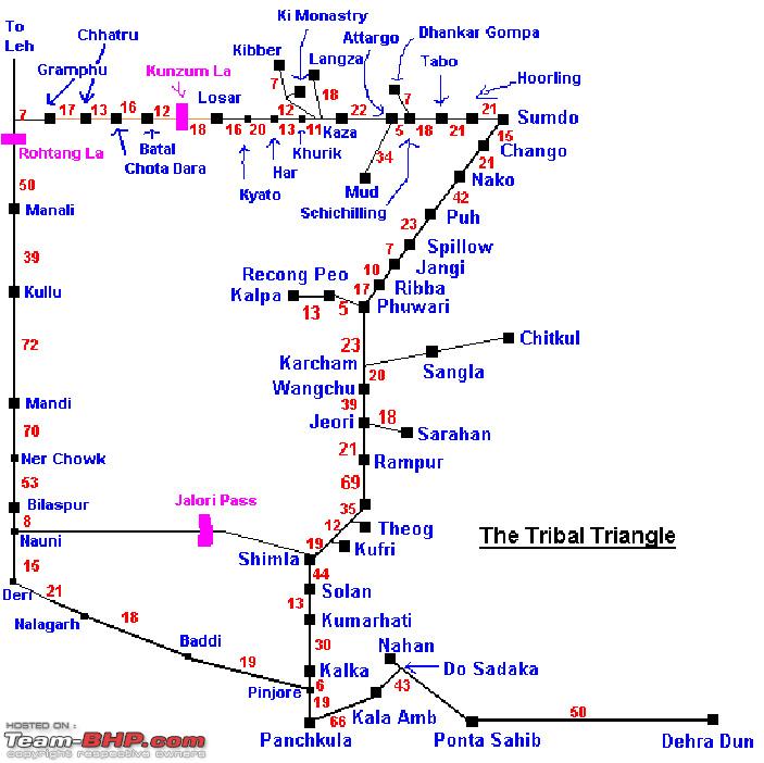  |
|
| (4)
Thanks
|
| The following 4 BHPians Thank dinesha for this useful post: | ajay0612, Klub Class, mercedised, parsh |
|
19th July 2011, 18:31
| #5 |
| Senior - BHPian | Dinesha, this is zone i am targetting for our next visit. I did till narkhanda in march. Your log would certainly help me plan it. I am hooked. |
|
| ()
Thanks
|
|
19th July 2011, 19:09
| #6 | ||
| BHPian Join Date: Aug 2009 Location: New Delhi
Posts: 320
Thanked: 177 Times
| Re: Travelogue: A family trip across Kinnaur and Spiti Nice start, dinesha. Looking forward to the full travelogue. Quote:
Quote:
| ||

| (1)
Thanks
|
| The following BHPian Thanks akp for this useful post: | hvkumar |
|
19th July 2011, 22:53
| #7 | ||||
| Senior - BHPian Join Date: Nov 2006 Location: Mumbai
Posts: 7,369
Thanked: 3,454 Times
| Re: Travelogue: A family trip across Kinnaur and Spiti Quote:
Quote:
Quote:
Quote:
Any idea if Ramesh Lal can help with camping out in Chandra tal? | ||||
|
| ()
Thanks
|
|
19th July 2011, 22:55
| #8 | |
| Senior - BHPian Join Date: Nov 2006 Location: Mumbai
Posts: 7,369
Thanked: 3,454 Times
| Re: Travelogue: A family trip across Kinnaur and Spiti Quote:
| |
|
| ()
Thanks
|
|
19th July 2011, 23:14
| #9 | |
| BHPian Join Date: Aug 2009 Location: New Delhi
Posts: 320
Thanked: 177 Times
| Re: Travelogue: A family trip across Kinnaur and Spiti Quote:
We didn't stop at Basantpur, so not sure about stay options - though it didn't look like there would be decent options there. But Naldehra is just 15 km before that, and there are a few options there including HPTDC Golf Glade. | |
|
| (1)
Thanks
|
| The following BHPian Thanks akp for this useful post: | hvkumar |
|
20th July 2011, 09:27
| #10 | |||||||
| BHPian Join Date: Jun 2011 Location: New Delhi
Posts: 207
Thanked: 419 Times
| Re: Travelogue: A family trip across Kinnaur and Spiti Quote:
Quote:
Quote:
Attargo-Gulling- 10Kms Gulling-Sagnam-12Kms Sagnam-Mudh-12 Kms Please check the Maps attached above. The road condition is fine. We travelled there on 10th June were there were lot of melting glaciers betwen Sagnam and Mud. Lotey(ramesh Lal) had advised me not to go beyond Sagnam because of slush but the scenery beyond Sagnam kept us calling.We decided to travel as far as the raod was driveable. We did not face any problem. For your caravans Scorpios and Boleros it will be a no game. I am glad that we made it upto Mudh. The place is very humbling. Next time I plan to stay there atleast one night. Quote:
In-fact I wanted to desperately go to the Chandrataal and camp there for a night with my Kids. But for that I would have had to trek the entire route from Kunzum/Batal. Lotey told me that if I intended to do it he would arrange everything including camping gear/porter/food and it would not cost much. I did not go there as it would have been difficult with Kids. In spiti he has become a friend for all his help and support. I will call him and let him know to expect a call from you. Quote:
Quote:
Quote:
I have traveled Basantpur-Sunni-Rampur stretch on return . This road is in bad shape between Sunni and Sainj. But I will not say it to be undriveable. No deep potholes or risk of damaging the vehicle. It will be little rough for an hour and it is quite managable I think. but If you are after scenic roads then i would suggest do either of this: a) Narkanda-Thanedar-Bithal-Rampur Same travel time as NH22. You will love the apple orchard in the full blossom. b)Narkanda-Baggi-Khadrala-Sungri-Taklech-Dharanghati-Mashnoo-Sarahan It is a dirt trek between Dharanghati and Mashnoo with no traffic but somebody did it last year in Innova could be easily done by your vehicles. This is the route I want to most defiantly take next time I travel there. The scenic beauty through this road is said to to unmatched and beats most places in Kinnaur and Spiti. All these roads are quite easy comparable to places you will be going beyond Leh. Regard Dinesh A. Last edited by dinesha : 20th July 2011 at 09:42. | |||||||
|
| (4)
Thanks
|
| The following 4 BHPians Thank dinesha for this useful post: | drk_411, hvkumar, laluks, v&v |
|
20th July 2011, 09:52
| #11 | |||
| Senior - BHPian Join Date: Nov 2006 Location: Mumbai
Posts: 7,369
Thanked: 3,454 Times
| Re: Travelogue: A family trip across Kinnaur and Spiti Quote:
Quote:
Quote:
| |||
|
| ()
Thanks
|
| |
|
20th July 2011, 10:09
| #12 | ||
| BHPian Join Date: Jun 2011 Location: New Delhi
Posts: 207
Thanked: 419 Times
| Re: Travelogue: A family trip across Kinnaur and Spiti Quote:
This is what you will see at Attergo bridge from Tabo side towads Kaza  From Kaza side.  Quote:
Regard Dinesh A | ||
|
| (1)
Thanks
|
| The following BHPian Thanks dinesha for this useful post: | hvkumar |
|
20th July 2011, 10:30
| #13 | ||
| BHPian Join Date: Aug 2009 Location: New Delhi
Posts: 320
Thanked: 177 Times
| Re: Travelogue: A family trip across Kinnaur and Spiti Quote:
Quote:
| ||
|
| (1)
Thanks
|
| The following BHPian Thanks akp for this useful post: | drk_411 |
|
20th July 2011, 12:30
| #14 | |
| Senior - BHPian Join Date: Nov 2006 Location: Mumbai
Posts: 7,369
Thanked: 3,454 Times
| Re: Travelogue: A family trip across Kinnaur and Spiti Quote:
| |
|
| ()
Thanks
|
|
20th July 2011, 13:51
| #15 |
| BHPian Join Date: Jun 2011 Location: New Delhi
Posts: 207
Thanked: 419 Times
| Re: Travelogue: A family trip across Kinnaur and Spiti ROAD DETAILS: ROUTE (ALTITUDE MSL) Distance SHIMLA – NARKANDA (64 km) Shimla – Wild Flower Hall (2498m)............13 km Wild Flower Hall – Kufri (2510m)...............03 km Kufri – Fagu (2500m).......................……..06 km Fagu – Narkanda (2708m)..............………..42 km NARKANDA – SARAHAN (112 km) Narkanda – Kumarsain (2150m)........………..16 km Kumarsain – Sainj (1372m)..............………..15 km Sainj – Nirath (945m).....................………..18 km Nirath – Dutt Nagar (970m)...........………... 06 km Dutt Nagar – Rampur (1005m).........………...09 km Rampur – Jeori (1250m)..................………..23 km Jeori – Sarahan (2165m).................………..17 km ALTERNATE ROUTE::Shimla-Basantpur Shimla-Mashobra Mashobra-Naldhera Naldhera-Basantpur ALTERNATE ROUTE::Basantpur-Sainj Basantpur-Sunni Sunni-Luhri...................................………..49 km Luhri-Sainj....................................………..06 km ALTERNATE ROUTE::Basantpur-Sainj Basantpur-Kinjal Kinjal-Sainj ALTERNATE ROUTE::Narkanda-Sarahan Narkanda-Tanedhar Tanedhar -Bithal Bithal-Rampur Rampur-Sarahan ALTERNATE ROUTE::Narkanda-Sarahan Narkanda-Baggi Baggi-Khadrala Khadrala-Sungri Sungri-Taklech Taklech-Dharanghati Dharanghati-Mashnoo Mashnoo-Sarahan SARAHAN – KARCHHAM(77 km) Sarahan – Jeori (1250m) ................………..18 km Jeori – Chora (1260m)................………..…..11 km Chora – Bhawa Nagar (1450m)..................20 km Bhawa Nagar – Wangtu (1830m)................09 km Wangtu – Tapri (1683m)................………...10 km Tapri – Karchham (1899m)................……….09 km KARCHHAM -SANGLA – CHITKUL(44 km) Karchham – Sangla (2680m)................……18 km Sangla – Chitkul (3480m)................………..26 km KARCHHAM – KALPA(33 km) Karchham – Powari (2170m)............………..13 km Powari – Recong Peo (2290m)....................7 km Recong Peo – Kalpa (2900m)..................…13 km KALPA – TABO (170 km) Kalpa – Akpa (2238)................………........37 km Akpa – Morang (2276m)................………….. 8 km Morang – Spello (2244m)................…...…..24 km Spello – Puh (2837m)................………...…..11 km Puh – Khab (2831m)................……….....…..10 km Khab – Nako (3800m)................……….......21 km Nako – Chango (3658m).................…….....20 km Chango – Shikhar (3119m).................…….. 6 km Shikhar – Sumdo (3230m)................……….. 7 km Sumdo – Tabo (3050m)................…………..32 km TABO – ATTARGO (24 km) Tabo – Poh (3150m)................………………..10 km Poh – Sichiling (3190m)................…………..11 km Sichiling – Attargo (3250m)................…….. 3 km ATTARGO-LALUNG (LINGTI VALLEY) (14 km) (Forks outs Near Attargo) ATTARGO-DANKAR (7 km) (Forks outs Near Attargo) ATTARGO-MUDH (PIN VALLEY) (34 km) Attargo-Gulling ................………......………..10 km Gulling-Sagnam................……….......………..12 km Sagnam-Mudh................………...........……..12 km ATTARGO-KAZA 23 km Attargo – Lara (3360m)................…………….13 km Lara – Kaza (3600m)................………......….10 km KAZA-KI-KIBBER-TASHIGANG (36 km) Kaza – Ki – Monestery (4116m)...........……. 12 km Ki – Monestery – Kibber (4205m)............…….8 km Kibber – TASHIGANG (4503m)...............…….14 km KAZA-LANGZA-KOMIC (26 km) Kaza – Langza (4250m) Langza-Komic (4530m) [**HIGHEST MOTORABLE VILLAGE IN THE WORLD**] KAZA – KELONG (187 km) Kaza – Rangrik (3700m)................………...... 8 km Rangrik – Khurik (3750m)................…..…….. 4 km Khurik – Sumling (3790m)..................…….... 4 km Sumling – Murang (3800m)................……….. 4 km Murang – Hula (3845m)................…………….. 5 km Hula – Pangmo (3896m)................……..…….. 4 km Pangmo – Kiato (3964m)................…………..13 km Kiato – Hanse (3950m)................…….……….. 3 km Hanse – Losar (4079m)................…..………..12 km Losar – Kunzam Pass (4551m)...........………..19 km (Chandertal lake Trek 11kms from here) Kunzam Pass – Batal (3560m)…...........……….12 km(Chandratal Parking 3 Kms+ 3 Kms Trek from here) Batal – Chhota Drara (3690m)...........….……..15 km Chhota Drara – Bara Drara (3690m).....……….. 8 km Bara Drara – Chhatru (3560m)...........….…….. 9 km Chhatru – Gramphoo (3200m)............………..17 km Gramphoo – Khoksar (3140m).............……….. 5 km Khoksar – Sissu (3160m)...........……….………..15 km Sissu – Gondla (3160m)....................………..13 km Gondla – Tandi (2573m)...........……….....…….. 9 km Tandi – Keylong (3350m)...................……….. 8 km KELONG-MANALI (187) Kms Kelong – Tandi (2573m)...........………..……….. 8 km Tandi – Kirting (3350m)...........………...……….11 km Kirting – Shansha (3721m)...........…….……….. 2 km Sahnsha – Jahlma (3111m)...........…………….. 6 km Jahlma – Thirot (3005m)...........………...……..10 km Thirot – Arat (2870m)...........………....……….. 7 km Arat – Trilokipur (2760m)...........……………….. 4 km Trilokipur – Udaypur (2650m)...........….……..11 km Udaypur – Tandi (2573m)...........……..………..43 km Tandi – Khoksar (3140m)...........……….………..37 km Khoksar – Rohtang Pass (3980m)........………..20 km Rohtang Pass – Marrhi (3354m)............……..15 km Marrhi – Kothi (2530m)...........………....………..24 km Kothi – Manali (2050m)...........………....………..12 km [Gosh this post was real pain. It took a while for me to put those dots. I hope it is useful to others.] Excuse If typographical errors. Regards Dinesh A. Last edited by dinesha : 20th July 2011 at 14:10. |
|
| (17)
Thanks
|
| The following 17 BHPians Thank dinesha for this useful post: | .anshuman, A.G.The Rambler, ajay0612, akp, Biraj, canonguy, codelust, drk_411, hvkumar, jsrakkar, laluks, parsh, raju2512, rk_sans, sj911, Turbanator, Ym-enjn |
|