Team-BHP
(
https://www.team-bhp.com/forum/)
-
Travelogues
(
https://www.team-bhp.com/forum/travelogues/)
After returning to the highway, we got some excellent roads all the way up till Baralacha La. There were no reflections in Deepak Tal due to the wind, and for the first time we saw tents around it. At Patseo, we saw, as usual, a fleet of Stallions parked. We were anticipating a decent water crossing (read a difficult one) at Zing Zing Bar, as some T-logs had warned, but didnt come across any, probably because it was still very early in the day. The climb to Baralacha La has some good shortcuts which looked quite steep and difficult, sufficient enough to make Kiyang sweat. But we resisted our urge in order not to lose any more time than we already did. The sight of the unfrozen Suraj Tal was mesmerizing, the blue, brown and white landscape giving the place a painting like effect. As we got down to shoot the lake, a huge Lammergeier swooped on a rocky ledge above us, and then immediately disappeared out of view. We hardly had any time to respond with our cameras but the huge white wing-span of the bird was so enticing that I was determined to get a shot, and almost began climbing the scree slope. However, given our time constraint, and the low probability of the spotting the bird again, I resisted the urge to undertake the mini quest. A shot of the bird would have been a prized possession though. We soon reached Baralacha La top which was windy as always, and we only stopped there very briefly.

Even Deepak Tal boasts of dhabas now!

The army camp at Patseo is huge, and one drives through it

A view down below, while ascending Baralacha La

These series of hairpin bends could have been avoided by that scree short-cut

Looking at an un-frozen Suraj Tal for the first time

The Suraj Tal adds the perfect touch of blue to the otherwise brown and white landscape

A trek which is very much on the cards in the future - towards Chandratal from Baralacha La

Finally at Baralacha La top
Then began the descent to the Sarchu plains. As we climbed down, we crossed the spot where we had been stranded for 8 hours (across two days) last year, and clicked some pictures for comparison with those from the year before. We then came across a set of tent dhabas, and at first could not understand what the place was. Soon it dawned on us that this was Bharatpur City, and then realized the meaning of what a friend, KD, had once said - that you dont always get to see Bharatpur City. It comes on and goes off overnight! We gave a lift to some people from there, and on our way to Sarchu discussed the dates when they had put up their dhabas last year, and how wed missed them by just one day.

The elusive Bharatpur 'City'

The bridge where we were stuck last year, devoid of snow now

The mountains around that bridge too were completely devoid of snow, whereas last year they were all white

This one helped a lot in clearing the road last year

A rough patch of road after Killing Sarai
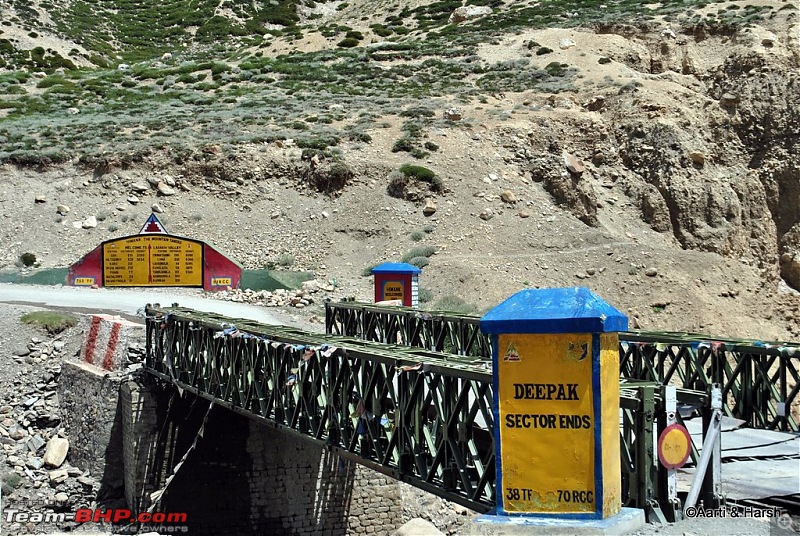
The sight of the Sarchu plains is heart-stopping! No matter how many times one does the Manali-Leh highway, this sight will never ceases to awe. Plains and straight roads at that altitude are nothing but spectacular! Immediately before Sarchu tents, one crosses a bridge which forms the border between Himachal and J&K. It also marks the end of Project Deepak and Project Himank begins. For the uninitiated, these are two separate projects run by the BRO to maintain these roads.

The incredibly straight and tarred roads

Colors of nature - green, purple and brown, all on the same mountain

The other bank of Tsarap Chu looks very enticing as well! Wonder how one goes there... hmmm.
The bridge which marks the natural border between Himachal & Ladakh

Lunch break at Sarchu
We broke for a quick lunch at the Sarchu tents, and chatted with a brave Spanish couple on a rented bullet from Delhi. With little knowledge of English (and of course none of Hindi) and age not on their side, they had decided to do this highway all by themselves. I would say it was nothing but courageous. After exchanging pleasantries, we moved on.
Beautiful detailing of the routes and the photographs with fine-grained details.
Thanks for the Google Earth reference - that helped clear the geographical location of the places/villages/passes.
Wish I could rate this thread again.
Awesome. As always, you keep the audience glued to your thread. Keep them coming. I could not stop myself from reading after seeing a new post from you. Great going bro - Keep it Up.
Fantastic pics and informative log. Thanks for sharing.
Beautiful....What Camera you are using?
Quote:
Originally Posted by aryasanyal
(Post 2474324)
Beautiful detailing of the routes and the photographs with fine-grained details.
Thanks for the Google Earth reference - that helped clear the geographical location of the places/villages/passes.
Wish I could rate this thread again.
|
Thanks buddy. Although Google earth reference was entirely Sudev sir's idea. I was just the implementer.
Quote:
Originally Posted by Funda
(Post 2474921)
Awesome. As always, you keep the audience glued to your thread. Keep them coming. I could not stop myself from reading after seeing a new post from you. Great going bro - Keep it Up.
|
Quote:
Originally Posted by ajay0612
(Post 2475198)
Fantastic pics and informative log. Thanks for sharing.
|
Quote:
Originally Posted by agspins
(Post 2475271)
Beautiful....What Camera you are using?
|
Thanks guys, Camera = Nikon D3000 + D3100, Lens = 18-55mm stock + 55 - 300mm. Filter = UV + CPL.
The Sarchu plains extend for quite a while even after the tents. One follows the Tsarap Chu and crosses over a bridge over one of its many tributaries till the ascend of the Gata Loops begin. A little known fact about Tsarap Chu is that it originates somewhere in the Spiti region a little North of Losar, with tributaries also coming in from Baralacha La (Yunam river) & Phirtse La (Lingti Chu, near Kargyak village in Zanskar).
The Yunam river and Lingti Chu join somewhere when we descend the Baralacha La, to eventually join Tsarap Chu after the Sarchu tents. From here we leave the river at Gata Loops to continue our journey towards Leh. The river itself twists and turns, including twin U-bends, crosses the Phutgal Gompa and eventually joins the Kargyak Chu to form what we know as Tsarap Lingti Chu. This eventually drains into Doda (Stod) river a little after Padum to form the mighty Zanskar. Phew! So theoretically, if one gets into a raft at Sarchu, they could go all the way into Pakistan and drain out into the Arabian Sea near Karachi!

The plains extend for a while after the Sarchu tents.

Loved the name: Twing Twing bridge.

The Gata Loops begin

We leave the lovely Tsarap Chu to continue with its long journey.
As compared to this long journey of Tsarap Chu, we continued our smaller journey towards Leh by climbing the Gata Loops. I unfortunately could not take any shortcuts on those bends, thanks to Aartis wish to COUNT all the 21 loops! So 21 hairpin bends and lot of frustration later, we reached Nakee La. A short descent from the pass, and then one starts the gentle climb to reach the next pass, Lachulung La. Thankfully, this time around I convinced Aarti not to stay on the road, and allow me to take a shortcut, basically do an off-the-road climb. Needless to say, it was good fun. After spending a while at the pass and chit-chatting about the climb to Marsimek La with an NIOC guy who was in a Gurkha with his wife, we moved on. While descending from Lachulung La, we spotted some Bharals at the very same spot where wed seen them last year. This gang of Bharals also had some kids in it, and they were curious enough about us to pose for some nice shots.

Nakee La

The short-cut that we took is towards the left.

Parked at Lachulung La

The route ahead of Lachulung La as seen from the pass.

Cute Bharals

And their even cuter kids!
The most dramatic stretch of the Manali - Leh highway starts after Lachulung La. The road mostly runs along the river Lachulung Lungpa, at times almost level with it, and the mountains on either side seem as barren and as majestic as ever. One truly feels dwarfed by the magnitude of the landscape around. The notorious Kangla Jal is not much of a nuisance anymore, with the road having been cemented and also made broader at that point. We then climbed a bit, crossed a mountain, and then descended again to cross a pretty looking bridge. The valley opens up a bit after this, and one can spot the famous landmark, the wind-carved archway, which warrants a photography break. Hoodoos, the weird structures formed as a result of continuous wind erosion, come up next, and all one can do is sigh and revel in the beauty of the vista around. And this is when one knows that the stupendous Moreh Plains are up next!

A lovely temple enroute Kangla Jal

We follow the Lachulung Lungpa all the way till Pang.

Kangla Jal is not a challenge anymore! :(

A quaint bridge over Lachulung Lungpa

The famous archway before Pang

The Hoodoos, caused by years of wind erosion

Finally we reach the Pang military base
As we ascended to Pang, we could hardly control our excitement to see the Moreh Plains. However, when Aarti saw a souvenir shop at Pang, all excitement was postponed, and off she went to shop. Thinking that this would take care of most of her shopping for the trip, I too went in to help. This clever thinking helped me save at least half a day of shopping at Leh. God bless the army for bigger things and even smaller pleasures such as these. The shop had closed for the day, but the army men in charge showed us the stuff. After buying all kinds of souvenirs ranging from beer mugs to table clocks, we finally got back into the car and drove on.
There are very few sights that can overwhelm you as much as the vast Moreh Plains unfolding before your eyes after Pang. It is as if you suddenly come upon a flat table top, and can simply not see the end of the table! Just as one enters the Moreh Plains, the view from the edge of the plateau of the Sumakhel Lungpa river winding through the valley beyond is simply beyond words.
We decided to not drive on the road on the Moreh Plains, and for quite a while drove parallel to the actual road. However, once the stretch we were driving on turned marshy, we had to quickly join the road, which right now is still under construction, with diversions every 200 meters.

At Pang La, overlooking the Sumakhel river. It's a sight to behold!

The table-top at 4750m above sea level!

We could be crusing at 100 kmph once the straight, flat road on Moreh Plains is constructed!

A panorama of the vast Moreh Plains

Kiyang at Moreh Plains

The day about to end, and we are still some distance away from our destination for the day.
It was 7:15 pm by now, and we had just taken the decision to camp at Debring, about 15 kms away, when we came across a sign board about a camp just 3 kms from the road in Panginagu, next to Tso Kar. We were tired and in no mood to pitch our own tent (it is not the easiest tent to pitch), and quickly decided in favour of going to Panginagu. The thought of spending the night next to the beautiful Tso Kar was also quite tempting. Although the board mentioned it to be 3 kms away, even after 5 kms, we could not see any sign of the camp. A feeling that was quite similar to the one we experienced last year at Tso Moriri dawned upon us. A feeling of going down the wrong path at dusk, with no option left but to pitch our own tent in the middle of nowhere. We were really not up for that today. Thankfully, we found the camp site after about 20 minutes, and were glad to see that they had nice and clean tents. Having our own tents did help us bargain immensely on the rates. It was slashed from 3000 bucks (including dinner & breakfast) to a reasonable 1200.
After a nice dinner of noodles and baked beans, we retired for the night. It was cold, and we were also feeling a bit breathless. However, tiredness took over, and instead of popping a Diamox, which would have been the prudent thing to do, we just went off to sleep. At least Aarti did manage to sleep, while I simply tossed and turned. For the first time AMS hit me, and it was a long, restless night resulting in a complete change of plans for the next day...
Next >>
Another beautiful Leh travelogue. Seems like its the most visited place on team bhp :). But for some reason each travelogue seems to me as fresh as the 1st one from TSK that i read a while back. Great going. Waiting for further updates.
Hai Harsh,
There you go again!! My left ventricles did a tango all by itself when I saw the Zanskar photos, we could not complete that trip and had to terminate at Rangdum. The photos and your narration brings a warm rush.
Great to see those photos and story, waiting for more. Please go on....
--Ramky
======
Lovely work. rated 5 stars. However, I still think if you'd have left Manali at midnight or max 1am, life wouldve been FAR simpler with zero taxis around. no?
Quote:
Originally Posted by vardhan.harsh
(Post 2475726)
However, tiredness took over, and instead of popping a Diamox, which would have been the prudent thing to do, we just went off to sleep. At least Aarti did manage to sleep, while I simply tossed and turned. For the first time AMS hit me, and it was a long, restless night resulting in a complete change of plans for the next day...
|
I think taking a Diamox after AMS hits you has limited effect. If i am not wrong Diamox has to be taken atleast a day in advance before starting the ascent from Manali. Am i correct??
Quote:
Originally Posted by phamilyman
(Post 2476352)
Lovely work. rated 5 stars. However, I still think if you'd have left Manali at midnight or max 1am, life wouldve been FAR simpler with zero taxis around. no?
|
the problem is usually the previous days jam nowadays.
Quote:
Originally Posted by supertinu
(Post 2476198)
Another beautiful Leh travelogue. Seems like its the most visited place on team bhp :). But for some reason each travelogue seems to me as fresh as the 1st one from TSK that i read a while back. Great going. Waiting for further updates.
|
The place deserves to be the most visited place in India. The barrenness one finds there is unparalleled. Each journey to this unique is different as well, with the uncertainties of the road giving a taste of different adventures to people.
Quote:
Originally Posted by ramkya1
(Post 2476336)
Hai Harsh,
There you go again!! My left ventricles did a tango all by itself when I saw the Zanskar photos, we could not complete that trip and had to terminate at Rangdum. The photos and your narration brings a warm rush.
Great to see those photos and story, waiting for more. Please go on....
--Ramky
======
|
In my opinion, Rangdum and the Drang Drung glacier are the two highlights of this route which rate far better than any other in Zanskar. You've already experienced one of the major highlights, the other one surely will not wait for long. Will update the post soon.
Quote:
Originally Posted by phamilyman
(Post 2476352)
Lovely work. rated 5 stars. However, I still think if you'd have left Manali at midnight or max 1am, life wouldve been FAR simpler with zero taxis around. no?
|
Quote:
Originally Posted by tsk1979
(Post 2476381)
the problem is usually the previous days jam nowadays.
|
Thanks buddy, As Tanveer rightly said, the taxi pile up was spill-over of the previous days. Wouldn't have helped much in this case.
Quote:
Originally Posted by amitwlele
(Post 2476379)
I think taking a Diamox after AMS hits you has limited effect. If i am not wrong Diamox has to be taken atleast a day in advance before starting the ascent from Manali. Am i correct??
|
True, It's best to take Diamox as a preventive medicine rather. Once AMS sets in, it hardly helps much.
Quote:
Originally Posted by amitwlele
(Post 2476379)
I think taking a Diamox after AMS hits you has limited effect. If i am not wrong Diamox has to be taken atleast a day in advance before starting the ascent from Manali. Am i correct??
|
Before and after the Ladakh trip did extensive research on AMS / Medication. I was hit by it at Zojila (bad bout there and could not drive, practically passed out after vomiting) and at Rangdam (was bad but better as I was acclimatizing slowly) while my two friends Prajesh and Jignesh were hit mildly and came out of it fast. I chose NOT to take Diamox due to many reasons. IMHO the best plan would be NOT to take medicines, sleep at gradual heights, rest and hydrate enough & try to cope. Very few people actually have to scuttle the trip due to AMS.
I've created a comprehensive FAQ here after the trip for AMS, may be helpful:
http://www.team-bhp.com/forum/travel...ml#post2005779
--Ramky
======
A note before you proceed reading:
Kiang = A wild as$, whose home is the cold desert of Changthang.
Kiyang = A wild Tata Safari, whose home is New Delhi, at times found in the cold desert of Changthang.
The night before had been terrible. I could not sleep at all, was feeling cold throughout, and to top it all I also had an upset stomach. Wed planned to leave at 5:30 in the morning to explore the Tso Kar basin and come back to the camp for breakfast. Then we had planned to go to Yar La and Datgo (the Rupshu region) before lunch, before finally heading off towards Leh. Although we did wake up at 5:00 am, I was in no position to go, having not slept a wink the previous night. We went back to sleep, and only woke up at 8:30. Sadly, it was now too late to do both the Tso Kar basin and Yar La, so we decided to explore the former. Both our heads were throbbing badly, and we wanted to take it a bit easy. After a lazy breakfast, we finally moved from the camp at 10 am.
The people at the camp had told us that the dirt track that led us there would go till the lake, but beyond that they had little idea till where it went. So far our tryst with the lake was from a distance, and naturally we were eager to get a closer look. As we moved ahead on the track, the pretty lake slowly came into view. We realized how big Tso Kar really was, and what a small bit of it wed seen last year. Thankfully, there was hardly any wind at the time, and the lake was perfectly reflecting the mountains behind it. The lovely blue sky dotted with fluffy white clouds completed the perfect picture. We spent some time soaking in the vistas, before moving on.

A Google Earth snapshot of the Tso Kar Basin

Kiyang enjoying its natural habitat.

Surprisingly perfect reflections at Tso Kar, least expected.

A panorama of the vistas around us.

The left most part of the above panorama gives one an idea of the scale of things!
The Tso Kar basin is beautiful, and a large part of it was covered with purple shrubs this time of the year. These shrubs also grow on mountains, giving the whole landscape a purplish tinge. The fact that the place is a wetland only adds to its beauty.
Soon we came to the tiny village of Riyul, from where the track bifurcated, one leading towards the lake and to the village of Nuruchan, and the other towards the end of the basin and to the village of Chutak. We opted for the latter, since we also wanted to glimpse the Startspuk Tso, having missed it last year. My hidden agenda was to check if the dirt-track went all the way till Kiagar Tso, had a hunch that it just might. For a change, the hunch was wrong and we did manage to hit a dead-end at the village Chutak.
The outline of a village, which we now know as Chutak, appeared in the distance, and that is where the track was going. We hesitated a bit, since we wanted to circle the lake, but then curiosity tempted us to check out the village. All this while, we were hoping to spot a Kiang, as we had seen them last year in this very wetland, on the opposite side of the lake. Just as we were losing hope, we spotted two of them, and one crossed the track right in front of us. We were elated, and spent some time trying to capture the Kiang on camera, but did not get good shots as it soon ran away.
As we neared the village, we saw that its boundaries were fenced. Inside the village, however, all we could see were locked houses, and not a soul around. We went up till the end of the village, which was also the end of the basin. The end was uncharacteristic, the terrain ahead was simple enough to have dirt-tracks and the climb ahead to Startspuk La seemed easy for a 4WD! However, there were no dirt-tracks. Not even signs of tyre tracks which we could follow. My hunch was thus rendered false, and we realized that the route from there to Kiagar Tso was only a trekkable one for now. We could still not see any person or animal around. Some houses had what seemed like pashmina goat wool on top of their roofs, but ALL of them were locked. We could not figure out if the village was abandoned or if the villagers had simply gone out to earn a living, which of course would mean grazing their flock!

The tiny hamlet of Riyul

The track ends here, the trek route and Startspuk La can be seen ahead.

The ghost village of Chutak

The villagers must have gone out to work. There was precious Pashmina wool (Pashm) kept on the top of this house.

Purple shrubs, a fenced road, a vast landscape!
We then retraced our steps and went all the back till Riyul where the track had bifurcated. We now took the other path which led towards the lake and to Nuruchan. This path was much less used, and we sometimes even lost the tyre tracks for a few meters. It was also much closer to the lake, and hence we had to be careful not to veer off into any marshy areas or worse onto any part of the wetland. In the distance, we saw a watch tower, and concluded that this must be used by bird watchers to monitor the movement of migratory birds.
Along the way, we spotted two or three brown spots far away, and on looking through the zoom lens figured that they were actually Kiangs. I even got down from the car to capture two of them on camera. As I was walking back, they too seemed to follow me. Then, they stopped pretty close to us, and stared. And stared. And stared. Took a graceful turn, in perfect coordination, and then stared. And stared. And stared. Took a graceful turn, in perfect coordination, and then stared. And stared... and so on! All this while, Aarti had been shooting furiously with the zoom lens, and even managed to shoot a video of their antics. We were bewildered by these two brave and bold Kiangs, so curious about us humans that they did not let us out of their sight even for a second. It was us who had to finally give up and drive away when we got the feeling that this cycle might actually go on the whole day! But indeed, the grace with which the Kiangs carry themselves is marvelous. Everything about them - their slender, athletic body, their beige and brown colour which completely blends into the barren surroundings, their cute, alert ears, their majestic mane, the way they run with their heads up - is beautiful. What elegant creatures! Needless to mention, we were absolutely thrilled with the attention we got from them. :)

A bird watch-tower, must be used by Ornithologists

I went after them Kiangs, on foot this time.

300mm at its best!

Assess of wild asses!

The story of a monster with 5 legs and two heads.

The perfect pose!

Kiang love!

The closet I could get to them, pretty close I reckon
Syncronized ballet of Kiangs - YouTube
A video of their synchronized ballet!
We also spotted the tiny Startspuk Tso in the distance. Both of us somehow love the name of that lake, and were glad to have finally seen it. Realizing that this track too did not cut across the lake, as marked on the map we had, we went back the way we had come. Some Brahmini ducks were frolicking on the edge of Tso Kar, but we couldnt get good shots of them as they were very shy and flew away at the slightest indication of movement. We had almost reached our camp at Panginagu when we noticed some marmots on either side of the track, and were delighted at having spotted the one animal that we were really missing.

A painted stone on a Mani wall

A Himalayan Marmot, there were many in the Tso Kar basin, although very shy

Brahmini ducks

Our camp site for the night at Panginagu
| All times are GMT +5.5. The time now is 20:35. | |


