Team-BHP
(
https://www.team-bhp.com/forum/)
-
Travelogues
(
https://www.team-bhp.com/forum/travelogues/)
Quote:
Originally Posted by Sutripta
(Post 2795101)
So essentially 2.5 hrs to cross ~80 Km of Jharkhand?
And 2H20M to cross Bihar? Distance?
Calcutta - Kishanganj -> 10.5 Hrs?
31 Km from Kishanganj: Mahananda Bridge?
|
Dear Sutriptada,
Possibly it took me around three hours, may be slightly more, to cover Jharkhand, because the JH state boundary starts before reaching Massanjore. While I am aware from the EXIF data of the picture that I entered Bihar at around quarter past ten, I am not sure when did I leave. But considering that I left home at around 03-15 in the morning, it must have taken me about twelve hours to reach Kishanganj. And just now I have noticed that I still retain a hotel receipt issued by Mainak tourist lodge at Siliguri, mentioning that I was given a room by them at 04-45 PM.
Warm regards,
Rahul
Quote:
Originally Posted by 1100D
(Post 2795135)
I can forward you the detailed trip log if you need. Roads in Bihar were better, and if you find out the way to avoid the Bhagalpur railway station, you will be out of Bhagalpur in 25 minutes even at peak hours.
|
A trip log will be extremely beneficial. I have been eyeing this route for some time now after feeling discouraged about NH34. Looks like only the route before Dumka from Massanjore dam is broken and a sedan needs to be cautious (your raised Scorpio would zip it in contrast ;)). From the pictures it looks like the route after Dumka is average but driveable if one is careful of the potholes and speed breakers. I am assuming this stretch is better than the car breaker stretches between Baharagora and Jamshedpur. Looks like an ideal alternate option of reaching Siliguri in about the same time or even less :thumbs up.
Quote:
Originally Posted by samarjitdhar
(Post 2795744)
Looks like only the route before Dumka from Massanjore dam is broken and a sedan needs to be cautious (your raised Scorpio would zip it in contrast ;)). .
|
Its not even from Messanjore. Infact the Siuri (Seorakuri more) - Messanjore road extends for another 15 km, absolutely fabulous surface meandering through small hillocks and lush green. 15 Kms from Messanjore this road ends in a T junction at Pattabari, you take a left there and immediately hit the brakes for another 15 kms to Dumka. It is this 15kms that has to be done carefully. However not even quarter as bad as Baharagora. The trick will be to utilise the entire width of the road you will find a clean path most of the time. At certain places, there is an elevated earthen road beside, this can also come in handy. This 15 kms will take around 40 minutes. I will do it faster in my Ikon than in my Scorpio, the dynamic ability helps.
Quote:
Originally Posted by samarjitdhar
(Post 2795744)
From the pictures it looks like the route after Dumka is average but driveable if one is careful of the potholes and speed breakers. I am assuming this stretch is better than the car breaker stretches between Baharagora and Jamshedpur. Looks like an ideal alternate option of reaching Siliguri in about the same time or even less :thumbs up.
|
After Dumka, its only upto about Hansdiha that the road has intermittent potholes, but the scenery is quite good. Hansdiha is about 41 kms from Dumka clock tower. 6 kms from Dumka clock tower is Maharo fork (picture that Rahul4640-da has attached), one keeps right on that and drives for another 35kms to reach Hansdiha. The surface from there, save a few culverts whose ramps are still being made, the surface is smooth to sail at a decent speed. Very little traffic, very little opportunities of delay, apart from a few very small towns like Banka road that comes up.
Also attaching the trip log excel, that my father created. One difference that I noted was that, contrary to what I said yesterday, we actually went through Panagarh to Illumbazar due to certain availability of brakfast at the Kaksa/Darjeeling more
Howrah To Siliguri-2012.xls
Quote:
Originally Posted by 1100D
(Post 2795786)
... It is this 15kms that has to be done carefully. However not even quarter as bad as Baharagora. The trick will be to utilise the entire width of the road you will find a clean path most of the time. At certain places, there is an elevated earthen road beside, this can also come in handy.
|
Awesomest. After doing Baharagora once a couple of years back and a carbon copy between Jamshedpur and Chandil this January, this sounds like not much of a challenge, though honestly I am not looking for one either. Yeaa for the fantastic TBHP members :Cheering:, any unknown road becomes a known one in minutes. I cannot get leaves now though the mere description of this road makes me want to drive it ASAP. Planning a trip to Bhutan so this will be very useful.
Quote:
Originally Posted by 1100D
(Post 2795786)
6 kms from Dumka clock tower is Maharo fork (picture that Rahul4640-da has attached), one keeps right on that and drives for another 35kms to reach Hansdiha.
|
Now you have almost written half of Rahul da's travelogue :D.
Quote:
Originally Posted by 1100D
(Post 2795786)
Also attaching the trip log excel, that my father created.
|
So, thanks again.
Quote:
Originally Posted by samarjitdhar
(Post 2795810)
Awesomest. After doing Baharagora once a couple of years back and a carbon copy between Jamshedpur and Chandil this January, this sounds like not much of a challenge, though honestly I am not looking for one either. .
|
Had been familiar with Lodhasuli-Baharagora-Jamsola uptil a few years back. Have done it on my Ikon couple of times as well as the Fiat. It has always been the same, and we do not expect it to change. But knowing that, this route is nothing.
We can have a team bhp meet-drive. Especially since, now the stretch between Seorakuri and Pattabari (via Messanjore) is a pure delight (infact was planning to take my Ikon there while driving back this time in Marengo). Add another 2 hours each side and you will know what you have to face. Nearing Dumka there is a Sristi park (at Kuruwa) it overlooks fantastic scenery and an airfield.
Quote:
Originally Posted by 1100D
(Post 2795135)
I can forward you the detailed trip log if you need.
|
That would be great. Deserves a separate thread, with a proper heading so that it comes up in searches.
You and Rahul can contribute while it is fresh in your minds.
Now to get someone to do (and write about) KGP - Bankura.
Regards
Sutripta
PS: I see you already have
Quote:
Originally Posted by 1100D
(Post 2795786)
|
Thanks. No GPS tracks? Your father would love it!
Quote:
Originally Posted by Sutripta
(Post 2796050)
Thanks. No GPS tracks? Your father would love it!
|
Unfortunately I dont have a navigator. Though he is quite fascinated by what the device can do, but since I have used some extensively in US, know that its a long way to go for it in India. He conspired and got me a Nokia Navigator phone, however that went into water at Mandarmani. The Garmin folks almost sold one to him at the time I was getting delivery of Marengo. Played a simple trick on the salesman. "Ask your device to take me home (at Howrah)" and the route it showed, I would never take even if I am not in my senses, even the second alternate was no good. However, I do see him going through googlemaps most of the time in his spare time, and these days, he just keeps on taking logs, plotting graphs, which does nothing to his predictive analysis.
Quote:
Originally Posted by 1100D
(Post 2795827)
We can have a team bhp meet-drive. Especially since, now the stretch between Seorakuri and Pattabari (via Messanjore) is a pure delight (infact was planning to take my Ikon there while driving back this time in Marengo). Add another 2 hours each side and you will know what you have to face. Nearing Dumka there is a Sristi park (at Kuruwa) it overlooks fantastic scenery and an airfield.
|
This poor thread has been totally hijacked by all us miscellaneous folks discussing all miscellaneous stuff now :uncontrol. Yes to a TBHP meet but let the rains set in. It will add to the experience most importantly the comfort level. From my estimates of the delayed monsoons, sometime in July should be good.
Quote:
Originally Posted by 1100D
(Post 2796121)
Though he is quite fascinated by what the device can do, but since I have used some extensively in US, know that its a long way to go for it in India.
....
However, I do see him going through googlemaps most of the time in his spare time, and these days, he just keeps on taking logs, plotting graphs, which does nothing to his predictive analysis.
|
Would love to meet him!
Quote:
Originally Posted by samarjitdhar
(Post 2796261)
This poor thread has been totally hijacked by all us miscellaneous folks
|
Poor? It has been enriched by the hijackers!
Seriously, some posts should be moved to say 'Calcutta to Siliguri without using NH34' or something similar.
Regards
Sutripta
Quote:
Originally Posted by samarjitdhar
(Post 2796261)
This poor thread has been totally hijacked by all us miscellaneous folks discussing all miscellaneous stuff now :uncontrol.
|
Quote:
Originally Posted by Sutripta
(Post 2796752)
Poor? It has been enriched by the hijackers!
|
Lol.. I dont have any problem about this thread being hijacked, but if Rahul Da does not create a separate thread he is going to face consequences. I am going to call him up in the middle of the night to get road directions :D.
Quote:
Originally Posted by Sutripta
(Post 2796752)
Would love to meet him!
Poor? It has been enriched by the hijackers!
Seriously, some posts should be moved to say 'Calcutta to Siliguri without using NH34' or something similar.
Regards
Sutripta
|
Quote:
Originally Posted by samarjitdhar
(Post 2796261)
This poor thread has been totally hijacked by all us miscellaneous folks discussing all miscellaneous stuff now :uncontrol. Yes to a TBHP meet but let the rains set in. It will add to the experience most importantly the comfort level. From my estimates of the delayed monsoons, sometime in July should be good.
|
Quote:
Originally Posted by BlackPearl
(Post 2796840)
Lol.. I dont have any problem about this thread being hijacked, but if Rahul Da does not create a separate thread he is going to face consequences. I am going to call him up in the middle of the night to get road directions :D.
|
Here we go - lets take the alternate route discussions to this one.
http://www.team-bhp.com/forum/route-...ml#post2796885
After the last end April fantastic travel with Blackpearl in his 4wd White Tusker, a travel was done again to Sandakphu and Phalut, Darjeeling district, West Bengal.
Back yesterday whereby we travelled by our Safari VTT to Maneybhanjang, left it over there for 3 days, and took the Landrover to travel to Sandakphu and Phalut. We were accompanied by another friend, his wife and their 5-yr-old daughter.
Also, a coincidence, as we were entering Siliguri for the journey towards Maneybhanjang, Blackpearl was headed towards Kolkata from Kaluk, Sikkim!
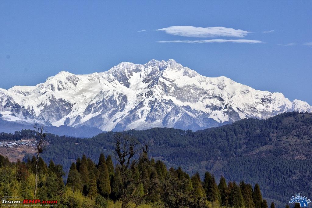
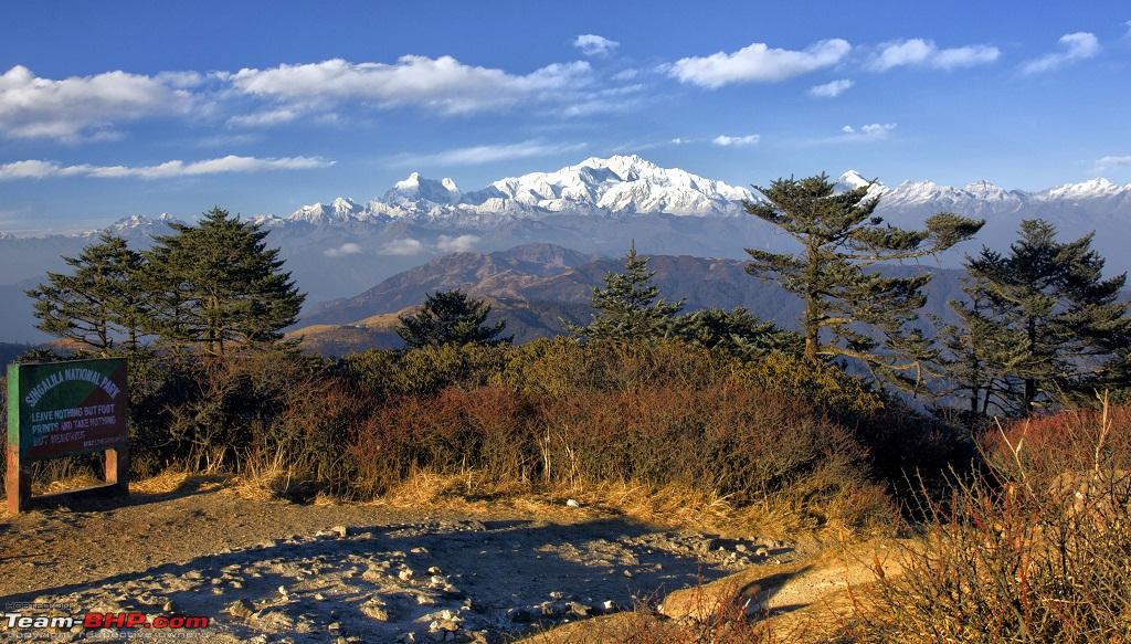
Sandakphu is the highest point in West Bengal with brilliant view of Kanchendzonga. Temperatures were below zero, with Phalut the coldest with wind, all through the trip.
If it was the brilliant colours of rhododendrons and fog on the April trip, this time we get some of the best views of Kachendzonga as possible from these 2 places. Posting some of the pics of the trip.
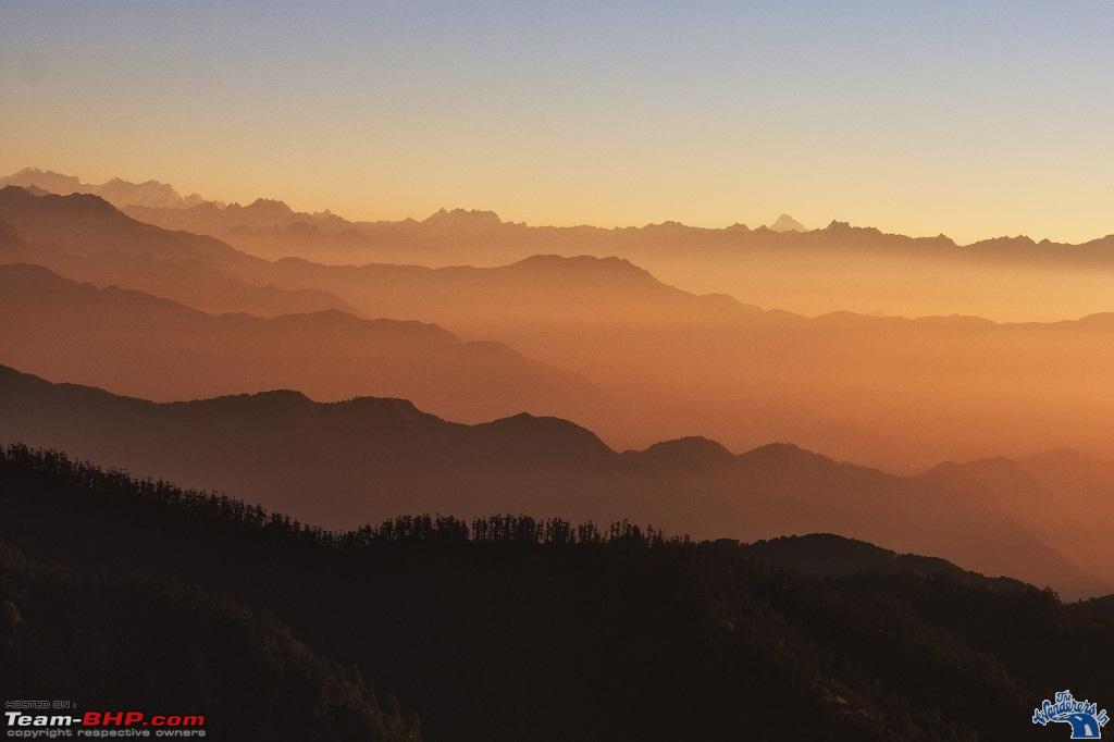
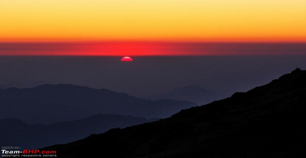
Morning sunrise at Phalut 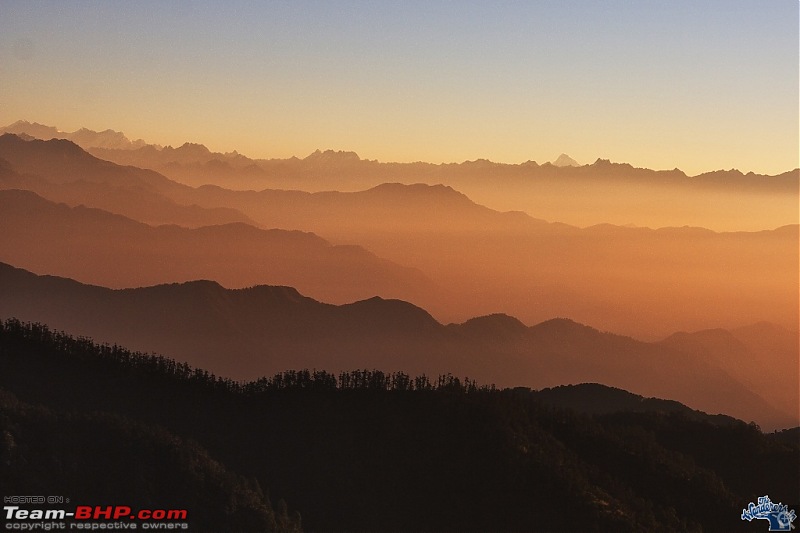 Kanchendzonga from Chitrey, en route to Sandakphu and Phalut -- Darjeeling district, W Bengal

More images as I take out from the card in the following days.
Journey to and fro was done through NH34 only, night drives. While going had numerous forced stops ranging from fog to disturbances to accidents, and took 16 hours to reach Siliguri.
Back journey was fast and trouble free, 12 hours of journey time with 1 hr break in between.
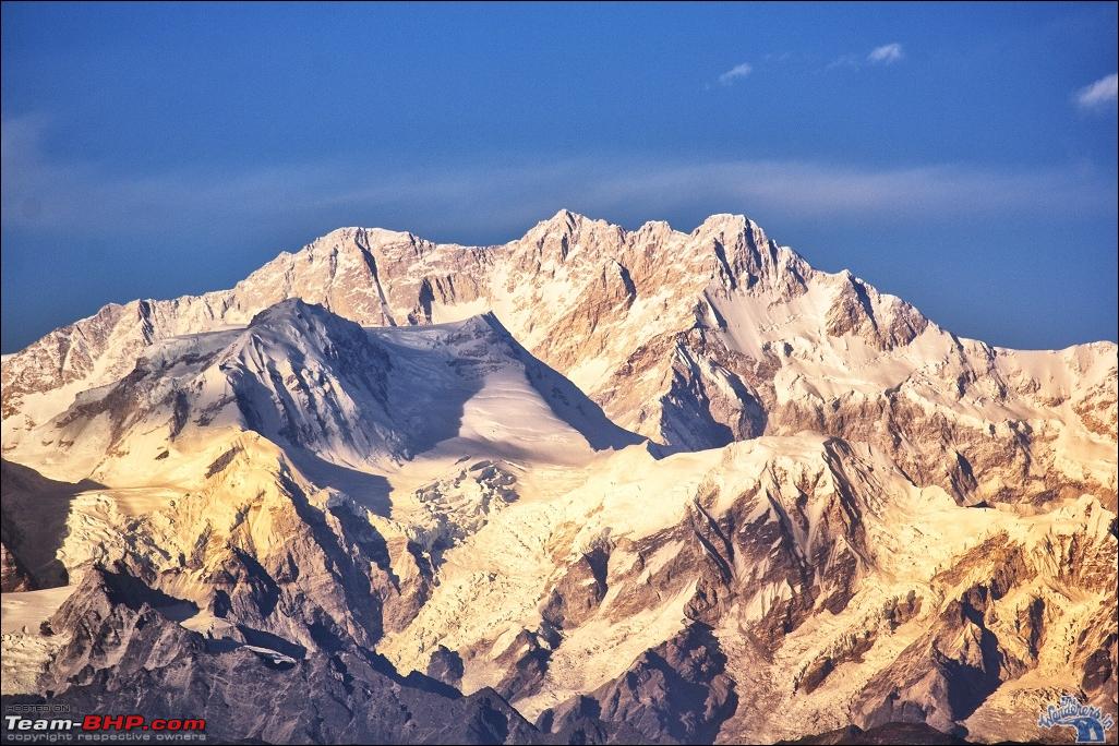
Kanchendzonga from Phalut, Darjeeling, W Bengal 
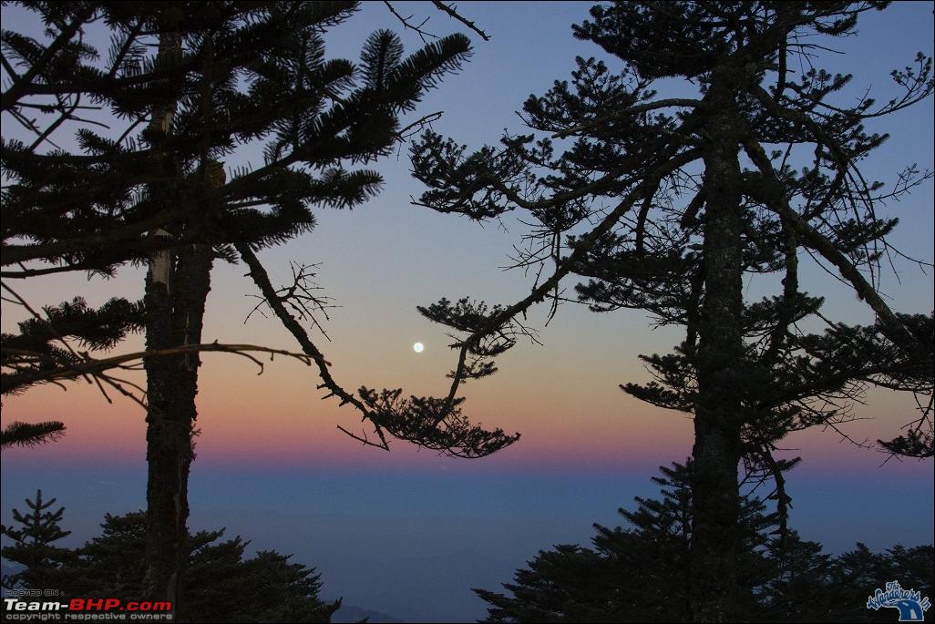
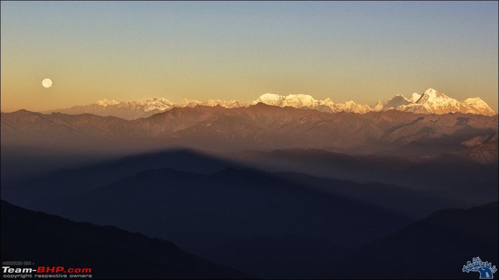
Moonrise at Sandakphu 
Moonset at Phalut, along the Mt Everest range. 
Quote:
Originally Posted by adc
(Post 3006209)
Journey to and fro was done through NH34 only, night drives. While going had numerous forced stops ranging from fog to disturbances to accidents, and took 16 hours to reach Siliguri.
Back journey was fast and trouble free, 12 hours of journey time with 1 hr break in between.
|
Awesome pictures ADCda. Have the road conditions improved or same as before?
Quote:
Originally Posted by A.G.The Rambler
(Post 3006898)
Awesome pictures ADCda. Have the road conditions improved or same as before?
|
Road condition is somewhat improved. Till Berhampur, road is okay with occasional potholes, which in fact you can predict if you had gone through NH34 quite a few times before!
After Berhampur to Moregram crossing, the road is between okay and bad. Speed is slow.
Again around Raiganj and Dalkhola though potholes are less, the way the roads have been repaired with patches - the patches itself make a bumpy ride.
Beyond Dalkhola no issues as one connects to double landed NH31.
For night drives, summary would be :
If you are going to Siliguri, follow the NH2 Burdwan to Siuri to Moregram to connect to NH34.
If you are coming back at night, follow all the way through NH34 - IF - there is no jam. Otherwise again via Moregram.
All said, if you get into jams, ask the local or follow the local drivers, they invariably know all the inner roads to bypass a particular jam point. Like while coming at 1030 pm after Raiganj was about to be stuck in a huge jam due to accident, asked a local and in between asking for the "high road" - another name for NH34 in local language - bypassed it in 10 mts - else would have been stuck for hours.
Final few pics.
Sunset at Phalut 
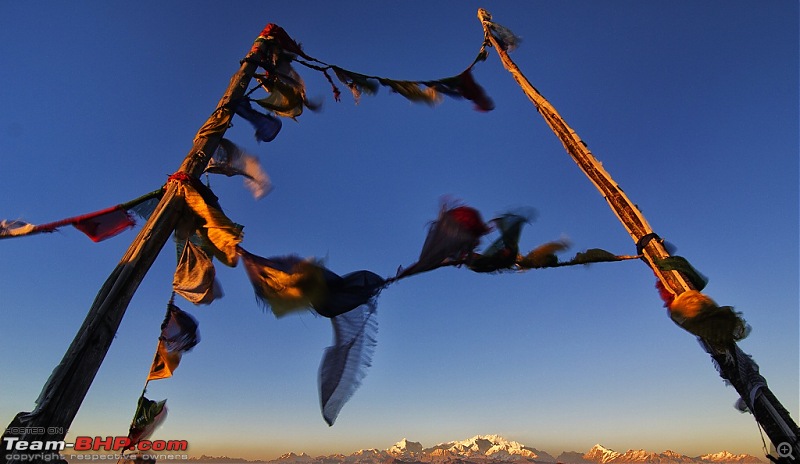
Kachendzonga view, morning, Phalut top 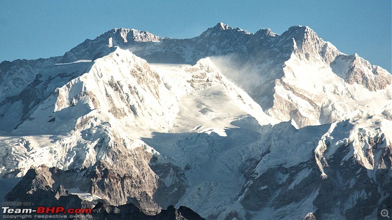 Prayer flags at Phalut top with Kachendzonga
Sandakphu, Darjeeling district, W Bengal 
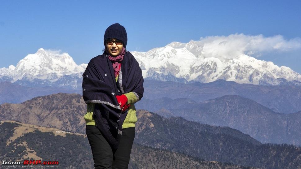
Mrs adc clicked by Master adc at Phalut top 
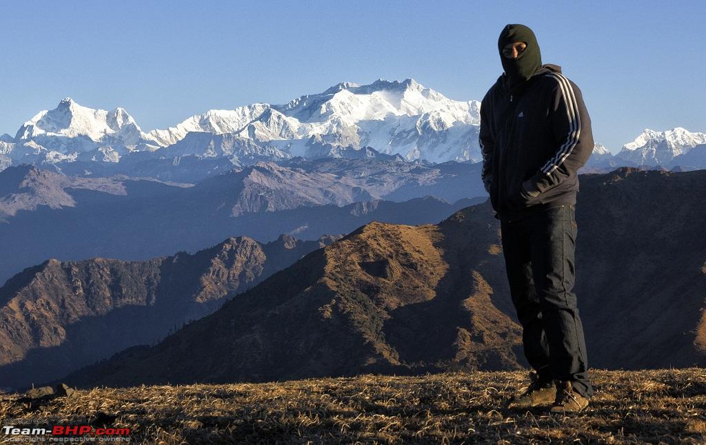
adc self shot at Phalut top 
| All times are GMT +5.5. The time now is 17:29. | |