

 27th August 2012, 10:11
| #271 |
| Senior - BHPian Join Date: Nov 2006 Location: Mumbai
Posts: 7,369
Thanked: 3,454 Times
| |

|  (4)
Thanks (4)
Thanks
|


| |
|
27th August 2012, 10:55
| #272 |
| Distinguished - BHPian  | |
|
|


|
27th August 2012, 11:07
| #273 |
| Senior - BHPian Join Date: Nov 2006 Location: Mumbai
Posts: 7,369
Thanked: 3,454 Times
| |
|
| (3)
Thanks
|
|
27th August 2012, 12:09
| #274 |
| Senior - BHPian Join Date: Nov 2006 Location: Mumbai
Posts: 7,369
Thanked: 3,454 Times
| |
|
| (9)
Thanks
|
 ) than he did himself!
|
27th August 2012, 15:01
| #275 |
| Senior - BHPian Join Date: Nov 2006 Location: Mumbai
Posts: 7,369
Thanked: 3,454 Times
| |
|
| (7)
Thanks
|

 -
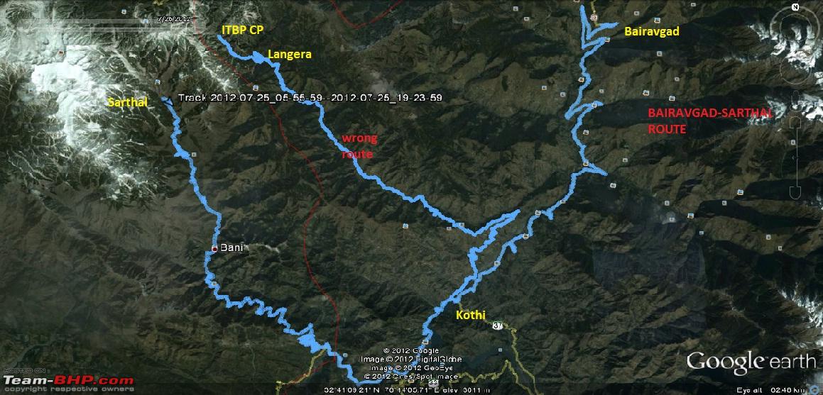
-  ) which Pak could shell or cut off, severing all road links from the Punjab plains with both Jammu & the Kashmir Valley further down. On the other hand, this road which we travelled on is sheltered between the Dhauladhar mountain ranges & hidden from any onslaught. Judging from the way the road widening was going on in the Kyari-Bani sector, I guess there must be some long-term plans to widen this road and make it motorable all the way to Doda and thereon to Srinagar itself. I will elaborate on this aspect more later. And getting this road into a civilised condition is not going to be easy as we find out as we drive further down this road......
|
27th August 2012, 15:53
| #276 |
| Senior - BHPian Join Date: Nov 2006 Location: Mumbai
Posts: 7,369
Thanked: 3,454 Times
| |
|
| (7)
Thanks
|

|
27th August 2012, 20:52
| #277 |
| BHPian Join Date: Jun 2008 Location: KA51
Posts: 271
Thanked: 644 Times
| |
|
| (9)
Thanks
|
|
27th August 2012, 22:09
| #278 |
| Senior - BHPian Join Date: Sep 2008 Location: Bangalore
Posts: 6,552
Thanked: 16,397 Times
| |
|
| (1)
Thanks
|
 all depends on you and laluks. I guess 750 odd I will reach soon, because, laluks sir has his ooty trip and this log is yet to complete also I have slowly come into terms of posting in technical and 4x4 section. So i guess anymore mile crunching will not be a problem.
|
27th August 2012, 22:25
| #279 |
| Senior - BHPian | |
|
| (1)
Thanks
|
 Sir, NH1A is one road to the top which was under huge media coverage during Kargil. This is not just the chicken-neck but was once the lifeline of the troops up in the forward posts.
 |
27th August 2012, 23:34
| #280 |
| Senior - BHPian Join Date: Nov 2006 Location: Mumbai
Posts: 7,369
Thanked: 3,454 Times
| |
|
|
|
28th August 2012, 13:34
| #281 |
| BHPian Join Date: Aug 2009 Location: Lucknow
Posts: 782
Thanked: 114 Times
| |
|
| (2)
Thanks
|
 .
.| |
|
28th August 2012, 14:04
| #282 |
| BHPian Join Date: Jun 2008 Location: KA51
Posts: 271
Thanked: 644 Times
| |
|
| (1)
Thanks
|
|
28th August 2012, 15:55
| #283 |
| Senior - BHPian Join Date: Nov 2006 Location: Mumbai
Posts: 7,369
Thanked: 3,454 Times
| |
|
| (3)
Thanks
|

|
28th August 2012, 16:22
| #284 |
| Senior - BHPian Join Date: Nov 2006 Location: Mumbai
Posts: 7,369
Thanked: 3,454 Times
| |
|
| (1)
Thanks
|

|
28th August 2012, 16:35
| #285 |
| Senior - BHPian Join Date: Nov 2006 Location: Mumbai
Posts: 7,369
Thanked: 3,454 Times
| |
|
| (7)
Thanks
|
 |
Most Viewed