Team-BHP
(
https://www.team-bhp.com/forum/)
-
Travelogues
(
https://www.team-bhp.com/forum/travelogues/)
Quote:
Originally Posted by SS-Traveller
(Post 3139900)
And a dear friend, a member of this forum, promised to join us for the trip,
|
??
Quote:
Ever so diffidently, not wanting to sound too greedy, I asked, would it be too much trouble to arrange for a 4wd vehicle?
We were in for a gigantic surprise at Guwahati airport, when this car drove up to meet us...
|
The wishes of a guest! And trepidation about luggage. In a Bolero, canned sardines would have called us cattle class.
Regards
Sutripta
Quote:
Originally Posted by Sutripta
(Post 3148821)
??
The wishes of a guest!
|
Indeed, for us it was
**!!** as a response. What we thought would be a co-traveller arrangement, turned out to be a host-guest arrangement without notice - not that that is any cause for complaint! :)
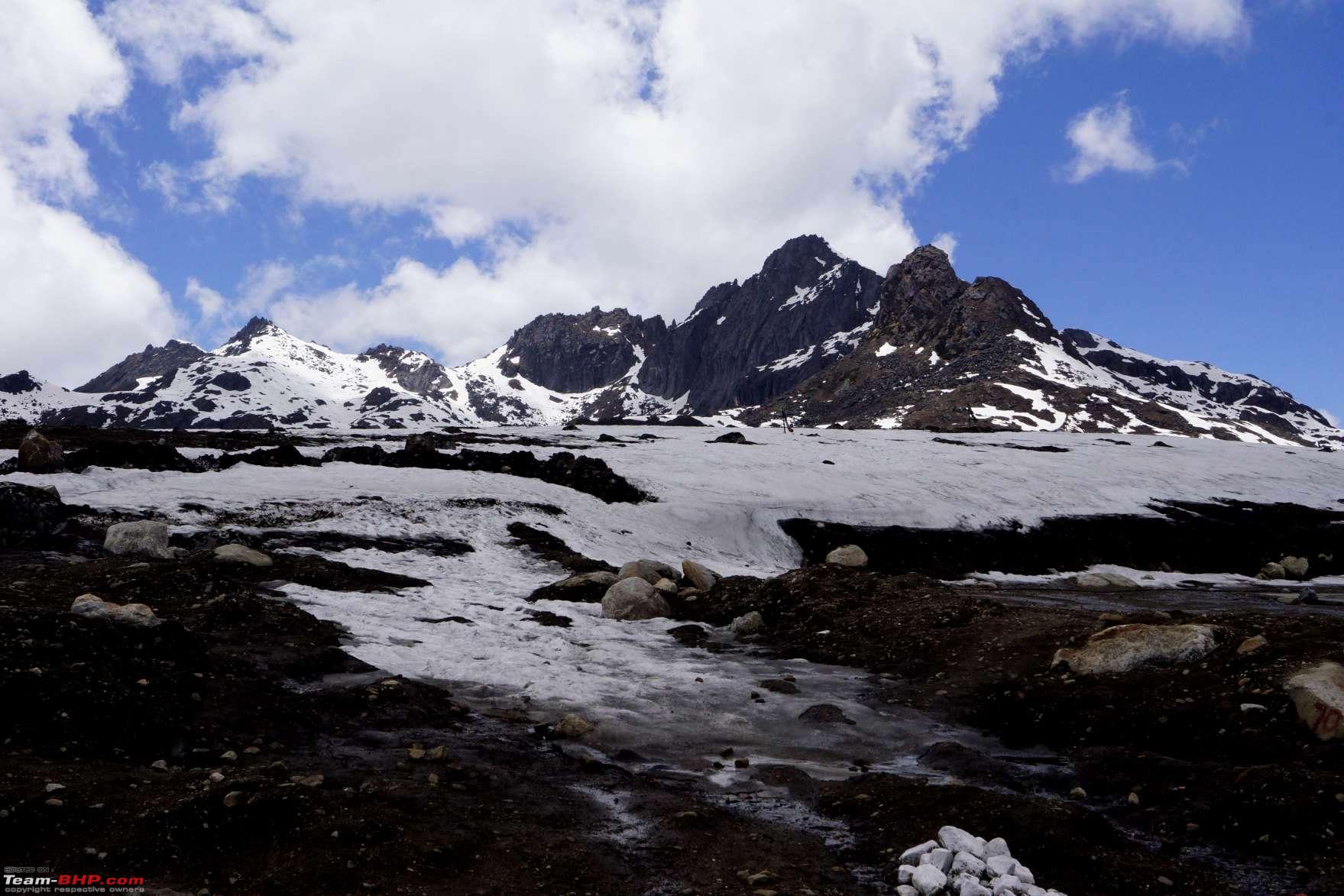
Now that the videos on the previous page have given you a fairly good idea of the condition of the road in general when travelling to Bumla and the Madhuri Lake, and knowing that we are travelling in a car that does not consider these roads to be tough or strenuous (4LL works wonders - no spinning wheels, no howling engines, no burning clutch plates, no using brute force and momentum to climb 30% slopes), let us enjoy the scenery as we climb to Bumla.
Tawang city scattered across the mountains far below
We are approaching a region where sub-zero temperatures are the norm, and the army uses
igloo-like huts made of FRP, for protection from the weather
The
vistas across the mountains are awe-inspiring
Tawang district has some 108 lakes according to the district's
official website, all of them located at more than 10,000 feet above mean sea level. The first lake we encounter is a heart-shaped little lake called the
Panggang Homa Tso.
Further along the road is the
Panga Teng Tso, also known as the Panggang Teng Tso, or in short, just the
P. T. Tso. This is one of the largest lakes in the region, and the details are listed on a recently-installed signboard. A long photography break here is definitely warranted! :)
Moving on from the PT Tso, it's a steady climb to the next pass, or
La on the road ahead - the Nagu La, or the snake pass.
And down below, not far away, glimmers the lake of the snake pass, the Nagula Tso.
Actually, the satellite view of the lake is equally impressive.
The location in the satellite view is the spot where we subsequently stop for another photography session!
Signboard carrying statistics about the lake 
More views of the lake and its surroundings
Fortuner in the lens! Time to move on. The two pools of the Nagula Lake stare back at us like
ethereal eyes.
The first sign of snow beside the road
Y-Junction, here we come.
Decisions, decisions. Turn right first for Bumla, or turn left for Madhuri Lake?
Imagination is more important than knowledge. ~ Albert Einstein
Imagine there's Heaven beyond Tawang. A Heaven filled with clear lakes and snowy mountains.
On Earth, each lake is expected to have a name. A name that lets us know which lake is where, who has visited it when, and what s/he thought about it. And others sitting in their cozy armchairs in other corners of the same Earth, get all their knowledge about the said lake without ever having visited it. They search for the name, and Google hunts it up from the worldwide web. And there are photos, statistics, likes, dislikes, discussions, movies, picnic huts and tea stalls made around each and every such lake.
But when it's a lake in Heaven, it is a mysterious lake with no name. You need to enjoy the beauty of the lake without needing to know its name. The lake doesn't want a name attached to itself. But who is to believe that? When Earthlings come and inhabit Heaven in small groups, they MUST name each and every lake they see. Such naming is of strategic importance if and when a war between mortals breaks out in Heaven.
So they climb on to a rock in the middle of the lake and paint a name. In this case, it's
KYALEM BARVA TSO. It could well have been named
Kya Fark Padhta Hai Tso. Try Googling the name of this lake and you'll know.
So what do
you want to name this lake?
Or this one?
Or even this one?
We actually drove through that last lake - remember the video on the previous page? So how about calling it the
Drive-through Tso? :D
http://www.youtube.com/watch?v=Wer4HGs5Nl8
Hi, very nice snaps and narration. Thanks for sharing the experience - waiting for next posts..
One observation - in last snap there seems to be anti slip mat on top of the air bag area - this would foul with deployment (hope not!) and is not advisable right?
Regards
Anand
It would sound rather gung-ho and would give you a vicarious thrill reading this if I wrote:
The engine howled in the rarefied air at 15,000 feet as it tried to breathe in whatever little oxygen was available, the turbo whistled like a screaming banshee, and the coolant tried hard to vapourize. The huge Dunlops scrabbled for grip on the gravelly surface with patches of mud and slush, as sharp edges of rocks tried to slash at the sidewalls and make mincemeat out of them, to prevent further progress. The gearbox groaned under the strain as the red hot clutch plate tried to mate it to the engine spinning madly at 3000 rpm. Progress was erratic, as the car bounced along the rocky mountain trail, with a sheer 500-metre drop to the right - one erroneous swing of the steering wheel would send us tumbling to our deaths below, in the metal coffin that was our car.

Truth be told: The Toyota Fortuner does not believe in dramatics. Drive to the neighborhood market or drive to Bumla, it does its job with mild disdain of its working conditions. It doesn't scrabble for grip, the throttle does not need to be floored (in fact, flooring the throttle actually caused a drop in power - though we don't really want to discuss the
why and
how of it on this thread), burning your clutch plate is absolutely your choice, power delivery is like turning on a fire hose and letting the water flow out - after a point you don't need as much power as it has - and at 14,734 feet, you haven't really crossed the 15k mark at Bumla.

In short, having the right vehicle and driver always ensures that you win. Remember that the next time you step out to buy a car! :D
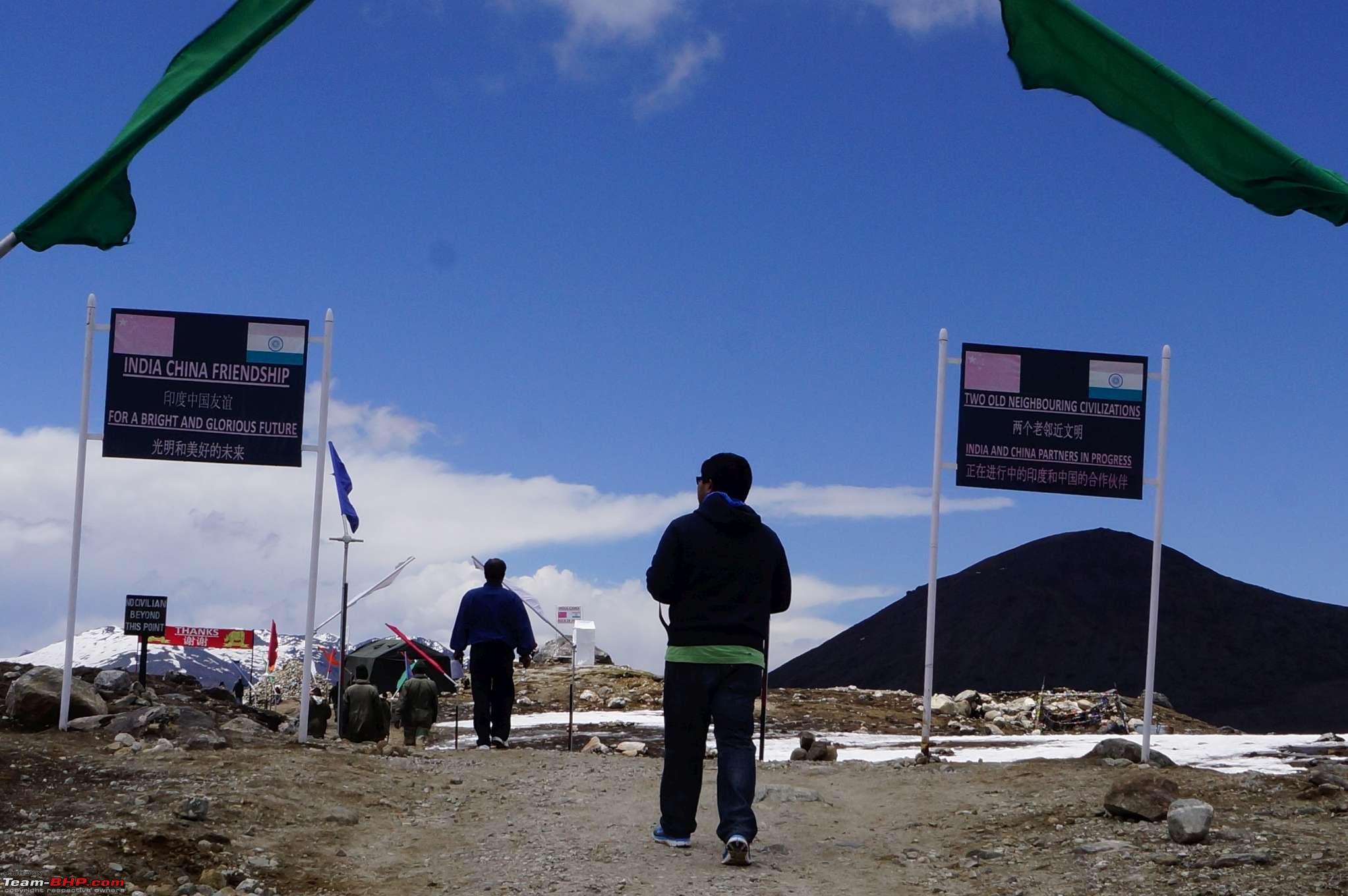
So here we are at Bumla, where, again for the sake of drama, we could be said to be eyeballing the hostile Chinese army facing us just a few metres across the international border between our two countries. But that isn't quite so, as you'll see later. For now, here's a glimpse of the place where we parked the car.
If you want dramatics, take a Sumo to Bumla. Even better, look for an Ertiga!


================================================== =====
Quote:
Originally Posted by adtalwar
(Post 3149692)
Hi, very nice snaps and narration. Thanks for sharing the experience - waiting for next posts.
|
Thanks for the appreciation.
Quote:
Originally Posted by adtalwar
(Post 3149692)
...there seems to be anti slip mat on top of the air bag area - this would foul with deployment (hope not!) and is not advisable right?
|
Wrong. A 25-gramme antislip mat will not restrict an exploding airbag, nor injure anyone if it flies into his face while the airbag deploys. Please don't worry so much.
Dear Sir,
You need to read this and there are other details available online as well:
http://drive2.subaru.com/Win06_whatsinside.htm
It is not safe to keep any object on airbag area as this can not only hinder the deployment but actually be more fatal than the accident as the object can transform into a flying missile inside the cabin.
Sorry to go into technicalities on your travel thread but it is not that trivial and shared with your safety in mind :)
Please carry on with your journey :thumbs up
Regards
Anand
Quote:
Originally Posted by adtalwar
(Post 3149788)
You need to read this...
It is not safe to keep any object on airbag area as this can not only hinder the deployment but actually be more fatal than the accident as the object can transform into a flying missile inside the cabin.
...it is not that trivial and shared with your safety in mind :)
|
Dear Anand:
Thank you so much for your concern.
As you rightly said, we shall not discuss this issue on a travelogue. You are free to open a fresh thread in the Technical Stuff sub-forum, and I shall be more than happy to answer your concerns there, as well as put your mind to rest that I always have the safety of my family, friends and myself in mind when travelling in a car.
Quote:
Originally Posted by SS-Traveller
(Post 3149154)
Indeed, for us it was **!!** as a response. What we thought would be a co-traveller arrangement, turned out to be a host-guest arrangement without notice - not that that is any cause for complaint! :)
|
Todays youngsters need to be shown their place in the hierarchy of things!
Regards
Sutripta
Quote:
Originally Posted by Sutripta
(Post 3149896)
Todays youngsters need to be shown their place in the hierarchy of things!
|
Hmm... what other places shall we talk about soon? And hierarchy and "iyarchy" (ইয়ার্কি) often go together in today's day and age! :D
================================================== =====
Quote:
Bumla Trade Point (Indo-China), location and its connectivity. Bumla is 37 kms away from Tawang. From Tawang to Y-junction is 22 Kms which is metalled and the rest 15 Kms is graveled which opens for 5-6 months in a year, i.e. June to October and from November to May the road communication is cut off due to heavy snowfall. This road is one of the shortest connectivity points to china from Tawang (India). In the Chinese side, the geographical terrain and landscape is far better than Indian side. Shyo (China) is 3 Kms, Kachin- 5 Kms, Dengding 6 Kms and Nyagdo 8 kms from Bumla. The nearest major town of Chinese side, Tsonajong is 43 Kms from Bumla border post. It is a district HQ town as well as Brigade HQ connecting Gordung-Lhasa-Beijing trunk Highway. It is connected by all weather metalled road to Tsethang (district HQ in Tibet, China) by a distance of 508 Kms from Bumla (India).
Source
|
Across the border, one finds a lovely all-weather road leading away. And of course, there is no crowd of tourists ogling at us from the other side. The blue building is our neighbours', as is the round white observation post on top of the mountain.
I suppose the men over there must be laughing their heads off all the while, looking at the curiosity of hundreds Indian tourists swarming every day all over a solitary point on the McMahon line that defines some
1,030 km of the border that Arunachal shares with China.
On the Indian side, there's a lot of pomp and show - there's the Hall of Friendship where meetings are held twice a year...
...there's the heap of stones for Sino-Indian friendship...
...and there's the India-China rock of peace next to it.
A few more photographs from Bumla...
We are now on our way to a beautiful lake with a lot of controversy over its name. But first we have a problem. More like, a couple of problems.
The first problem is one of
AMS. At almost 15k feet at Bumla, it's not unexpected. But when your better half gets it, you feel like the worse half (or much the worse off! :) ). The quickest way to set things right for a short while is a supply of oxygen. Strangely, there's none available. The other solution is to get to a lower altitude. The lake is at 12,242 feet. Would that make a difference?
The other problem is one of time. There are certain time restrictions that the army imposes:
- You need to cross the first checkpost when travelling out of Tawang by 11 AM.
- Y-junction needs to be crossed by 1 PM for going to either the border or the lake.
- You need to be back at the Y-junction and headed back to Tawang by 3 PM.
By the time we are back at the Y-junction from Bumla, it's a little after 1 PM. We are told to be back by 3 PM. The AMS symptoms seem to have settled down to an extent, but the bumpy road isn't helping.
A couple of army personnel want a lift till their unit. We pick them up.
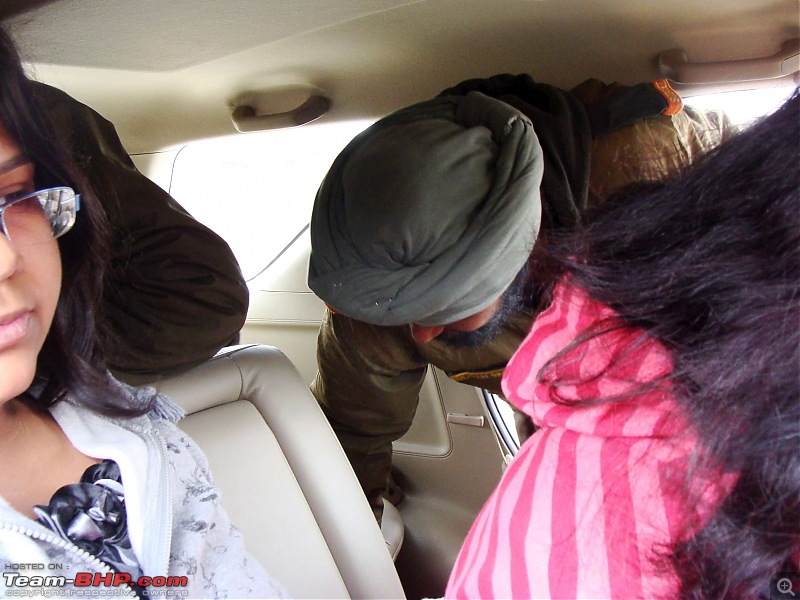
The wife isn't feeling too well again. The army folks are very sympathetic. They want to help, and ask us to stop at their unit for a while. We stop for some tea, and they try to find us some medicines.

While we take a break, Sutripta-da and I utilize the time to inspect the behemoth next to which we had parked. It's of Korean make, with push-button controls - makes us wonder how durable the machine would be under such arduous conditions, and how much of spares & service support might be available. And it would have been a mind-bogglingly tough exercise to have moved the machine to this place.
We are still worried about the time. The army folks reassure us that it would not be an issue, if we told them that we stopped here for medical help. We bid goodbye to them and are on our way to the lake.

We've stopped for long enough to take in the ABUADANCE of life, as well as some excellent tea.
Quote:
Originally Posted by SS-Traveller
(Post 3150843)
...a beautiful lake with a lot of controversy over its name.
|
Madhuri Dixit, one of Bollywoods most famous faces till recently, has sparked a row in Arunachal Pradesh. Not the actress but her first name which is being increasingly used by non-locals to refer to a natural lake that became a much sought after tourist destination after the success of her movie Koyla in the nineties.
The area was known as Tser, which means grazing land. The villagers used to pay five coins to the landowner for according them traditional rights to graze their cattle. Until 1996,the lake was known as Tsho-nga Tser, but soon after Rakesh Roshan shot the film on location, the soldiers started calling the lake after Madhuri.
Local armymen also started calling the Tsho-nga Tser lake by Madhuris name. But it has left the local Gelukpa sect, primarily followers of Tibetan Buddhism, fuming.
Once a forlorn but picturesque area only 40km from Tawang, the lake is snowbound for most of the year. Formed after the earthquake of 1950, the lake became abuzz with tourists after the Shah Rukh Khan-Madhuri Dixit starrer became a huge hit.
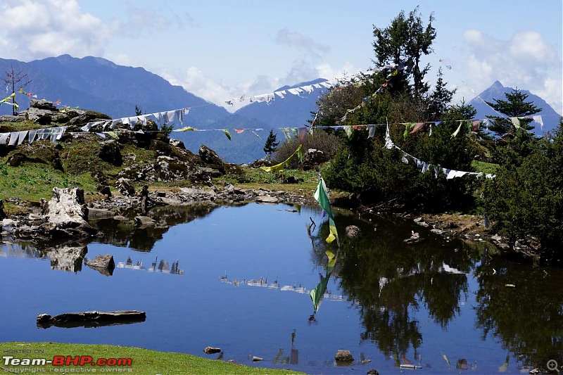
We snake along the curvy and scenic road to the lake...
...but before we reach, here's a satellite view of the lake.
The Sho-nga Tsier lake is indeed beautiful. The photographs really do not do justice to the mystic aura surrounding the area. The leafless and lifeless tree trunks jutting out of the water lend an eerie feeling to the scenery.
The cafe beside the lake seems to be a good place to relax and spend some time sitting out on a sunny day, but we were pressed for time and could not indulge in that luxury.


Plenty of yaks continue to graze here - after all, this was their grazing ground for unknown centuries!
| All times are GMT +5.5. The time now is 06:15. | |