| |||||||

 |
| Search this Thread |  11,524 views |
 31st October 2013, 22:03
| #16 | |
| BHPian Join Date: May 2013 Location: India
Posts: 143
Thanked: 465 Times
| Re: Alto'ed: Old Silk Route, along the footsteps of great explorers into Little Tibet Quote:
| |

|  ()
Thanks ()
Thanks
 |

| |
|
7th November 2013, 18:57
| #17 |
| BHPian Join Date: May 2013 Location: India
Posts: 143
Thanked: 465 Times
| Re: Alto'ed: Old Silk Route, along the footsteps of great explorers into Little Tibet Sorry for the delay friends, here is one at last, many more to go... Alto'ed: Old Silk Route, along the footsteps of great explorers into Little Tibet. Day 2, Sunday (contd.) Part II. So to continue from where we left, we had reached Tshomgo Lake at an altitude of 12,400 ft AMSL by around 9:20 AM, thus taking about 1 hr and 50 min of relaxed photography indulgent drive. And now we were deciding whether to stop here now or continue now and stop on the way back. Well, this line of discussion took place many a times during the trip. So after this particular discussion, we decided to continue towards Nathula and reach there as early as possible. Continuing ahead of Tshomgo Lake  The scenery around now was surreal and beautiful; light smoky mist floating in and out, bright white puffy small small clouds, pure haze free bright blue skies, bright sun beams on beautifully wooded slopes which were rimmed by craggy rocky bastions.Rare Colours of Lichens / moss on the slopes The slopes themselves were covered with beautiful conifers, rhododendrons and variedly hues lichens and mosses. I had never ever thought that such kind of colours were possible in nature. 6 kms further on travelling along such beautiful scenes or about 40 kms from Zero Mile, Gangtok we reached the market town of Sherathang at around 10:10 AM. This is the town till where the traders from across the border from Tibet and China come into India via Nathula. They sell their stuff her and buy from here. Wife was excited about seeing this place when I had told her about it during the trip today. But alas, it appeared closed when we reached there. And as I had the Nathula fever riding in my head, we continued ahead without stopping and exploring here. This made the wife a bit grumpy, even though by the look of it, the shops did appear all closed! This place seemingly also has the "World's Highest Permanent Cyber Cafe" at 13,600 ft. Sherathang Market Settlement, settled in nature's fold. 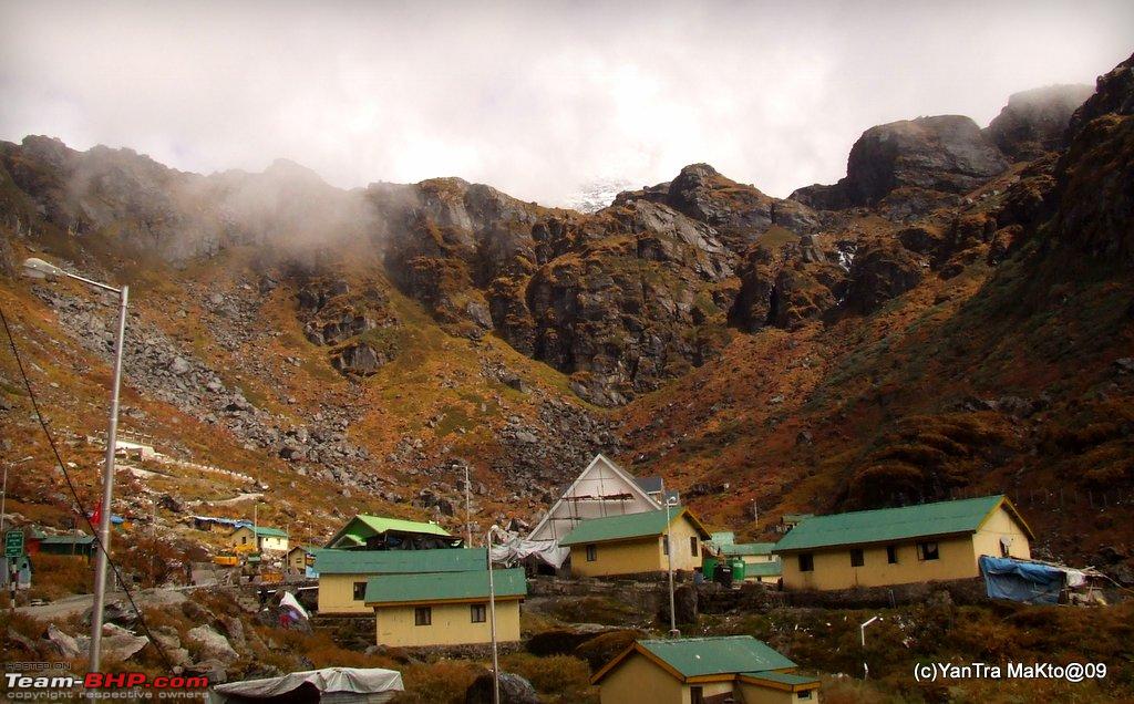 Close Up of views hiding behind the clouds beyond the natural rocky walls of the settlement  We continued towards Nathula. And photo stops were getting more and more frequent. We came across Ribbon Type Lakes of a minute scale. Ribbon Type Lakes on the way to Nathula  Also on few faraway slopes, there were patriotic slogans like 'Mera Bharat Mahaan' written in a gigantic scale. After about 47 kms from Zero Mile, Gangtok we reached a fork in road where a road was bifurcating and going up towards the left and had a decorative gate over it, while the other branch appearing as the main road continued straight and level. Well, there was a sentry post there and I made the entries in the registers. Well from being the 4th to enter at 5 mile check post, we had become the 11th now. The sentry told us that the relatively minor looking branch going up led to 'Nathu La'. I always thought that Nathula would be at the end of single minded road i.e with no major branches of the road, as it crosses over to Tibet. But now I was bit surprised to find that the road to Nathula appears to be branching off from a main road. We asked the sentry at the post about this other but seemingly main road, as to where does it go and for how far. He was surprised that we did not know about 'The Baba Mandir'. He told us that about 2 km further on that road, there was the New Baba Mandir. But he was very sceptical about it, and in his honest opinion, he did not really like the place and its touristyness, In his opinion that since we had come so far and in pretty good time of the day, therefore we had go to till the old and original Baba mandir, which as per him was about 12 kms away from here. So after taking all this information from him, we continued on our way towards Nathula for now. And soon we had a glimpse of a red roofed pink building on the ridge line far away and thought that that must be Nathula. View of Nathula  Well, Nathula it was, as we discovered soon. After about 4.5 kms from the bifurcation, and some steep climb, we reached the Nathula at around 10:35 am i.e about 3 hours of exciting drive in scenic surroundings. Since we were among the early ones reaching there, we had the privilege of parking our vehicle pretty close to the Nathula Complex. Privilege of parking up close  We realised this only when we were going back and saw that vehicles were being stopped and instructed to park on wide sections of roads a couples of hair pins bends below. But still we were not allowed to even see the Nathula Gate or the actual road going over the pass, it was a bit of disappointment as I had wanted to see and click it, if possible with my Alto in foreground. Any way, there still was lot to do and enjoy. I was denied of this opportunity  As we got out of Car at Nathula, the first thing to hit us was the chill. What with some clouds enveloping the pass. The chill brought out the natural reaction and thankfully I found a place to relieve at 4310 mtrs (14,140 ft) AMSL. Now regarding the height there is always a confusion of 100 / 200 fts in the mountain regions. As per the army and tourism boards at Nathula the height is 14,420 ft and 14,400 ft. While as per Sikkim government website it 14,450 ft. Somebody with any clarification regarding the real actual height! Taking turns to look after the kid.  The visibility reduced suddenly, and was back to good in matter of minutes. A reminder of how fickle the weather can be in these high passes. The Nathula Complex had a memorial to the soldiers of the Nathula Battle of 67 and conference building presumably for holding flag meetings etc. The building's hallways also had some black and white photographs of few important events of / visits to Nathula. And to our delight, especially the kiddo's we had some remnant snow at Nathula. Well, though I have seen and experienced lots of snow and heavy bouts of snowfall too. But this was the first time for the wife and kid to experience snow up close. Though not fresh but thankfully it still was white and not muddy / dirty. Kid discovering snow  Well, Nathula 'appears' to be a very friendly border, with the the Chinese Building and Indian one built literally on the same platform. But I guess, there must be lot going on to keep the appearance of friendliness visible. Between the two countries there is just a barbed wire here. No no man's land. And the barbed wire also is dilapidated down to below knee level. And interestingly as the hoards of tourist climb up to Nathula, the Chinese soldier too appear, climbing down / up from their posts / rest rooms. It probably must be the only form of entertainment for them too. As the Chinese came down, the scene was more like what is generally found in a zoo, with group cheers and whispers when some exotic animal decides to show himself to a group of picnickers. It was common to find people posing for pictures with the Chinese soldiers in background, and we too did so!  But what happened now was not so common. While I was taking the pic above. One of the young Chinese soldier asked in sign language for a photo with our kid and handed over his camera to my wife, and before I could react she handed over the child across the border in the hands of the young Chinese soldier, and merrily got busy in clicking his snap with our child with his camera while he posed with the kid, they were even reviewing the snaps too together and tried out one odd more till it was to their satisfaction. But horror of horrors, the Jawans on our side got all tensed and a senior looking Indian soldier alerted the rest of our soldier while he started scolding my wife in Hindi without his tone implying any tension and told her to get back the kid immediately but naturally without seeming alarmed. She too felt the increased tension but thankfully was smart enough to get back the kid smilingly. And as the kid was back she got a nice dressing down from the senior looking soldier, and citing worst possibilities like what would you have done if he had just ran away with the kid and never trust the Chinese. Phew, some release and relief that alls well that ends well. Even to this day, it gives me goosebumps to think about the incident and thank God that nothing untoward happened. But anyway on the lighter side, our young is now unofficially China return. Now time for some pictures to do the talking A view of the Chinese side  That is the mountain bang opposite on the Chinese side. And the photo is in full colour, not black and white or monochrome ! A mountain white and black  Another view of the Chinese side  A Chinese soldier is seen lugging up some stuff to his post probably May be up there is his post. A rather tough walk. A Chinese Post  More Chinese and more posts  You can see one in with some long range kinda binocs too. And you see the wall, well I observed one Punjabi Mom telling her teenage kid in all earnest "Look! The Great Wall of China".  . Poor kid. . Poor kid.By this time, the place was getting swamped with tourist and with all the exclusive photo session over, all scenes to see seen, we decided to head back down, especially in the view of increasing crowd cover and decibels. One video view of the crowd by the time we left See the hairpin bend in centre of the frame at about 00:01, that is where the vehicles were now being parked. And then see the white gypsy at 00:09, well just below that is where we were parked. We were lucky to have reached early and thus enjoyed the place in relative calm and peace. So after spending about 40 odd mins at 14,400 ft, we started heading back and down by about 11:15 am. Heavy work requires heavy machines  Colours are matching matching. Twin Lakes close to Nathu La  What was surprising is that though both the lakes apparently appear connected but the top one is black while the bottom one is lighter. Explanation, someone! One Last view of Nathu La  A defining pic  Mountains, Mist, Clouds, Sunshine, Thin Ribbon Lakes, Big Lakes scattered all around, Dusty Muddy Roads and my Alto to be continued . . . |
|
| ()
Thanks
|
|
14th November 2013, 19:20
| #18 | ||||
| BHPian Join Date: May 2013 Location: India
Posts: 143
Thanked: 465 Times
| Alto'ed: Old Silk Route, along the footsteps of great explorers into Little Tibet. Alto'ed: Old Silk Route, along the footsteps of great explorers into Little Tibet. Day 2, Sunday (contd.) Part III. Reaching down to the road fork to Nathu La, we decided to set course towards the Baba Mandirs as advocated by the sentry. We decided that we will go as far as we can till 1:30 pm and then start heading back to Gangtok. We employed a time based strategy like this many a times during this trip. Because as we had decided that the main aim was to enjoy with the secondary aim being reaching a particular destination. Such flexible guideline for our own selves also ensured that we did not push ourselves unnecessarily. As the day closed to noon, the clouds had lifted up and there was nice bright sunshine making for a 'suhaana mausam'. The road though narrow was metalled, the gradient easy and the curves wide. It was a real pleasure driving on this road hugging along the contours where mountains met the high altitude verdant valley. Lovely Drive, on the way to New Baba Mandir  Another intresting incident here, I had collated a CD of my personal choice of music for drives, which was playing continuously during this trip. The shuffle mode of the player was on through out, and many a times the random shuffle delighted us by playing exactly apt number. Well it had now started playing 'Yeh Haseen Waadiyaan' from the film "Roza" ! Yeh Haseen Waadiyan  A video to depict the sweeping curves gradually sloping down from Nathula to this wonderful series of valleys. Waterfalls like these were dime a dozen in this heavenly place.  New Baba Mandir in panoramic settings 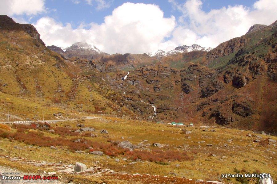 By about 12 noon, we reached the Harbhajan Baba Memorial. The drive was about 8 kms from Nathu La. The Harbhajan Baba Memorial Complex popularly called as the New Baba Mandir is said to have been made for tourist convenience, as the original or Old Baba Mandir is a bit farther and bit off track. It has been reconstructed at the junction of Kupup Gnathang road and the trail leading to Menmecho Lake, on November 11, 1982. About Late Baba Harbhajan Singh  Few more snippets about the legend of Baba Quote:
Quote:
Quote:
At the New Baba Mandir  The Prayer Hall  The New Baba Mandir  The waterfall is starting of the stream leading to Menmecho Lake The green buildings visible above opposite to the memorial contains a shop run by AWWA store selling nice little curios like this below. I have scaled Nathula  Also for a nominal donation fee, one can get a nice colourful certificate signed by the senior most army officer of this area as to having visited this area. We got one signed our son. Somehow, the certificate is kept somewhere safe for now and I do not have a pic of it. Will post as and when it resurfaces. Certificate for our boy Next to it is a Cafeteria called as "Cafe 13000". It provides a welcome cup of hot tea along with some snacks depending on availability. It employs local people thus providing them some source of income. At Cafe 13,000 with dressed up locals  The seating area of Cafe 13,000 overlooks the beautiful valley of Memencho Lake. The track at the lower left corner of the Memorial Complex pic above leads to the Memencho Lake. The Valley of Memencho Lake  About Menmecho Lake Quote:
Here is a video to wind up this post Video of Harbhajan Baba Memorial to be continued ... Last edited by YanTra Makto : 15th November 2013 at 09:09. Reason: Under construction | ||||
|
| (2)
Thanks
|
| The following 2 BHPians Thank YanTra Makto for this useful post: | GTO, Rehaan |
|