| |||||||

| Search Forums |
| Advanced Search |
| Go to Page... |
 |
| Search this Thread |  11,527 views |
 12th October 2013, 17:22
| #1 |
| BHPian Join Date: May 2013 Location: India
Posts: 143
Thanked: 465 Times
| Alto'ed: Old Silk Route, along the footsteps of great explorers into Little Tibet Alto'ed: Old Silk Route, along the footsteps of great explorers into Little Tibet. Teaser Well, it is the season time, with many a tbhpians heading for LEH. Also, the Maruti Raid De Himalaya 2013 has just come to an end. With so many excellent travelogues of excursions into Leh, I finally got motivated to pen down (rather type out) one my most memorable travel trips ever. This involved a single vehicle self driven adventure in a 800 cc hatchback (The Alto) accompanied by dear wife and our then 1 and a 1/2 year old son to the edge of the Roof of the World and back. Prelude How it all Started Since childhood, I have had always been fascinated with stories of Kailash Mansarovar, this slowly led to a fascination and general interest in all things related to Tibet. As I grew up, learned that there is a place in India called Ladakh with Leh as its capital which is as good as (if not better) Tibet and Lhasa. But alas have not yet been able to get Leh'd. Later on in life, perhaps when visiting Rohtang, learnt that there a region known as Lahaul & Spiti in Himachal too; which is across the Himalayan Water Shed (rather Himalayan Rain Shed, as we have many rivers cutting through the Himalaya proper). Still later on, do not exactly remember when, where or who, but sometime somewhere someone mentioned that even in the Northern parts of Sikkim, we have a small area with terrain similar to Ladakh (the bigger brother) or let us say Tibet (the original mai baap)! This small nugget of fact got enlodged in that permanent treasury of important information in the storehouse called brain. The keeda was born. (One among the many other Keeda(s)) How it finally materialized Cut forward to year 2009. An opportunity arose, where in I had the liberty to take a week of unplanned holiday. We decided to visit Gangtok, it being a highly recommended tourist hotspot, where we had not been to. After deciding that it is going to be Gangtok, decided to self drive and enjoy. With the time available in hand being more than what was required for just Gangtok, I started contemplating modified itineraries, viz. combining with Darjeling / Kalimpong / south / west sikkim. But then suddenly the Keeda (Little Tibet in North part of Sikkim) resurfaced. Searched for it online and whatever little I saw excited me no end. Discovered that there is a Lake called GURUDONGMAR which was among the highest lakes in the world. Made a rough mental itinerary for a week, which was largely flexible with lot of 'may do' and 'if not then' options. The aim being to enjoy the holidays rather than getting stressed out in trying to stick to definite plan with lots of touristy key points to be ticked. Well, enjoy we did and here is a trailer of how Trailer Day 1 Route: Mongpong Forest Resort - Coronation Bridge - Teesta Bazar - Melli - Rangpo - Singtam - Gangtok. (Within Gangtok : Namgyal Institue of Tibetology - Duddul Chorten - Ridge Park and Flower Hall - MG Road) Distance Covered: ~ 134 kms Maximum Altitude: 1835 mtrs Minimum Altitude: 180 mtrs Duddul Chorten, Gangtok  Day 2 Route: Gangtok - Serbathang Mart - Nathu La - Baba Memorial - Kupup - Baba Mandir - Water shed Memorial - Tsongmo Lake - Kyongsala Falls - Gangtok Distance Covered: ~ 142 kms Maximum Altitude: 4310 mtrs Minimum Altitude: 1700 mtrs Tsongmo Lake 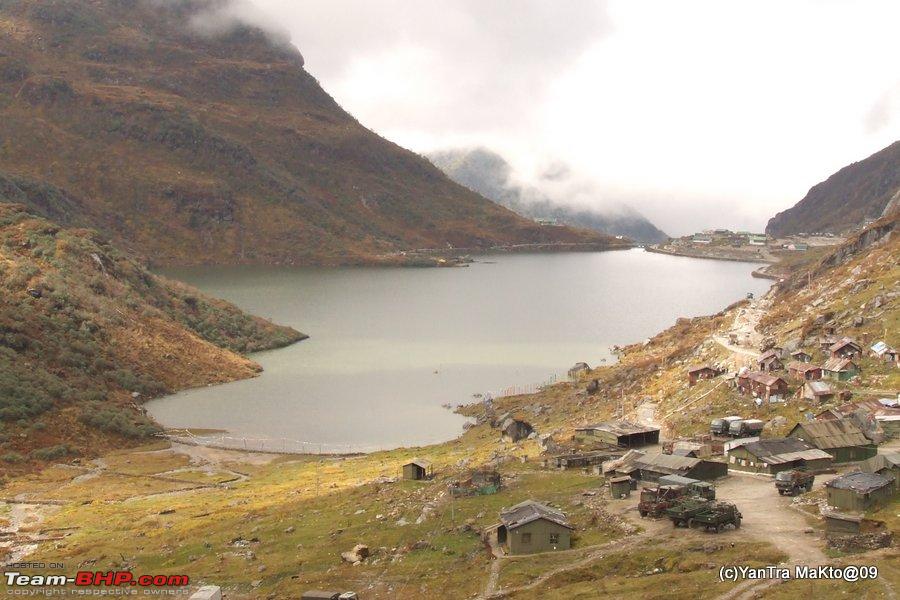 Nathu La  Baba Memorial in Scenic Setting 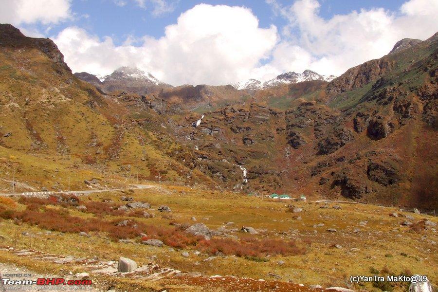 Kupup 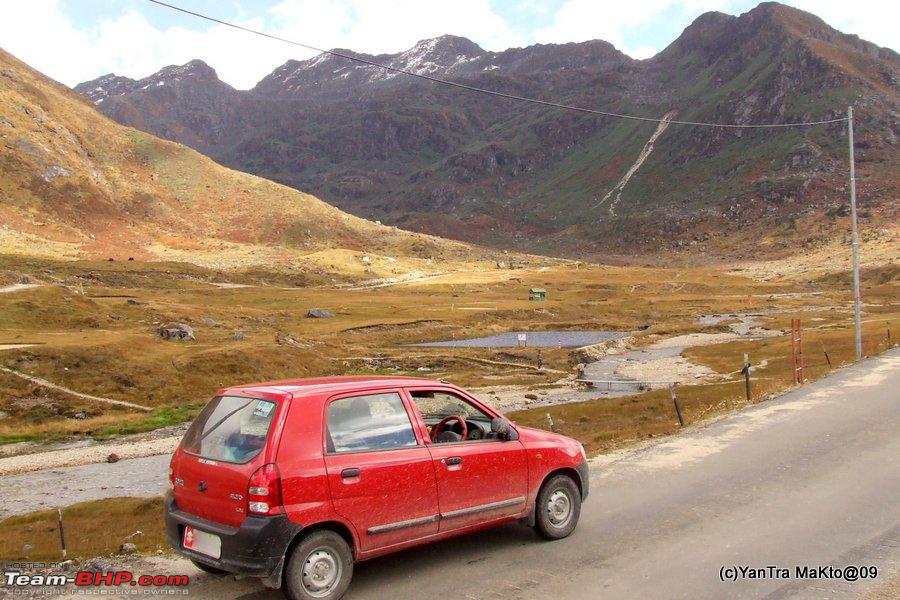 Day 3 Route: Local Sightseeing in Gangtok : - Tashi Viewpoint - Himalayan Zoological Park (Gangtok Zoo) - Ropeway - Hanuman Tok - MG Road Distance Covered: ~ 74 kms Maximum Altitude: 2225 mtrs Minimum Altitude: 1480 mtrs Snow Leopard, Himalayan Zoological Park, Gangtok  Rope way, Gantok  Hanuman Tok 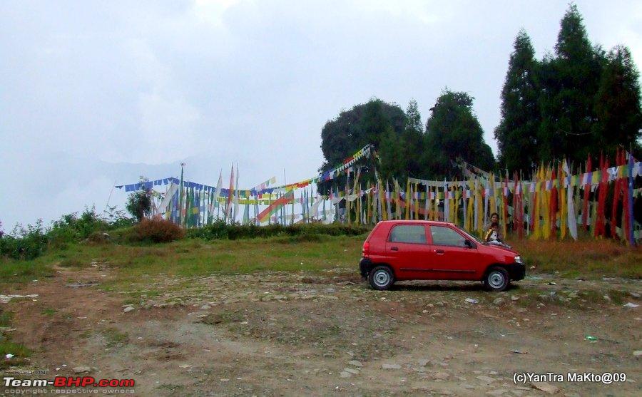 Day 4 Route: Gangtok - Kabi Lungchok - Seven Sisters Waterfalls - Phedong - Mangan - Naga Waterfalls - Chungthang Distance Covered: ~ 118 kms Maximum Altitude: 1895 mtrs Minimum Altitude: 775 mtrs Kabi Lungchok, North Sikkim  Naga Waterfalls, North Sikkim 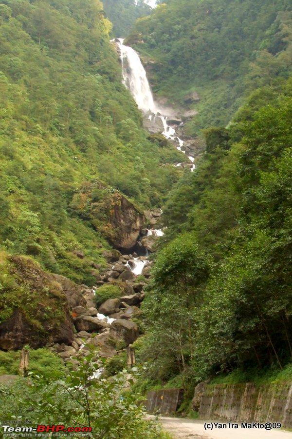 Day 5 Route: Chungthang - Bhim Nala Waterfalls - Lachung - Singba Rhododendron Sanctuary - Yumthang - Shiv Mandir - Yumthang - Lachung - Chungthang Distance Covered: ~ 114 kms Maximum Altitude: 3980 mtrs Minimum Altitude: 1580 mtrs Bhim Nala Waterfalls, En route Lachung from Chungthang 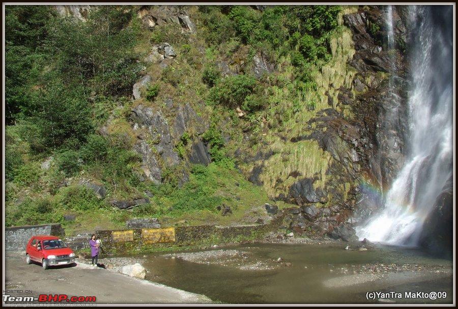 Lachung coming up... 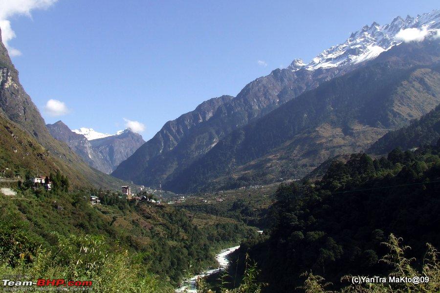 At Yumthang (Sikkim's Valley of Flowers)  Day 6 Route: Chungthang - Gaigong - Gurudongmar - Gaigong - Thangu - Lachen - Chungthang Distance Covered: ~ 170 kms Maximum Altitude: 5210 mtrs Minimum Altitude: 1580 mtrs Pristine Heavenly Gurudongmar Lake  Drive of a Lifetime 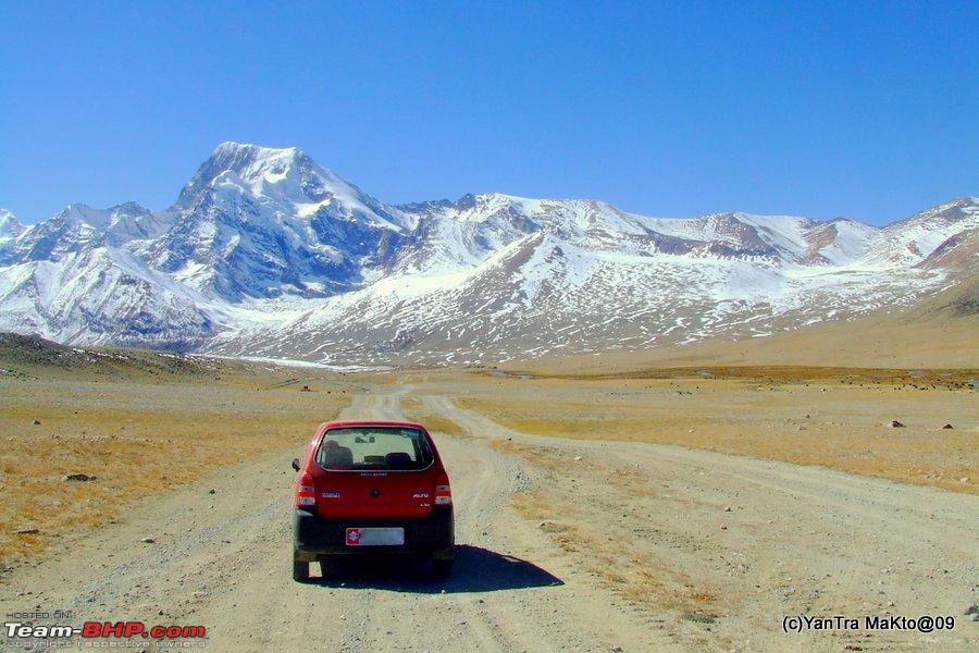 Day 7 Reverse of Day 4 Day 8 Reverse of Day 1 That's all Folk for now; Picture abhi baki hai mere dost To be contd... Last edited by YanTra Makto : 13th October 2013 at 11:49. Reason: Under construction |

|  (11)
Thanks (11)
Thanks
 |
| The following 11 BHPians Thank YanTra Makto for this useful post: | Ddrive, dkhatau, Gansan, GTO, khoj, phamilyman, Rehaan, rrsteer, rulerofsun, Samba, sdp1975 |
| |
|
14th October 2013, 18:33
| #2 | |||
| BHPian Join Date: May 2013 Location: India
Posts: 143
Thanked: 465 Times
| Re: Alto'ed: Old Silk Route, along the footsteps of great explorers into Little Tibet Alto'ed: Old Silk Route, along the footsteps of great explorers into Little Tibet. Thank you for going through the introductory post above. So to continue, before starting we got our 'kit' ready. In addition to generous amount of winter clothing especially for the kiddo, it contained these items, few of them extra as compared to our normal travel trip. - Standard tool kit provided with car.(Note: Where as rest are more of an emergency / pleasure measure, but whenever I travel I always carry an Extension cord/multi pin/spike buster. It comes in very handy to charge laptop, cameras and sundry. And whenever travelling by car, we also carry our electric kettle & it proves literally life saving at times, especially with kids around.) What I did not had - Any kind of GPS or navigation device. So, now that we are all set here starts our journey in detail. Decided to do a night halt at the Mongpong Forest Resort of WBFDC on Friday night due to three reasons. One - The trip starts from Friday evening itself. Two - Can hit the hills early even after a relaxed start on Saturday. Three - Better to spend the night at Mongpong than at house !. Day 1, Saturday Route: Mongpong Forest Resort - Coronation Bridge - Teesta Bazar - Melli - Rangpo - Singtam - Gangtok. (Within Gangtok : Namgyal Institue of Tibetology - Duddul Chorten - Ridge Park and Flower Hall - MG Road) Distance Covered: ~ 134 kms Maximum Altitude: 1835 mtrs Minimum Altitude: 180 mtrs We got up in the morning at a holiday-ish time of around 0720. And after freshening up and having the morning cuppa tea; self and son went for a stroll around, as wife was busy repacking her part of luggage as she wanted to rearrange stuff based on their likelihood of requirement. Finally, after she was done, I loaded up the car, taking care that I have sufficient view available from the rear window. Finally we were able to set course by about 0830 hrs. I utilized the in between time to get some breakfast packed. View while we strolled  On the horizon is Teesta River. The thin whitish line is the the sandy river bed. And the small cliff like line running above the white line is the bank of the river at far end. Distance between Mongpong and Gangtok is close to 93 kms and should normally take about 2 and 1/2 hours to 4 hrs depending on road and traffic condition. Google map view of Mongpong Resort to Zero Mile Gangtok.  Notice that even in this scale of the map, one can see Nepal, China, Bhutan and two states of India viz. Sikkim and West Bengal.About 4 kms from Mongpong WBFDC Resort, we came to our favourite Coronation Bridge, crossing which we turn right to continue to Sikkim. Did not stop here this time around, as we had just started. (Note: The scenic NH 31 A starts from NH 31 at Coronation Bridge.) However, ek photo to banta hai, so here is a snap of Coronation Bridge from one of earlier trips. Coronation Bridge  You can see the Teesta River roaring below. Also visible are the Lions on the other side of bridge (above the pillar between 2nd and 3rd arch from right). Due to which it is known as Tiger Bridge. (Lion = Sher = Tiger !) In fact this trip could also be called the 'Teesta Sojourn', as we charted almost the full course of Teesta while she is in the hills. An interesting snippet about Teesta, courtesy Wikipedia Quote:
At Coronation Bridge we crossed over from the Eastern bank of Teesta to its Western bank. The drive is scenic as you are clinging to the fast and furious Teesta throughout, though slowly increasing the vertical drop to it. The road surface was generally good though was mildly (by North Bengal standards) potholed in patches. However, the traffic for the width of road was heavy and thus going was slow, due to lack of sane overtaking opportunities. Thus long lines of cars/light vehicles were trailing behind one odd heavy vehicle with each car hopping over the slow moving obstacle as and when the opportunity arose. Thus slowly we also move up the wait list of overtaking vehicles and then wait for an overtaking opportunity. And after overtaking, have a short free run before we very soon end up as the last entrant in a fresh wait list. Note: NH 31A is the lifeline of Sikkim and is practically the only road to Gangtok (though there are two other interesting options too to reach Gangtok without touching NH 31A). Thus the amount of traffic is totally understandable. However soon, i.e after about 45 mins of drive, we were stuck in traffic jam. After waiting patiently for 5 odd minutes, got out of the car to enquire, and learnt that there had been a landslide ahead and it had damaged almost half of the road. Thus only one way traffic was clear. And the police was there on the spot releasing traffic from either side every 15 mins or so. Thankfully, in spite of the long lines, both uphill and downhill of the bottleneck, vehicles were parked in their respective sides of the road. Thus there were no blockages once one clears the bottleneck. Nice self discipline displayed by all, even when no one was enforcing. And thankfully no overt smart Alec s too. But none the less, it did cost us time but we were in no particular hurry and utilised this time to munch in to the packed breakfast. The Landslide which ate away half of the road (burp), and thus cost us 45 mins.  At times it was dusty due to the various stages of ongoing Teesta Hydro Electric Project's construction works. After about 12 kms from Coronation Bridge, at Birik Dara the road cross over the ridge line on the left and thus leaves Teesta for about 7 kms as it negotiates Reang Jhora and Rambhi Jhora before they join together and join Teesta. As you would have guessed Jhora means a rivulet / nallah or at times even just a spring. Crossing the Bridge over Reang Jhora 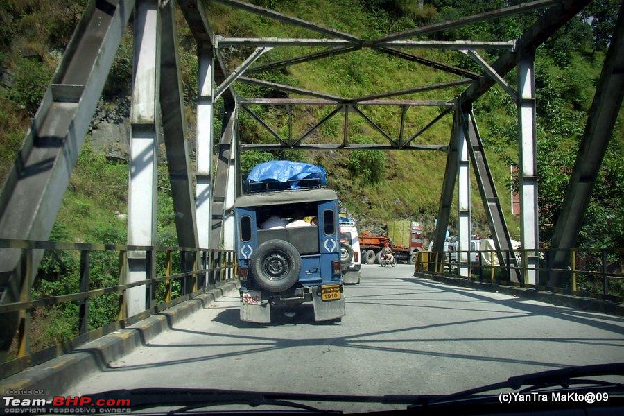 Saw this close to Assam Oil Petrol Pump at Suntaley, could never spot it in any of my visits to Sikkim.  After about 27 kms from Coronation Bridge, we come to the bridge at Teesta Bazaar. Here we cross over the Teesta again, back on to the eastern side. Also, from here an interesting scenic road bifurcates for Darjeeling. The road for Darjeeling, against intution, bifurcates down to right towards the river and then crosses below the NH 31A just before the bridge, before beginning its rapid climb up to Darjeeling. So at the bifurcation, we take left or the relatively uphill road, continue as the road turns a sharp right to cross over the bridge and then turns sharp left to continue hugging the Teesta. Google Map of Teesta Bazaar 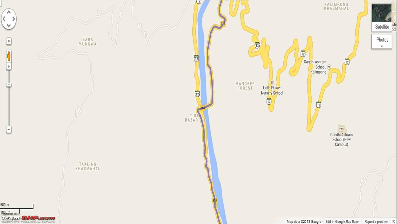 Here is a picture of the bridge, from one of our earlier trips. Bridge at Teesta Bazaar 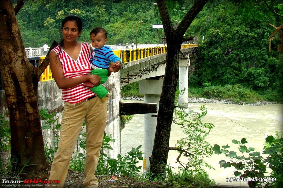 About a km or so further up, the road for Kalimpong cuts away to the right and starts its rapid ascent. About another km and a half from or about 30 odd kms from Coronation Bridge, we come to the junction of Teesta and Rangit Rivers. Teesta was flowing in Bengal till now, but from now on till some further distance up stream it forms the boundary between Sikkim and West Bengal. Also from this junction till some part upstream Rangit too forms the boundary between the two states. So, though we are not yet in Sikkim, but it is just across the river. In fact, this junction is the southern most point of Sikkim. Teesta Rangit Junction 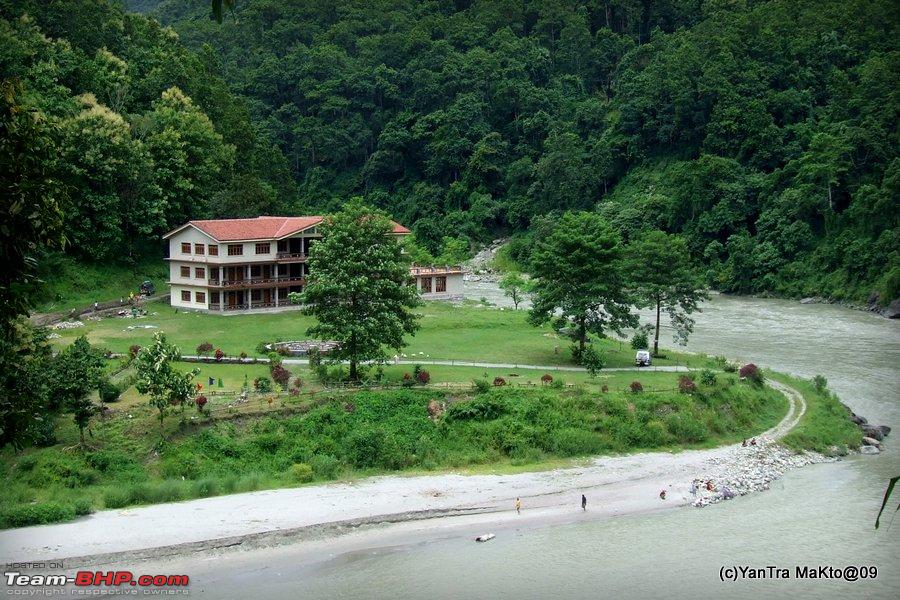 Rangit is the river behind the building flowing left to right in the picture. It joins Teesta which is flowing right to left in the picture and in front of the building. Just a stray thought considering what happened in Kedarnath recently. God save those who live here during monsoons. But it is a temptingly beautiful location none the less. Around 2 and 1/2 kms further up or about 33 kms from Coronation Bridge, we come across the comparatively shabby settlement called Melli Bazaar. Here the NH 31A passes below a bridge which crosses Teesta. On the other side of Teesta starts Sikkim with the town of Melli. This can be considered as the Gateway to South and West Sikkim. To go over the Bridge and into Sikkim, we have cross under the bridge and after about 100 mtrs turn a sharp right (almost like a U turn) to take the entry ramp of bridge. More about those parts of Sikkim some time later. Between Melli Bazaar and Teesta Bazaar, we can find many White Water Rafting Centres catering for all types of rafters. One of the better located one. 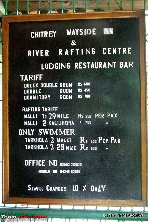 About 18 kms from Melli Bazaar or about 51 kms from Coronation Bridge, we finally enter Sikkim through the border town of Rangpo. Rangpo town is situated at the confluence of Rangpo Chu i.e Rangpo river with Teesta. Google Map of Rangpo Town  The river coming from right is Rangpo chu joining Teesta. Just before entering Rangpo we cross the Rangpo Chu and then crossing the bridge finally enter Sikkim after running parallel to it for about 21 km. It has a nice gate welcoming us to Sikkim and standard police and octroi post etc. The town has all the ingredients of a border settlement with lots of transport agencies, liqour shops, petrol pumps etc. As petrol and liquor is cheaper in Sikkim than the neighbouring state of West Bengal. The road condition improves on entering Sikkim. In Rangpo, one has to take a sharp left to continue onto NH 31 A. After crossing the first setllement of Rangpo, the road again hugs along the eastern bank of Teesta River. Then comes the second set of settlement of Rangpo where there was mouth watering aroma of Wai Wai instant noodles spread all around in the hill. Wai Wai is a brand of instant noodles which is popular in these parts of the country and is my personal favourite too compared to any other instant noodles. Yum. Since we had not really eaten much except for the packed breakfast, we could not stop ourselves from getting pulled towards the origin of the wafting delicious smell. The Wai Wai Factory near Rangpo 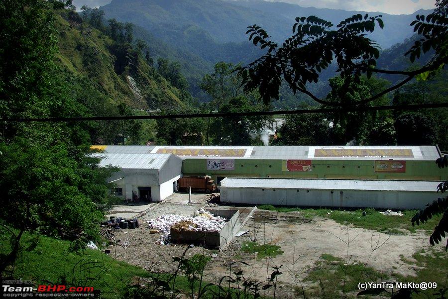 Outside the Wai Wai Factory 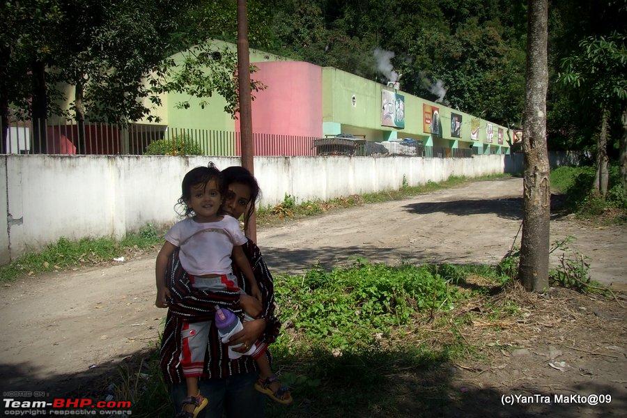 We tried to have a look at the factory but it was closed for lunch. None the less picked up some Wai Wai packets from a company outlet nearby. Sikkim in these parts is pretty industrialised for a mountain state, even compared to industry less neighbouring North Bengal. There are a lot of Pharmaceutical manufacturing units and few distilleries till Majitar. Also just before Majitar is the famous Sikkim Manipal Institute of Technology A view of Sikkim Manipal Institue of technology on the banks of Teesta 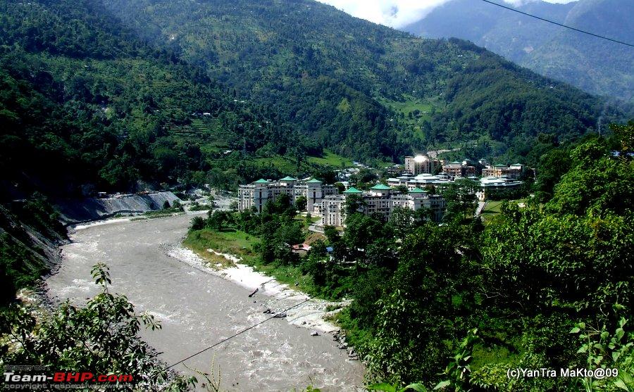 A close up of SMIT 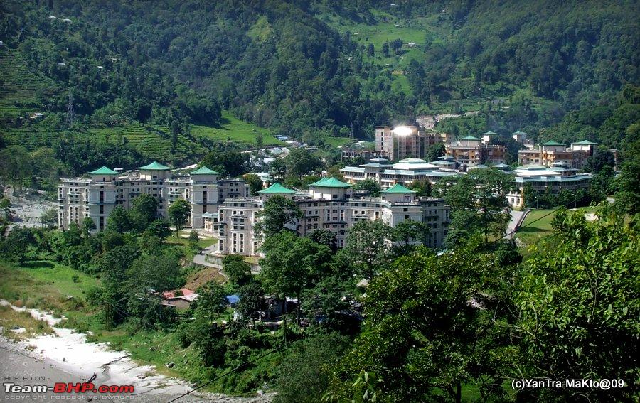 About 62 kms from Coronation Bridge, we come across the town of Singtam. Google map of Singtam.  The Ranikhola river meets Teesta at Singtam. At Singtam, the NH 31 A finally leaves the company of Teesta and now is along the Ranikhola river which we have just crossed at Singtam. Till now we have hardly gained any altitude since the beginning of our journey. It is only now that we start climbing the remaining 1400 mtrs or so till Gangtok. About 78 kms from Coronation Bridge is the town of Ranipool, most probably named after the bridge over the Ranikhola river. The Roro Chu joins the Ranikhola close to Ranipool. Gangtok lies on the ridge between these two streams of Ranikhola and Roro chu. Terraced fields near Ranipul  Soon we reached Gangtok, and it seemed beautiful, clean and well laid out. We reached our accommodation and relaxed for some time. Soon, we were out again for obtaining permits for Nathula. We had to hurry up, as though I had planned for 3 days in Gangtok, with the 2nd day in Gangtok slated for Nathula; but reaching Gangtok we learnt that Nathula is closed for tourist on Mondays and Tuesdays. So the only day available to us for visiting Nathula was tomorrow i.e Sunday and thus we had to get our permits done today itself. We already were carrying copies of our passport size photos and photocopies of identity proofs etc. Thus we did not have much problem in getting the permits. As we still had enough time available today, we decided to visit few of the places in Gangtok. Being interested in Tibet etc, the first place which we visited was the Namgyal Institute of Tibetology. Also, we decided to visit it first as it closes the earliest at 4:00 PM. The institute was established in 1958, inaugrated by Pt JL Nehru and the foundation stone was laid down by the Dalai Lama. It contains one of the world’s largest collections of Buddhist books and manuscripts, plus statuettes, thangkas (Tibetan cloth paintings) and sacred objects. Namgyal Institute of Tibetology, Gangtok 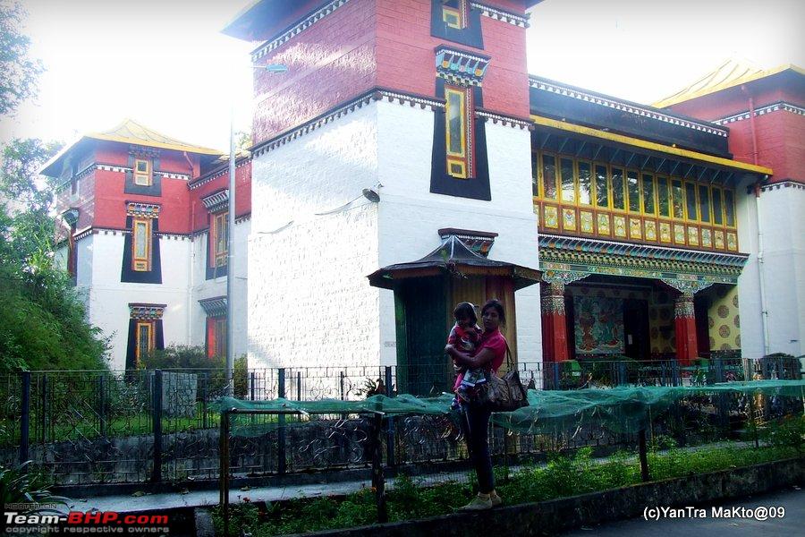 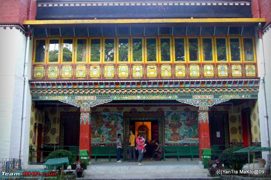 The museum building seen above contains for public view unique things such as a kapali (sacred bowl made from a human skull) and human thigh bone trumpets. The Institute itself is located in beautiful wooded surroundings and bang on the ridge line above Gangtok.  We had just about made it in time to visit the Museum of the Institute. Just opposite to the Institute there was a beautifully located small eating joint. It had standard plastic tables with chairs to sit. The menu displayed looked good enough. But on entering it we found that most of the items were not available as it was close to closing time. But the view of the forested slopes from the sitting out area of the joint was good, and we thus decided to have something to eat and ordered Momos and Coffee. While me and son hungrily waited for the order to materialize, wife went surveying the interesting and cute little curio shop close by. Do not get the impression that there were many shops / shacks there. These were the only two establishments there. Since the Institute was located on the road to Duddul Chorten, we decided to might as well visit it next. The car has to stop short at the parking spot. And then we have to make a short climb to reach the Chorten. Note: Quote:
Quote:
Once you reach there, it is good, especially with the Chorten appearing beautiful in the light of the evening sun. The Duddul Chorten. 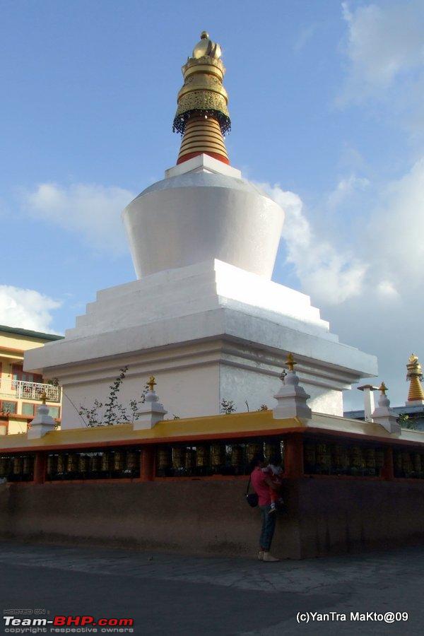 Wife and son spinning the prayer wheelsYou are supposed to make circumvent the temples clockwise, while rotating these prayer wheels clockwise too. The hand held prayer wheels which the Buddhist carry while rotating them contain prayers written a specific times (maybe 100, 1000 or so on, depending on the size) inside them on long scroll. Thus rotating it once is supposed to endow you with the benefits of saying the prayer those many times! Casting a Web to catch the spirits...  Its getting cold with the setting sun, winters have come.  Video of Lamas praying at Lhakkhang at Duddul chorten Next we went to the Ridge Park. We just walked down the park enjoying the environs and the colourful flowers, while kiddo enjoyed chasing around the pigeons there. At the end of Ridge Park is the Flower Exhibition Hall. Here we can find many varieties of Orchids and other flowers most of the year. At the Flower Exhibition Hall, Ridge Park, Gangtok  Then, we went for some rest back to our stay. Before coming out again, we put on a layer of warm clothing as it had started getting pretty cold in the night as opposed to the comfortable and at times rather hot temperatures of the day. We went 'Malling' to MG Road of Gangtok, which can be considered as the heart of Gangtok. Vehicular traffic is not allowed on the road during earthly hours. Why I say this is because I saw a few bikes zipping past in the late night hours, whether allowed or breaking rules, am not sure. The road has a nice touristy festive atmosphere to it, with your normal tourist oriented hill station shops and curio stores. Though you will find some daily usage grocery store type of shops also. We bought a pair of woollen gloves and a woollen cap for the young one. And also bought a pair of ear muffins for each one of us. After some exploration around, we found a value for money restaurant in of the stepped by lanes of the road. It was named the 'Hot Spot', it had only 4 to 5 four seater tables. It appeared comfy and cozy, with the prices being reasonable and not tourist hyped. We tried out the dinner here for the first night, found it good and were back here almost all days after a few bad trials at other places. Sad to say, but I found the place with name, owner, workers and décor changed in another visit to Gangtok after a few months. Our favourite restaurant during this trip, Hot Spot 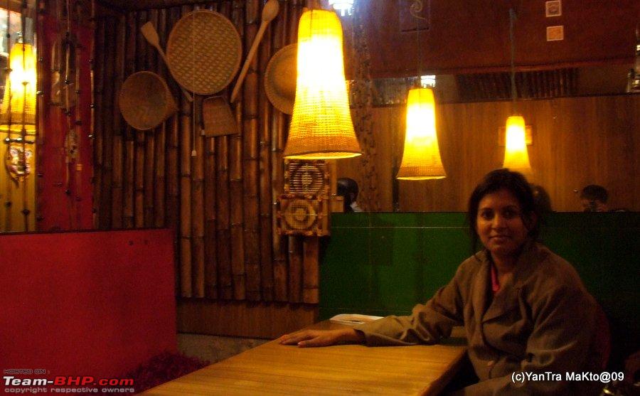 After dinner stroll at MG Road 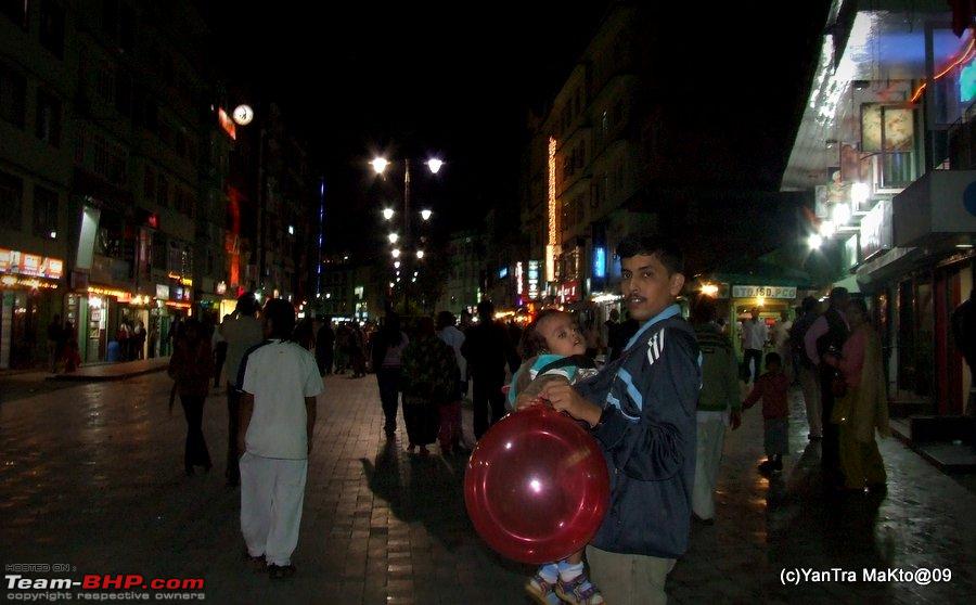 We reached back to our stay early, as tomorrow was the day for Nathula and we had been advised to start early... Coming up Day 2: Trip to Nathula and more.. contd... Last edited by YanTra Makto : 22nd October 2013 at 00:04. Reason: Under construction | |||
|
| (8)
Thanks
|
| The following 8 BHPians Thank YanTra Makto for this useful post: | Ddrive, Gansan, GTO, khoj, Rehaan, rkbharat, rulerofsun, swsumit |
|
22nd October 2013, 09:36
| #3 |
| Team-BHP Support  Join Date: Dec 2004 Location: MH-12
Posts: 8,443
Thanked: 13,956 Times
| Re: Alto'ed: Old Silk Route, along the footsteps of great explorers into Little Tibet Thread moved from the Assembly Line (The "Assembly Line" Forum section) (http://www.team-bhp.com/forum/announ...m-section.html) to Travelogues. Thanks for sharing! Last edited by moralfibre : 22nd October 2013 at 09:37. |
|
| ()
Thanks
|
|
22nd October 2013, 21:32
| #4 |
| BHPian Join Date: Jun 2013 Location: Chennai
Posts: 254
Thanked: 534 Times
| Re: Alto'ed: Old Silk Route, along the footsteps of great explorers into Little Tibet Nice places, nice pictures !! And a family tour is one which always rocks  |
|
| (1)
Thanks
|
| The following BHPian Thanks Ddrive for this useful post: | YanTra Makto |
|
23rd October 2013, 18:06
| #5 | |
| BHPian Join Date: May 2013 Location: India
Posts: 143
Thanked: 465 Times
| Re: Alto'ed: Old Silk Route, along the footsteps of great explorers into Little Tibet Quote:
 Better ones coming up still, hope you like them | |
|
| (1)
Thanks
|

| The following BHPian Thanks YanTra Makto for this useful post: | Ddrive |
|
24th October 2013, 20:59
| #6 |
| Senior - BHPian | Re: Alto'ed: Old Silk Route, along the footsteps of great explorers into Little Tibet Sikkim is one place I visited way back in the mid-nineties. While we see a lot many travelogues on Leh, Sikkim is much less covered in t-bhp - adc's Sikkim travelogues was an outstanding one. I must admire your courage to take such a young child alongwith you, in altitudes in excess of 5000 m. What brand electric kettle do you use ? I have a 800watt Morphy Richards for my kids but I can't use it in the car as it will blow the lighter fuse. I've got a M800 in Kolkata, and seeing your pics , I might just visit Sikkim in it someday ! Last edited by sdp1975 : 24th October 2013 at 21:00. |
|
| (1)
Thanks
|
| The following BHPian Thanks sdp1975 for this useful post: | YanTra Makto |
|
24th October 2013, 21:11
| #7 | |
| BHPian Join Date: May 2013 Location: India
Posts: 143
Thanked: 465 Times
| Re: Alto'ed: Old Silk Route, along the footsteps of great explorers into Little Tibet Quote:
Wow, humbling to know that the pics could inspire you. You must make a go for it ! | |
|
| ()
Thanks
|
|
25th October 2013, 13:10
| #8 |
| Senior - BHPian Join Date: Oct 2013 Location: B'Lore :)
Posts: 1,233
Thanked: 1,240 Times
| Re: Alto'ed: Old Silk Route, along the footsteps of great explorers into Little Tibet Indeed, Sikkim is one of the lesser known states. But it offers a huge potential for tourism. The state seems to be worth exploring. However, I wonder why most of the North - East states do not attract tourists. After all, they have more natural beauty and splendour than most of the mainstream states.  : : |
|
| (1)
Thanks
|
| The following BHPian Thanks FINTAIL for this useful post: | YanTra Makto |
|
25th October 2013, 23:37
| #9 | |||
| BHPian Join Date: May 2013 Location: India
Posts: 143
Thanked: 465 Times
| Re: Alto'ed: Old Silk Route, along the footsteps of great explorers into Little Tibet Alto'ed: Old Silk Route, along the footsteps of great explorers into Little Tibet. Day 2, Part I. So let us start with the Fun Part. Day 2, Sunday Route: Gangtok - Sherathang Mart - Nathu La - Baba Memorial - Kupup - Baba Mandir - Water shed Memorial - Tshomgmo Lake - Kyongsala Falls - Gangtok. Distance Covered: ~ 142 kms Maximum Altitude: 4310 mtrs Minimum Altitude: 1700 mtrs We had decided that we will set course early for this days trip, as had been advised to us. Nothing like tucking in to a warm fluffy quilt on a chilly night. So after having a good nights cosy sleep in the chill of Gangtok, we forced ourselves up early in the morning. It literally took quite an amount of will power to leave the comfort of warm bed and quilt and force myself into the daily routine. Once I was done, I started with the morning ritual of checking up the tyres, pressures, engine oil, coolant, brake liquid etc. Filling up the wind screen water sprayers reservoir was an important task given the conditions of the roads while wife readied up herself followed by the kid. While she packed the days stuff, I took a stroll around the road with the kid and got some tea. Strolling around with the still asleep kid.  I then packed the car, nothing much and pretty light, mostly eatables, and the tent, sleeping bag, emergency light, cooker etc for unseen situations. Thus majorily the clothing was left behind and it was quite a major part of our luggage. We did manage to start by 0730 or so, quite an achievement with a kid. Hats off to wifey. The route to Nathula from Zero Mile Gangtok 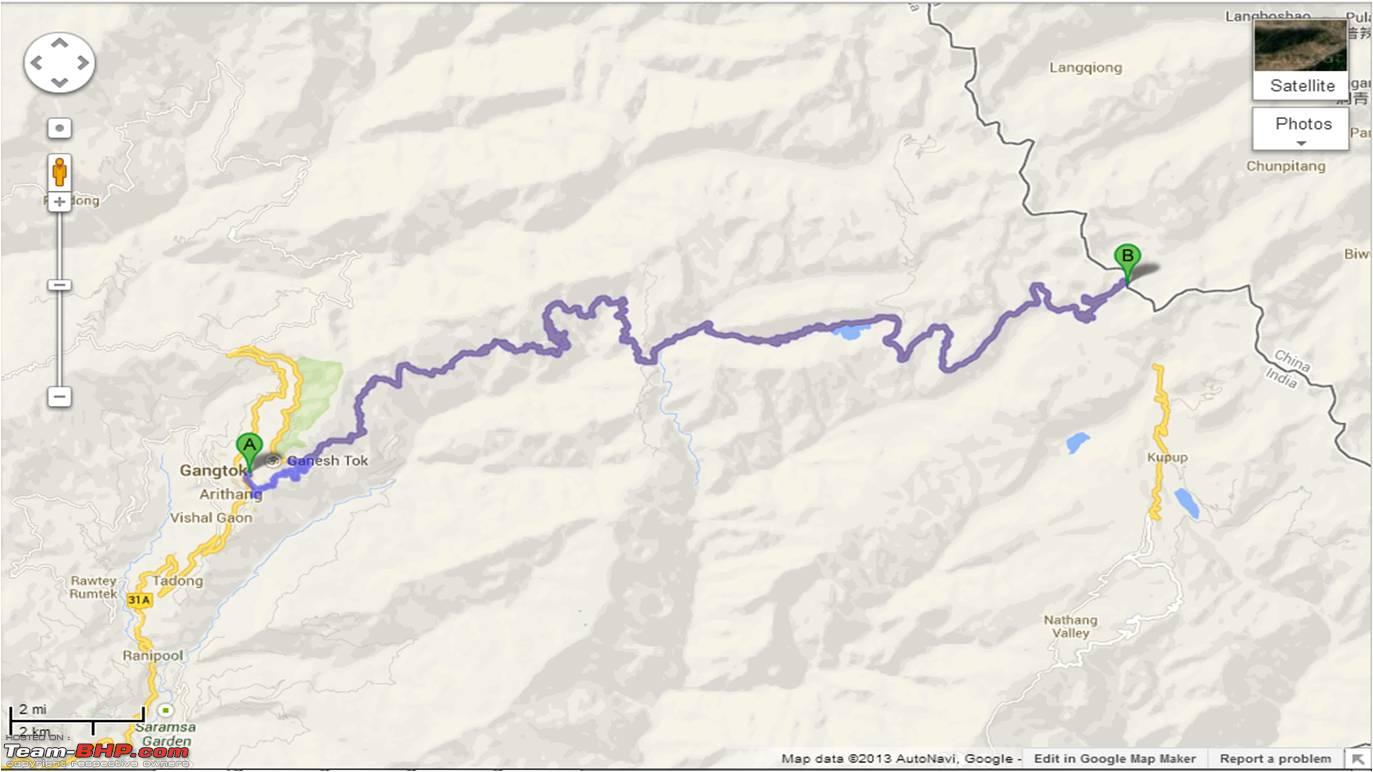 But as stated in earlier posts, we did not had any GPS / navigational facility, and traversing this 4 km section of JN road / Chandmari road was slightly confusing in the early morning with not much people to ask around. Slightly confusing section during the start. 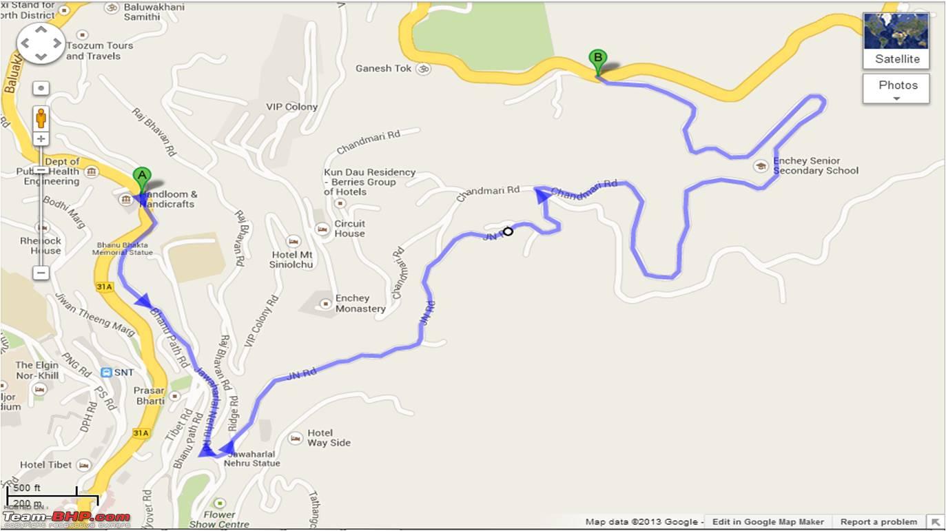 Once we hit the road to Nathula, it was easy as it was the only main road, with no scope of confusion. Just after a km or so on this road, we reached the check post at 5th Mile. Our permits were checked here and we entered the vehicle and our particulars in a register. We were the 4th non army vehicle at the check post for the day. Beside the check post was also a tourist information centre. The early morning drive was very refreshing and scenic with beautiful vistas, with bright sunshine alternating with mild gloom of shadowy slopes and light mist of low clouds playing hide and seek with us and the slopes. Time for some pictures now ! Village huts and Army Barracks on way to Nathula in idyllic settings.  On way to Nathula, green slopes interspersed with conifers and rhododendrons  Horses on the way, these and the mules would have been the only way to travel these routes till few decades back!  Clouds playing hide and seek.  Finally the sun breaks through on our road ahead!  About 25 Kms from Zero Mile, Gangtok we cross over the Kyongsa La. This ridge line forms the water shed between the Roro Chu stream (which meets Ranikhola at Ranipul) and one of the main streams of Rangpo Chu. Just before crossing the ridge, we crossed a particularly bad section of road in a landslide prone zone. Though the Alto crossed over the obstacle easily with some careful driving. Difficult patch on road to Nathula, just before Kyongsa La. 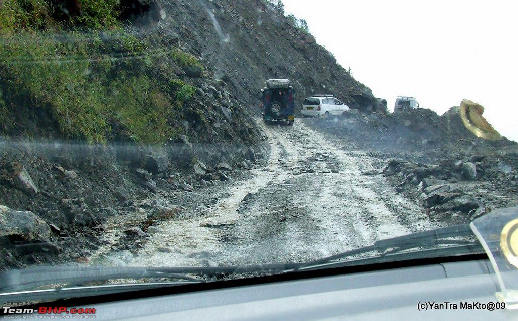 Video of negotiating the patch at Kyongsa La. After crossing the Kyongsa La, the road has a gradual climb, almost level by Himalayan standards, as it runs parallel to a major tributary of Rangpo chu. Just another pic.  Almost level road running parallel to stream offering nice views of the slopes on other side  Somehow, maybe due to the road and dust, or orientation of the ridge with respect to sun, the ridge on the other side was beautiful as compared to the slightly barren on our side. We were enjoying the drive, the pace was slow due to various stoppages for photography and just to general enjoy the moment, the scenery and the atmosphere. While we had stopped for one such enjoyable admiration, we saw some camouflaged movement on the opposite slope. Yes they were Yaks ! Once we saw one, we knew they were there and shortly we spotted many more of them, grazing away to their hearts content on the beautifully forested slopes on opposite side. Yaks grazing to their hearts content. 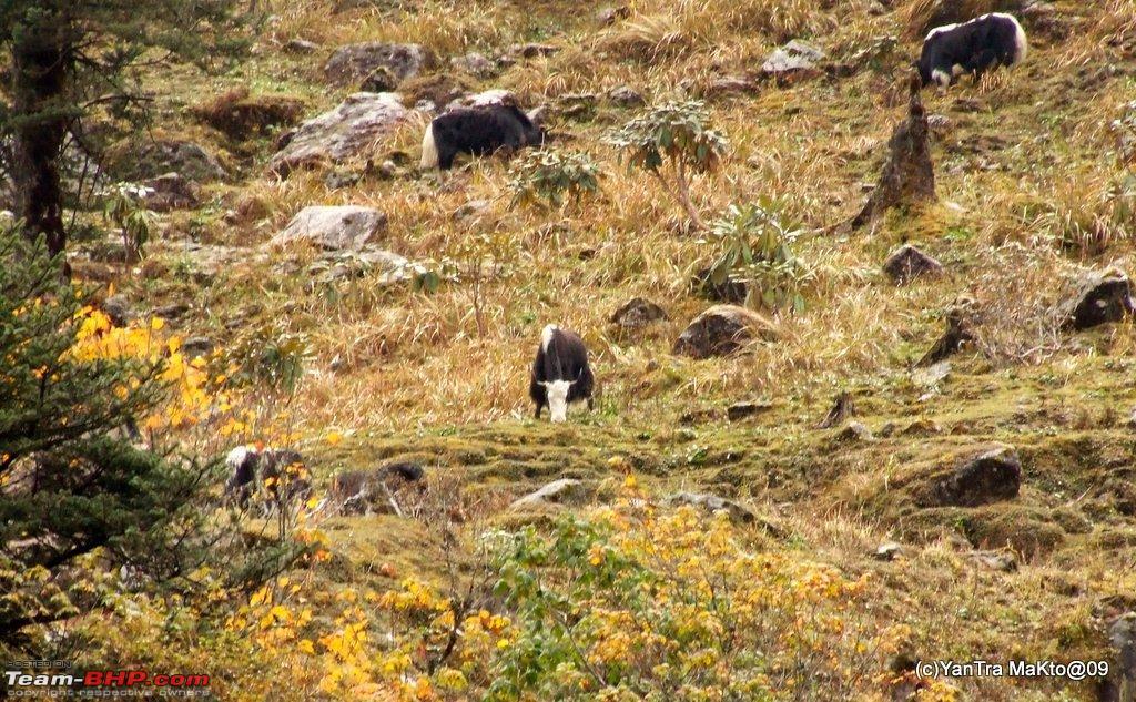 We continued enjoying the drive.  About 34 kms from Zero Mile, Gangtok a surprise awaited us. It was the sudden appearance of the beautiful Tshomgo Lake. The view of the lake opens out suddenly as you climb a left bend in the road. This video shows what I am trying to say in words. Approaching the Tshomgo Lake. It was one of the most beautiful sights I had seen till then. (I did not know then that within a couple of days I will be witnessing scenes which will be better.) At the Tshomgo Lake.  A bit about Tshomgo / Tsomgo Lake. Also called as the Changu lake to ease out the tongue twister on tourist tongues. Its 'USP' as per Sikkim Tourism Development Corporation's website. Quote:
Detailed info on the Sikkim Tourism Development Corporation. Quote:
As per Official Website of Sikkim Tourism. Quote:
And for those who are more interested, please follow this link http://www.sikkimeccl.gov.in/History...HolyLakes.aspx While we were parked on the shores of the lake, my son who seems to have a photographic eye, insisted on taking a pic of these, I took it to satisfy him and it did look good. Rocky Outcrops on shore of Tsomgpo Lake, taken on son's insistence! 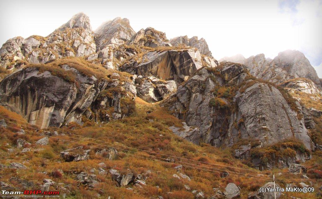 There was a small touristy complex just before the small climb up to Tshomgo. But we had not stopped there, as it was not yet fully up and running, and as we wanted to stop at Sherathang, as we had heard that there was market there of Chinese stuff. Also, as we will be travelling on the some road, we decided that we will stop here while on the way back. And as it is, the aim right now was Nathula and to Nathula we kept going. One more view of the Tsomgo Lake. 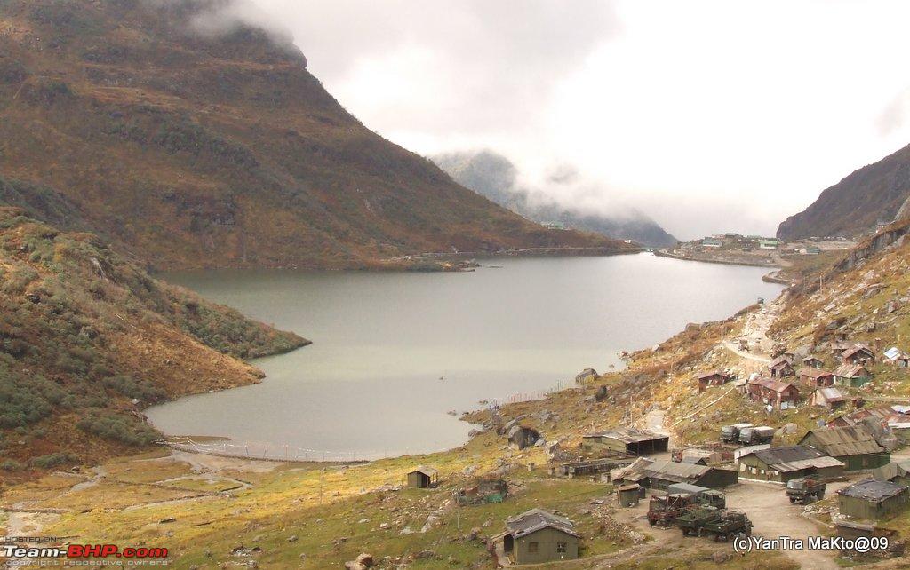 to be contd... | |||
|
| ()
Thanks
|
|
26th October 2013, 00:43
| #10 |
| BHPian | Re: Alto'ed: Old Silk Route, along the footsteps of great explorers into Little Tibet Dear YanTra Makto, I am surprised that you could reach Tsongmo lake with your car. I left my car (a sedan) at Gangtok and took a trip in a hired vehicle, when I visited it this year in May. The furthest point I drove to on that road was only up to Hanuman Tok. Although I was not sure where and how I could get the permit for my car, I was also told that the roads were in very bad shape. And I did not regret my decision, as I saw that the roads were really bad. Really a commendable performance. I am really surprised the way you managed the ground clearance with your car, travelling all the way up to Gurudongmer lake.  |

| (1)
Thanks
|
| The following BHPian Thanks rahul4640 for this useful post: | YanTra Makto |
|
28th October 2013, 11:42
| #11 |
| BHPian Join Date: May 2008 Location: Mumbai
Posts: 318
Thanked: 208 Times
| Re: Alto'ed: Old Silk Route, along the footsteps of great explorers into Little Tibet [COLOR=black]Lovely articulation. Loving every moment of it.And hats off the lady for managing your kid so efficiently. Coming back to some serious questioning. From where did you get the permits from. If you can please put in the details please. Yes I am talking about the old silk route permits along with Nathula. [/COLOR] |
|
| (2)
Thanks
|
| The following 2 BHPians Thank me_sid for this useful post: | swsumit, YanTra Makto |
| |
|
28th October 2013, 12:22
| #12 |
| BHPian | Re: Alto'ed: Old Silk Route, along the footsteps of great explorers into Little Tibet Yantra Makto, It is indeed a commendable achievement to reach the upper reaches of North Sikkim (Gurudongmar and Yumthang) in an Alto. I am sure, all of us would love to hear from you how you navigated the steep hair pins and treacherous roads in your car.  - A little ignorance on my part, but what does "YanTra Makto" mean? - A little ignorance on my part, but what does "YanTra Makto" mean? |
|
| ()
Thanks
|
|
28th October 2013, 18:10
| #13 | |
| BHPian Join Date: May 2013 Location: India
Posts: 143
Thanked: 465 Times
| Re: Alto'ed: Old Silk Route, along the footsteps of great explorers into Little Tibet Quote:
Yes I did get stuck twice, once recovered with help of few shoves and pushes and once in third attempt. And there were about eh lemme remember..., four more occasions when I was wary cause of certain bad patches of road condition. Out of these two I got away without trouble and just about made through on two more. Details will follow in further posts. But overall guess was lucky too and as it is we had started with the understanding that we will try to reach a certain place but it does not matter if we do not reach it as aim was to drive and enjoy!! | |
|
| (1)
Thanks
|
| The following BHPian Thanks YanTra Makto for this useful post: | swsumit |
|
29th October 2013, 22:35
| #14 | |||
| BHPian Join Date: May 2013 Location: India
Posts: 143
Thanked: 465 Times
| Re: Alto'ed: Old Silk Route, along the footsteps of great explorers into Little Tibet Quote:
Quote:
Quote:
 . .Well 'Yantra Makto' is my own little private puzzle. Hint: Its made of two languages, one ancient and other latest and imaginary! | |||
|
| (1)
Thanks
|
| The following BHPian Thanks YanTra Makto for this useful post: | sayakc |
|
29th October 2013, 23:16
| #15 |
| BHPian Join Date: Feb 2010 Location: siliguri/Darj
Posts: 516
Thanked: 329 Times
| Re: Alto'ed: Old Silk Route, along the footsteps of great explorers into Little Tibet Wow great trip and great pictures! can you give us more details about how you were able to get permits for your car to drive to Nathu-LA and Gurudongmar lake? Are you some how connected with the Armed forces? Hats off for pulling it off! |
|
| ()
Thanks
|
|