| |||||||

| Search Forums |
| Advanced Search |
| Go to Page... |
 |
| Search this Thread |  41,919 views |
 14th June 2017, 16:51
| #1 |
| BHPian | Ladakh'ed in a Tata Safari Storme Before I get started, I must put a word of thanks for Tanveer a.k.a. tsk1979 without whose writeup of the region, this trip would not have been possible. So thank you sire! Almost anyone I know has a wistful look when Ladakh is mentioned. Though most seem to know it as "Leh". Everyone wants to go there. Few want to drive around after reaching Leh. And fewer still want to drive to Leh. I belong to the last category. And for me it was not just Leh, but Ladakh. I wanted to see as much of the whole district that I could. This year I could finally make it there and so here is my story of Ladakh. For those who are reading this, here is what you can expect from this thread: 1. A drivers account of the journey. But this will be best exploited when you read it in conjunction to the thread by tsk1979. 2. Tips on accommodation, food and most importantly fuel. 3. Some details about the sights and places to see along the way. 4. Tips to plan and execute the travel better than I could! My journey started form Gwalior, so the broad travel plan was as follows: 21 May 17: Gwalior - Agra- this was basically a get out of Gwalior phase! 22 May 17: Gwalior - Chandigarh 23 May 17: Gwalior - Udhampur 24 May 17: Udhampur - Awantipora 25 May 17: Awantipora - Kargil 26 May 17: Kargil - Rangdum via Pesi la 27 May 17: Rangdum - Kargil 28 May 17: Kargil - Leh 29 May 17: At Leh 30 May 17: Leh - Thoise 31 May 17: Thoise - Turtuk - Thoise 01 Jun 17: Thoise - Siachin Base Camp - Thoise 02 Jun 17: Thoise - Agham - Shyok - Pengong Tso 03 Jun 17: Pengong Tso - Chusul - Loma - Hanle -Loma - Nyoma 04 Jun 17: Nyoma - Tso Morr i- Tso Kar - Durbuk - Sarchu 05 Jun 17: Sarchu - Manali 06 Jun 17: Manali - Ambala 07 Jun 17: Ambala - Gwalior Every one seems to be posting "teaser pics" on their threads. And looking at the amount of typing that has gone in till now, I can understand why! So here are a few pics to pique you interest and to give you a glimpse of what lies ahead!!  Scenic quaint village  Roads??   Beautiful vallies  Isolated Monasteries  Stunning sunsets! Last edited by neel385 : 26th June 2017 at 15:13. |

|  (20)
Thanks (20)
Thanks
 |
| The following 20 BHPians Thank neel385 for this useful post: | (Alok), Akib Khan, AlphaKilo, aniket17, dailydriver, darklord, FORTified, GTO, jaunthead, Nohonking, NPV, Prowler, Rohan24, Samba, sdp1975, supertinu, The Brutailer, TOINGPOING, YanTra Makto, YDS |
| |
|
14th June 2017, 18:26
| #2 |
| BHPian | Re: L.A.D.A.K.H.E.D. at Last!! Since Ladakh is the centrepiece of this thread, I'll restrict my posts basically to that region. However, a word of getting into Ladakh is necessary at this stage. The plan followed by me is as given above. However, there are a few pointers that I would like to suggest to fellow travellers: 1. Entry to Kashmir will not be without hassles as far as the road conditions and traffic are concerned. 2. In order to bypass Jammu, consider taking the Samba-Mansar-Udhampur road which is presently in decent/good condition. 3. Post Ramban, traffic can be horribly slow till the Jawahar Tunnel. I took about 2.5 hrs to cross this stretch. 4. Post the Jawahar Tunnel, traffic and roads will be much better till you cross Srinagar. 5. Entry to Sonmarg will take time due to Toll collection by the locals. 6. For the entry from Srinagar, I would suggest that Sonmarg should be planned as the last stop before crossing the Zozi La. There are various reasons for this: (a) Sonmarg itself is beautiful. It would be worthwhile to spend a night here. (b) There are numerous hotels very close to the check point with decent facilities which will allow a quick start the next morning. (c) Starting the climb for Zozi La in the morning from Sonmarg will ensure that you do not get caught in the horrible jams close to the pass at Baltal due to tourist vehicles. I lost about an hour in jams there. Hence plan in such a way that you have at least about 2 hrs to spare when you reach your destination. Last edited by neel385 : 16th June 2017 at 16:54. |
|
| (10)
Thanks
|
| The following 10 BHPians Thank neel385 for this useful post: | aniket17, dailydriver, darklord, GTO, jaunthead, Rohan24, Samba, sdp1975, TOINGPOING, Unavowed_X9 |
|
14th June 2017, 19:10
| #3 |
| BHPian | Re: L.A.D.A.K.H.E.D. at Last!! Part I : Reaching Kargil  The route followed I set off from Awantipora at about 0830 hrs. The roads till Srinagar were in good condition except or the four lane work that was in progress and therefore reached Srinagar in about an hours time. After Srinagar, the road narrows down and therefore the average travel time does take a big hit. However, the environs are beautiful and therefore one does not really mind. As you continue, the road positions itself along the Sind river which is initially on your right and which you cross over approaching Durpora. Expect to loose some time as the bridge is one way only and therefore crossings take time. Thereafter the road winds along the Sind till you reach Sonmarg.  Along the Sind Along the way, you will be seeing the first views of the Himalayas that you will conquer in the following hours.  First view of the Ranges Thereafter, as you cross Sonmarg and the crazy jams at Baltal, the climb for Zozi La will start. The commencement of the climb will be rather conspicuous since the roads will end and a basic track will take its place.  Roads on the way to Zozi La  As I was crossing in the end of May, snow was abundant. In fact the road had been opened just about a week back.  Ice meant snow walls along the way!  Along the way to Zozi La and beyond!  Along the way to Zozi La and beyond!  Along the way to Zozi La and beyond!  Along the way to Zozi La and beyond!  Along the way to Zozi La and beyond! As the pictures show, the road conditions do not offer for fast travel. In case bad weather is in store for you as it was for me, speeds will be even slower.  Driving in the rain/snow at Zozi La However, as in all dangerous situations, traffic is fairly disciplined as far as the locals are concerned. Lanes are generally followed and so traffic is smooth. And so it goes, chugging along merrily, finally feeling one with the great mountains till you descend down to the plains of Drass. It will be green after quite a while and so, enjoy the views.  First view of the Drass valley  In Drass town Just after crossing the town, you will come to the Kargil war Memorial.  The Kargil War Memorial Seeing the names of people you have known as friends on a wall was an emotional moment for me. The memorial is a good place to go and try to get a feel of what some of us do to allow the others to take their freedom for granted. As you enter the memorial, I would urge all to first proceed to the Hut Of Remembrance to read about the entire war and it's key players. Having understood the reason behind the memorial, then come out and take a look around the memorial. Do take a look behind the memorial to get an idea of the conditions under which the War was fought. Ask the army personnel to point out the exact peaks and heights. For most, it will be a rewarding experience. Thereon, it is drive with good roads along the Drass Valley. You will know that you are close when you find a river coming up to your right. This will be the Shingo river which will take you to Kargil. 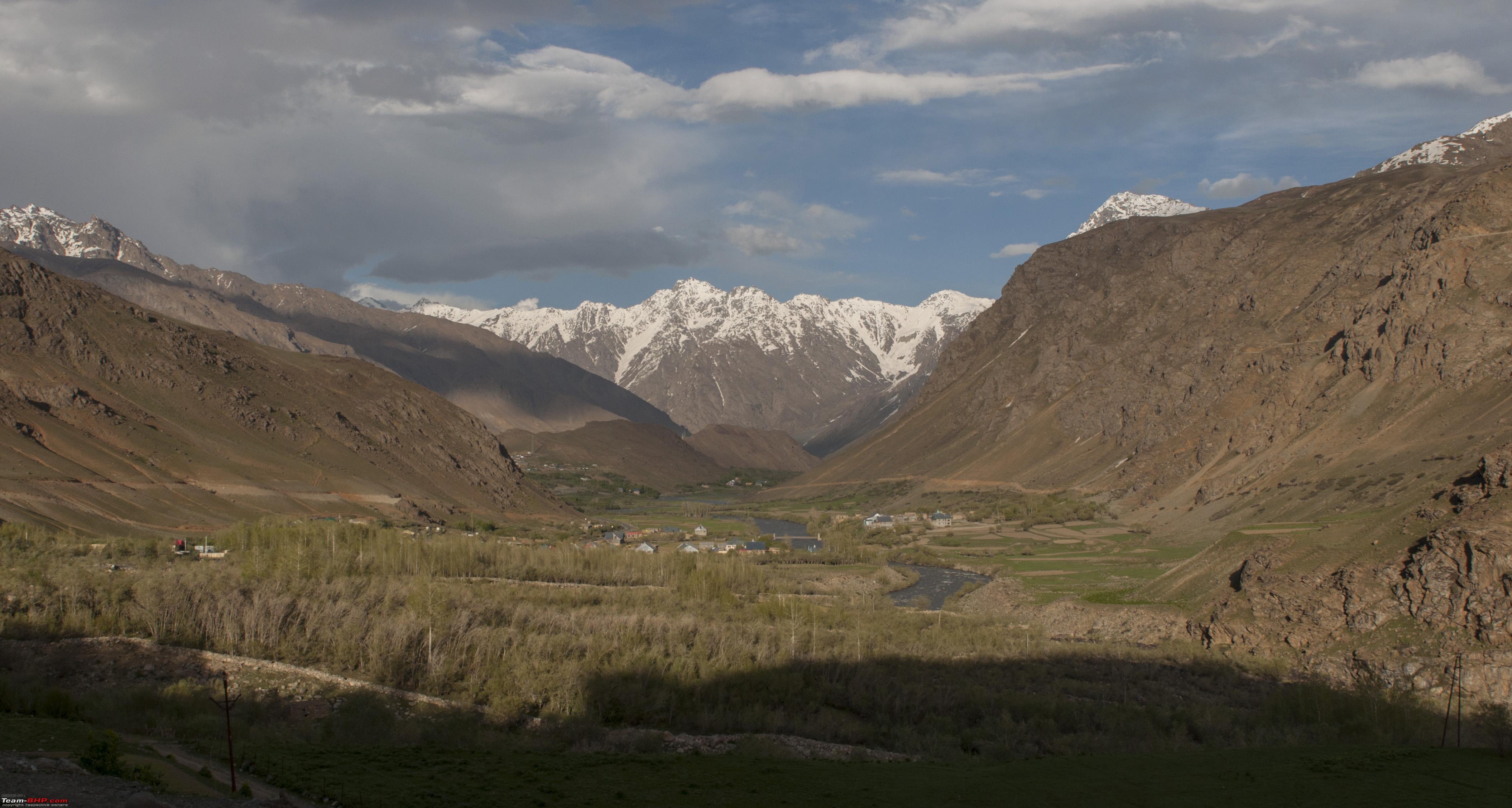 Driving through the Drass Valley  Driving through the Drass Valley  Kargil....at last! I reached Kargil by around 1930 hrs, hence the entire travel time was about 11 hrs. On the way, I spent about 50 min at Sonmarg for lunch and a further 40 min at the Kargil War Memorial. So the total road time was about 9.5 hrs. Last edited by neel385 : 26th June 2017 at 15:14. |
|
| (13)
Thanks
|
| The following 13 BHPians Thank neel385 for this useful post: | (Alok), AlphaKilo, aniket17, bj96, dailydriver, darklord, GTO, jaunthead, mustang_shelby, Samba, sayakc, TOINGPOING, YanTra Makto |
|
16th June 2017, 17:09
| #4 |
| BHPian | Re: L.A.D.A.K.H.E.D. at Last!! Part II : Kargil-Pesi La-Rangdum-Kargil The next day was to be my trip to the Zansar Valley. Unfortunately, for reasons that will subsequently unfold, I would not be able to make it till the Zansar. But boy! What a drive!  The route.. Getting onto the road to Padum was easy as it was well marked. In case of any doubt, remember that you have to take a right before crossing the river en-route Leh from Kargil. As you enter the road which in initially leads to Sankoo, the Suru river joins you on the left to keep you company. The valley floor is beautiful and green and the smooth, tree lined roads make for a wonderful relaxed drive. Do relax as much as you can. There will be little relaxation (but much fun!) later.  Driving along the Suru river  Climb a little higher and the entire valley comes into view  A quaint village on the way Road conditions are good till about 63 km from Kargil. Thereafter, the road becomes patchy. I think that this is a good thing really! It prepares you for what is coming up in a graduated manner! Short of reaching Sankoo, there is a road which will take you to Tai Suru. At this junction, you have a choice to make. Either you can continue straight to Sankoo or turn left for Tai Suru. There are two roads that will lead you to the next major point of Panikhar. One follows the eastern bank of the river Suru and the other the western bank. The eastern bank is relatively free of traffic and it does not pass through any villages. It is therefore faster, but marginally. The western bank road will take you through all the towns and villages and is hence a little slower but albeit more lively. The bifurcation is at Tai Suru. I decided to take the left to Tai Suru. After crossing Tai Suru, look out for a road leading to a bridge crossing the Suru river on your left. Cross the bridge and meet a 'kutccha' road to be on the way! The gradual climb ensues. The roads become slightly narrower and the sights that much more beautiful.  Near Tai Suru...first view of the Nun Kun!  Climbing higher..and getting closer to the Nun Kun! And the village of Panikher  A raging Suru biting through the Snow  And so the roads lead you along the cut in the hill towards Panikhar...  Reaching close to Parakchik, we saw a lovely hill made up entirely of rubble and decided to take a pic! Little did we know what lay in store for us as we went over to the other side of this small hill!  Parakchik Glacier! The glacier is indeed a humbling sight. It just stands there. Big and beastly. But the gentle winds, the sound of the river gushing past give it an air of serenity. But one look at the snout, all dirty with the moraine that it has dragged along its journey explicitly bring out the destructive power that is entombed in the icy mass. I would be lucky enough to feel the power of another glacier, but, that is some way off! This is also the closest that you will get to the mighty Nun and Kun peaks!  The Nun Kun peaks! And this is also the point that all semblance to anything that can be called a "motor able road" disappears! There is a path. And yes, I did see the locals in a Santro in it. But go ahead on a car with low GC at you own peril. That being said, it is not impossible to do it either. One has to be super careful and wary on the road to ensure that your machine is safe from the stones/rocks/water crossings that you will see on the way from now on. But do try and push on. The views will be well worth it.  The path..  The views!  And more views! Leaving Panikhar, the path winds up the mountain side a small way, and then the most beautiful thing happens. The Suru valley starts to open out!  The Suru snakes along the valley moving closer to its place of birth and the open valleys with ther grasslands and cattle being herded by shepherds becomes a lovely sight.  The Suru Valley in all its splendour! 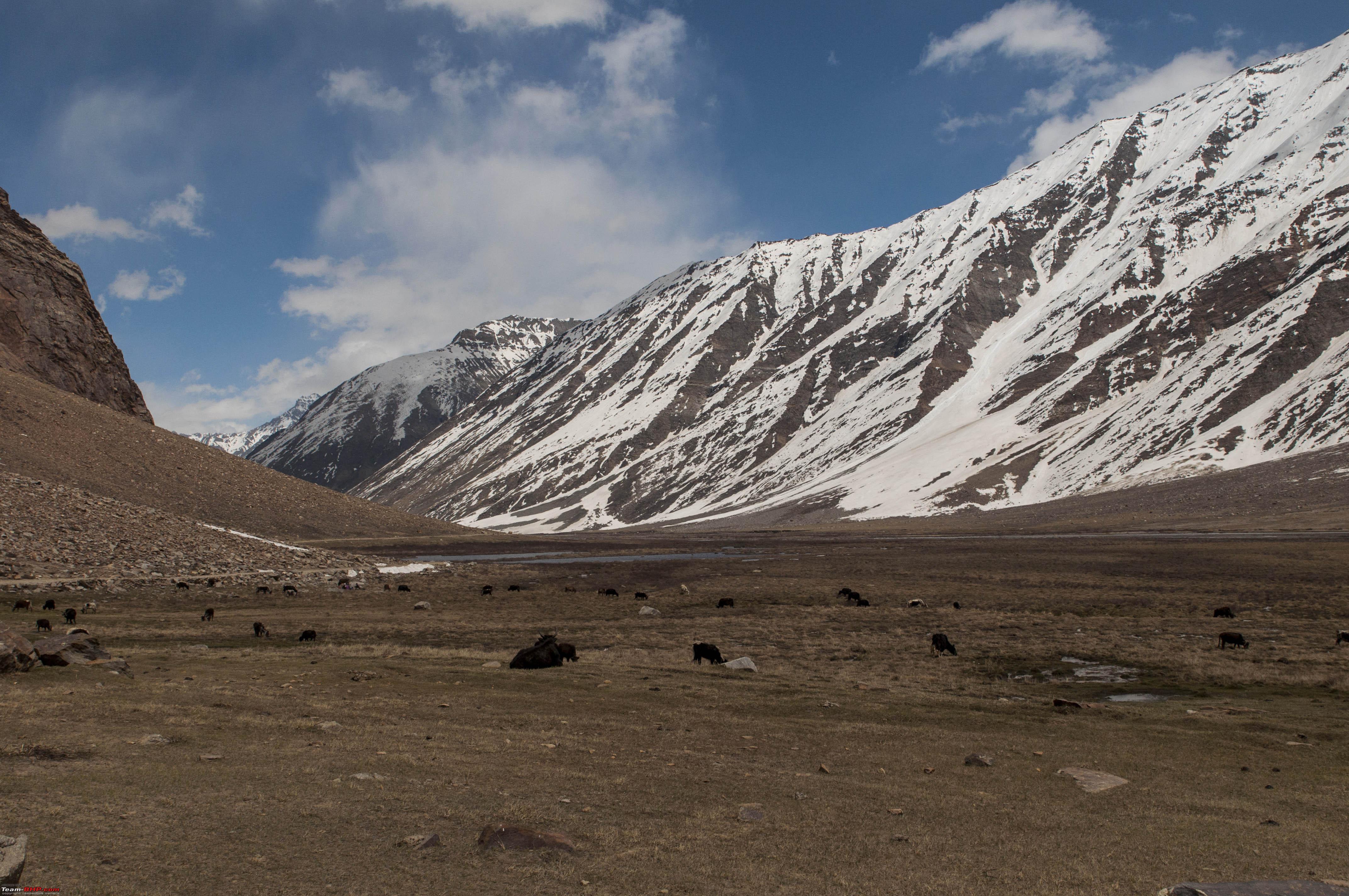 A splendid pasture! With ice all around, it was only a matter of time before we had to give in for the kid's requests for a snow ball fight!  Snowball fight time! And thus continued the road along the cut in the hill, through bends and water crosses till a gradual descent started and we slowly got down to the valley floor and the valley opened out wide before us and Rangdum came to view.  Rangdum village It was already 1500 by the time we made it to Rangdum and we realised that Padum was still about 6 hrs away which meant that after a lunch break of about 45 min, we would reach Padum only by about 2200 hrs. With daylight fading by around 1930 hrs, it also meant that the last three hours or so would be a drive in darkness where we would not really be able to see anything. Secondly, it also meant that the next day we would also have to drive back for at least 10 to 11 hrs to get back to Kargil. Since this was just the beginning of the journey, we quickly decided to drop Padum, go till Pesi La to see the Durung Drang glacier and get back to Ragdum for the night and get back to Kargil the next morning. So after a quick hunting around for accommodation and a lunch of hot Maggi, we set course for Pesi la.  Food and accommodation: Check! The road condition was exactly the same as before, but now, snow and a lot of it, added to the drama.  On the way to Pesi La  A lane cut through the snow! The views were of course as beautiful as ever, and after about a hour and three quarters, we finally got to our destination- The Drung Drang Glacier!  The Drung Drang! As I looked on the other side, the Zansar valley lay beckoning!  The Zansar Valley But well! With the wife and two small kids with me, the safer option had to be the wiser one and with a not so light heart, I turned back and set course for Rangdum. Zansar would have to wait till the next time I got back! The way back was even more dramatic. The sun was setting on the western horizon and this meant that the sky gradually turned golden. And this brought out a totally different facet of the mountains. And it was beautiful. The peaks were suddenly on fire, unearthly shades of colour adorned the mountains, things almost became surreal!  Mountains against the late afternoon sun  Sun, Sand and Snow!  The village of old Rangdum with the peaks on fire!  A study of the shades of brown!  The Rangdum Monastery against the sunset  The glorious evening sky at sunset And it was amongst such views that we got back to Rangdum. Last edited by neel385 : 26th June 2017 at 15:16. |
|
| (8)
Thanks
|
| The following 8 BHPians Thank neel385 for this useful post: | aniket17, bj96, GTO, jaunthead, Samba, sayakc, YanTra Makto, YDS |
|
16th June 2017, 23:01
| #5 |
| BHPian | Re: L.A.D.A.K.H.E.D. at Last!! Back at Rangdum, we settled into the La Himalaya Guest House. There was a JKTDC guest house bang opposite with twin bedrooms for just INR 400, but, what swung the deal was promise of running hot water at INR 1000. Undoubtedly, the rooms were much better as well at this place. I was a bit sceptical about the promise of hot water, but, when I let the tap run for about 10 min, there she was! Steaming hot water on tap! When the temperature outside was 10 degrees! What a joy! After a hearty dinner of Thukpa with sun dried meat and a hot bath afterwards, we retired for the night.  Thukpa with Sun Dried Meat for Dinner! The next morning, the first thing I did as I woke up was rushed outside to see the condition of the vehicle. The thing is, the temperature at 2100 the earlier night was about 10 deg. Naturally, in the night, it would have dropped substantially. And the safari runs on diesel. So being apprehensive was but natural. And what do I see..  Snow kissed...rather hugged Safari! With a lot of apprehensions, I went down, and cranked the engine, and she fired at the first attempt! I let her idle for about 10 min and went back with a smile on my face. So much about starting issues! Woke up the kids, and after a quick breakfast, we set course back to Kargil. The way back was as beautiful as the way here. The valley from the other direction offered different views. And did I mention the Mormots? They were our companions throughout from Panikhar, and this day, in the morning they were out in numbers sunning themselves! Cute little animals they are. But they are not familiar with vehicles and so one has to be careful so as not to run them over.  Beautiful views!  A typical Ladakhi house Notice the roof. The upper layer is of hay or dried grass while below it lies a thick layer of twigs. Seems to serve a dual purpose . Twigs and hay are excellent insulators and they also are the source of fuel for the fire and food for the animals during the winter!  The Mormots!  The last look..  Heading back...villages of Choskor and Panikhar We reached back in about 5.5 hrs since the route was already familiar and we had lesser stops. So as it pans out, Padum will have to wait. Faulty planning really. If I had to plan the trip again, I would not plan a night halt at Kargil initially but move on to the road to Padum. Till Sankoo, almost every village as numerous homestay options and every second village has a JKTDC rest house. So it would be worthwhile to spend the extra hour or so and move towards Sankoo and then retire for the night. That way, the next morning Rangdum can be reached by around 1200 hrs with a 0700 hr start and Padum can easily be reached by 1800 hrs. So even a 0800 start in the morning would be fine. Interacting with the locals, it transpired that there are a lot of things to see in and around Padum so it would be worthwhile to plan an extra day at Padum as well. The travel back always takes less time than going. So the way back to Kargil can probably be comfortably done in a day. This route will also involve a number of water crossings due to the snow melt springs. A word or two about the springs. They are of two types, namely, ones with crystal clear water and ones with totally muddy water. Crossing both offer different challenges. In the clear variety, due to refraction, from the driver's seat the depth of the streams seem to be deceptively shallow. In the case of the muddy ones, you cant see the bottom of the streams. Do not be assured by the general surface. Water has a way of creating whirlpools when it comes to an obstruction and create rather deep indentations which can be substantially lower than the surrounding area. Hence, before any crossing, it would be worthwhile to step out and assess the water depth. And with that we come to the end of the second leg of the journey! Last edited by neel385 : 26th June 2017 at 15:17. |
|
| (10)
Thanks
|
| The following 10 BHPians Thank neel385 for this useful post: | aniket17, GTO, HighwayHopper, jaunthead, Rohan24, sairamboko, Samba, sayakc, vikasshu, YanTra Makto |
|
17th June 2017, 17:05
| #6 |
| BHPian | Re: L.A.D.A.K.H.E.D. at Last!! Part III : Kargil to Leh  The route The next morning, we set course for Leh. The roads from Kargil are initially nice, but, after about 6 km or so, road widening is in progress, so, for the next 10 km or so, the roads were unpaved. However, this should be a temporary thing and laying of roads should start shortly.  The small unpaved stretch Thereon, it's beautiful roads all the way to Leh. The drive is a beautiful one with the scenery finally like what you would have seen in the pictures of Ladakh. Different hues of brown really with a kind of variety that actually amazes the senses.  Typical Ladakhi scenery Off and on, there are pockets of green just akin to an oasis in a desert. But then, a meagre annual rainfall the region is really a high altitude desert! The summer also means that the bare hills have some cover of vegetation which in turn means that the shepherds are out in full force with their livestock.  Dashes of green  A high altitude oasis  A high altitude pasture..can you spot the sheep? The terrain is initially dominated with rolling hills with snow capped peaks in the background.   The rolling hills enroute Leh Along the route, at almost every little village there are boards that let you know about the Monasteries there. We took a look at Sang Sang Chosling Gompa at Bodhkharboo which is supposedly 179 years old.  Sang Sang Chosling Gompa And so the road continues till turn round a hill and see this...  This lovely sight is Lamaryu with its Lamaryu Monastery. The location of the monastery is actually beautiful. Perched on top of the valley on the outcrop of a hill. But the inside is not overtly spectacular. However, it is a busy little place with it's school of resident monks. Do climb up to the monastery to take a look at the landscape behind it. There is the so-called "Lunar Landscape" which other than its unique shape is also supposedly composed of various types of silica and other minerals which supposedly shimmer beautifully by moonlight.  Closer view of the Lamaryu Monastery  The Lunar landscape behind Lamaryu After Lamaryu, the landscape suddenly becomes rather rocky and with the surrounding quickly becoming like the one in Mackenna's Gold!   From the sets of Macnenna's Gold! Ther after one continues along the road, enjoying the mountains and the hills, till at Saspul, the Indus river joins you on the right.  Along the Indus en-route Saspul The road now continues along the Indus till at close to Nimmoo, it starts to branch away from you. Shortly afterwards you reach the confluence of the Indus and the Zansar. In case you want a closer view of the confluence, turn right onto the road to Chilling to go to the view point. I stayed on the Leh road and got some great views of the confluence.  The confluence of the Zansar and the Indus It felt strange to have seen the birthplace and the end of one mighty rive in a span of just three days! Thereafter it was on to Nimmoo after which there was lovely stretch or straight roads, which was a drastic change from the serpentine roads till now. One has to actually control the urge to floor the pedal here!  Run baby, run! Thereon, it is short drive till you reach Leh  The city of Leh How minor nuances afftect the photograph! I had a CPL on and forgot to take it off before taking shots for the panorama. The result is for all to see! I spent an extra day at Leh basically to take a look around and also to take a little rest after the Rangdum drive. For those who are interested in monasteries, Hemis and Thichsey are a must, but, having been to Bhutan just last year, I decided to give these a miss. So basically saw the things around town like the Stupa and the Palace and wife did a little shopping. And we ate. Leh is something that did not really grow on me. The roads were horrible (because of the road widening and sanitation work on in most of the town), dusty and really cramped for my liking. However, it did have great places to eat. I found the Tibetian Kitchen great for local cuisine, and Hotel lamaryu and the German bakery next to it the best for all types of food. All are on the Fort Road.  Leh by night  The Shanti Stupa  The Leh Palace and Gompa  The Hall of Fame Hall of Fame is situated close to the Leh Airport and is a great place to get a holistic view of Ladakh, it's culture and its people. While it is made, maintained and run by the Indian Army, it not only showcases the achievement of the Armed forces in ensuring the sovereignty and freedom of this remote land, it also gives glimpses of the conditions at which our soldiers fight for and protect our freedom. An ideal first stop for a understanding of this region in totality. And with that, I end this part of the Journey! Last edited by neel385 : 26th June 2017 at 15:19. |
|
| (9)
Thanks
|
| The following 9 BHPians Thank neel385 for this useful post: | aniket17, darklord, GTO, HighwayHopper, jaunthead, Samba, sayakc, vishy76, YanTra Makto |
|
22nd June 2017, 18:02
| #7 |
| BHPian | Re: L.A.D.A.K.H.E.D. at Last!! Part IV : Leh to Thoise  The route After a day at Leh, our next destination was Thoise. The Nubra and Syok vallies were our next destination and I had made Thoise my base for this leg. Not many are aware that THOISE is an acronym which stands for Transit Halt Of Indian Soldiers Enroute Siachin! The road from Leh to Khardung La is pretty well marked and is the right road from the Leh Gate. In case one does not want to go through the old village og Leh, there is the option of taking the road that goes straight up from the right of the Polo Ground which will eventually meet the same road. As you cross the Leh palace Gompa on your left, the road to Khardung La beckons. The climb is gradual and on good roads till South Pullu, the check point where your passes are checked. Till you hit this place, every switchback gives you beautiful views of Leh. 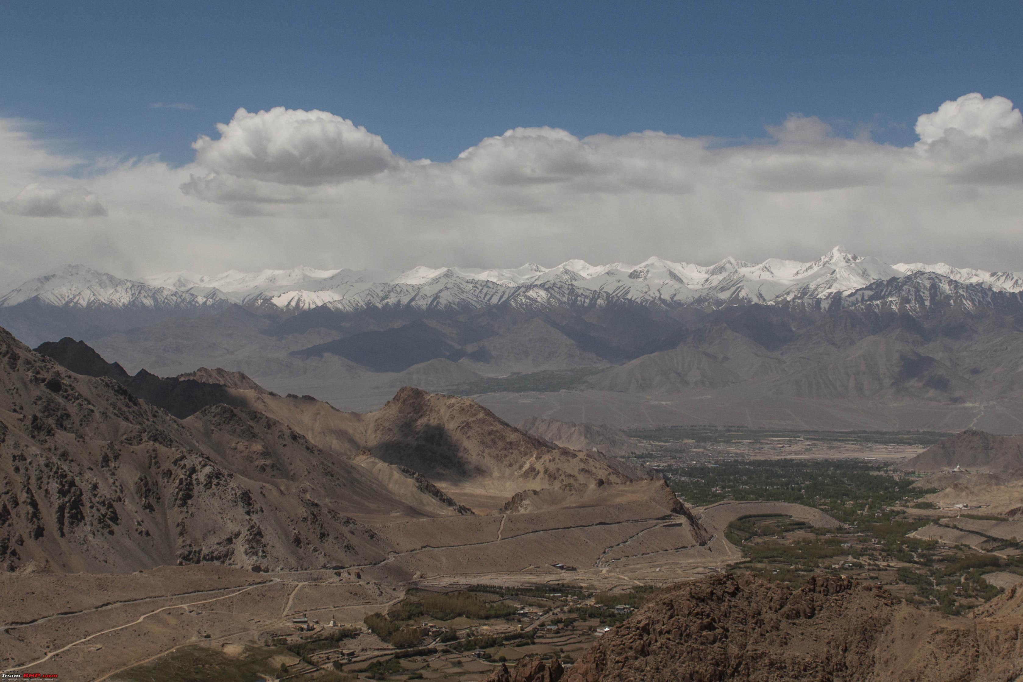 As the altitude increases, snow gradually blends in to the scenery.  And before you know it, you find that you are actually doing through a path cut out in the snow.  The climb overall is a beautiful one provided you keep looking back. The serpentine lines that adorn the mountain that you have climbed are a reminder of the distance that you have crossed to get here.  Just short of the top, there is a small bad patch which was under repair. I guess, wherever there is snow, roads are bound to take a beating!  A little way further and you are at the top of the Khardung La!!   Thereafter it is again down to the North Pullu. Being the beginning of June, there was a lot of snow. Therefore, repair work and clearing work was in full swing. This meant traffic jams and I was forced to halt at an altitude of over 18G feet for around 40 min.  Fresh snow after Khardung La  The Jam at 18K! The results were as expected. A liitle while after we finally started moving down, my little one was howling complaining about a splitting headache! High Altitude Sickness had hit! So what is this High Altitude Sickness really about? The basic is pretty simple. We need oxygen to survive. The amount of oxygen that is available to us is a function of the altitude we are at due to pressure. At sea level, the atmospheric pressure is about 760mm of Hg. At 10K, it is approximately half that. So, while the chemical composition of air remains practically constant till the upper troposphere, the pressure that this oxygen is available at for us to breathe reduces with altitude and at 10K the pressure is half the sea level pressure. Hence, since the oxygen is available at lesser pressure at our lungs, the amount of oxygen that is absorbed into the bloodstream also drastically reduces. The body compensates in various ways. The rate of breathing increases. Which is why you will find that one is not able to sleep easily. The thing is, breathing is an active function when we are awake. But when asleep, breathing becomes a passive function and therefore becomes shallow. With the body already deprived of oxygen, as the breathing becomes shallow, the body gets into survival mode and wakes you up...all breathless and uneasy! Now, at 18K things are far more drastic. The one organ that is very sensitive to lack of oxygen and with severe deprivation at these altitude, neurological symptoms cut in-a.k.a. sudden severe headaches are one such symptom. Nausea, vomiting and dizziness are other common symptoms. The easiest way to get over these symptoms is to inhale oxygen. At Leh one can find disposable oxygen canisters at most pharmacies. Do keep them handy. 5 min of pure oxygen and my little one was up and running! Dymox and other diuretics basically increase urination which in turn relieves the body of extra fluids which in itself tends to reduce fluid pressure inside the body because of reduced atmospheric pressures at higher altitudes. So while diuretics help in reducing internal fluid pressure, oxygenation is something that it cannot address. A point that needs to be remembered by those who consider Dymox to be the cure all. Therefore, to sum things up, firstly acclimatise. The tips given by tsk1979 in his thread on planning halts during the ascent to Ladakh are extremely important. Thereafter, avoid exposure to extreme high altitude i.e. anything more than 14500' which means no leisurely photo sessions on top of passes; 10 min is the absolute maximum that one should spend at these heights. And lastly, keep oxygen handy. You may not eventually need it. But if altitude sickness hits you, nothing other than that will really help. Well after that short "incident" we were up and running. The roads from South Pullu to the North Pullu are bad but easily drivable other than in areas of black ice. One needs to be really careful here since traction is non existent. Do keep a sharp watch on the behaviour of the vehicles ahead and choose your lines wisely. At North Pullu, you will find a military camp. In case of any medical or other emergency, feel free to walk right in. They have a full fledged setup of medical facilities and will help you out in case of breakdowns as well.  At North Pullu Afte that, it is a brisk drive past Khardung village and Khalsar. The mountains turn brown again as you come down from Khardung La.  The rolling browns!  Views enroute Khalsar (see the wild Yaks?) Shortly thereafter, you hit the bifurcation to the Shyok and Nubra vallies. I took the left towards Hunder. Immidiately after the turn, there is a lovely stretch of straight roads before you hit Diskit.  Before Diskit After this you climb a small bit where the Shyok valley comes to view!  First view of the "desert" before Hunder  The confluence of the Shyok and Nubra Vallies  The Shyok Valley A short sprint thereafter and I reached my destination of Thoise which ended this leg of my journey. I was eagerly waiting for the next morning. I was to tread on the land given to India by Capt Chewang Rinchen so to speak! Last edited by neel385 : 26th June 2017 at 15:21. |
|
| (6)
Thanks
|
| The following 6 BHPians Thank neel385 for this useful post: | aniket17, darklord, GTO, Samba, sayakc, YanTra Makto |
|
23rd June 2017, 19:11
| #8 |
| BHPian | Re: L.A.D.A.K.H.E.D. at Last!! Part V : Turtuk and beyond The next morning was the trip to Turtuk and beyond! It would not be proper to proceed without touching upon the history of this area. Till 1971, India was till the village of Chalunka. Beyond that was Pakistan and its province of Baltistan. The map was altered by the efforts of one man. Major Chewang Rinchen Maha Veer Chakra and Bar, Sena Medal.  Maj Chewang Rinchen MVC and Bar, SM Chewang Rinchen joined the Army as part of the then Nubra Scouts at the age of 17 as a soldier in 1948. The same year, due to his exploits during the Indo Pak war, he gained promotion to the rank of Subedar and earned his first MVC. He was commissioned as an officer in the regular Army in 1969 as a Major in 14 J&K Rifles. He went back to his native unit, the Ladakh Scouts since he could not bear the heat of the plains! His unit was responsible for the defence of the Nubra Valley in the 1971 war. Displaying extraordinary tactical sense and planning, he along with his team called the Dhal Force were able to capture around 800 Sq Kms of Baltistan from the Pakistanis. He was instrumental in the capture of a feature called Pt 18,402 which till date is the highest point captured by the Army. His exploits in the war earned him his second MVC. When the ceasefire was announced, he had crossed Turtuk. Had it been left to him, the whole of Baltistan would have probably been in India today and Siachin would not have been an issue. The full story can be found here. http://www.rediff.com/news/slide-sho...20111222.htm#1  The route.. We set course towards Turtuk from Thoise on a cloudcovered morning on account of a WD which had hit the previous night. The mountain tops were covered with clouds giving the area a surreal look. Keeping the Shyok along us we went along towards Turtuk.  Towards Turtuk First comes the villages of Skuru and Udmaru across the river.  Villages of Skuru (R) and Udmaru(L) after which comes the village of Chalunka, the limit of Indian territory pre Dec 1971. Thereafter is the village of Bogdhand. It appears that during the 1971 war, the entire village population left for Pakistan overnight after the fall of Turtuk save the headman and 3 others! Further ahead lies Turtuk. The roads are beautiful with jagged rock faces lining the roads. 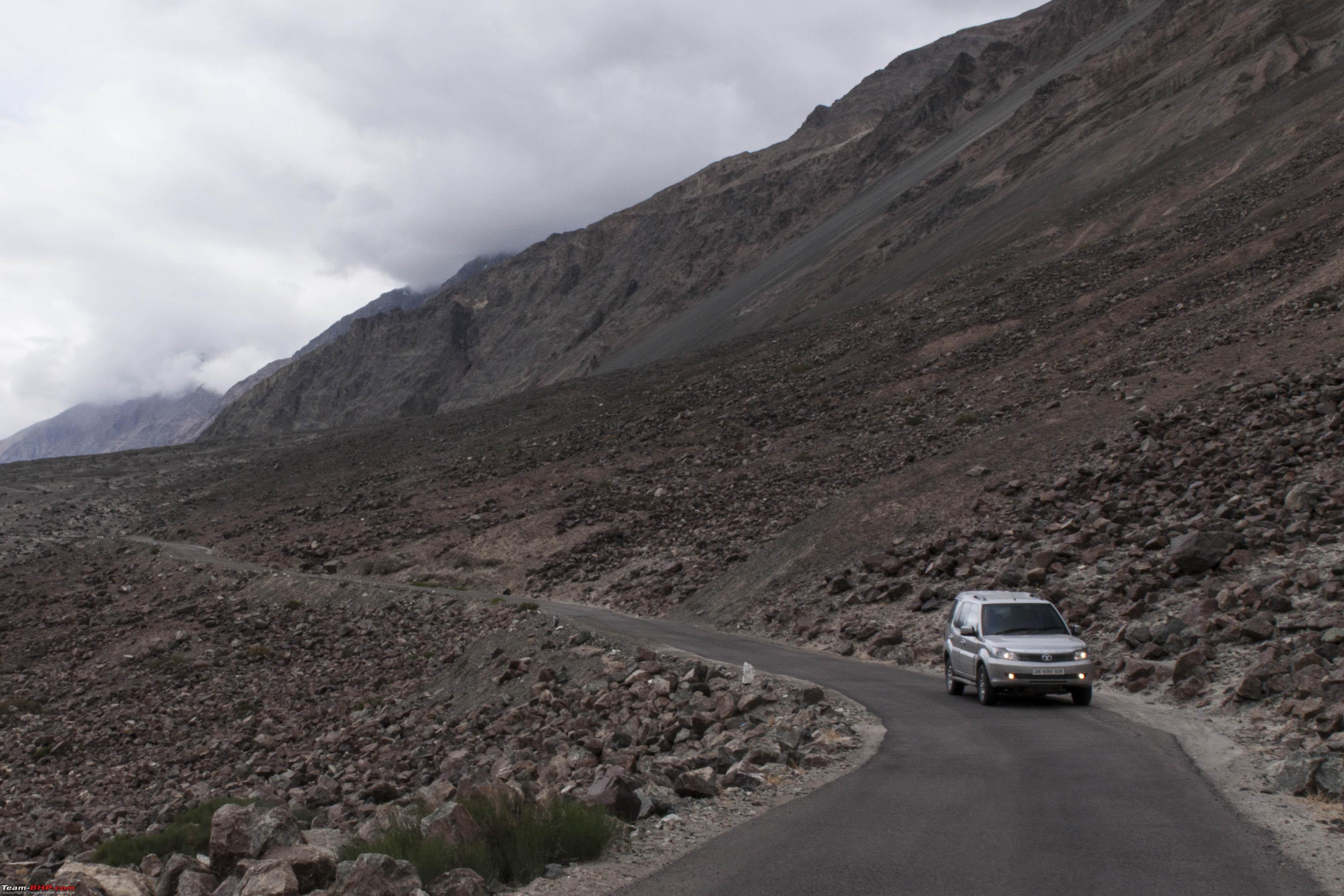   The roads less travelled..      Views along the way If you know someone in the Army well and he is able to get permission for you to go beyond Turtuk, you go to Tyakshi and beyond till a point called 0 RD or O Road. The place where the road literally ends. From here, you get to eyeball Pakistani defensive positions across the LOC.  At the LAC  Enemy posts along the ridge  Communication lines along the mountain face Back at Turtuk, we went into the village for a brush with royalty! The royal family of the Yagbo Dynasty have their Palace in Turtuk with the royals still living there. They are a friendly people who willingly allow visitors into their palace cum residence and show them around.  In Turtuk Village  Dried chillies for the winter!  At the Turtuk Palace   In Royal Company! The Queen guides you around the palace which is really a dwelling today, but, they have made a small museum of whatever they have left post the enemy plunder in 1971.In the museum one sees the family tree of the Yagbo Dynasty and various other nick knacks. The royal headgear and the intricate composite bow did catch my attention!  The Yagbo Family Tree  Battle gear of yore..  The "composite" bow!  Royal Headgear! We spent some time in this delightful company getting to know the people a little bit more and thereafter set course back. Noticing that the evening was still young by the time I neared Thoise, I pushed on till Hunder to do what must me done in the Nubra Valley...camel ride!  Camel Ride Time! In case you are a first timer please remember that unlike the pony rides in Juhu beach which is run by boisterous pony wallas, in the land of the Lamas, things are much better organised. As you reach the starting point, do not rush towards the camel herders confident with the belief that your enthralling smile will get you a quick ride. Instead, look back along the way you came and you will probably see a couple of local gentlemen sitting on a bench with a money bag and tickets. Now, the tickets are numbered, so if you come directly to the ticket man as against going to the camels and then getting sent back, you are sure to save some time in getting your ride! Camel ride done, we called it a day which brings me to the end of this leg of the journey!! Tomorrow, another adventure beckoned....Siachen!! Last edited by neel385 : 30th June 2017 at 19:55. |
|
| (5)
Thanks
|
| The following 5 BHPians Thank neel385 for this useful post: | ganeshb, GTO, Samba, sayakc, YanTra Makto |
|
30th June 2017, 21:43
| #9 |
| BHPian | Re: L.A.D.A.K.H.E.D. at Last!! Part VI : To the Siachen Base Camp  The route.. Siachen is one place or rather one "thing" that I always wanted to see for myself. Having taken so many lives over the years and having been such a hot topic of discussion in the recent past about the futility of really holding on to this strategic piece of territory, I wanted to get a sense of what this was all about. The journey stated with us starting towards Hunder and then continuing till Khalser from where we now took a left to enter the Nubra valley. The beauty of Ladakh is that though one really moves from one valley to another, each has a distinct character which renders each drive a totally different feel. So even though the Shyok valley was just a day old, we never felt that we had seen any of what we were seeing before!  Chortens near Diskit  Nubra Valley..first views From Khalser, one quickly reaches Terith and thereafter one crosses Sumur and Panamik. The drive is beautiful as always and The Nubra valley, being much wider than the Shyok valley, lends a very different feel to the drive. Since Siachen was the main point of interest for me, I did not really spend much time on the places enroute. While I had read of the hot springs at Panamik, I got very mixed reviews from the people familiar with it, so I gave that a miss too!  Crossing Terith  Sumur 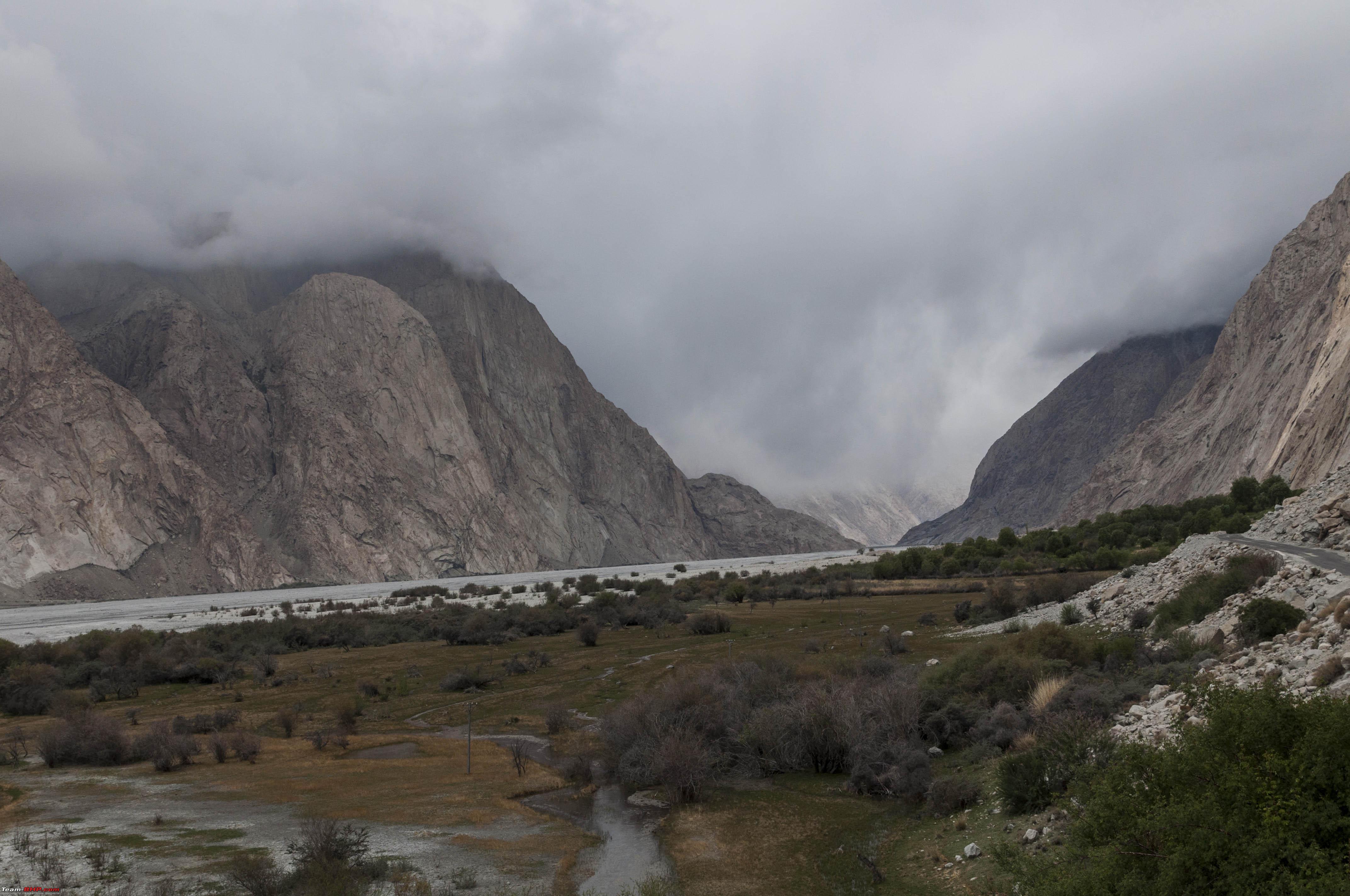 Enroute Panamik After Panamik, the road ends for anyone who does not have some inroads into the Army and has thus been able to get prior permission to go further which, if you know someone, is not very difficult. So crossing Panamik, you continue down the same road, which increasingly becomes desolate. The scenery however more than makes up for the lack of human habitation and each turn really is a different sight. Another interesting thing is that quite some distance before you actually see the glacier, signs of glacial erosion is visible to the eye. There is moraine strewn around the valley floor, the walls of the valley show signs of glacial erosion and it is in this magical environs that you suddenly turn a bend an see a giant flag of India in the distance, and besides it, a speck of white. The distance makes the giant seem unrealistically small, beautiful and dignified and thus it takes a moment to realise that the small speck of white is the Siachen Glacier.  Enroute Siachen  Siachen Glacier...first view Thereafter, it was a sprint to get to meet the monster called Siachen Glacier! When I got there however, I was greeted by the strangest ATC I had come across till date!  The highest ATC in the world! Next stop was the OP Baba Mandir. Who the soldier remains a mystery, but when operating in conditions as harsh as that In Siachen, one needs any strand of hope and belief one can find I guess!   At the OP Baba Mandir 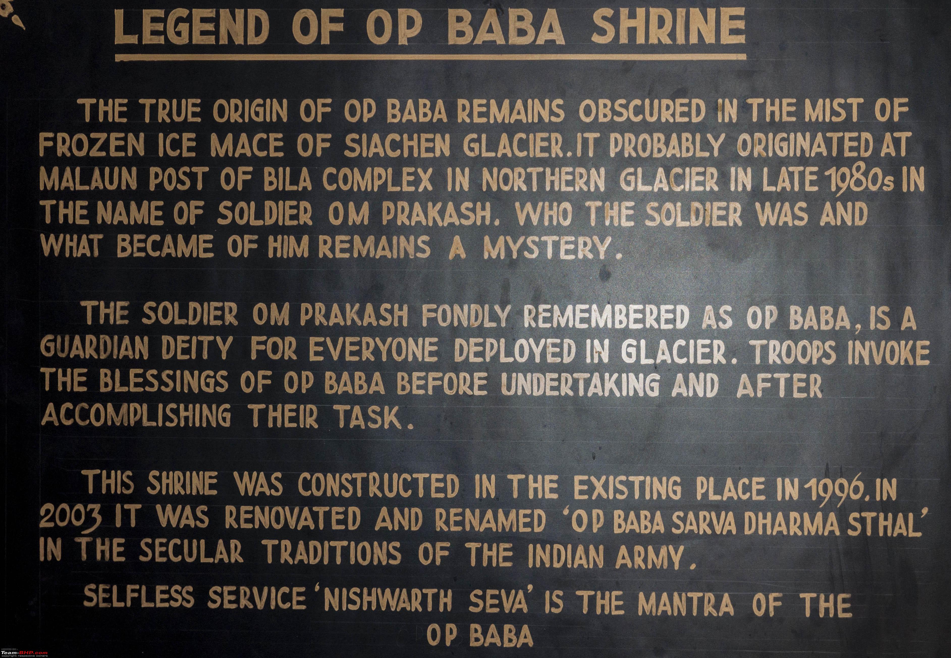 The OP baba story  The room of OP Baba Thereafter, it was onto the snout of the Glacier...  The Siachen Glacier We spent some time at the glacier really trying to get a feel of its enormity and monstrosity. And it was time well spent.  The boys trying to tame the glacier!  The Beast...with the Beast! Thereafter we visited the memorial at the Base camp.  The war memorial After which we set course back to Thoise.   The views on the way back Approaching Hunder, we decided to get some quad biking done! Theer are three such operators as you come from Khalser towards Hunder. I personally preferred the last operator since his area of operations take you through some big dunes which he transverses at the fastest possible speeds!  Quadbiking! Thereafter it was back to Thoise which brings us to the end of another excitement filled day! Last edited by neel385 : 2nd July 2017 at 22:17. |
|
| (7)
Thanks
|
| The following 7 BHPians Thank neel385 for this useful post: | darklord, GTO, jaganpec2002, Nariman, Samba, sayakc, YanTra Makto |
|
23rd July 2017, 11:02
| #10 |
| BHPian | Re: L.A.D.A.K.H.E.D. at Last!! Part VII : Thoise to Pengong Tso Having gone through the write-up of Tanveer about the region, I was aware of two routes to get to Pengong without getting back to Leh from the Nubra valley. These were the Agham - Shyok and the Agham - Shakti routes. Now, the Agham Shyok route was the shorter, more beautiful route which I was interested in, however, the route was supposedly extremely difficult for anything but a rugged 4X4. Hoping that things had changed from the time the report was written, I started to enquire about the route from the local Taxi drivers and it soon transpired that the route that the local Taxi drivers were taking was indeed the Agham Shyok route for Innovas and Taveras! If the Innova and Tavera could make it, surely so could a Safari. So Agham-Shyok it was to be!  The Route.. So around 0830 hrs, we set off from Thoise. Initially we retraced our steps back to Khalsar ahead of which we now took the left turn towards Agham. The roads in this stretch are nice and tarred and one slowly makes way to the bottom of the Shyok valet till the road just about runs along the river. The terrain is beautiful and long straight stretches of tarred road surrounded by stark mountains and noting else makes for a mesmerising drive. Once in a while one does come across an unpaved portion where the BRO is working, but itherwise the roads are great. Great till Agham that is.     Views enroute Agham At Agham, another sleepy little village, a road forks out to the right that takes you to Shakti, but being Shyok bound, we soldiered on! And then we came to the bad patches! One needs to understand a little bit of geography to understand the rather unsurmountable task that building and maintaining roads in this part of the world amounts to. The basic structure of the earth is sedimentary, and a close inspection of the mountainsides will reveal that it is composed of small pebbles which have just been pushed up when the tectonic plates collided to make the subcontinent a part of Asia. So these huge piles of pebbles come raining down at any excuse. And the excuse can be a minor tremor or more commonly, rain. This leads to landslides where the entire mountain face comes crashing down to the valley, Shyok valley in this case, and wipes off parts of the road running along the river as and when it feels like! The route from Agham to Shyok had many such patches. Now the tricky part is making way through the rubble. Since the rubble falls on the river valley floor, which in turn is just sand, some patches are extremely tricky and have been known to literally eat up vehicles. Hence, having a local driver who knows the war around these uncharted piles of rubble is extremely important. So, keeping these points in mind, I put my car behind a Tavera with local driver and carried on. Despite the bad patches, the route was spectacular. The patches that were good were real ggod and the patches that were not, well were not, but offered an exciting drive. Don't however expect your better half to share the excitement! I really don't have words to describe the beauty of the route, so I'll try and let a few pics do the talking.     The Bad Patches...amazing drive though!   The Good Patches   Shyok...at last! Post Shyok, the road condition is all good thought he road is narrow and one needs to be wary of oncoming traffic enroute a small climb to cross the ridge after Shyok (forgetting the name of the pass!) till you roll down to Tangse where one can stop for some chow.   Views enroute Tangse Thereafter, it's a run down to the grasslands where you will find Mormots posing for photographs.  Views after Tangse  The grasslands..  Mr Mormot! But the excitement of finally being close to Pengong Tso took over and we barrelled through till we saw this:  Pengong Tso...first view! Once one sees the Pengong Tso, it's very difficult to slow down and so we continued on till the enormous beauty that is Pengong Tso came to view. We continued along the lake to Spangmik which is now a tent town to hunt for accommodation and managed to find a rather decent tent along the lake. Having settled down, I spent the rest of the evening just enjoying the magnificent views!    Views of the Pengong Tso!     The Tents along the Pengong!     Random clicks! And thus the day came to an end; and a pretty perfect day it had been! The drive was amazing and the views at my destination singularly spectacular. Travelling is perhaps best in this form where the journey and the destination are both perfect!! The next day would see me making my way to Nyoma..via Hanle! Last edited by neel385 : 7th August 2017 at 22:35. |
|
| (5)
Thanks
|
| The following 5 BHPians Thank neel385 for this useful post: | darklord, GTO, Samba, sayakc, YanTra Makto |
|
9th August 2017, 20:22
| #11 |
| BHPian | Re: L.A.D.A.K.H.E.D. at Last!! Part VIII : Pengong-Hanle-Nyoma Since I was into taking the beaten tracks, for my way to Hanle and Nyoma, I had decided to follow the route along the Pengong onto Chusul and thereafter onto Chagga La and onto Loma. 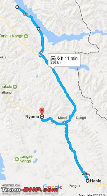 The Route The day started on a not so happy note. As I got to the car to but my bags in, I discovered that the rear right tyre had developed a puncture! My purchases before the trip came in handy for the day was saved by my puncture repair kit and tyre inflator!  Repairs ahoy! However, this did mean that I lost about an hour and so at about 0930 hrs I bid goodbye to the tent guys and set course. And I did not regret taking the more difficult and desolate route one bit ! The views of the Pengong and visits to the Chusul and Rezang La war memorials made it more than worth it! The road is dirt from the very beginning. It is basically a track that joins Spagmik where the tent city is located to the villages of Man, Merak and thereafter onto Chusul and is used primarily by the local population. The journey begins along the Pengong and continues east wards. If you thought that the views of the lake were great till now, the views that now come forth are truly spellbinding. Though pictures they say are more than a thousand words, no picture can really capture the magnificence of nature. But, why not try I thought.      Pangong Tso! Slowly, the track starts to move away from the lake and takes a south easterly route as the lake continues eastwards into China. The terrain now consists of large sand flats.  The sand flats The sand flats continue till the village of Merak and the worst stretches are between Man and Merak. Local gen came in handy here. A local driver I had befriended the earlier evening warnes against taking the smooth road across the sand flats. The smooth ones are the ones where cars are most likely to get bogged down, So keep the car along the track that passes over the rockiest terrain to be safe from sand traps. Exactly what I did and stayed safe. The drive once you leave the lake becomes strikingly different. You are now in the thick of the Changthang High Altitude Desert. Deserts are inherently beautiful, unless one is stranded in it of course! And this route gives you a good sense of both. The scenery is enthralling. Clear blue skies, lofty, often snowclad mountains, sparse vegetation, occasional wildlife in the form of Kiangs enthral ones senses. At the same time, this drive is carried out all alone! In the entire route, I did not cross any other vehicle. And the distance between places, though not much on paper takes a long time to cover, and that too in a vehicle! Walking for any length of time in these > 15G altitudes is a task in itself. So the feeling of doom in case the vehicle breaks down is very real. So a well maintained and up to shape vehicle is a must as is essential supplies such as food and water. So, soaking up the views, we chugged along. A lone telephone line kep us company. More on this line later!   The views enroute Chusul Till finally Chusul came to view..   Chusul After Chusul we turned left towards Tsaga La and just outside the town lay the Chusul War Memorial. This memorial is in remembrance of the sacrifices of the brave men of the Indian Army who laid down their lives in the defence of this area in the Sino Indian conflict of 1962. However, the real memorial lay further ahead.  At the Chusul War Memorial Though Google Maps shows the route as a good motor able one, the road condition shows no change. Just a track. And just as good if you ask me. A good tarred motor able road in this barren rugged beautiful and unspoilt place would somehow seem out of place! The terrain becomes more barren and rugged as one continues along the path. And the single track now starts to get blurred. Welcome to the most confusing, exciting and desolate part of the route! The thing is, the IA still maintains a sizeble presence in this area and their trucks ply along the length and breath of the valley to their far flung posts. And this is where the telephone line becomes a lifesaver. But this is all in hindsight! I was mortally adverse to take any left where ever the tacks bifurcated lest I wander into China as had been advised by Tanveer. And always taking the right lead me to some crazy dead ends which I had to back track. So keep track of this telephone line and follow it wherever it goes. Slight detours will be required to stay away from soft ground (remember the advice of the local driver?), but, don't wander too far away from it! So off we went enjoying and yet awestruck to the point of being slightly scared of this barren beautiful landscape.    Enroute Rezang La In fact, if you look up to your left, you can actually see the defensive positions laid out by the Army on the crests of the valley. This is how close we are to the Chinese border. And this is why this ground is hallowed.  Pill Boxes And then Rezang La war memorial comes to view. The Battle of Rezang La is counted amongst the finest displays of bravery, spirit and devotion to duty that has been ever displayed anywhere in the world by fighting men. On 18 Nov 1962, C Company of 13 Kumaon put up the ultimate final stand in the defence of this position. Out of the total company strength of 121, 114 were killed, six were captured and one was sent back by the Company Commander Major Shaitan Singh to the formation HQ so that the tale of the brave Aahirs could be told. Some estimates put the enemy numbers at over 5000. But the brave men, though vastly outnumbered and our gunned, without artillery support or backup reserves put up a fight for over 5 hours. The frozen bodies were found by a shepherd over a year later. All 114 with their weapons in hand. Every soldier carried multiple gunshot wounds. The Company Commander lay with his men. Interestingly, all 6 who were captured managed to escape. More details of this battle can be found here: http://strategicstudyindia.blogspot....13-kumaon.html  Major Shaitan Singh PVC  Paying my respects..  Even the children seemed to sense something.. After spending some time at the memorial, we started off again. The views were just as spectacular till we finally crossed Tsaga La.   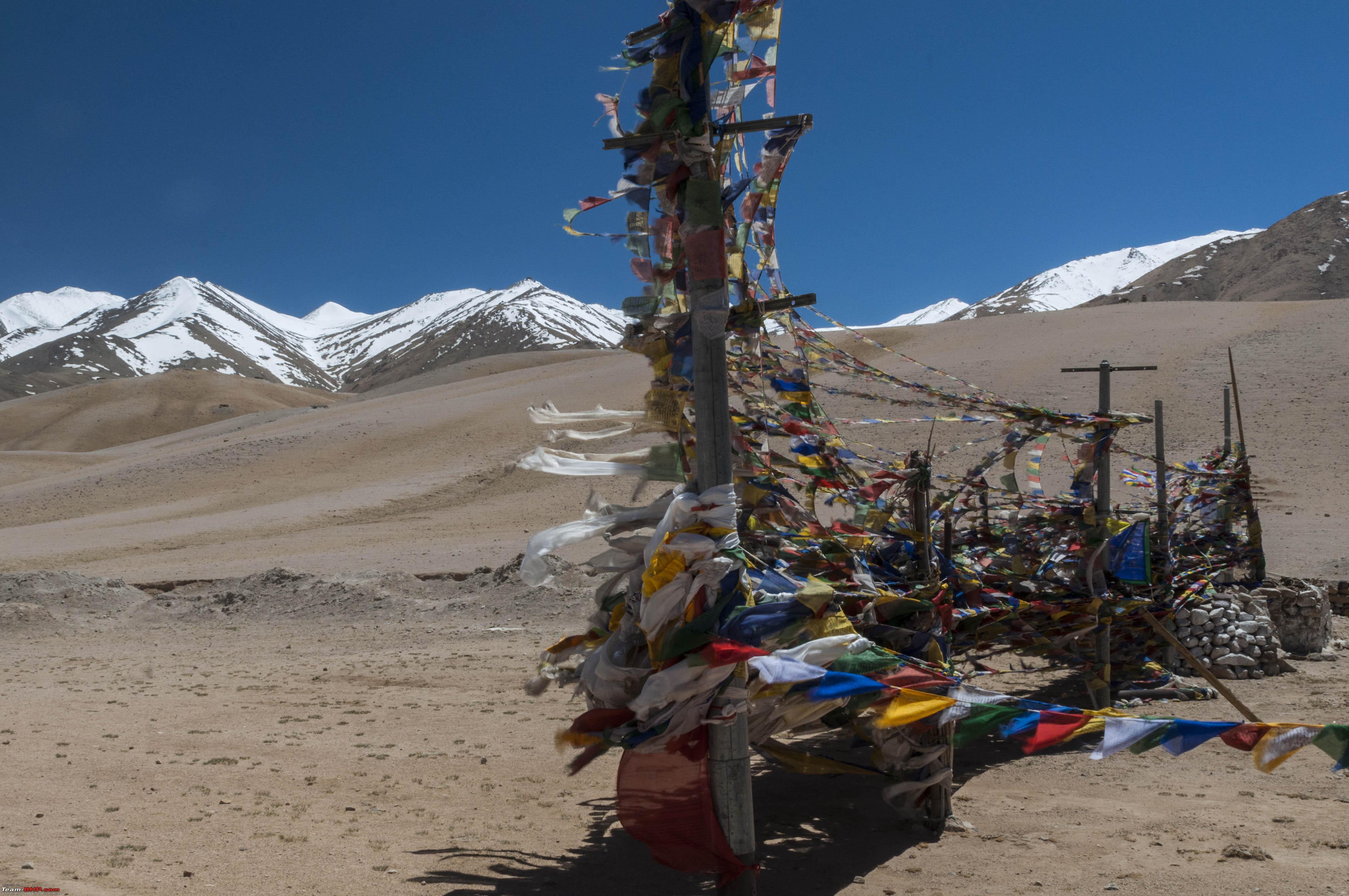 On the way and along.... Tsaga La (note the telephone line!) Shortly after crossing the pass, the track converts itself into a red unpaved road which thereafter leads to a tarred road...after ages it seems.. 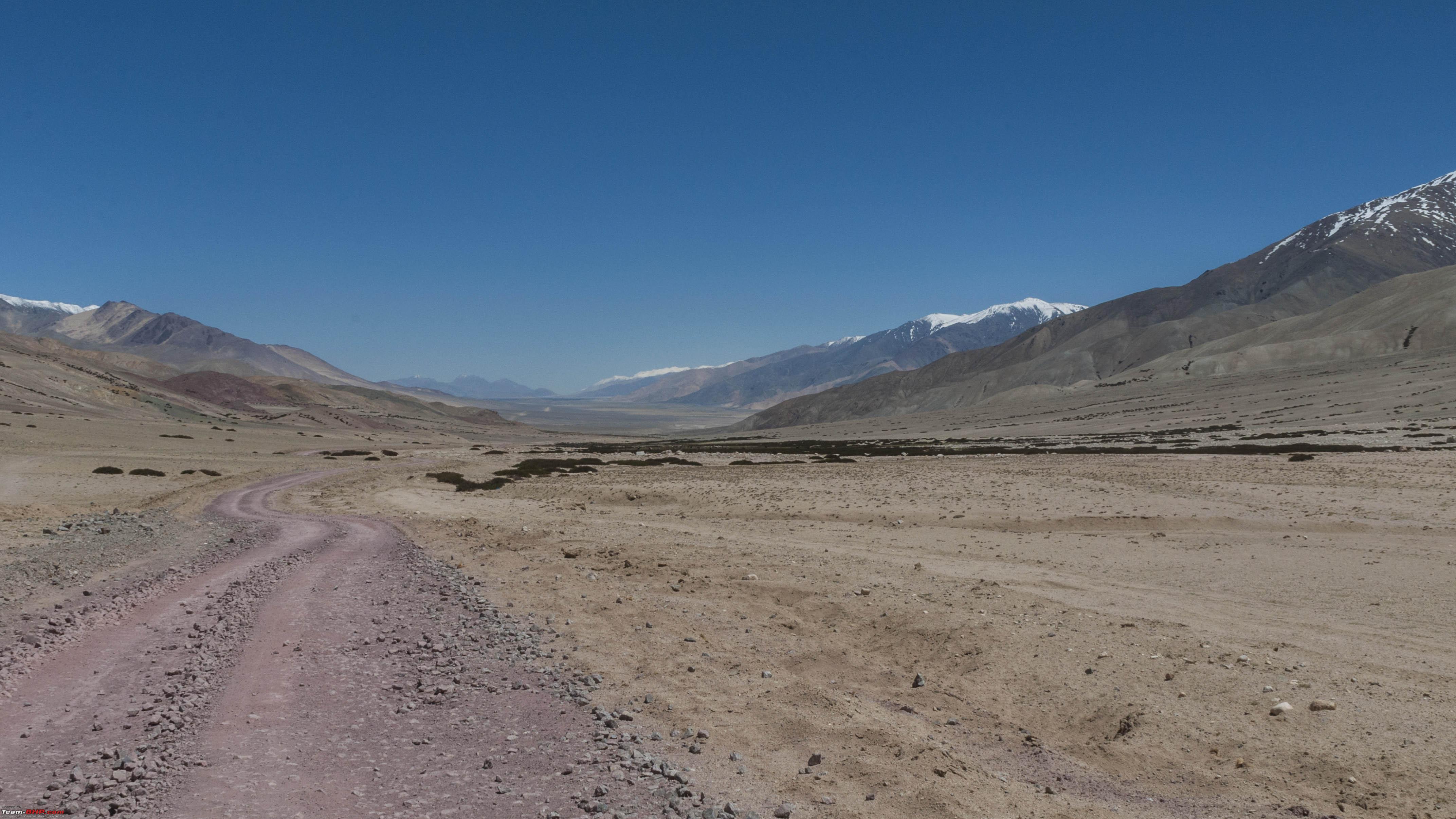   The Red Road, views along and near Gandpa Gompa Last edited by neel385 : 13th August 2017 at 13:52. |
|
| (7)
Thanks
|
| The following 7 BHPians Thank neel385 for this useful post: | AlphaKilo, darklord, GTO, Nohonking, Samba, sayakc, YanTra Makto |
| |
|
10th August 2017, 22:31
| #12 |
| BHPian | Re: L.A.D.A.K.H.E.D. at Last!! Thereafter, the magnificence of the Changthang desert comes forth in all its glory. Till now, the desert was basically in the form of sparse vegetation and barren landscapes. Hereafter, sand and lots of it further adds to the beauty. The roads are better now, but the going is often interrupted by sand that has been swept onto the roads by the strong winds.    The Changthang Dessert enroute Loma So continues the journey till a blue channel makes itself visible along the road which quckly broadens to form a river. The blue Indus. Its quite a contrast. The barrenness of the desert and the soft life giving force of the river. Vegetation makes itself visible along the river basin as do animals and birds. The awesomeness and magnificence of mother nature in all her glory.     The Blue Indus enroute Loma So continues the journey till one sees a bridge across the Indus. This is Loma.  Approaching Loma From Loma, which is really just a checkpost and nothing else, I took the left onto Hanle. The drive onto Hanle was even more spectacular than the drive till now. If that is even possible! The drive is basically through a valley with pretty straight well tarred roads. Its the surroundings that is spectacular. The barrenness of the Changthang desert slowly gives way to meadows which are dotted by wild Kiangs and large flocks of Pashmina goats that are left for grazing by the nomadic tribesmen who heard them. Once in a while, one finds these tepee tile tents in which the herdsmen and their families stay. This was truly an ideallic fairy tale like land!       Drive onto Hanle So continues the drive till at the far horizon one picks up a gleaming white fortress like monastery on a lone hill. This is the imposing Hanle monastery.  The Hanle Monastery Going around the hill, one comes up to the Radio Telescopes and the Observatory that Hanle is famous for and further ahead lies the village of Hanle. It was 1530 by the time we finally got here and since we did not get anything at our planned pitstop at Loma, we chowed down some hot Maggi at a local store.    The Observatories and Hanle village After the rather late lunch, the sun was already dipping down towards the west when we set course back to Loma and further to Nyoma. 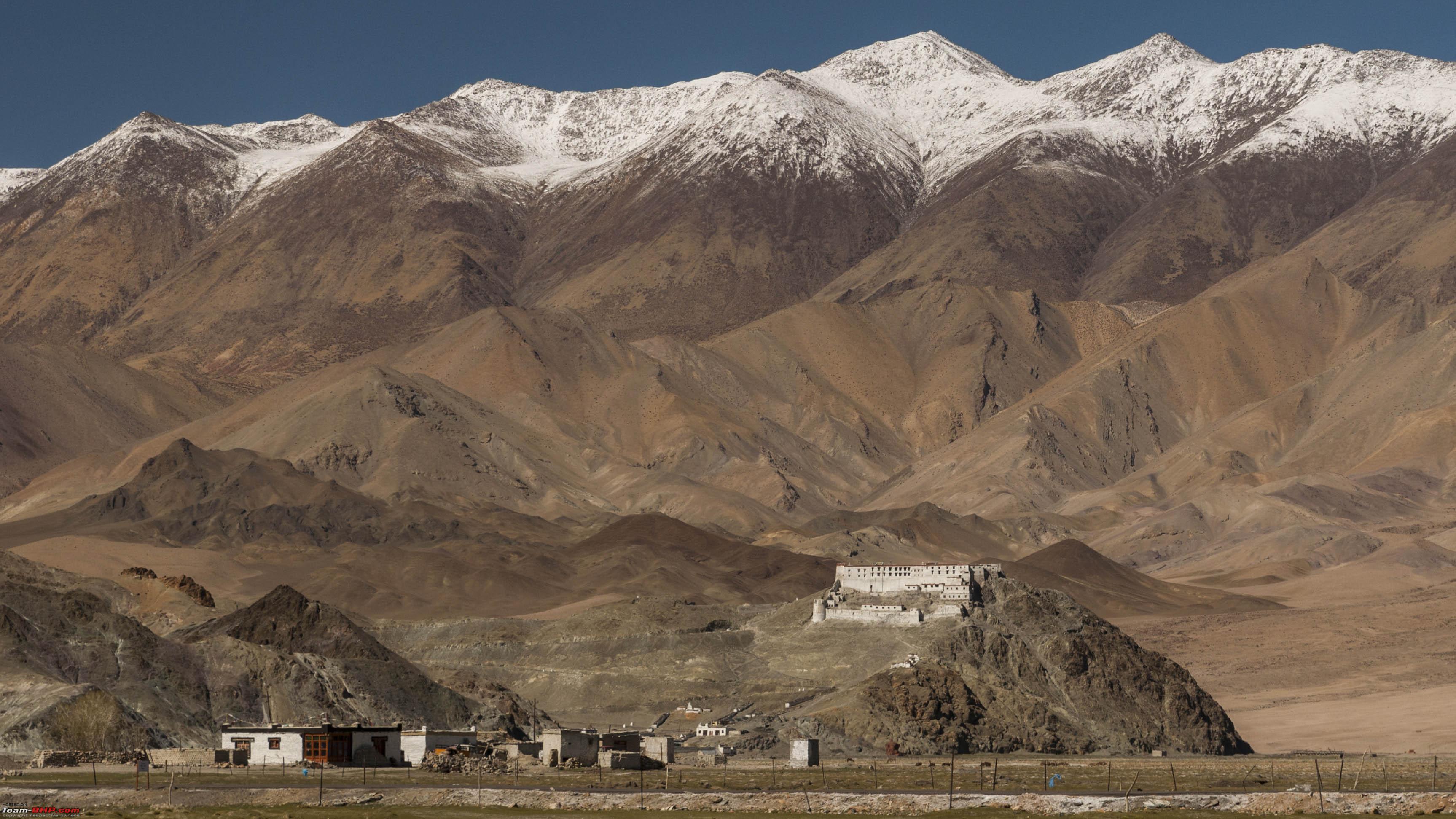  Views on the way back.. Reaching Loma, we now continued straight on till, at around 1900 hrs, we reached Nyoma.  Nyoma Monastry So ended our about 10 hr drive through perhaps the most beautiful, lonely and exhilarating roads that I have seen in this trip. In fact, I cant even compare this trip to any I have taken earlier. The route was amazing on several counts. Firstly there is the loneliness with nobody and I mean nobody around for hours. Then there is the stark beauty of nature. And lastly there is the vivacity of colours and terrain and textures that are truly mind blowing. A much required rest was at hand now! Last edited by neel385 : 13th August 2017 at 15:03. |
|
| (10)
Thanks
|
| The following 10 BHPians Thank neel385 for this useful post: | AlphaKilo, amit_purohit20, darklord, GTO, jaganpec2002, Nohonking, Samba, sayakc, YanTra Makto, YDS |
|
13th August 2017, 16:04
| #13 |
| BHPian | Re: L.A.D.A.K.H.E.D. at Last!! Part IX : Nyoma to Sarchu So it was the last day of the trip before setting course back towards the planes. The plan was to see Tso Morri, Tso Kar and thereafter get to the Leh Manali route and get to Sarchu for the night.  The route.. We set course from Nyoma at around 0830 hrs. With the Indus keeping us company, the drive was beautiful.     Views enroute Mahe Mahe is just a small checkpost, which is so inconspicuous that we actually missed it. But along with it lies the only bridge across the Indus in this region, so once you see the bridge, you know it's Mahe. Once you cross across the Indus, the valley becomes narrow and on oyu continue till reaching the village of Sundo.   Onto Sundo From Sundo, we again took a right to set course for Tso Morri. The roads are broken stretches of tarmac. More broken than tarmac really and the terrain barren and beaten. So it's quite a refreshing sight when turning a corner, you see the beautiful Kyagar Tso!  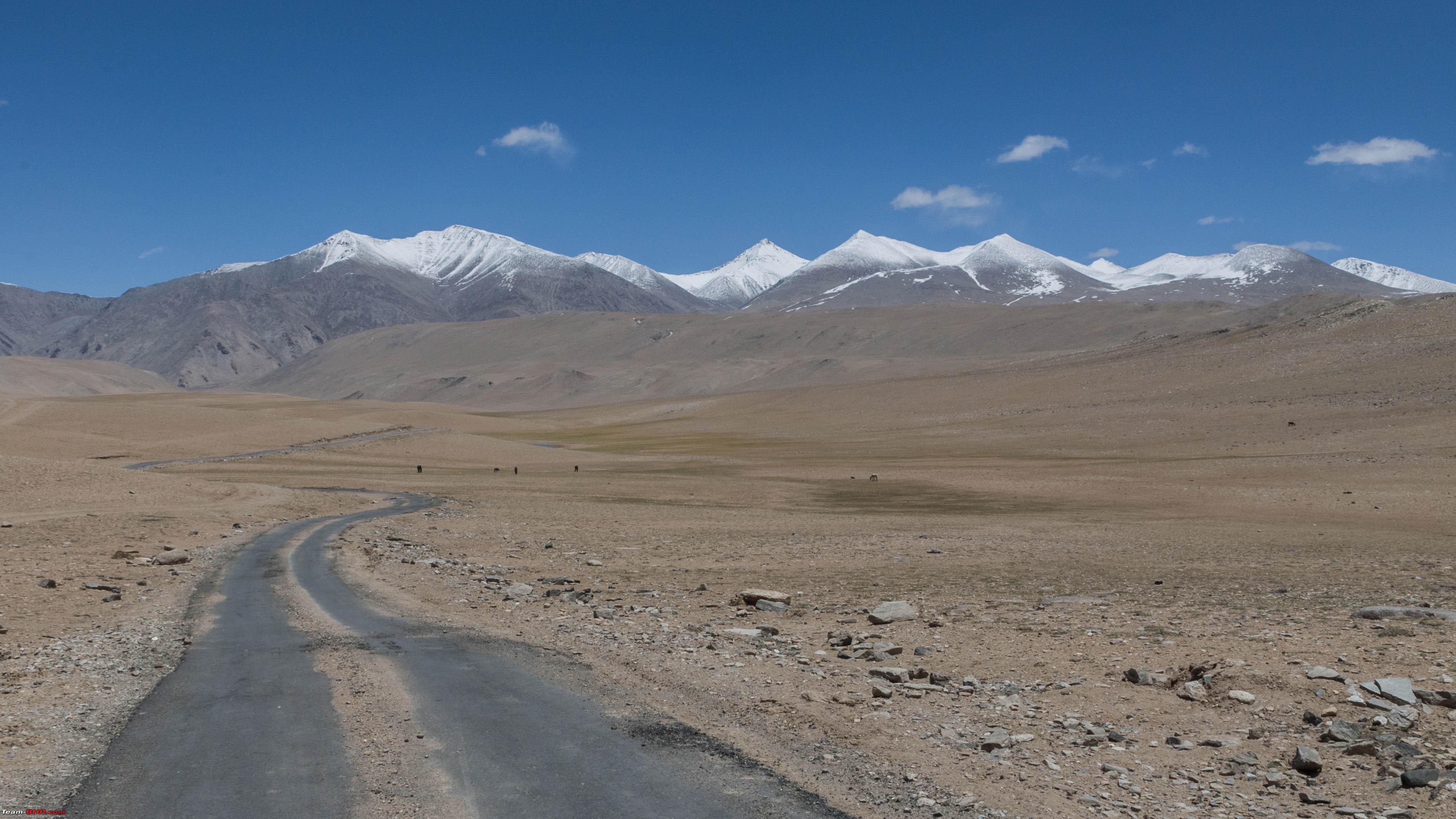   The barren roads and the refreshing Kyagar Tso! Thereafter the road degenerates to a track and another 20 km or so, you reach Tso Morri.   Tso Morri I turned back after getting a glimpse of the Lake basically because I had to reach Sarchu by nightfall and I did not want to reach late at an unknown place with my wife and kids! So back it was till Sundo from where we now took a left towards Pologongka La pass. Initially the roads were beautiful and tarred till we crossed Puga. The grasslands and springs were again lush and green and were teeming with birds and other wildlife.    The grasslands near Puga..and the roads beyond Thereafter the it was again dirt roads. And these were perhaps the toughest dirt tracks that I have had to encounter. The reason behind this is that there is road work in progress which meant deep ruts from the tracks of the bull dozers and a lot of loose soil that had been thrown onto the track for road construction. All this coupled with stiip inclines and very sharp bends which I had to negotiate while climbing really did test by driving abilities!   Testing roads onto Tso Kar After the pass, the road continues to be rather hellish, but the sight of the Tso Kar in the distant horizon does somewhat lift the spirits.    The Tso Kar So down we barrelled along till we were driving along the lake. Surprisingly, the lake was almost dry. Was I too early in the year for water to be in the lake? I had also seen pics of a dry Ryul lake and Chilling Tso lakes because of which I had decided to cancel the detour for these lakes. Or was this a more ominous effect of global warming?   Driving along the Tso Kar Thereafter we reached the small village of Thukje where we again met tarred roads and from there we continued onto Debring to get to the Leh Manali highway.   Thukje and roads beyond! A little while later Debring and the Leh Manali highway came to view. The feelings were mixed. The journey was over. So many days of planning and exhilaration, going through what were really life experiences, the agony of tough roads, the ecstasy of beautiful locales, the excitement of reaching a destination, the excitement of new roads every day...it was over. But all good things come to an end. So is the law of the jungle.  Reaching Debring..the Leh Manali road on the left.. Turning left, we were directly onto the Morey Plains. And this was a wonderful relief after the tough roads so far. And enjoyed it I did!   The Morey Plains! After the plains, it was down a series of switch backs onto the lunch time destination of Pang.   Enroute Pang Last edited by neel385 : 13th August 2017 at 17:56. |
|
| (6)
Thanks
|
| The following 6 BHPians Thank neel385 for this useful post: | darklord, GTO, Nohonking, Samba, sayakc, YanTra Makto |
|
13th August 2017, 18:30
| #14 |
| BHPian | Re: L.A.D.A.K.H.E.D. at Last!! After a delicious lunch of Daal Chawal at Pang, we hit the road for Sarchu. The roads in this stretch were a hit and a miss. Some stretches were good, while others were not. The Manali highway was still not officially open and road work was going on in the bad patches and so the road conditions were expected I guess. So off we went along roads where the bad condition was more than made up by the stark and beautiful landscapes. There were beautiful valleys and stark rugged mountains that kept us company.      Pang and beyond Soon a climb ensued and we were on our way to the Lachung La and thereafter the Nakeela passes. Snow was fresh here as well and the road was with snow walls on both sides. A sight we were well familiar with by now.       Crossing Lachung La and Nakee La Shortly after Nakee La came the Gama Loops! Now, if you take a close look at the pic, you will notice a track made by some vehicle which basically takes a straight route from the top of the loops till the bottom! Wonder what vehicle made that!!  The Gama Loops...note the track! After the loops, it was a straight run till we reached Sarchu...our destination for the night!    Onward...to...Sarchu! As it turned out, the decision to cut the journey to Tso Morri short and reach Sarchu by sundown came in handy! There was only one "Family Accommodation" in Sarchu, others being dormitories. And we got that!   The "Family" Tin Shed! Last edited by neel385 : 13th August 2017 at 18:50. |
|
| (6)
Thanks
|
| The following 6 BHPians Thank neel385 for this useful post: | darklord, GTO, Nohonking, Samba, sayakc, YanTra Makto |
|
13th August 2017, 19:45
| #15 |
| BHPian | Re: L.A.D.A.K.H.E.D. at Last!! Part X : Sarchu to Manali  The route.. And we were finally in the last leg of our journey. Setting course from Sarchu, Baralacha La was the first pass. The roads were ok in the valleys, but not too good as the climb started. But the snow and the views more than made up for it! At Killing Sarai, construction was on in full swing for a bigger higher bridge. So in times to come this area will not remain treacherous. The hills are changing now. The stark colours of Ladakhi hills are slowly being replaced by the "regular" colours that we are used to. The change is gradual, but distinct.   Killing Sarai     Just before Barachang La- the place has a puncture repair shop         Views till the crossing of Barachang La Post Barachang La, you have truly left Ladakh behind. But for the one jem called Suraj Tal just after the pass, things are becoming green.  The Suraj Tal Couple of switchbacks and Zing Zing Bar later, you are driving on a typical Himalayan valley with pines and greenery around. We stopped at Sase for breakfast and after a hearty one, continued towards Keylong and further towards Damphug (written as Gramphoo in tsk's post)  Switchbacks at Zing Zing Bar  Breakfast at Sase     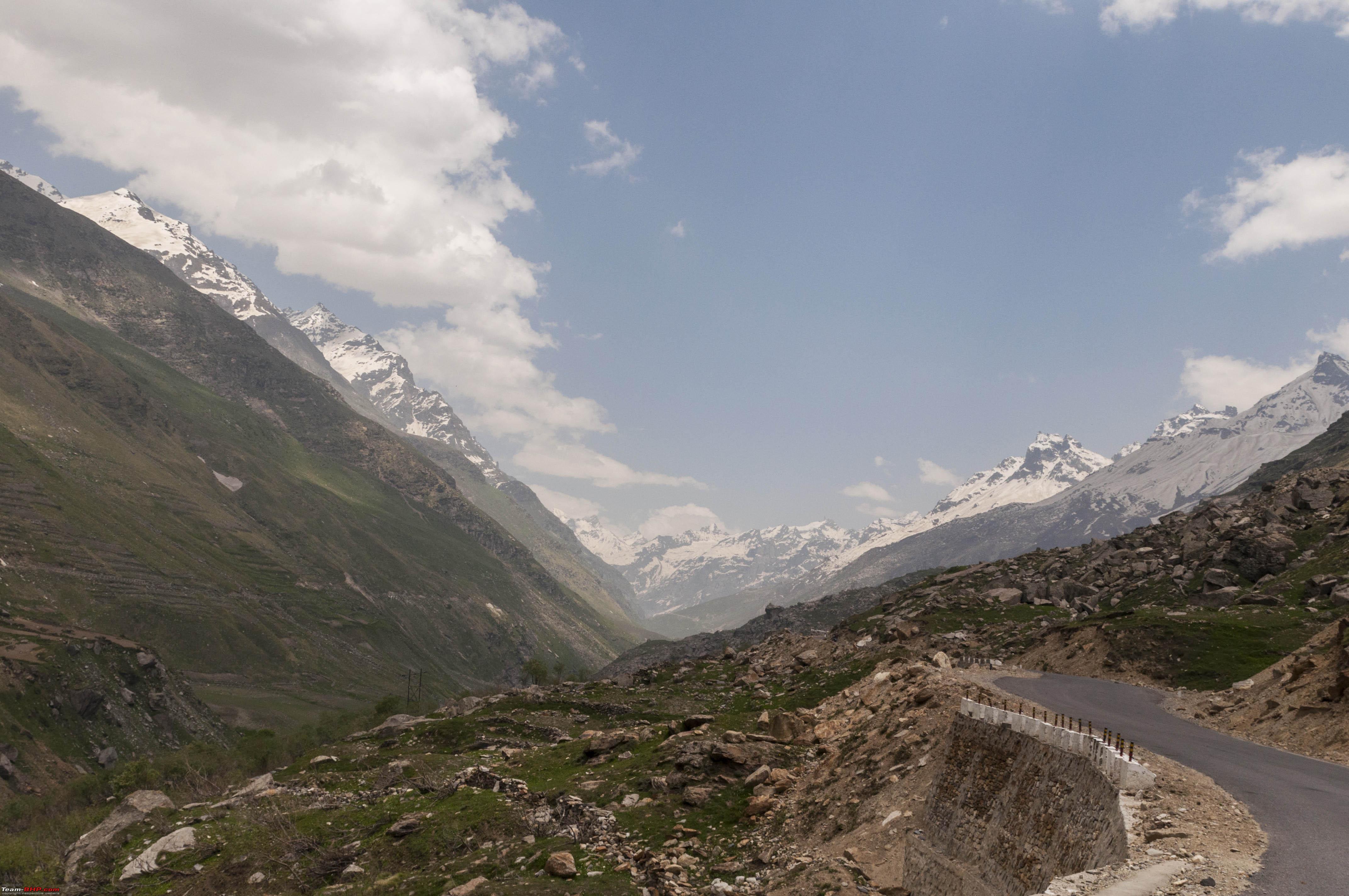 Views till Damphug Thereafter, it was straight up the Rothang Pass. Like I said earlier, the pass was not officially open and so road work was in full swing. This also meant that the repairs has not been completed. Conditions were naturally tough for the car and the driver if I may add. Also one will find drivers from the hills who have just about crossed from the Manali side ever so exited to have made their first pass crossing and will thus be in a tearing hurry to bet to the bottom of the pass. Keep a sharp lookout for these dangers and if you see one coming, specially when you are climbing up a switchback in first gear and full throttle, prepare to have your driving skills tested!     Up the Rothang Pass Finally we reached the top and shortly afterwards we gor the first look at "normal civilisation" after about a very peaceful 10 days!  The Rothang Pass  Back to civilisation Last edited by neel385 : 13th August 2017 at 20:30. |
|
| (18)
Thanks
|
| The following 18 BHPians Thank neel385 for this useful post: | amit_purohit20, amrisharm, bj96, darklord, grkonweb, GTO, ike, jaganpec2002, jaunthead, mustang_shelby, narayan, Nohonking, PraNeel, Samba, v12, wolg, YanTra Makto, YDS |
|