| |||||||

| Search Forums |
| Advanced Search |
| Go to Page... |
 |
| Search this Thread |  15,136 views |
 30th January 2022, 00:40
| #1 |
| BHPian Join Date: Dec 2019 Location: Kolkata
Posts: 56
Thanked: 328 Times
| Jeepers' tryst with Spiti Valley PrologueAs the first light of dawn diffuses through the misty window panes of Tara Homestay and a smell of fresh snow permeates through the window, just opened to check the weather outside, I wake up to a cold chilling breeze only to get mesmerised by a white and misty Pin Valley stretched out to the almost invisible Parvati range. Soon the chill in the air brought me back to my senses reminding me it was about -8°C last night in Mud and we have miles to go through snow and rain before we could reach Kaza. Seems just yesterday we have been yearning for a white Pin Valley while planning for Bhaba Pass trek in pre-COVID era.  A white Pin Valley  Trailhawk's date with snow How it all beganIts needless to say, and perhaps a bit of a cliche, that Spiti is a cherished destination for any travel enthusiast or anyone who loves mountains. However, I always believed, that unlike any other travel destination, Spiti is not something just to be ticked off from a bucket list. Spiti is all about getting immersed in a quintessential Spitian experience - perceptible in its small villages, in its hard working and ever smiling people, in its picturesque but treacherous mountain roads, in its struggle for daily life in the most inhospitable terrain and harsh weather and of course, in its unique culture and local cuisine. We always yearned for such experience and never wanted to rush through a Spiti trip. But after years of wait, when we could not manage that ever elusive time and as the first wave of COVID strikes at the misplaced invincibility of mankind, we are compelled to put up a compromised plan for Spiti in May 2021 leaving the true Spitian experience for some other time. But the 2nd wave compelled us to push it to Oct 2021. For some hotels, where the cancellation window was closed, we moved it to Oct 2021. Come 15th August, Jeep Freedom drive with Eastern Jeepers Club, when I shared my idea of going to Spiti with fellow Jeepers, many were interested and eventually 6 of us teamed up to go to Spiti in mid October. Preparation & PlanningMy Jeep was in good condition and 3 weeks before the trip I took it for full check up. Accompanied the technician throughout the service so as to brush up my DIY skills which may come handy in remote area. This includes fuse, battery, air filter, suspension, tyres etc. It will be too long to elaborate what tools we carried as there are excellent posts related to those. But some of the important things are 2 L ad-blue cans, 20 + 5 L Jerry can, windshield washer with antifreeze to sustain subzero temperature, 1L coolant, duct tapes, Funnel with spout, critical fuses, changing tent, few spanner and tools, WD40 and working lights. In our team there will be 2 JC Trailhawks 4x4 (including mine), 3 JC 2WD and 1 JC 4X4 . 3 Jeepers will start early and 2 of us with Trailhawk and 1 from Noida will join them in Kalpa. Since October has always been an unpredictable month, especially the later half, initially I planned to do both in-bound and outbound journey via Shimla . But now with a team of 6, we decided to complete the full circuit via Manali. The trip itinerary looked like following: -
Of course, we all knew how Spiti can spring up surprise any time and all of us were mentally prepared for any such thing. VLOG for Kolkata to Kufri Day 0 : 11-10-2021 : Kolkata to AurangabadDestination Spiti Journey beginsOn the first day of Durga Puja festive season in Kolkata we started our journey. As usual, the streets of Kolkata were decorated with banners, lights and pandals. Traffic was quite well managed as additional controls have been put in place in view of the festive season. Crossing River Ganges over Vidyasagar Setu (aka 2nd Hoogly bridge) during Puja is a spectacle by itself with river banks on both sides flooded with hues of festivity as one of the longest cable-stayed bridge in India, stands tall, lit up in myriad of colours. By 6:15 PM we were on Kona expressway after crossing 2nd Hooghly toll.  Jeep Trailhawk 4x4 - All set for the trip On to NH19Just like last year, there was a restriction on heavy vehicular traffic between 4 pm to 4 am due to the festive season. Hence we did not encounter much traffic. We crossed Satragachi flyover and exit from Kona expressway taking a right to merge on to NH19. Crossed an uncharacteristically empty Dankuni toll at 6:50 PM and then took a 20 min break at CCD, Gobindapur. Leaving West BengalAfter a dinner with sandwich and coffee, we continued our journey, crossed Palsit toll and reached Saktigarh. For Bengalis, Shaktigarh is a very common travel stop and needs no introduction- in short, its the land of Bengali sweet langcha as you can find both sides teeming with shops having names accentuated with langcha. Crossed Durgapur toll and passed through Durgapur flyover at 9:10 PM leaving Junction mall and City center on our right side. We got some traffic while passing by Asansol - but nothing to worry. Jharkhand with a bangAt 10 pm, we crossed Barakar river and entered Jharkhand. Just after entering Jharkhand, we decided to take a short break. After crossing empty Nirsa toll with no queue, we pulled over to the road flank and parked our car. But as I was parking my car, the TPMS sensor went off and to my dismay I found that the rear right tyre got punctured. I was about to take out the puncture kit when I noticed a tyre repair shop hardly 50 m from where we were parked . The guy came and found the leak, caused by a broken pair of scissors, lying on the road flank. It took about 25-30 minutes for him to repair the puncture. Entering BiharAs we continued our journey, Jharkhand roads seems to be excellent to drive on. Undoubtedly, we missed the view of spectacular Jharkhand landscape. We passed through Topchanchi, Bagodar, Hazaribagh toll and reached Chauparan at 1:40 AM. Road started to degrade a bit along with diversions as we moved towards Chauparan. Chauparan is the land of Khirmohan - teeming with shops selling Khirmohan on both sides (albeit to a Bengali having unadulterated love for Rasgullas , Khirmohan wont have much appeal). Its the Jharkhand equivalent of Shaktigarh. To my surprise, I found that construction work is still going on for the flyover which we saw last year as well. At 2:10 AM we crossed Dobhigaya checkpost and entered into Bihar. After crossing Aurangabad (Soukala) toll at 02:35 AM we reached Hotel Vaishnavi Heights at 3:15 AM. Hotel Vaishnavi Heights is a hotel located right on NH 19 with a very easy ingress and egress which makes it a favourite pit stop for travellers. Idea is to have some sleep, freshen up and wake up next day with full energy to go to Agra and beyond. Day 1 : 12-10-2021 : Aurangabad - AgraEntering U.P.After a refreshing sleep, we wake up to a bright and sunny morning. Had our breakfast and started from hotel at 9 AM. Crossed Jawahar Setu over River Son in a breeze. Road surface is good, traffic is sparse. As we started driving towards Sasaram, the landscape started to become dotted with small hills surrounded by deciduous forest. Sasaram is the place which has the tomb of Sher Shah Suri, the man responsible for building old GT road, the erstwhile version of NH19. Refuelled from the last IOC pump, just before Sasaram toll and crossed Sasaram toll at 10:00 AM without much ado. I noticed a perceptible change from last year that most of the fuel pumps are accepting UPI transfers or wallets. We passed RPS food plaza which is a good stop for lunch. Crossed Mohania toll and entered UP after crossing Karmanasha check post. We are relieved to see that the work on Karmanasha nallah had been completed as we cruised through. We took a tea break near Chandauli about 55 km from Varanasi . Roads are excellent throughout no complaints whatsoever. And most importantly, did not face any traffic in tolls - decision of crossing the stretch at morning time paid off well.  Starting from Aurangabad  Crossing Jawahar Setu  Behind the wheels Change of Plan - masterstroke or harakiriWe reached Daffi toll at 11:50 AM after crossing River Ganges at Varanasi over Vishwasundari bridge. We chose to skip Satkar family restaurant near Daffi as it was too early for lunch. Our plan was to take Agra Lucknow Expressway via Kanpur. Road condition between Varanasi and Handia is as smooth as it gets. However, going forward we could not locate good eateries on left side may be we have missed. After Handia, near about 1 PM , we reached a fork from where the road branching out right is the Allahabad-Varanasi road going to Allahabad city and NH19 goes straight towards Kanpur as Allahabad bypass. As hunger was becoming unbearable, we decided to halt for lunch in a shanty roadside dhaba (Prativa dhaba) which was extremely high on price and abysmally low on quality. Whilst at lunch, we tried to re-invent a decision already made and weighed our options vis-a-vis Lucknow and Kanpur route. And, ignoring all experience and conventional wisdom, we overturned our earlier judgement and opted to take Lucknow route (not sure whether a bad lunch is insinuation for the change). Only time will tell how it turns out to be.  Crossing river Ganga towards Varanasi  Allahabad bypass Scenic NH30 to RaeberailyAt 2 PM we started again and after another half an hour we took a turn towards NH 30 which is a scenic 2-lane road without a divider. But we find that the road condition has deteriorated from what it was last year. It has developed umpteen wear and tear on surface with some shallow craters. The greenery on both sides though is a feast for the eyes. Then comes Kunda bypass which is another excellent 2 lane stretch to drive on immersed in greenery. At about 3:30 PM we reached Unchahar. The Unchahar flyover, which was under construction last year, has been completed. We passed through the Unchahar flyover overlooking giant NTPC towers on right. Had a snacks break at Batohi after crossing the flyover . This is a bustling place with food stalls selling different variety starting from Golgappas to ice creams. We tried multiple things and resumed our journey at 4:15 PM. As we drove along, we could spot white Kash (Catkins scientific name Saccharum Spontaneum) on both sides of the road resembling quintessential Bengal landscape during Durga puja. Contrast of Red Trailhawk in front of us driving through the white Kash looked amazing.  Red & White Traffic TurmoilWe reached Civil Line chowk at Raeberaily at 4:50 PM barely avoiding a wrong turn towards the flyover to Kanpur just before the chowk. After crossing the chowk, we took a left from the roundabout towards Lucknow. Initial 20 km road from Raeberailly towards Lucknow was in bad condition and nowhere near what it was a year back. As we moved towards Lucknow, road condition improved. We reached toll plaza at 5:30 PM and re-fuelled at a IOC petrol pump 30 km before Lucknow. The sun has set and street lights are on, as we approach Lucknow. As the dusk fades away and we approach Lucknow, the crowds on both sides along with the congestion started to increase exponentially. Soon we encountered a completely standstill traffic at VIP road in Lucknow. It was a harrowing experience and its already 7:50 PM when we eventually merged into Agra Lucknow expressway (ALE). On the hindsight, we realise how miserably we failed to assess the Lucknow traffic and the fact that its been a year when we came by this route that too in morning time. Reaching AgraOnce at ALE, ride is as smooth as ever. We took a 15 min break in one of the rest areas of ALE and reached our hotel at DoubleTree Hilton in Agra at 11:20 PM. Took a sumptuous Mutton Biriyani dinner to forget Lucknow traffic experience and then called it a day. Day 2 : 13-10-2021 : Agra to KufriThe Expressways of IndiaAfter enjoying an excellent breakfast spread at Agra, we started our onward journey at 9:30 AM. Today we will be travelling via Taj/Yamuna expressway (YEW), Eastern Peripheral expressway (EPE) and NH44 (longest highway in India from Srinagar to Kanyahumari). We took Inner ring road , crossed river Yamuna and merged onto Taj expressway. Its a pleasure to drive through Taj expressway albeit a tad boring - but after yesterdays traffic in Lucknow, thats a welcome change. We paid Rs 35 user development fee at the first toll. In subsequent tolls we found a refreshing change - at least 2 of the toll lanes have been made fastag enabled which was not the case last year. We took an exit to Ambedkar road and through Bulandsahar road we took left exit to the EPE. We need to drive for another 70 km till we merge into NH 44 at Sonipat. EPE is again a 8 lane expressway with speed limit of 120 km. However, the road surface is EPE is not as good as ALE or YEW . Still this is an exceptional expressway in India where you can set cruise at 120. We soon completed 20,000 km for our Trailhawk on EPE.  Taj Expressway  Eastern Peripheral Expressway NH44We took Panipat exit at 1 PM and as we merged with NH44 near Sonipat we were greeted with series of diversions. But lot of the work had been completed since last year as number of diversions were much lesser . Seeing the crowd at Amrik Sukhdev and Pahelwan dhaba we decided to take lunch at Gulshan dhaba. After a sumptuous lunch, we kept cruising towards Panipat along NH44 through some awesome roads. Speed limit is 90 in NH44. After we cross Kurukshetra, we refuelled and also filled up our Jerry Cans. There are many speed cameras on NH44. And Haryana police was stopping those cars violating speed limit just before Ambala. At 4:20 PM we took the left exit from NH44 at Ambala and turned right to take Ambala-Chandigarh highway. One notable point - no toll was collected in any of the toll booths in Haryana or Punjab.  Lunch at Gulshan Dhaba 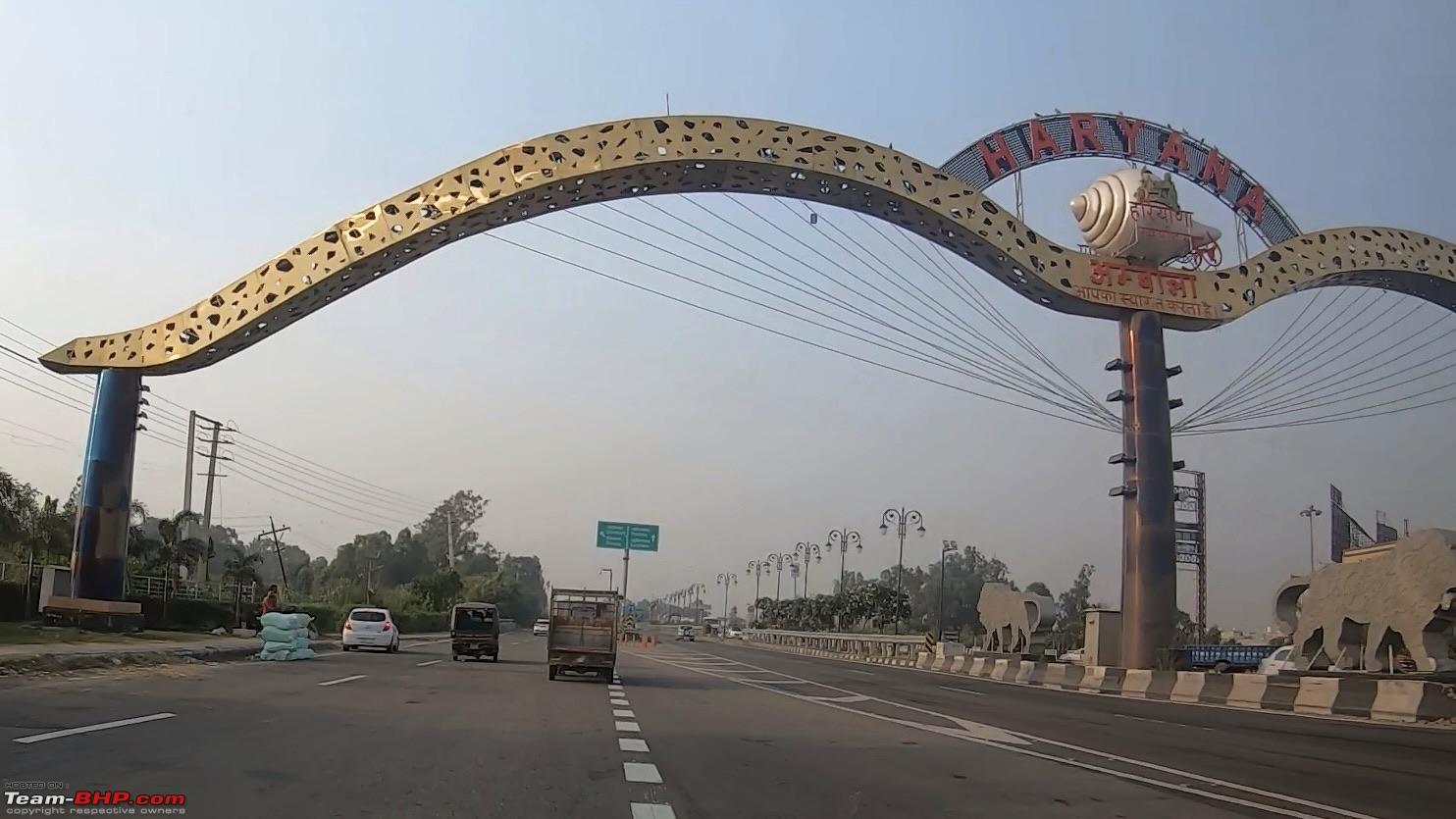 NH44 at Ambala before the turning First view of mountainsAfter crossing Zirakpur and Dera Bassi, we drove under the flyover and then took a right towards Panchkulla. This flyover is a oneway flyover which one can avail while coming from Shimla to Chandigarh only. Crossed Panchkulla at 5:15 pm. Sun was about to set as we reached the first toll of Himalayan expressway (NH5) and soon caught the first glimpse of mountains at a distance. We took a short tea break. Kufri was still 115 km. In the next few days we will be travelling through many districts of Himachal Pradesh - Solan, Shimla, Kinnaur, Lahaul & Spiti, Kullu, Mandi, Bilaspur. Himalayan ExpresswayNewly constructed Himalayan Expressway is an awesome experience to drive on. It has been completed between Chandigarh and Solan. Solan to Shimla is still under construction. Gone are the days of eternal traffic jam in Kalka and Parwanoo. We kept on driving through the winding roads as dusk sets in. We reached Dharampur toll at 6:20 PM. Our plan was to pick up something from Mcdonalds at Kasauli- but somehow missed it and went ahead. Reached Solan just after 7 pm. Lights from across the hills kept on shimmering in darkness as we drove along.  Himalayan Expressway - Welcome to Himachal  Towards Shimla ShimlaWe reached Kandaghat and went past the fork from where road on right goes towards Chail. We initially thought about taking Chail route and stay at Narkanda. But it was narrow and not the best road to drive at night - so we dropped the idea. After crossing Kandaghat, we reached the point from where Shoghi bypass forks at right and G-maps was nudging us to take Shoghi bypass. Ignoring G-maps we drove straight as our plan was to go through Shimla city. At about 8:40 PM, we reached a fork from where NH5 continues as Shimla bypass on the right downwards and the road straight (NH205) goes through Shimla. As it was already night time and this being off season for tourists in Shimla we prefer to go through the city instead of taking the long bypass route crammed with trucks. We continued to drive through the nightscape of Shimla city with sparse crowd and traffic, passing through Cart Road, the tunnel onto Circular road. Reaching KufriFrom circular road, 14 km before Kufri, we took a left turn downwards to Dhalli bypass. We reached our hotel Sterling Kufri at 9:20 PM. It was 9° C in Kufri and soon we started putting on warm clothes. Sterling is located just by the side of highway, has ample parking space and offers an excellent view of the mountains and valley. Day 3 : 14-10-2021 : Kufri to KalpaAdventure beginsAfter breakfast we put the stickers on our car. Both the Trailhawk siblings were looking gorgeous ready to take on any roads. We topped up DEF, windshield washer and started from Kufri at 10:45 AM. Today we will go via Theog-Narkanda-Kumarsain-Rampur-Jeori-Bhabanagar-Tapri-Powari-Reckong Peo and then finally to Kalpa.  A room with a view  View from Kufri  Trailhawk siblings ready for adventure  Drive through apple orchards and pines VLOG for Kufri-Kalpa-Nako NH5 and apple orchardsIt was a lovely sunny morning and a bit warmer too with outside temperature already touching 19℃. Today we will be driving through the magnificent Indo-Tibetan highway which was regarded as the deadliest road till sometime back. This entire stretch of road extends from Shimla to Shipki La near Khab in Indo Tibetan border (erstwhile NH22) though the old alignment was till Kaurik in Sumdo. This is now renamed as NH5. As we drive through NH5, we could see the snow capped mountains at a distance. Kalpa is about 213 km from Kufri at an altitude of 9700 ft. and we expect approximately 6:30-7 hrs to reach Kalpa. Few kms from Kufri is the town of Theog. There is a bifurcation after Naya bazaar where road on right goes towards Rohru and NH5 continues towards left. We could locate the point where a gravel road on left goes down sharply towards Zostel where we planned to stay initially but dropped the idea due to time consuming ingress and egress. On the right there is a sharp hairpin going upwards. Its a clear blue sky and not a drop of cloud in sky - we were enjoying every moment of drive. As we drove along we could see many apple orchards on the slopes of the hill covered with white nets to protect them from hailstorms. We can see crates full of apple being loaded into trucks indicating that apple harvesting season is here and, of course, Kinnaur apples are famous. At about 11:40 AM, we passed Matiana, a small town, known for its apple orchards.  Apple orchards after Matiana NarkandaSoon the landscape of Narkanda started unravelling before us. Both sides of the road are dotted by groves of Pine and Deodar more than ever. We reached Narkanda at 12 noon. Just at the point where NH5 turns left we could see a road going straight towards Hatu peak. We kept on driving on NH5 as snow capped mountains become more and more pronounced. As we cross Narkanda town, the landscape become more and more accentuated with coniferous forest, oaks, maples and the tall pine trees seem to stretch out to the sky, blocking the sunlight. We felt ecstatic driving through such picturesque landscape and winding roads.  Passing through Narkanda SutlejWe went pass Kumarsain at 12:30 PM and started our descent towards the Sutlej valley. After Kingal town, we took a short break and resumed our journey at 1 PM. As we descend through a series of winding loops, we could finally see a greenish Sutlej River on our left at a distance. Soon, we started driving by the right bank of Sutlej. 20 km before Rampur, we came across a hydel power project and encountered some bad roads for the first time. We passed through Nirath village and soon reached Rampur. Rampur is the 2nd most important town in Shimla district and at a much lower altitude than Shimla. We went pass the famous Hanuman statue and then stopped at Cafe Sutlej by HPTDC for lunch at 2 PM.  Break after Kingal  Driving by Sutlej river  The Dog on a bike  Towards Rampur  In front of Cafe Sutlej Post Lunch sessionThough the food was excellent in Sutlej cafe, the service was extremely slow . We started from Rampur at 3:30 pm . Faced some traffic jam as road work was going on. We have plans to top up at the last fuel pump before Kaza at Powari ( about 15 km before reaching Kalpa). But sometimes Powari outlet runs out of fuel early. Hence we topped up fuel from a BP outlet just after crossing Rampur.  View of Sutlej from Rampur The ForecastAs we drove along we started discussing on a news we heard from locals while we were at lunch - there is a snow storm alert between 17th to 19th i.e. the time when we will be in Kaza or in-transit to Mud or Kaza. If the oil tankers cannot come to Kaza due to snow, then our back up plan of 25 L reserve fuel will come handy. At least we would be able to retrace back if the roads are blocked beyond Kaza. Since all these are in realms of possibility, we stopped and continued to enjoy the landscape. Welcome to KinnaurTextured mountains with golden rays of Sun falling on it coupled with picturesque slopes dotted with apple trees and conifers, makes the drive magical. We started encountering some bad patches of road once in a while . Crossed Jhakri at 4 pm and reached Jeori after 20-25 mins. From Jeori a road on right goes towards Sarahan which is famous for Bhimakali temple. After crossing Jeori we encountered a shooting stone area. At 4:40 PM we crossed the welcome arch and entered Kinnaur district leaving Shimla district. Its another 73 km to Kalpa from here. Half-tunnels of NicharAs we entered Kinnaur we are greeted by most scenic roads. As we drive by Nichar, we could see the famous half-tunnels which never cease to astonish the travellers. It is amazing to see the tunnels which were carved out of rocks while building the road many years ago. Throughout this cliffy stretch, the rocks formed a canopy over the winding road and makes it a spectacular drive. The falling droplets from overhanging rocks rolling down the windscreen seem to be symbolic with Trailhawks tears of joy.  Half tunnels of Nichar Sangla and KarchhamWe crossed another bridge and reached Bhabanagar close to 5:25 PM. The entire valley is in shadow now as rays of setting sun is blocked by the high mountains. The valley has now become a bit narrow as we start to descend. We reached Wangtu close to 5:40 PM. There is a proposal to build a road from Wangtu to Kaza thus cutting down time to travel to Spiti and improving overall connectivity. There is a Karcham-Wangtu hydel project of 1000 MW on Baspa river. We did so many criss-cross over the bridges that I was unable to keep count. After crossing Tapri HP Petrol pump, we crossed over the river twice in succession through 2 bailey bridges near Chooling. It was almost dark when we reached Karcham where on the right there is a bridge over Sutlej river which leads to Baspa valley having some most scenic locations of Kinnaur district - Sangla, Rakchham and Chitkul.  Between Wangtu & Tapri Last fuel pump before KazaThe route winds along the Sutlej going upstream along its left bank. We crossed the Sutlej over Shongtong bridge and reached HP Fuel pump in Powari. Though we have fuel, we thought of topping it up. Its already 6:25 PM. But since diesel supply is limited, they are giving a maximum 500 or 1000 rupees worth of diesel to each car. Our tank was almost full and hence that should suffice us. After refuelling we started again. The road now bifurcates left and upwards to Recong Peo, located at an altitude of 7500 ft, the administrative headquarters of Kinnaur district, and NH5 continues along the river. We took the left and drove towards Peo. Further up from Recong Peo is Kalpa (know as Chini village before 1962) and the highest village further up is Roghi which is known for stunning views of the Kinner Kailash peak. En-route Roghi one can visit suicide point which is a vertical cliff extending to a valley. Joining the TeamWe crossed Reckong Peo and reached Kalpa. There were two alternate paths leading upto Hotel Grand Shamba-La at the top our stay for the night. We took the steep narrower one on the left which would be difficult if some vehicle descends from opposite side without looking at dipper. Hence, it is better to take the road on the right. Anyway, we reached our hotel at 7 PM. Grand Shamba-La is a quaint hotel decorated in Tibetan style with comfortable rooms and good food. But the parking is quite problematic unlike some other hotels in this area. We did some catching-up with our friends after dinner and then called it a day. |

|  (22)
Thanks (22)
Thanks
 |
| The following 22 BHPians Thank brownianmotion for this useful post: | //M, AdityaDeane, bj96, BlackPearl, CEF_Beasts, chautob0t, dailydriver, Dwaipayan26, Evyas, GTO, g_sanjib, Mustang Sammy, Pink Floyd, REN, Rookie_Jeeper, Samba, sougatadas, Thermodynamics, Turbanator, unknownartist01, vredesbyrd, yogiii |
| |
|
30th January 2022, 01:02
| #2 |
| BHPian Join Date: Dec 2019 Location: Kolkata
Posts: 56
Thanked: 328 Times
| Jeepers' tryst with Spiti Valley Day 4 : 15-10-2021 : Kalpa-Ropa Valley-NakoA lazy morning at KalpaThe next day we woke up late, knowing that we would not start till our sixth team member is near Kalpa. Kalpa is at an altitude of 9700 ft. and is famous for its apple orchards and the view of Kinner Kailash. We enjoyed the view of snow-capped mountains from our balcony. After breakfast we roamed around a bit. It was a bright sunny day. The snow-capped mountains were visible from everywhere, even the parking space. There were apple orchards in front of the hotel. This is almost the end of harvesting season in Kinnaur.  At our hotel in Kalpa VLOG for Kalpa to Nako Kinner KailashWe started from our hotel in Kalpa at 12 noon. First thing we have to do is to re-fuel from Reckong Peo or Powari. By that time, our friend would also arrive and together we would start for Ropa valley and then on to Nako. As we drove down from Kalpa through a winding road amidst groves of pine and cedar, we can see snow-capped Kinner Kailash standing tall in clear blue sky. Yesterday we missed the scenic view of this entire stretch of uphill road towards Kalpa from Reckong Peo as it was already dark.  Trailhawk coming down from Kalpa Late startThere was no diesel available at IOCL fuel pump in Peo. So our only option is Powari - the last fuel pump before Kaza on NH5. We reached Powari before 1 PM and found a modest queue. Eventually we refuelled and our friend also arrived after some delay. As we were quite late, I was not sure how much we will be able to explore in Ropa Valley. Nevertheless, we carried on with our plan and started at 1:50 PM. A road revolutionFrom Powari, the left turn towards Ropa Valley is about 47 km. Soon after, we crossed the bifurcation from where the left road goes up towards Kalpa and the right road goes towards Nako and Pooh. Nako is 86 km and Pooh 56 km from this point. It is a bright, sunny and crystal clear day with azure sky. As we drive towards Nako, Sutlej River accompanied us on our right side. 9-10 km from Powari we crossed a bailey bridge near HPPCL Kashang hydroelectric project with a narrow stream of waterfall on our left. I think this may be the Pangi nullah but nowhere near its ferocious nature. There is a new bridge also constructed by its side which has not yet been inaugurated. Mountains on both sides dotted with green groves, mighty Sutlej River piercing through the valley and a clear blue sky donning the background its a perfect setting . And roads are just mind boggling . I could not imagine how BRO has turned the most treacherous road into such an amazing tarmac. Road widening has been done by cutting rocks on both sides. We can see rocky overhangs acting like a canopy on the road as we drive.  Road towards Spillo Tragedy of KhaironSlowly the landscape was becoming less green compared to what we have seen yesterday while travelling from Kufri to Kalpa . Also, we can see a snow-capped peak at a distance. 19 km from Spillo we crossed the colourful Khairon bridge. The memorial stone, just before entering the bridge, reminds us of its tragic past. In 2005, when officials came to inspect this bridge , then all on a sudden water level rose abruptly and swept away this bridge along with many officials and workers. Names of all those, who lost their lives, are embossed here. SpilloAfter crossing Khairon bridge, we started to drive along right bank of Spiti river. At 2:10 PM we stopped for lunch at a Punjabi dhaba near Skibba, 17 km from Powari. But unlike a regular dhaba, food preparation and service were very slow. We were getting anxious as we are getting late. We finished lunch at 3:30 and started again. We crossed Sutlej River once again over Akpa bridge and started driving along left bank of Sutlej. Akpa bridge looks awesome with vibrant colours and mountains in background. Previously there used to be a wooden bridge here. After crossing Jangi we crossed recently inaugurated Kiran Khud bridge. We reached Spillo near about 4 PM. Spillo is a major town and earlier mobile network was not available or intermittently available beyond Spillo. Another 13 km from here we have to take a left to Ropa Valley. Just after crossing Spillo we encountered a shooting stone area. Though chances of falling rocks are less in October but still we need to be vigilant. Thats why people were manning the area and only allowing the vehicles to move if it was absolutely safe. We encountered a mini traffic jam due to a military convoy ahead of us. Now the terrain has become much more barren and rocky.  Lunch halt near Skibba  Gorgeous AKPA bridge The desolate Ropa ValleyWe reached the confluence of Sutlej and Ropa River, which is a tributary of Sutlej, and NH5 took a left turn along Ropa River leaving Spiti River behind. Some refer to Ropa River as Syaso Khad - not sure which one is correct. Then we cross a small bridge over Ropa River and reached a T-junction - the left road goes towards Ropa Valley and NH5 goes towards Pooh on right. We took a left towards Ropa Valley and parked our car for a short break so that all cars can catch up and start together. Ropa valley is located at an elevation of 9800 ft along the Ropa River flanked by steep barren mountains on both sides. The main villages of Ropa Valley are - Sunnam, Giabong, Ropa, Talling, Ruskulang and Syaso. The area is surrounded by Chilgoza Pine. Ropa valley is also famous for shawl-weavers, apple orchards, and metal artisans. Houses here are made up of stones with wooden blocks in between. We started towards Ropa at 4:30 PM. Ropa river continues to flow left of us through a gorge. Road condition is good. Giabong is 13 km and Ropa is 16 km from NH 5 junction. After 5 minutes, we saw a switchback on our right going upwards towards Syaso village. White Ropa River hurrying through the narrow gorge anchored by steep mountain facades on both sides looks awesome. Rock patterns here are different from that of other parts it seems like slabs of different rocks with flat surfaces moulded together to form the mountains. There is no net or phone connectivity here. Gradually the gorge widens to a narrow valley and soon we reach a bridge. After crossing the bridge, we reached Sunnam village. After driving for a minute or two from Sunnam village we saw a Y-fork and the road on left side is going down towards Ruskulang village on the bank of Ropa River. Soon after we reach a point where the road towards left goes to Giabong. There are apple and apricot orchards in Giabong. An army station is also there in Giabong. In the interest of time, we drove forward and crossed another bridge over a rivulet. After few minutes of driving we found an army station. Crossed the army station and reached Ropa village. Ropa village has a population of 300-400 and houses a 1000 year old monastery. You will get homestay in Giabong but not in Ropa. One can trek to many important locations of Spiti from here including Manirang peak. We spent some time there, had some photos and decided to return. As it was getting late, we did not venture out in the river bed.  Near Giabong  Ropa Valley  View of Ruskulang village Pooh - Nothing to do with WinnieWe started our return journey at 5:30 PM and reached NH5 junction at 6:10 PM. By now it is completely dark. From here Nako is another 48 km. Fork towards Pooh on NH5 is another 13 km. Pooh is located at an altitude of 8700 ft and is an important town. It is actually a 3 km uphill detour from NH5. We passed by Pooh at 6:27 PM. This is the same village we tried to visit on 2009 but had to turn back due to a road closure. Khab bridge and Spiti riverAbout 2-3 km before reaching Khab bridge, we can barely notice in cars headlight, the Y-Fork where NH5 goes upward on the right side to Namgia and further to Shipki La Pass that connects India with Tibet. The straight road is now NH 505. Soon, we crossed Khab bridge which is the confluence of Sutlej and Spiti. From here the Sutlej goes towards Tibet and the road climbs uphill towards Nako with Spiti River flowing through the deep gorge on left. It was dark and hence we did not stop and planned to come here tomorrow before going to Tabo. The road surface was buttery smooth as it climbs rapidly through a series of hairpin bends or Kazigs as they are called. A night in Hangrang ValleyFinally at 7:15 PM we reached our camp Knaygoh Kinner Camps through narrow alleys of Nako town. Parking at Knaygoh Kinner Camps was quite an affair. But the picturesque camps were a welcome sight after a tiring day. The camp is named after the original name of Nako, which is Knaygoh. These are spacious Swiss tents with attached bath. There was a small garden in front of the tents and at the centre of it there was an open sit-out area with log-fire. Another tented sit-out area was provisioned nearby for those who do not want to sit in open. Altogether, it was the perfect setting for a party. So we had a small evening bash in the chilling cold of Hangrang valley with excellent food and a lot of adda. Day 5 : 16-10-2021 : Nako to Tabo via Khab Bridge and Gue villageAbout Nako villageNako is a small village, located around sacred Nako Lake, at an elevation of 12000ft , in the Pooh sub-division of Kinnaur district of Himachal Pradesh. Technically a part of Kinnaur district, Nako is located near the border of Spiti and Kinnaur district and actually is a part of Hangrang Valley. Some other villages in Hangrang valley include Chango, Leo, Hango, Shalkar, Ka, Sumra, Yangthang and Malling. Though located in Kinnaur, topography of Nako is that of a cold desert in rain-shadow zone and resembles more of Spiti than Kinnaur. In fact, even being a small village of about 400-500 population, Nako is the largest village in Hangrang Valley. Nako has a rich history and famous for Nako Lake, Nako monastery and many stories related to Tibetan guru Padmasambhava. VLOG for Nako to Tabo via Khab bridge and Gue Good morning from NakoWe woke up at Kinner camps, Nako just before 7 O clock in the morning and came outside our tent. The tent was so cosy and the bed so comfortable that we slept like logs. Outside it was chilly and peaceful. Temperature was around 5° C. Last night it had dropped to -7°C. What we couldnt see last night was how beautifully the camps were located amidst surrounding mountains. The tents are aligned on a semi-circle facing the valley and Nako Lake. From the higher grounds of our camps, we could see Nako village and a small portion of Nako Lake down below. It is indeed one of the most picturesque campsites in Himachal. Because Nako is at an altitude of 12,000 ft, few were complaining of headache which may be a symptom of altitude sickness. The cool breeze and tranquil atmosphere refreshed us. We got ready, packed our bags and then went to the dining area for breakfast. The dining area is quite spacious and beautifully decorated with thangkhas and pictures of Spiti valley hanging from stone walls. After a hearty breakfast with bread, eggs, fruits and beverages, we are all set to start our journey.  View of Nako village and Nako Lake from Campsite  Kinner camps at Nako Leaving NakoToday instead of going to Tabo, first we will take a de-tour and go to Khab bridge, retracing our path from yesterday. Yesterday, it was dark when we crossed Khab bridge (confluence of Sutlej and Spiti River) and Dabling bridge (over Sutlej River just after Pooh) and missed the entire view. Hence we are going back today till Khab. In the interest of time, we decided not to visit Nako Lake or Nako monastery. We started at about 10:10 AM. From Khab bridge we will go to Tabo. On the way to Tabo, we will again take a detour after Sumdo to visit Gue Mummy Temple. And I think to myself what a wonderful road it isWe went past the gate of Nako village and took a left turn along NH 505 going downwards. As the road spirals downward, the view of craggy mountains of barren cold desert accompanied by deep valley and a serpentine black top road with a boundless azure sky in background looks out of the world. Roads are terrific perhaps the best and the traffic is sparse. This stretch of erstwhile Indo-Tibetan highway is simply gorgeous. And we are enjoying every moment of it. Temperature outside is about 19°C but the sun is so bright and scorching that it felt like much more. At 10:35 AM, after about 12 km from Nako we reached a point where a newly constructed link road goes towards right to Hango and Cholling village. This is called Leo link road. Hangrang valley is much more desolate and beautiful. Once Hangrang Valley will be well connected then it would become another tourism destination equivalent to Spiti. After another 10 minutes we can see a refreshing patch of green along the slopes of rocky mountains. This is Ka village a very small village with a population of 30 located 21 km from Pooh. People in Ka village relies mostly on farming. We can see few small dhabas and a BRO camp here.  Link road to Hango and Cholling  Road approaching Khab The KazigsOnce we went past Ka village, we can see the snow-laden peak on our right. That may be Reo Purgyil- the highest peak in Himachal Pradesh. After passing Ka, a series of hair pins, like a crawling snake, descends all the way to Khab bridge. Vistas keep on changing as you descend through each of these loops. These loops are also known as Ka loops or Kazigs and makes you descend or ascend almost 3000 ft between Khab bridge and Nako.  Trailhawk siblings having fun time in Kazigs Khab bridgeAs we descend towards Khab bridge through picturesque roads with overhanging rocks, we can see the narrow Spiti River down below for the first time. We reached Khab bridge at 11 AM. Throughout the road we can see BRO personnel working to keep this road safe and in proper condition. Hats off to BRO for building such a wonderful road in such a difficult terrain. The bridge is situated at the confluence of Spiti and Sutlej rivers amidst towering mountains on all sides. It is so stunning in its appearance that it takes your breath away. Its popularity can be easily gauged by the photo shoot which was going on when we reached the bridge. We crossed the bridge and parked our car on the other side. As we were crossing the bridge, on our left we saw the peak of a snow-capped mountain through the gap between two mountains on both sides. That seems to be Reo Purgyil, which is situated at the Tibetan border. A narrow trail forked downwards from NH 505 on our left. We walked down the trail towards the river banks. The mighty Sutlej seems to be rushing towards the Tibetan border with an awe-inspiring roar carrying calm Spiti river in its fold. Colours of muddy-brown Sutlej and a deep blue Spiti River, can be clearly delineated at the confluence. There was also a dhaba nearby to serve motley group of tourists visiting the area. We walked up to the bridge, took some photos and then started on our way back towards Nako.  Khab bridge  The confluence of Sutlej and Spiti  Trailhawk at Khab bridge Retracing to NakoWe started our journey from Khab bridge towards Tabo at 11:40 AM. From now on, we will have Spiti River on our left. As we started ascending, the view becomes all the more amazing with rays of Sun falling directly on the slopes of barren and rocky mountain. We ascended through Kazigs and soon reached Nako at 12:30 PM. Gue is another 47 km from Nako. As we drove past Nako, we can see Nako monastery perched on top of a hill. We kept on driving on NH 505 towards Malling. Malling NullahAfter crossing Malling village we drove towards Malling Nullah. Situated at an altitude of 12,700 ft. Malling Nullah is an infamous stretch of dreadful road extremely prone to land slides, shooting stones and, of course, gushing water crossings. In its full flow, Malling Nullah can send shivers through the spine of most adventurous soul. However, now its just a shadow of its past as BRO has done impressive work in channelizing the water flow, containing the landslides by reinforced structures, maintaining roads in proper shape and keep them free from any debris or falling boulders. We can see lots of BRO persons working in this area. Also we saw a small temple on our left, just before entering the Malling Nullah zone no wonder why ! As this is the month of October, anyway water flow was minimal and we crossed easily. Narrow gravel road with rocky mountain on one side and switchbacks and sharp bends hugging the valley on the other makes for an exhilarating yet dangerous drive. One wrong move and you are gone. Even though Malling Nullah has lost its veracity, this stretch of the road even now is the most notorious part in the entire route to Spiti.  The actual Malling nullah crossing which is now so easy  Dangerous roads of Malling nullah Descent from MallingAs we make our way through the winding roads, the rugged view of barren rocky mountains with moonland pattern and deep valley feels us with an awe. Now Spiti River is faintly visible from time to time that too, like a thread way down below. On the way, we saw some dumpers collecting landslide stones and some JCBs clearing of the debris. Few shades formed on barren mountains by cloud covers keeps on shifting perennially. As far the eye goes, the landscape is accentuated with different kinds of rock formations and various shades of lights making a surreal atmosphere. After 1-2 kms the road starts to descend steadily towards Chango village over buttery-yellow ridges in a series of switchbacks. As we go down, Spiti River becomes more and more visible.  Trailhawk descending from Malling nullah towards Chango ChangoFinally at about 1:20 PM we completed our descent and have Spiti River right before us. From this point the road towards left is sort of a dead end. We took right towards Chango with Spiti River flowing on our left. Then we crossed a bailey bridge and reached Chango at 1:30 PM. Chango is the biggest village of Hangrang Valley and known for its good quality apples. It is situated at an altitude of 10,000 ft. Chango is also famous for its nunnery. By mistake, we drove inside Chango village towards the nunnery but soon realised our mistake and turned back. We dont have time to visit the nunnery - so we carried on towards Sumdo which is 13 km from here. Sumdo - Entry to Lahaul & SpitiAfter driving another 3-4 km, there was a bridge over Spiti River which we crossed and went to the other side. From now on, we have Spiti River on our left. In another few minutes we reached another village - Shalkar. At 2 PM, we crossed the bridge over Spiti River and entered Sumdo located at an altitude of 10,200 ft. Sumdo is the administrative entrance to Lahaul & Spiti district and the confluence of Spiti and Parchu River. When we crossed the bridge, we can see the confluence diagonally on our right. Parchu river originates from Parang La, flows east to Tibet and again winds back to enter India to join Spiti River in Sumdo.  Sumdo - Confluence of Parchu and Spiti Spiti ValleyWe have to make an entry of the vehicle and the passengers at the Police Check post in Sumdo. Finally we have reached Spiti. As we crossed the check-post, a board says Welcome to Spiti Valley. All of us are overjoyed. We parked our cars and had some pictures taken. We had a samosa lunch in a shop just after the check-post and started after 15 minutes. 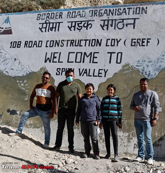 Entered Spiti Valley Woh China Jaata HaiAs we started, we came across a Y-fork. The road straight goes towards Gue. But I was curious about the road which goes uphill and inquired with a local. He told me woh China jaata hai. That made me even more curious. Then I came to know that this road goes towards Kaurik and Lepcha villages which are on Indo-Tibetan border and falls under restricted zone. Kaurik village is now uninhabited after an earthquake many years back. The Tibetan Mummy3 kms after Sumdo, at about 2:30 PM we reached the point where a detour on right goes towards Gue village. Gue is a tiny hamlet near the Indo-China border at an altitude of 10,500 ft. The entry to the road is adorned by a colourful arch with Welcome to Gue and Tibetan hymns embossed in it. From here, its an 11 km drive along a narrow road abutting the mountains. We took a right turn and continued to drive along with Gue nullah flowing through a gorge on our right. Road condition is quite good. Gradually, the narrow gorge opens up to a wide valley . After a 10 minute drive we started to gain height through winding roads. As more and more greenery started to appear in the valley, the landscape looked awesome with green meadow surrounded by barren rocky mountains. We reached a valley with abundant vegetation and a lush fall colour with houses dotting its periphery. This is Gue village. Gue is an extremely pretty village with whitewashed house made of mud and stone, clean roads and well decorated facades. We can see haystacks in almost every house. Gue is surrounded by mountains on all sides. It barely comprises of 30-40 houses. Nowadays there are home-stays available as well. Gue gompa is located at the end of the village on a hilltop overlooking the village. We passed through the village road cordoned with stone walls on both sides, drove up to the hilltop and reached the temple at 3 PM. We were surprised to see the mummy as it was not akin to our conventional idea of an Egyptian mummy wrapped with white bandages all around. This mummy was kept in a glass box in a one room temple and is seated with his mouth open, his teeth visible, and hollow eyes. It is believed that Gue mummy is naturally preserved, not wrapped in anything and has eyes, teeth, hair intact. Gue mummy is believed to be of a Buddhist monk, Sangha Tenzin, and it dates back to 1430 AD. This mummy was discovered by the Indo-Tibetan border force while digging up their bunker in 1981. Age of this mummy was ascertained in 2002 by a Californian scientist through carbon dating. This mummy is supposed to have undergone natural mummification. And most surprising part is that the mummy is in same posture since 1430 without any preservation. Now a new monastery has also been built adjacent to the small mummy temple. We spent some time enjoying the wonderful landscape and started our journey again at 3:30 PM.  Village road towards Gue Mummy temple  Gue Mummy Temple  The Gue Mummy  Jeepers at Gue Hurling villageAt 4 PM, we reached the arch from where we turned right towards Gue village. Tabo is another 25 km from here. We continued to drive along the right bank of Spiti River. Sun has now tilted west. Sometimes the glittering rays of Sun was directly reflected by Spiti River to our eyes. After 10 minutes we reached Hurling village. Hurling village was mainly formed by households uprooted from Indo-Tibetan border villages in 1962 war with China. Today its a prosperous village looking to seal its own place in Spitis political, social and economic landscape. Tabo is 20 km from here. Off-roadingCrossed Hurling and continued to drive through the valley washed out with sun rays. The convoy of Jeeps are moving in tandem with each other. Road condition suddenly deteriorated a bit while passing near a village Sumra. The sun has now hidden itself behind the mountains and the valley is fully in the shadow even though sun is shining bright. We can see sunlight on higher slopes of the mountains. We passed an area where Spiti river has meandered and given rise to green plantation on its basin. We crossed a point where we can see a suspension footbridge below. It was nearly 5 PM when we spotted a steep gravel road going downwards from the main road towards river basin . As Tabo is near, we decided to take our car to the river basin and have some fun. I felt happy that I would be able to use 4 WD and try some things, like Hill descent control, which usually we do not get much opportunities to use. So we went down to the river basin, had some fun, went up to the river and then came back on road. For Trailhawk it was an easy ride. Its 5:40 PM when we started our journey and the sun has almost set. After 5 minutes we passed through Lari village which is the last village before Tabo. Spiti River has now moved far away and we have Lari High School on our left - what a picturesque location for a school !!! I have heard that 3500 years old rock carvings can be found in Lari . Also Lari village has a monastery which can be trekked if you follow the narrow road along the tributary of Spiti river on the right .  Spiti Valley near Tabo  Picturesque Spiti river bank near Tabo  Team Jeep at Spiti river bed near Tabo  Team Jeep en-route Tabo  Trailhawk on its way up from river bed Night in the monastery townAfter Lari, Spiti river moved further away, as the landscape opened up with stretched out valleys anchored by mountains at a distance. Its 6 PM when we reached the arch welcoming to Tabo and took a left turn towards Tabo monastery. Soon we reached our halt for today - Hotel Maitreya Regency. The location of the hotel is very good, only about 200-300 metres from Tabo monastery, which is an easy walk. And the hotel balcony has a good view. The hotel has a nice open sit-out area in front where we can sit and chat for eternity. We had a relaxing evening in the hotel. After dinner, a fellow from the hotel took us on a walking tour to the nearby helipad, which was a short walk away from the hotel and an excellent place for star-gazing. This was an amazing experience. It was pitch dark and we couldnt even see ourselves. Looking up we saw the sky was glittering with millions of stars. We are not very knowledgeable about constellations but we could recognise a very well-known cluster : Orion-the Hunter. There were other formations which seemed familiar but we couldnt identify them. It was almost 10:30 pm and getting very cold in the open airfield. So we started walking back to our hotel. Our first night in the Spiti valley was a memorable one. |
|
| (24)
Thanks
|
| The following 24 BHPians Thank brownianmotion for this useful post: | //M, 2himanshu, AdityaDeane, ampere, BlackPearl, CEF_Beasts, chautob0t, GTO, g_sanjib, lapis_lazuli, MSAneesh, Pink Floyd, PM - B, Potenza, REN, Rookie_Jeeper, Samba, Sujoy76, Thermodynamics, unknownartist01, vredesbyrd, yogiii, ysjoy, zurura023 |
|
30th January 2022, 01:22
| #3 |
| BHPian Join Date: Dec 2019 Location: Kolkata
Posts: 56
Thanked: 328 Times
| Jeepers' tryst with Spiti Valley Day 6 : 17-10-2021 : Tabo to MudWaking up at TaboAs we were having our morning kappa, enjoying the mountain view from balcony of our room in Hotel Maitreya Regency, the overcast sky started to ring some alarm bells. Forecast of snow has been confirmed by the guy at reception and also by one of our friends in Kaza. On one hand, I am getting adrenaline bump with prospect of snow drive but on the other hand, a fear of uncertainty over the remaining trip looms large. Anyway, we stopped worrying and decided to take things as they come. VLOG for Tabo to Mud (Pin Valley) and from Mud to Kaza Apples of TaboTabo is known for the best quality of apples in India - especially the golden apple. It is also known for its apricots. This is the apple harvesting season in Tabo as we can see apples being packed into crates. The colder environment in Tabo, compared to other parts of Himachal, and a fertile Spiti valley ensures that the apples take 1-2 months more ripening time than other apple orchards of Himachal. Though I am not a great connoisseur of apples, the joy of biting a fresh apple plucked from an apple tree is something else. Some of us purchased apples from Tabo market near the monastery. Then we had breakfast in hotel and went to see Tabo monastery.  Apple orchards of Tabo The MonasteryTabo monastery is a 1000 year old monastery belonging to Gelugpa sect and considered one of the holiest monastery in Himalayas and India. Unlike most other Buddhist monasteries, Tabo monastery is located in the valley rather than on top of a hill. Its a Unesco world heritage site as well. There are caves curved into the cliff which were used by monks for meditation. Because of its frescoes and stucco paintings inside the cave, Tabo monastery is often referred to as Ajanta of the Himalayas. The beige buildings in the monastery looks like sandcastles prepared by some sand artist. Main temple has an entry hall followed by an assembly hall. We have to duck to enter the main temple and its so dark inside that our eyes take some time to adjust. The hall is lit by a beam of natural light streaming in through the sky window. But even in that faint light we were amazed to see the murals on the walls, the thankhas, the inscriptions and wall texts representing a bygone era. There are 32 life-size clay sculptures embedded in the wall. We came out of the main hall, went to other parts and clicked some pictures. Also, we saw the new monastery that has been built adjacent to the old monastery. There is provision to stay in monastery guest house albeit it has very basic facilities only. I was keen to visit the monastery cafeteria which serves out some lip smacking food - but due to lack of time could not do so.  Tabo Monastery  Inside Tabo Monastery site  The Main Hall Starting for Mud (Pin Valley)We topped up DEF and poured remaining diesel from jerry can. Its 11:45 AM as the sky was becoming more and more overcast. We started from Tabo and soon crossed the landmark Tabo bridge over Spiti river. Our destination is Mud village in Pin Valley. Mud village is situated at an altitude of 12,500 ft in Pin Valley. Distance between Tabo and Mud village is 65 km. The winding road from Tabo, runs by sleepy hamlets of Spiti following the deep blue Spiti river, on our left, making its way through a braided river basin. 4 km from Tabo, we passed Kurith village which has a population of 30 only. The view was simply spectacular with clouds rolling down the mountain slopes and a deep blue Spiti river flowing through the valley anchored by mountains on both sides. While passing through small villages, we can see a feast of fall colours by both sides of the road. After crossing Poh village, the landscape opened up dramatically and the narrow valley turned into a vast expanse of wide flat arid region surrounded by mountains at a distance and the tarmac road running gracefully through the valley. Momentarily we got a feeling of Ladakh in Spiti. We could see some awesome rock formations on both sides which is quintessentially Spitian. Soon the valley narrowed down and we could see Spiti river once again. However, now Spiti river bears the look of a gorge as it flows through. At this point we can see first drops of rain landing on the windshield.  Picturesque rugged landscape with Spiti river en-route Attargo from Tabo Reaching Attargo bridge17 km from Tabo we reached Mane bridge on left. This bridge goes towards Mane village which is 6 km away. Mane is another quaint hamlet in Spiti having some home stays. Gradually, few scanty drops turned into a light drizzle. We passed through Shichling village which looks to be quite a prosperous village with pukka houses unlike other small villages. Little after 12:30 PM, we reached a point where the road forks out to Dhankar monastery on right. We have plans to visit Dhankar monastery tomorrow en-route Kaza from Mud. After crossing Dhankar, the river basin becomes wide and flat. This is the confluence of Pin and Spiti river. However, the river basin is so braided and flat with criss-crossing rivulets, one could hardly distinguish between Pin and Spiti river. We can see the roads on the opposite side at a distance on the left bank of Spiti river. Thats the road we will be taking as we go towards Pin Valley. We crossed Lingti bridge and went pass Lingti village - the last village before we turn towards Pin Valley . 2 km from Lingti, we reached Attargo bridge near about 1 PM. This is a loverly colourful bridge over Spiti river which connects Pin Valley to Spiti Valley. From this point Mud village is another 34 km on left and Kaza is 16 km straight.  Bridge towards Mane village  Attargo bridge Entering Pin Valley National ParkWe turned left from Attargo bridge and started driving on the right bank of Spiti River. On the opposite bank, we can see the road by which we came and also the layered rock formations. Soon we entered into Pin Valley national park. We expected to get gravel road throughout the entire stretch but to our pleasant surprise, after first 200-300m we found good tarmac road. We reached the confluence of Pin and Spiti River , but this time on the Pin Valley side, and turned right leaving Spiti River behind . From now on we have Pin River on our left. As we drove through the Pin Valley, the landscape looked awesome with a turquoise Pin River running like a ribbon through the valley down below, the fall coloured vegetation dotting the banks of Pin River, mountains on both sides reaching out to skies even as the deep valley keeps them grounded and as if a black tarmac road has been painted through the middle of the valley. Pin Valley is home to many flora and fauna including some endangered species like Siberian fox, Himalayan Ibex and the most elusive of them - Himalayan snow leopard . Hence its ecological importance is immense.  View of rock formation on opposite bank of Spiti River  Pin Valley Villages of Pin ValleyBut the good roads did not last forever. After some time it becomes a combination of gravel roads and roads with broken tarmac. We are about 23 km from Mud, when the drizzle becomes a bit heavy and the outside temperature is showing as 5°C . The lush fall colour of Pin Valley landscape makes you feel as if it is straight out of Van Goghs canvas. Pin valley comprises a cluster of 17-18 villages which has a total population of about 1500-2000. Most of the locals follow Tibetan Buddhism as religion. Reached Gulling village at about 1:40 PM. This is one of the biggest and important villages in the area. We could see many dhabas and Homestay as we drove through Gulling village. After passing through Gulling, we took a left and crossed a small bridge. About 400-500m after that bridge, we reached a point from where a road forks upwards to the right towards Kungri monastery. Kungri monastery is the second oldest monastery in Spiti. Had we started earlier and had the weather been on our side, we would have certainly visited Kungri monastery.  Gulling village First view of Parvati rangeAs we drive along, we reached a small meandering section of the road. Just at the end of that section as we are emerging through two giant rock formation on both sides, all on a sudden, almost from nowhere, the entire Parvati range appeared before us. We were completely spellbound by the view of misty, snow-capped Parvati range standing tall piercing through the clouds above. The village at a distance with houses painted white on the exterior and the lush green trees boasting of fall colours in the background of a majestic Parvati range was a sight to behold. No wonder Mud village is the end or start point for Bhaba pass and Pin Parvati treks.  Parvatii range Crossing Pin river towards SagnamWe passed through Mikkim village which has a population of 30 and then reached a point from where a road forks out upwards to the right towards Phukchung village. This is again a lovely hamlet where you can unwind and lose yourself in the lap of nature. Beyond Phukchung there is the last village of Pin Valley - Kaa village. But, we did not have time to include so many nice places and hence we drove forward hoping to come back again. Reached Sagnam bridge at about 2 PM. Sagnam bridge is a beautiful long bridge over Pin River draped in all green hues. We crossed Sagnam bridge and turned right towards Sagnam village which is the largest village in Pin Valley. Mud is about 13 km from this point.  Sagnam bridge over Pin river October SnowWe took a short break after crossed Takshan village and started again. It was a wonderful spectacle witnessing 6 Jeeps rolling through the mountain roads with such rhythm and eloquence. The drizzle continued as the landscape became misty and sky got completely covered with clouds. At 2:30 PM we reached a place Tailing where there is a beautiful suspension footbridge. We were eager to take a walk over the bridge and go to the other side but since its already late and we are damn hungry we decided to carry on. Soon after crossing Tailing, we started to get the first snow in this trip. Though its not too heavy but we need to hurry up as other Jeepers need to go back to Dhankar. In a way, the forecast has become a reality. Reaching Mud villageWe entered Mud village at 2:40 PM . By now snowfall has increased a bit. We parked our cars and immediately went to Tara Cafe for lunch. We wanted to have local pizza , a speciality of Tara Cafe, for lunch. But since it will take time, we settled for our staple Himalayan diet of Maggi and Omelette. We had our lunch in a well decorated and cozy room heated by Bukhari. By the time, we completed our late lunch, the snowfall has increased and Trailhawk is enjoying its first snow bath. When shall we meet again - in thunder, lightning or rainAs we came outside after lunch, we can see that tourist vehicles are hustling to leave in fear of getting stuck by snow. Its time to bid goodbye to rest of the team as they started their return journey towards Dhankar. We will be joining them tomorrow at Dhankar - but tomorrow now seems to be quite far away. With all tourists gone, this tiny hamlet fell into a deafening silence punctuated only by murmur of falling snow, as we continue to laze around, soaking in the tranquility of the moment and staring spellbound towards a mystic Pin Valley. Night halt at MudTonight we are staying in Tara Homestay - we met Kunzan ji and Sonam ji who run this home stay and are extremely helpful. We can get an excellent view from the terrace of Tara Homestay - but now its getting dark and also the stair to terrace has become slippery due to rain and snow. So we decided to go to the terrace the next day. Our room in Tara Homestay is as warm and cozy as a room can be. The window has a view of the Pin Valley and the room is very well maintained and well decorated. We had our dinner with the local pizza it was awesome. The snow has stopped by now. But Kunzan ji told that its most likely to start again and may continue throughout the night . It was -2°C at 8:30 PM . Not worrying about what the tomorrow will be, we called it a day.  Tara Homestay - our night halt Day 7 : 18-10-21 : Mud to KazaA white Pin ValleyIt is a cold, snowy and overcast morning as we wake up in our lovely cosy room with a view at Tara Homestay. Its been snowing continuously throughout the night . Last night it was somewhere -8°C but we did not feel it as the room was so warm and cosy. The view of the white Pin Valley from the terrace of Tara Homestay looks enchanting and out of the world. Entire village is covered in a blanket of snow. I was a bit worried whether Trailhawk will start smoothly or not. But voila! It started in one crank. No issues at all . Kept it started for some time and went on to have breakfast with peaceful mind. Today we need to start as early as possible.  Trailhawk in overnight snow - half cleaned Checking on road conditionsWe had our breakfast in Tara Cafe. We are delighted see warm pizzas ready and packed for us. After breakfast we started checking about road conditions and whether any road has been blocked due to overnight snowfall. Due to higher altitude, Mud gets more snowfall than Kaza and hence we may expect lesser snowfall as we go down . We also learnt from locals, that its unlikely that Kunzum pass will open as it will have much more snow. Of course, that information made us a little dejected but looking at the brighter side - who would have expected we will get to drive through a snow covered Pin Valley in October - we got rejuvenated. Kunzan ji also told that as we have 4x4 we wont have any issues in driving through the snow. In fact, Sonam ji is also going towards Sagnam with his Bolero camper 4x4. He asked me not to worry at all. Preparation for snow driveNow the most important thing is to clean up our car. Thankfully, I put the windshield cover which made my job easier as I dont have to scrape ice from the windshield. Checked tyres and tyre pressure. Locals told us that we can expect to get heavy snow upto Sagnam after which it will be moderate. Today our plan was to go to Dhankar , visit Dhankar monastery, rejoin our team and drive down to Kaza. However, given the current conditions and continuous snowfall, we know that all those plans may be a wishful thinking only. We decided that after reaching Attargo bridge we will call up our team and then decide whether to go to Dhankar or go to Kaza directly . Starting from Mud villageEverything seems to be in place, as we started our journey at 8:30 AM through a sleepy Mud village covered in a thick blanket of snow. Though there was no car in front, we are lucky to spot a tyre track ahead of us. As we drive along, we find everything has turned white with thick snow. It was not even 24 hours that we came through the same road and now we could barely recognise it. Also it had become all the more difficult to spot any rocks or small boulders covered in snow. But I was more worried about falling stones and potential black ice patches. However, Trailhawk seems to be rock steady in snow and drive was as smooth as it gets.  Starting from Mud village  Trailhawk enjoying the adventure Snow drive through Pin ValleyOn our right we can see a white Pin Valley with a narrow Pin River making way through its frozen banks. The valley is hardly recognisable from what it was yesterday. As we move forward, we can see the Bolero Camper driven by Sonam ji in front of us. We kept on driving very slowly on thick snow relying mostly on engine braking. Indeed this is a unique experience and we were cherishing every moment of it. Usually its very unlikely to get snow in October and hence we were pleasantly surprised. Locals told that it might snow entire day today and it might be cold and sunny tomorrow. However, whether that will be good enough to carry on with our trip as per original plan - only time can tell. All the trees boasting of their fall colours yesterday suddenly have gone silent under the blanket of white snow. We descended closer to the Pin River and then again started to ascend. At 9 AM we stopped at a relatively safe position to come out of car and enjoy the snow. We started again and reached the suspension foot bridge over Pin River at Tailing. With snow-capped mountains on one side, rock formations and Pin Valley on the other, we cant help admiring mother nature and its unpredictability. The terrain looked scary but the landscape is simply magical. However, we kept our focus and kept on dodging rocks and small boulders which has fallen from the mountains either last night or recently. Only good thing is that so far visibility is not much of a problem. But we had to use defrost number of times to clear off the windshield.  Driving down Pin Valley  Trailhawk playing with snow Crossing Pin RiverAs we move closer to Sagnam, though it is still snowing , the amount of snow on road decreases. Some of the poplars which were partially spared from the wrath of snow offers a wonderful contrast of yellow-green leaves to the white background. Soon we reached Sagnam town. All the vehicles were covered with snow as if they would be in hibernation for a long time. Could not spot a single soul in the village. After crossing Sagnam town and taking a right we could see Sagnam bridge over Pin River at a distance. Its about 10 AM we crossed Sagnam bridge and went to the other side. The rich green aura of the bridge has now become a monotone. As we cross the bridge to the other side, there is less snow on the road but we have a bigger risk from falling stones. So, we need to be extra vigilant.  Crossing snow covered Sagnam bridge  A sleepy Sagnam village Reaching Attargo bridge once againToday Parvati range is no longer visible . We crossed the point from where a sharp left turn goes towards Phukchung. We went through Mikkim village and reached Gulling village at 10:15 AM. Gulling is about 17 km from Mud village . Gradually we came to terms with the fact that we need to cancel Dhankar for this time. At 10:50 AM we reached the confluence of Pin and Spiti. As we turned left from the confluence, we left Pin River behind us and was again accompanied by Spiti River on our right. Spiti river has now turned muddy. Soon we exited Pin Valley national park. At 11 AM we crossed Attargo bridge, parked our car and called up the team. We understood that the team has just left Dhankar and will meet us at Attargo bridge. After 30 minutes wait , we can see the Jeepers team coming and together we proceeded towards Kaza.  After crossing Gulling village  Trailhawk walking the ramp at Attargo Journey to KazaKaza is about 16 km from Attargo bridge. Snow and rain is still continuing but the road condition is much better than what it was in Pin Valley . Still there is no respite from falling rocks as we kept on dodging those for eternity. Reached Chhorden village at 11:40 AM. In spite of rain and snow, due to good road condition we can maintain a decent speed. Reached Lidang village and spotted the road on the right side which goes to Demul-Komic-Hikkim bypassing Kaza. As we move closer towards Kaza we can see an awesome rock formation with bare vertical facade standing tall, anchored in a snow-covered valley dotted by yellow-green trees under a shroud of white snow and a black top road piercing through the valley. Crossed Shego village and took a 5 minutes break. Suddenly, I had to stop my car as I saw stones falling just ahead of us. After waiting for some time, once it was safe, we started again - but by then entire road was covered with different sizes and shapes of rocks. We had to be extra careful in such situation to avoid any tyre puncture.  En-route Kaza amidst rain, snow and falling stones  A snow covered Sego village  Unique rock formation with snow covered valley just before entering Kaza Entering Kaza and worlds highest fuel retail outletIt was past 12 noon when we entered the town of Kaza which is the headquarter of Spiti Valley and is an immensely popular town among all kinds of travellers. We have been hearing about it and seeing photos and videos about various places in and near Kaza for a long time. But we never imagined that our entry into this quaint little town amidst snowfall would be so dramatic. On NH505 there is a fork from where if you take left you go inside the Kaza market area. We stayed on NH505 and continued straight. The first thing we would have to do is take diesel, because Kaza is the only place in Spiti Valley which has a fuel pump. We can spot the Indian Oil petrol pump with chortens by the side of it. We turned left from NH505 to enter the IOCL petrol pump, worlds highest pump located at 12,270 ft above sea level.  Worlds highest fuel retail outlet Meeting AzizamThis very important job done, we went straight to Hotel Deyzor, where we had our booking for the next two days. It was 3 minutes drive from the IOCL pump. Snowfall was continuing unabated and now it started to become quite chilly. We parked our car and went inside the hotel. Immediately we were greeted by Azizam, a huge St. Bernard. He seemed very friendly and quite oblivious of his enormity. Karan, the owner of Deyzor is a very nice, helpful and forthright person. We were sad to know from him, that Simba, the previous St Bernard whom we have heard about, has died after which he adopted Azizam. Our room at 1st floor was as warm and comfortable as a room could be, with a magnificent view of the snow-covered street. We had an excellent lunch with a wood-fired pizza and took some rest as it continued to snow throughout afternoon.  Azizam - the friendly giant St Bernard  Roads covered with mushy snow Cafe @ DeyzorDue to the incessant snowfall, the road to Hikkim, Langza was closed for tourists. Also there was news of a landslide on the road to Kaza from Tabo near Mane village. So no one could leave town that day. But the leisurely day was just as enjoyable as a day full of activities, mainly because of the wonderful traveller themed cafe of Deyzor where you could hone your traveller instincts. You could try a wide variety of cuisines, could read books or browse through the local handicrafts or simply laze around reading the wall texts which will have a lasting impression on you.  Traveller themed Cafe at Deyzor Sundown at KazaThe snowfall almost stopped in the evening. Our team was staying in a different hotel ( as my booking was shifted from May to October). We thought we would go for a walk up to the hotel where our team is staying. But, as it turned out, it was not a good idea to walk on the snow-filled narrow slippery slopes, especially in the evening, when many cars were also skidding. After a few narrow escapes from slipping and falling, we were glad to come back to our hotel. Rest of the evening we spent in the cafeteria, chatting with fellow travellers and playing with Azizam. Finally we had a sumptuous dinner with steak and called it a day.  Relaxing in Cafe at Deyzor |
|
| (16)
Thanks
|
| The following 16 BHPians Thank brownianmotion for this useful post: | //M, 2himanshu, AdityaDeane, BlackPearl, chautob0t, Fateh Salim, GTO, Pink Floyd, PM - B, rohanjt96, Rookie_Jeeper, ruzbehxyz, Samba, Thermodynamics, yogiii, ysjoy |
|
30th January 2022, 02:01
| #4 |
| BHPian Join Date: Dec 2019 Location: Kolkata
Posts: 56
Thanked: 328 Times
| Jeepers' tryst with Spiti Valley Day 8 : 19-10-21 : KazaStranded in KazaThe morning was bright and sunny. The snowfall had stopped completely at night. But the roads were not yet opened. BRO was working on a war footing to clear the snow and debris. We would have to wait for some more time for any road to open. Kunzum pass was fully blocked. Losar was also covered under snow. But we were hopeful that at least Losar would get opened in a day. So even if Kunzum pass was closed, we could go up to Losar. But that would mean shifting our tour program by one day. By tomorrow we would have to take a decision. After lunch, we went to meet our team. Then together we went for a drive with a hope if any road gets opened. The sun-drenched valley with brilliant white snow-capped mountains was looking awesome. But after a while, just at the point where a sharp right turn goes towards Langza, we were stopped by the police in a makeshift check-post . We have been told that no tourist vehicles are allowed to Losar, Key or Hikkim for today as all the road are blocked due to snow.  A new day in Kaza - bright and sunny  Writing on the wall - Cafe @ Deyzor  View of Kaza town from a distance VLOG for Kaza, Key, Chicham, Kibber and to Tabo Kaza marketplaceIn the afternoon, some of us went to visit the local market. It was a fifteen minutes walk from the hotel. You could get very good woollen garments here at very reasonable prices. Local artefacts were expensive. Had it not been for Covid, we would have spent some time in the famous Sol Cafe or The Himalayan Cafe. But, we still had 5 days left in this trip and the market was definitely more crowded than other places. So we chose to have dinner at the hotel where they were meticulously maintaining social distancing.  Sol Cafe in Kaza Day 9 : 20-10-21 : Kaza-Key-Chicham-TaboAnother day in paradiseThe road to Tabo was opened yesterday - thanks to BRO for their tireless work. However, no one is sure whether the road to Hikkim or Langza is open or not or whether we will be allowed till Losar. So we decided to check out from hotel and carry on as per our plan i.e. first we will go to Langza-Hikkim-Komic, then to Key monastery and finally to Losar. We dropped the idea of going to Tashigang ( worlds highest polling station). But every one of us has scepticism whether things will go as per plan or not. Towards Langza & HikkimWe started from Kaza at 10:30 AM and reached the point where we were stopped yesterday. The police didnt stop us today. From NH505 , we took a sharp hairpin turn on right and started our ascent towards Langza. As we started to gain height through a series of switchbacks, the snow covered mountains began to slowly unravel before us . After 5-6 minutes, we reached a point from where a switchback on right goes towards Hikkim and the straight road goes to Langza. One can take either of these roads or choose to do a circuit. But today BRO personnel are not allowing any vehicle to take right turn. So we decided to drive straight towards Langza. The view was simply breath-taking. But we have to be cautious and watch out for falling rocks as always. We can see BRO personnel , JCBs are working overtime to ensure roads are open. Road blockAround 11 AM, we reached a sharp switchback on right which is completely covered with snow and ice. Many cars had to return from this point as tyres were losing traction while negotiating the switchback. As the cars need to turn around, soon a traffic snarl was created which was cleared by BROs prompt intervention. We did not face any issues due to 4WD as Trailhawk smoothly cleared the switchback. As we drove forward, we found that parts of road where sunlight has not reached is covered with ice so we drove with utmost caution on those parts. However, soon after taking the next switchback and driving for some time, we found that the road is closed and 2 JCBs and 2 dumpers were working to cut through twelve inches of snow. It was a marvellous place, snow all around, straight out of an adventure movie. We debated whether we should move forward or not but being cognisant of the fact that 3 of our teammates have already returned and realising that there is every possibility of getting stuck up at some point later which may jeopardise our forward plans, we decided to turn back with a heavy heart. Had there been no time constraint, I would have surely tried to move forward. Of course we were a bit sad, not being able to go to Hikkim, Langza and Komik, as those were must-see landmarks in Spiti. But, as they say, a real traveller is never overjoyed by these highest or largest or oldest tags they are driven by the numerous small experiences both on and off road during the journey and really to them destinations are not be-all and end-all of a road trip. Nonetheless, it would have been nice to have a cup of coffee in the worlds highest cafeteria or post a letter or two at the worlds highest post office or indulge in a thoughtful discussion about fossils in the backdrop of the massive Buddha statue facing the mountains at Langza. But for that we would have to come to Spiti once more. So be it. Let it remain for the next time, whenever that may happen.  Road towards Langza and Hikkim  A snowscape unravelled  One of the many hair pin bends  Switchback covered with ice and snow  And the road is blocked  Frame of dichotomy - road is blocked but we are still laughing  Walking beyond the blocked road Towards Key villageWe returned by the same road and enjoyed the beauty of snow packed mountain slopes to the fullest. While coming down, there is a point from where we got a birds eye view of Kaza and Spiti Valley which is a spectacle by itself. We came down to the valley with the Spiti River flowing alongside, turned right onto Gramphu Batal Road or NH505 and continued our journey towards Key village, where the famous thousand year old Key monastery is situated at a height of 13,668ft. Key monastery is another 9-10 km from here. After driving for few more minutes, we could see Rangrik bridge. This bridge is the part of NH 505 and was the only way to go to Losar before construction of Chicham bridge. But we already came to know that today, the route to Losar through Chicham is blocked due to heavy snow and we need to come back to this point (after visiting Key and Chicham) to go to Losar. The vistas, formed by bare rocky mountains with striations on one side, snow-capped mountains on the other and Spiti Valley in the middle with deep blue Spiti river dancing through braided river basin, continued to cast an enchanting spell on us.  Rangrik bridge towards Losar  Road towards Key village  Trailhawk on the way to Key Gompa Road to Key monasteryAfter sometime, we had the first glimpse of Key village at a distance. The road condition improved considerably as we started to drive on some freshly laid tarmac. Just a km before Key village, we reached a point where the entire landscape becomes flat with the road almost at the same level as the valley . We entered into Key village through a typical Spitian arch and then took a left over a narrow bridge with Spiti-Key old age home on our right . The road started to ascend again in a series of gentle hairpin bends and we could see buildings of Key monastery on top of the hill. We went pass a milepost showing Kibber village to be 6 km away. Once again we encountered a falling stones area just before reaching Key monastery with one person manning the area. Finally we could see the welcome arch of Key monastery atop a switchback on right. We turned right and entered through the arch . The first view of Key monastery, perched on top of a solitary hill, from a distance, is simply majestic. Though we have seen this photo in many travel journals, but I guess none of those could do justice to the real view. As we enter the monastery, we could see murals of Buddha on our left. Its 1:15 PM. There are 2 parking a bigger parking at the bottom of the monastery and a smaller one located uphill . We went to the uphill parking as it would be near to the monastery gate.  Majestic Key Gompa from a distance  Key Gompa - up & close  Welcome to Key Gompa Key GompaKey Gompa belongs to the Gelugpa sect of Buddhism and is the largest monastery of Spiti. Key Gompa has witnessed brutal Mongolian attacks, harsh winters, snow, avalanches and deadly earthquakes. Yet, it has survived through all of these calamities and stands tall even after so many centuries. Right from the colourful flags located at the entrance to the creative murals on the inside, every element of Key Gompa is enchanting . The monastery consists of three floors. The first one is mostly underground and is used as storage. The ground floor has the assembly hall and living quarters of the monks. The first floor has other temples and places of worship as well as a library. The walls of the monastery are covered with paintings and murals depicting 14th century monastic architecture. We visited the monastery courtyard, Lhakhang, the prayer hall and also turned the prayer wheels. It is one of most beautiful monasteries and the view of the valley from the monastery top with snow-capped mountains surrounding it, was simply mind boggling. It was 1-45 pm when we came out of the monastery and decided to proceed towards Chicham bridge.  Key Gompa  Inside Key Gompa  A 360° view from top of Key Gompa Chicham bridgeAfter descending from the monastery we took a right turn towards Chicham. Chicham is 6 km from here. Chicham bridge is Asias highest bridge at a staggering height of 13,596 Ft and connects Kibber and Chicham villages over a 1000 ft gorge named Samba Lamba Nullah. Its a very strategic bridge to Indian army and was constructed over a period of 15 years before being finally inaugurated on 2017. Meanwhile, the view continues to thrill us as we gain height through a series of hair pin bends. At one point there was a junction where the straight road goes towards Chicham and road turning right goes towards Kibber. By mistake we took the right turn - but soon realised the mistake and came back on course. Drive to Chicham bridge was extremely scenic with snow covered mountain roads and barren mountains surrounding it. The red Trailhawk in front of us was looking amazing in white snow. Soon we can see Chicham village at a distance. We met another car coming down from Chicham which confirmed that road from Chicham to Losar is closed due to snow. We also came to know that police check-post in Losar is not permitting vehicles to enter Losar - but that was still unconfirmed. We reached Chicham bridge at 2-10 pm. The very first sight of Chicham bridge feels you with a sense of awe. It is truly an engineering marvel coupled with aesthetics. We crossed over to the other side through Chicham bridge and parked our car. We spent some time enjoying the views from Chicham bridge.  Going towards Chicham  First sight of Chicham bridge  Crossing Chicham bridge  Trailhawk basking in sun at Chicham bridge  Bye to Chicham as we exit Change of planBut as we were marvelling at Chicham bridge surrounded by big mountains on all sides, we heard somewhat expected but disappointing news - a) Kunzum pass is under 18-24 inches of snow and may not open for the season - let alone in next couple of days b) the road through Losar is open through Rangkrik bridge but police is restricting people to go to Losar albeit they may allow if one has a confirmed booking. Finally, we collectively decided there is no point in going to Losar as chances of Kunzum pass opening is remote and also it is not clear whether police will allow us to go to Losar. If Kunzum pass does not open, then we have to drive from Losar to Shimla in a day which may be a tall ask. Though I wanted to take a chance and go to Losar and will not mind driving from Losar to Shimla, but eventually went by the majority decision. Now we need to retrace our path through Shimla.Today we planned to stay in Tabo. From Tabo we will take Noida-Varanasi route to go back to Kolkata so that there is no impact on the number of days. Fate was smiling on me as this had been my original plan had I travelled alone. Kibber villageWe had some snacks which we were carrying and started for Tabo. It was 3 pm. While coming to Chicham bridge, we had bypassed Kibber village. Now on our way back, we took a road that ran through the village. Kibber is situated at an altitude of 14,200 Ft. It has monastery and Kibber wildlife sanctuary which extends all the way up to Gette and Tashigang. Agriculture is the major livelihood and even at this altitude lush green fields are abundant. It is a small village with a population of less than 400. They were blissfully going about their daily chores without a care in the world. For them, closure of Kunzum pass due to snowfall was as common as a rainfall in the city. We can spot some Yaks and saw people planning to play cricket on road with fields covered with snow on both sides. Like other villages, most of the houses are made of mud brick and whitewashed to provide a set pattern. The village route is extremely scenic with entire village covered in snow. We exited through the same road on which we took a wrong turn while coming to Chicham from Key monastery.  Yaks of Kibber  Approach to Kibber  Beautiful Kibber village  Inside Kibber village Back to KazaWe reached Kaza at around 4-30 pm. On the way we crossed the point from where Rangrik bridge goes towards Losar and felt sad that we could not make it to Losar this time. We fuelled up at the IOCL pump and drove on towards Tabo without stopping for lunch. This time we chose to drive through the crowded marketplace of Kaza town instead of the highway just to witness the vibrance of Kaza for one last time till we come again. Road to TaboThe distance to Tabo was 48 km only but soon it will be getting dark. We needed to get past the landslide zone near Mane village before it gets dark as it would be difficult to spot any falling stones after dark. Drive from Kaza to Tabo was through bright sunshine, amazing fall colours and snow-capped mountains which is quite in contrast to the rain and snow while coming from Mud to Kaza. We passed through all the villages one by one. This is such an amazing place, that retracing the same path is equally picturesque and we dont mind a bit. Reached Lidang village at 4:40 PM. On the hindsight, I was thinking probably we could have tried to go to Langza and Hikkim through Demul - though I have serious doubts whether the road from Demul to Hikkim would have remained open at all. We went past Attargo bridge, Lingti village and reached Lhalung village . Lhalung is another lovely hamlet whose murals date from the same era as in Tabo and no less spectacular. At 5 PM we went past the gate going towards Dhankar monastery one more reason to come back to Spiti . Then we reached the bridge towards Mane village. Soon we found that the road condition has vastly deteriorated from what it was 2 days back when we came now all covered with slush and stones. About 14 km from Tabo, road condition improved again. Sunlight started to fade away as we crossed Poh village. With the sun hiding its face behind the tall mountains, we crossed Tabo bridge over Spiti river.  Attargo bridge - once again Tabo once againWe reached our hotel at White Lotus home stay Or Zostel Tabo ( both are same property) at about 7 Oclock. The parking area for the hotel was located on an off-road trail coming down from the road and at a lower elevation below the road flank. This makes it quite risky due to the possibility of falling rocks and boulders and more due to stones or rocks ricocheting of car tyres. So after having some snacks, we drove our cars upto Tabo monastery and parked our cars in the same parking area where we parked while coming to Kaza. Most of the hotels in Tabo closes by 20th October and so did Maitreya Regency. We came back after parking our car and had an excellent mutton curry for dinner. The day ended with a surprise. We were checking out the terrace when we saw the entire valley was flooded with moonlight . It was the night of Lakshmi Purnima and the full moon created an ethereal atmosphere. The white mountain scape , the emptiness of the valley everything seemed like a dream. At that moment we understood why Spiti Valley is so special and why travellers come here again and again. |
|
| (16)
Thanks
|
| The following 16 BHPians Thank brownianmotion for this useful post: | 2himanshu, abhi_tjet, AdityaDeane, BlackPearl, CEF_Beasts, chautob0t, Fateh Salim, GTO, Pink Floyd, PM - B, Rookie_Jeeper, ruzbehxyz, Samba, Thermodynamics, yogiii, zurura023 |
|
30th January 2022, 02:19
| #5 |
| BHPian Join Date: Dec 2019 Location: Kolkata
Posts: 56
Thanked: 328 Times
| Jeepers' tryst with Spiti Valley Day 10 : 21-10-21 : Tabo to KufriI can see clearly now the rain is goneIts 7 AM and the sun is shining bright. Our room in Zostel has 3 sides open and we can get a panoramic view of Tabo village and the mountains. Clearly, the bad weather is a thing of past - albeit after taking its toll. We had a hearty breakfast, bought a crate of golden apples (each crate has 12 kg of apples and costs about 1400 rupees) and were all set to start for Kufri. The golden apples of Spiti are different from the red Kinnaur apples. They taste awesome. During our onward journey, we had bought some dried apricots, which is also a speciality here. First thing is we have to get our cars from the parking near monastery.  Morning at Tabo VLOG for Tabo to Noida via Kufri Return through Spiti ValleyWe started from Tabo at 10 AM. Sumdo is 28 km from here. White snow capped mountains stretching out into an endless blue sky, a serpentine and shining Spiti river making its way through the valley and rich yellow and green leaves of Poplar dotting the road and the valley - what a spectacle it is. We passed through all the places one by one - place where we went down to river basin, place where we posed with our cars, Hurling, beautiful layered rock formations, gate to Gue Village. At about 11 AM we left Spiti district and entered Kinnaur. We felt a bit sad with all fond memories of past few days crowding our mind.  Landscape of Tabo  Spiti River Return through Hangrang ValleyA milepost shows Pooh is 59 km from here as we enter Kinnaur district crossing Spiti river. Crossed Shalkhar and reached Chango village at 11:10 AM. We started ascending towards Malling nullah after crossing Chango. Just after driving for approximately another 10 minutes, we hit a road block. BRO was clearing the debris from road and making way for the vehicles to pass. After waiting for more than a hour, finally, the road block was cleared and we started again. These road blocks are very common in Spiti and Kinnaur. We were lucky not to get caught up in any major roadblocks earlier. We crossed Malling Nullah after a tough but scenic ride, bid good-bye to Nako, travelled through scenic Kazigs and reached Khab bridge at 1:50 PM. Here we will bid farewell to Spiti river behind and join Sutlej river.  Ascent to Malling after Chango  Moonland landscape on the way to Malling  Panoramic view of Hangrang valley Good-bye Spiti welcome SutlejAfter crossing Khab bridge this time we can see in daylight the Y-Fork where the upper road goes towards Indo-Tibetan border. There was a short hold up due to road work after which we started again. Now we have Sutlej river on our right and will be there with us till we cross Rampur and ascend towards Kumarsain. At 2 PM, we reached the point on NH5 where the switchback on right goes to Pooh. Within 1-2 km from that point there was a lovely cafe overlooking the mountains and Sutlej river - Lungta Cafe - where we decided to halt for lunch. We had a sumptuous chinese lunch and spent some time on its terrace which has a terrific view all around.  At Lungta cafe near Pooh Post lunch dragAfter lunch we started at 3:10 PM. We crossed Ropa link road point, Spillo, Akpa bridge, Ribba, Khairon bridge. Gradually the snow-capped mountains started to diminish and more greenery started to appear on the mountains. We crossed the junction of Recong Peo and reached Powari petrol pump at 4:30 PM. We chose to top up later. Crossed Shongtong bridge and reached Karchham at 4:50 PM. We can see Karchham-Wangtu hydroelectric project and Karchham dam on our left at an elevation 1813 m. During our onward journey it was dark when we reached Karchham. Now we can clearly see the bridge on our left which goes towards Sangla. Crossed Tapri and Wangtu and stopped for a tea break at 5:15 PM.  Bridge towards Sangla (Baspa Valley) at Karchham A tiring driveThe sun has set, the views have become dull and with dusk we are slowly coming to terms that the trip is getting over. We passed by Bhabanagar, Jeori and reached Rampur at 7:20 PM. Just 4 km before Rampur we topped up from the same BP pump from where we re-fuelled during our onward journey. We had a relaxed dinner at Cafe Sutlej considering we had to travel another 110 km in night to Kufri and we got reports of congestion near Theog. Started again at 9 PM and started to drive in a synchronised convoy. The convoy drive through the winding roads of Narkanda at night was thrilling. At 10:40 PM we reached Narkanda and decided to take a short break. We reached Hotel Twin Towers, Kufri at mid-night completely exhausted and called it a day. Day 11 : 22-10-21 : Kufri to NoidaLeaving HimachalTwin Towers was an excellent hotel. It was located right above Hotel Sterling where we stayed earlier. We could see snow capped mountains at a distance from the hotel window. There is no hurry today - no mountains to see, no monastery to visit. We relaxed a bit, had a late breakfast and started for Noida at around 11-30 AM bidding farewell to the mountains. Good-bye to the mountainsIt was a bright and sunny day which otherwise would have cheered us up - but not during a return journey. At 12:30 we reached the point where NH5 as Shimla bypass merges with NH205 . We can see road construction for 4-laning of NH5 going on between Shimla and Solan - many of those stretches seems to be complete but not opened. We crossed Soghi, Kandaghat, Solan, Rabon and then at 1:50 we passed through Barog tunnel. After crossing Dharampur we took a lunch break at Kasauli MacDonalds adjacent to Savoy Greens and started at 3:15 PM. After crossing Parwanoo bypass, mountains disappeared and the winding roads became flat straight highways.  4-lane road between Shimla and Solan yet to be inaugurated NH44 once againWe took the one-way flyover towards Chandigarh . Then crossed Dera Bassi, Zirakpur on Ambala-Chandigarh highway and merged into NH44 once again at Ambala at 4:30 PM. Met fellow BHPians after Ambala who were also returning from Spiti. Their trip started earlier and theirs was one of the last cars to cross Kunzam pass before it was closed down. We chatted a bit and then moved on. Took a relaxed coffee break at Barista near Kurukshetra at 5:50 PM as if we are in no hurry to go back. It has a large parking space, clean toilets. A long protracted dinnerWe reached Mannat Haveli at Murthal at 7:45 PM and had our dinner together. Its a very noisy and crowded place. It does not have non-vegetarian food - so nothing to excite my taste buds. After a long dinner break we started again at 9:20 PM and took Eastern Peripheral Expressway at 10 PM. From EPE, there are 2 main exits we could have taken to go to Noida - Dasna and Modinagar. The distance via Modinagar is less but time taken is more. Hence we took Dasna exit at 10:40 PM. From there we reached Hotel Ginger of Sector 63 Noida at 11 PM and called it a day. Day 12 : 23-10-21 : Noida to VaranasiStarting from NoidaAfter a good breakfast we started from Noida at 9:30 AM. This time we are going to take Kanpur route. Though I thought Lucknow route may have been better for return journey, but given our experience, I opted for Kanpur hoping diversions wont be too much of a problem. VLOG for Noida to Kolkata via Varanasi & Kanpur The ExpresswayAt 10:15 we took to Taj Expressway towards Agra. We would be merging to Agra Lucknow expressway at Agra and then take Etawah exit to NH19. Agra is 185 km. We stopped at a rest area 65 km from Agra at near about 12 noon, freshened up a bit, topped up fuel, had some coffee and snacks and picked up a pizza so that we dont need to take any elaborate lunch break. Merged into ALE at 12:50 PM. At 1:45 PM we took Etawah exit and subsequently merged on to NH19 . The Chauhan dhabasRoad to Etawah is awesome to drive on with excellent surface, scenic green landscape and sparse traffic. Passed through Etawah at 2 PM. At 2:20 PM we saw Rasoi Family dhaba where some of us were planning to take lunch. This seems to be a good restaurant. But since we had lunch with us, we carried on. After some time we took a 15 minutes break and had pizza lunch inside the car. Started again at 3:05 PM. Crossed Auraiya at 3:20 PM. Roads are simply lovely to drive on. At about 4 PM much before the start of elevated corridor of Kanpur we came across a plethora of Chauhan dhabas - reminding me of the plethora of dhabas in Ambala having Puran Singh namesake.  Going towards Auraiya KanpurAt 4:15 PM we took the Kanpur elevated corridor which bypasses Kanpur city. After crossing Kanpur we started to get infamous diversions between Kanpur and Allahabad bypass. Sometimes due to construction work or 4-laning work, traffic snarls are also created. But, it seems the diversions are much lesser than what it was last year. Meanwhile the sun has set and we thought its time to take a coffee break. So at 6 PM we stopped at a BP petrol pump in Malwa which is about 271 km from our hotel in Varanasi.  Beginning of Kanpur elevated corridor Unnecessary traffic snarlCrossed Kaushambi at 7:20 PM and at 8 PM took a left turn towards Allahabad bypass. It was a smooth drive through Allahabad bypass. But our smooth run ended 18 km before Daffi toll. At about 9:45 PM, we got stuck in a standstill queue of trucks. It seemed that the jam was due to a check-post for the trucks. After a harrowing wait for more than an hour we finally started moving again at 11 PM. Crossed Vishwasundari bridge over river Ganges and then took a left at Ramganga road and reached hotel Ramada Inn (erstwhile Hotel Grapevine) at 11-30 pm. Day 13 : 24-10-21 : Varanasi to KolkataLast DayToday is the last day of our trip. Everyone is tired mentally as the return journey has no goal to achieve, no dreams to fulfil, but only to go back to ones own daily mundane world. Anyway, we have to move on. So, we had a nice breakfast and started for Kolkata at 8-50 am. NH19 - our lifelineOur home in Kolkata is 680 km from our hotel in Varanasi. We merged onto NH19 and crossed over to Bihar through Karmanasha checkpost at 10 AM. Roads are wonderful as ever, traffic is sparse, weather is good. Reached Sasaram toll at 10 AM. Though there was a modest queue of trucks, we took the leftmost lane and came out in no time. Crossed a empty Jawahar setu over river Son at 10:50 AM. We refuelled from a Reliance fuel pump after crossing Jawahar setu. The pump had clean toilets. Reached Aurangabad at 11:30 AM and crossed Shaukala toll at about 12 noon. Got a little traffic in Sherghati on Morhar river bridge - but nothing to worry. At 12:20 PM we reached Dobi. The left road goes to Gaya and Bodhgaya. We crossed Dobigaya check-post and entered Jharkhand at about 12:30 PM An ode to Jharkhand roadsSoon we are greeted by beautiful Jharkhand landscape dotted by lush green forest and hills on both sides. These may not be mountain roads of Spiti - but they are no less beautiful and scenic to drive on. We crossed Falgu river. Just before Chauparan at 1 PM, we decided to stop for lunch at P.K.International hotel. It serves good food and has clean toilets. We started after 40 minutes and crossed Chauparan dotted by Khirmohan shops on both sides. At about 2 PM we crossed Rasoiya toll of Hazaribagh. After entering Hazaribag the straight road goes towards Kolkata and road towards right goes to Barhi. Once we entered Hazaribag the landscape opens up to a vast endless flat expanse dotted with hills and lush green trees and vegetation. And road condition - probably the best in India now. You can make a trip only to drive on Jharkhand roads. Last year we saw work going on in so many places - and this year we can see the roads have transformed to a new level. We saw a new toll plaza which was yet to be made operational. We crossed Topchanchi and saw hotel Shaan-e-Punjab beside the highway. This entire place was covered with dust, broken pillars, iron rods just a year back. These roads almost let us forget that our trip is coming to an end. At 3:40 PM we reached the junction from where the road towards right goes to Dhanbad. We passed through Nirsa town and then crossed Nirsa/Dhanbad toll at 4:15 PM.  Jharkhand Landscape  Arguably one of the best roads in India  Driving towards Topchanchi Home sweet homeWe crossed Barakar river and with the car stereo belting out Bengali Rabindrasangeet, entered West Bengal and continued to drive in our very own Durgapur Expressway. Its almost sunset time here as we were unknowingly matching our lips to Om Mani Padme Hum - the Tibetan hymn played by a random playlist. Its 5:05 PM and the sun has already set as we pass Durgapur with Junction mall on our left. Crossed Palsit toll at 6:30 and Dankuni toll at 7:30 PM. Dankuni toll was not crowded at all. But after Dankuni the road condition turned horrible which will put even Malling Nullah to shame. After getting stuck for more than an hour of congestion we started to move again. At 9 PM we entered 2nd Hoogly bridge. As we drove through 2nd Hoogly bridge and started crossing River Ganges for the last time in this trip, we could see the lights of Victoria Memorial and the beautiful City of Joy stretched out before us, welcoming us back to its fold. That brings our Spiti trip to an end hoping that we will go back again to Spiti and we are only getting started. Epilogue Apples from Tabo  Spitian dolls from Kaza ( by dolls 4 tibet NGO) Looking back on our Spiti tour, it seems as if its a reflection of life itself - the hope and excitement at the beginning, numerous plans and re-plans at every stage and how they get upset by the smallest turns of nature. Then when you least expect it, life throws a pleasant surprise at you and you feel that it could not have been better in any way that you could imagine. And when everything is over, those moments of despair and failure are gone. All that remain are glimpses of serene happiness - driving in Mud village amidst snowfall, sitting on a bench in the courtyard of Tabo monastery or gazing at the glittering stars in a cold night at Spiti valley. We could not make it to all the places that we wanted to see. But what we did see was beyond our imagination and it has filled our heart with joy. We would not trade it for anything else. I started by saying that unlike any other trip, Spiti has to be experienced in its villages and culture. This trip has re-confirmed my belief manifold. If we could manage the time someday we will go for that true Spitian experience. Till then. |
|
| (39)
Thanks
|
| The following 39 BHPians Thank brownianmotion for this useful post: | abhi_tjet, achyutaghosh, AdityaDeane, ampere, aqualeo2040, AshwinRS, BlackPearl, catchjyoti, CEF_Beasts, chautob0t, CLIX, coolboy007, Gorkey, GTO, g_sanjib, Jupanjot89, kiran_aithal, MSAneesh, NagaBond, PearlJam, Pink Floyd, PM - B, RIKUPIKU, ritzy, rohanjt96, Rookie_Jeeper, saikarthik, Samba, sayakc, sougatadas, sukhbirST, sups, Thermodynamics, Turbanator, unknownartist01, Venom_rider, yogiii, ysjoy, yuvmudapa |
|
30th January 2022, 03:25
| #6 |
| BHPian Join Date: Aug 2013 Location: Pune
Posts: 176
Thanked: 513 Times
| Re: Jeepers' tryst with Spiti Valley This was an excellent trip. Good that you could enjoy the beauty of Jharkhand on the return leg of your journey. |
|
| (1)
Thanks
|
| The following BHPian Thanks catchjyoti for this useful post: | brownianmotion |
|
30th January 2022, 14:45
| #7 |
| BHPian Join Date: Sep 2013 Location: Canada / B'lore
Posts: 801
Thanked: 2,818 Times
| Re: Jeepers' tryst with Spiti Valley I have not had much time yet to read through this completely, but I have a question: You mentioned that you did have a few 2WD cars in your group. How did they manage driving through all that snow? Cheers |
|
| ()
Thanks
|
|
30th January 2022, 15:23
| #8 | |
| BHPian Join Date: Dec 2019 Location: Kolkata
Posts: 56
Thanked: 328 Times
| Re: Jeepers' tryst with Spiti Valley Quote:
| |
|
| (2)
Thanks
|

| The following 2 BHPians Thank brownianmotion for this useful post: | tilt, Turbanator |
|
30th January 2022, 20:46
| #9 |
| Distinguished - BHPian  Join Date: Oct 2009 Location: New Delhi
Posts: 6,201
Thanked: 22,920 Times
| Re: Jeepers' tryst with Spiti Valley Wonderful travelogue brownianmotion. Your Trailhawk looks really good in these surroundings.  Since you went in October, did you guys encounter black ice anywhere, specially around Pin Valley? By any chance, did you or your travel companions who stayed at Dhankar visited the Dhankar Lake? I missed it during my Spiti trip due to paucity of time however have heard from a few people that the Dhankar Lake is quite beautiful. I went to Spiti in 2015 and from your pictures, the roads look in much better shape now. Back in 2015, most of the stretches demanded a high GC vehicle, if not a 4x4. What is your feedback on the roads in eastern Himachal now? Would you recommend doing Spiti in a sedan? Finally, glad that you were impressed by the roads in Jharkhand. I am originally from Ranchi and have always thought that roads in that part of the country have always been a pleasure to drive on. I have tried to document a few places of interest around Ranchi in this thread - Link (The scintillating Patratu Valley in Jharkhand). Some of these might interest you.  |
|
| (2)
Thanks
|
| The following 2 BHPians Thank //M for this useful post: | brownianmotion, varoon9999 |
|
30th January 2022, 21:36
| #10 | |
| BHPian Join Date: Dec 2019 Location: Kolkata
Posts: 56
Thanked: 328 Times
| Re: Jeepers' tryst with Spiti Valley Quote:
Our team stayed in Dhakar but could not go to lake due to bad whether condition. You can surely go to Spiti with a sedan given the current road condition. Only if it snows then you might have challenge. Another place where Sedan may be a challenge is the Kunzum to Manali route which was closed in our case due to snow . | |
|
| (2)
Thanks
|
| The following 2 BHPians Thank brownianmotion for this useful post: | //M, varoon9999 |
|
31st January 2022, 12:30
| #11 |
| Newbie Join Date: Oct 2021 Location: Kolkata
Posts: 16
Thanked: 97 Times
| Re: Jeepers' tryst with Spiti Valley Beautiful travelogue and pictures.. your narrative is very informative as well as enjoyable.. and the cars look lovely |
|
| (1)
Thanks
|
| The following BHPian Thanks sougatadas for this useful post: | brownianmotion |
| |
|
31st January 2022, 12:47
| #12 |
| BHPian Join Date: Feb 2017 Location: Bangalore
Posts: 36
Thanked: 74 Times
| Re: Jeepers' tryst with Spiti Valley Excellent travelogue with some amazing pictures, Brownianmotion! How good does your Trailhawk look in these settings! A small group of us did a full 3 week Himachal loop starting and ending in Chandigarh, back in October 2016, in my 2WD Scorpio. The roads look considerably better since then, hope to be back there soon. The Dhankar monastery is an amazing place and such a pity you missed it. Memories of Mud and the view of the Parvathi range flooded back from your description. Brilliant stuff! Happy trails. |
|
| (1)
Thanks
|
| The following BHPian Thanks Uthappa for this useful post: | brownianmotion |
|
31st January 2022, 14:19
| #13 |
| BHPian Join Date: May 2021 Location: Bangalore
Posts: 42
Thanked: 140 Times
| Re: Jeepers' tryst with Spiti Valley What an excellent travelogue Brownianmotion! Thanks for taking the time and effort to share this with us and that too in such great detail! Personally it was heartening to see that your group had few FWD Compass-es as well - gives owners like me confidence to take ours to Spiti as well. One thing I noticed is all the compass were pre face lift versions? So, I'm assuming none of you were on R18 tyres. Do you think R18 tyres will have any issues in these terrains considering the lower profile? |
|
| (1)
Thanks
|
| The following BHPian Thanks Rookie_Jeeper for this useful post: | brownianmotion |
|
31st January 2022, 15:23
| #14 |
| BHPian Join Date: Jun 2021 Location: Noida
Posts: 255
Thanked: 513 Times
| Re: Jeepers' tryst with Spiti Valley Very systematic way to plan and execute a long drive. Thanks for sharing and appreciate your efforts in detailing the whole trip with excellent photographs. Some of the landscapes were breathtaking and you were able to bring alive the whole scenery. |
|
| (1)
Thanks
|
| The following BHPian Thanks sukhbirST for this useful post: | brownianmotion |
|
31st January 2022, 19:55
| #15 | |
| BHPian Join Date: Dec 2019 Location: Kolkata
Posts: 56
Thanked: 328 Times
| Re: Jeepers' tryst with Spiti Valley Quote:
| |
|
| (1)
Thanks
|
| The following BHPian Thanks brownianmotion for this useful post: | Rookie_Jeeper |
|