Team-BHP > Travelogues
Register New Topics New Posts Top Thanked Team-BHP FAQ


Reply
  Search this Thread
221,123 views
Old 6th September 2010, 06:41   #76
Team-BHP Support
 
ampere's Avatar
 
Join Date: Sep 2009
Location: Bangalore
Posts: 17,928
Thanked: 12,899 Times

Quote:
Originally Posted by laluks View Post
No. What they saw was Aliyar Dam, which is down of the Valparai Ghats. This Dam is Thunakadavu Dam, and orientation wise this is above the mountains to the left of Valparai. It is like Nelliyampathy at the top, then comes Parambikulam, then these dams, then comes Valparai, and then comes Aliyar dam and then comes Munnar, Kodai, Thekkady like that in sequence of right to left
Quote:
Originally Posted by hvkumar View Post
ampere, no, what you see in Thunakadavu is not the Sholayar which you see when you go from Valparai to Athirapalli, that is the water impounded by the Sholayar Dam.
Is Map My India Maps correct to get a sense of direction? I remember you told Google is not correct in these areas.

One more question:

Are the routes to Valparai and Parambikulam different from Pollachi?

Last edited by ampere : 6th September 2010 at 06:45.
ampere is offline  
Old 6th September 2010, 06:57   #77
Senior - BHPian
 
fazalaliadil's Avatar
 
Join Date: Oct 2008
Location: Hyderabad
Posts: 2,022
Thanked: 671 Times

Lalu,
This is turning out to be a very informative thread, helpful for guys planning a visit there. Good photographs and panoramas, keep it up.
fazalaliadil is offline  
Old 6th September 2010, 07:29   #78
Senior - BHPian
 
laluks's Avatar
 
Join Date: Sep 2008
Location: Bangalore
Posts: 6,552
Thanked: 16,397 Times

Quote:
Originally Posted by ampere View Post
Is Map My India Maps correct to get a sense of direction? I remember you told Google is not correct in these areas.

One more question:

Are the routes to Valparai and Parambikulam different from Pollachi?
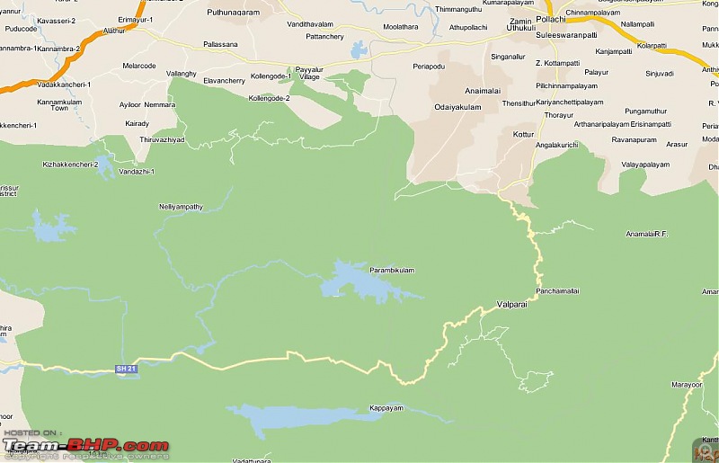
Google has mapped the roads incorrect here. Google says you can continue from Parambikulam to Chalakudy, which infact is wrong. The roads end at Parambikulam.

The road via valparai is the one that connects with Chalakudy.

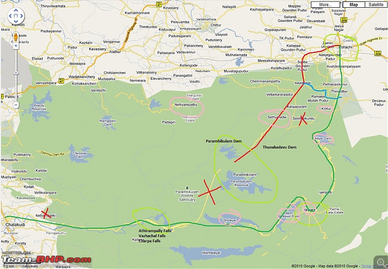
Yes. The routes are different. See this map. the cross indicates Google is wrong.

Red is the route from Pollachi to Parmbikulam
Green is the route from Pollachi to valparai, Athirampally and Chalakudy
Blue is the route for a shortcut if Valparai and Parambikulam is combined in a same trip.
Civved : Parambikulam, Gavi, Vagamon via Thekkady & Valparai-map1.jpg

To get an orientation of the places I had been this trip, please see this map.
Civved : Parambikulam, Gavi, Vagamon via Thekkady & Valparai-map2.jpg

The places from North to South are
Nelliyampathy
Parambikulam
Valparai
Munnar, Kodai
Idukki
Vagamon
Thekkady / Kumily
Gavi
Sabarimala


Hope this helps to get the idea of those green belts. Above nelliyampathy it goes all the way up till coorg and above, and is disconnected from this stretch by the Palghat gap through which NH47 runs.


Quote:
Originally Posted by fazalaliadil View Post
Lalu,
This is turning out to be a very informative thread, helpful for guys planning a visit there. Good photographs and panoramas, keep it up.
Thanks Fazal.
I am happy that the log is helpful, and will be looking forward to your wonderful wild life photography from this parts.
laluks is offline  
Old 6th September 2010, 09:10   #79
BHPian
 
MohsinRoadster's Avatar
 
Join Date: Sep 2009
Location: Bangalore
Posts: 301
Thanked: 31 Times

Elephant pics are amazing!! Ive always been admiring its mighty strength.
Views around the dam are beautiful.
MohsinRoadster is offline  
Old 6th September 2010, 09:20   #80
Senior - BHPian
 
jacs's Avatar
 
Join Date: Nov 2007
Location: Kochi
Posts: 1,499
Thanked: 1,047 Times

Lalu, panoramas of the dam view made me Wow. Most of the pictures are just amazing and offcourse the narration, my preference of pictures will go for the ones without special effects .

Not seen any predators? Waiting for the rest.
jacs is offline  
Old 6th September 2010, 09:32   #81
Senior - BHPian
 
vasoo's Avatar
 
Join Date: Jul 2007
Location: Memphis TN
Posts: 1,039
Thanked: 246 Times

Excellent thread Lalu. Would love to visit this places sometime soon.

Google maps can be as good or as bad as how the public community makes the changes. Google only provides with the base satellite map for most regions which cannot be wrong. Most of the roads, towns, and other geographic features are identified from the satellite map by the public community and marked. You might have observed a feature called "edit" for google maps. All are welcome to join the Google map community and edit the map so that it will portray our geography more accurately. Google is not going to do it. If you notice, many roads are drawn as straight lines in many places, just based on assumption as the roads are not visible in the satellite map, either due to thick foliage or forest cover, low resolution or old satellite pictures. If you are convinced about any of these roads, please go ahead and add them in the map. They will be reviewed by moderators and approved over a period of time. I have been doing this for quite some years and made so many changes in maps for south India, especially Kerala, Bangalore and some TN towns. I also does moderation for those who does similar changes. It is a very active community.
vasoo is offline  
Old 6th September 2010, 09:49   #82
Senior - BHPian
 
laluks's Avatar
 
Join Date: Sep 2008
Location: Bangalore
Posts: 6,552
Thanked: 16,397 Times

Quote:
Originally Posted by MohsinRoadster View Post
Elephant pics are amazing!! Ive always been admiring its mighty strength.
Views around the dam are beautiful.
Thanks MohsinRoadster

Quote:
Originally Posted by jacs View Post
Lalu, panoramas of the dam view made me Wow. Most of the pictures are just amazing and offcourse the narration, my preference of pictures will go for the ones without special effects .

Not seen any predators? Waiting for the rest.
Thanks jacs.
No predators seen in this trip :(

Quote:
Originally Posted by vasoo View Post
Excellent thread Lalu. Would love to visit this places sometime soon.

Google maps.... It is a very active community.
Thanks Vasoo.
Let me see if I can take some time with the Google community. I prefer to be active in only few communities, and hence you know
laluks is offline  
Old 6th September 2010, 10:20   #83
Team-BHP Support
 
ampere's Avatar
 
Join Date: Sep 2009
Location: Bangalore
Posts: 17,928
Thanked: 12,899 Times

Lalu,

Thanks for a perfect explanation. That clearly puts things in perspective.

PS: You see I have a major liking for maps and I do not rest till it soaks in correctly.
ampere is offline  
Old 6th September 2010, 10:39   #84
Senior - BHPian
 
hvkumar's Avatar
 
Join Date: Nov 2006
Location: Mumbai
Posts: 7,369
Thanked: 3,454 Times

ampere, as lalu has mentioned, the roads to Valparai & Parambikulam are different. As you exit Pollachi town towards Udumalaipet, you will see 2 separate rights, one going to Top Slip/Parambikulam via Anamalai and another going to Valparai/Atjirapalli via Aliyar.

There are OTR roads from Sholayar (Valparai-Athirapalli road) to Parambikulam and from Parambikulam to Nelliyampati, but these are not open to civilians and not possible in a normal car. Even KL forest officials prefer to travel from Palakkad (district HQ) to Parambikulam via TN (Pollachi & Top Slip).
hvkumar is offline  
Old 6th September 2010, 10:49   #85
Team-BHP Support
 
ampere's Avatar
 
Join Date: Sep 2009
Location: Bangalore
Posts: 17,928
Thanked: 12,899 Times

HVK, Thanks for that detail. I can see more clearly and also somewhat better marked in the MMI maps. Roads may/may not be correct, but at least locations of places seems to be correct.

Civved : Parambikulam, Gavi, Vagamon via Thekkady & Valparai-mmi.jpg
ampere is offline  
Old 6th September 2010, 10:49   #86
Senior - BHPian
 
laluks's Avatar
 
Join Date: Sep 2008
Location: Bangalore
Posts: 6,552
Thanked: 16,397 Times

Quote:
Originally Posted by hvkumar View Post
ampere, as lalu has mentioned, the roads to Valparai & Parambikulam are different. As you exit Pollachi town towards Udumalaipet, you will see 2 separate rights, one going to Top Slip/Parambikulam via Anamalai and another going to Valparai/Atjirapalli via Aliyar.

There are OTR roads from Sholayar (Valparai-Athirapalli road) to Parambikulam and from Parambikulam to Nelliyampati, but these are not open to civilians and not possible in a normal car. Even KL forest officials prefer to travel from Palakkad (district HQ) to Parambikulam via TN (Pollachi & Top Slip).
The OTR road to Vazhachal is from Kuriar kutty, around 9Km left of Parambikulam. It is a mud road, and was told that if the biggies nod OK, the forest department Jeep can be used here. It is a fun drive and nearly 2 hours to Vazhachal. I saw that route from Kuriar kutty. The immediate mud road seemed ok for a Civic though , Dont know when it changes to OTR territory.


@ampere - MMI seems to have stopped the roads to Parmbikulam at Sethumadai CP. Locations are correct though.

Last edited by laluks : 6th September 2010 at 10:52.
laluks is offline  
Old 6th September 2010, 11:09   #87
Senior - BHPian
 
hvkumar's Avatar
 
Join Date: Nov 2006
Location: Mumbai
Posts: 7,369
Thanked: 3,454 Times

Quote:
Originally Posted by laluks View Post
The OTR road to Vazhachal is from Kuriar kutty, around 9Km left of Parambikulam. It is a mud road, and was told that if the biggies nod OK, the forest department Jeep can be used here. It is a fun drive and nearly 2 hours to Vazhachal. I saw that route from Kuriar kutty. The immediate mud road seemed ok for a Civic though , Dont know when it changes to OTR territory.
Lalu, does it not go to Sholayar? Is it going directly to Vazahachal? I doubt it since the Peringalkuthu Dam reservoir must be intervening in between Sholayar and Vazahachal. What else did they say of the OTR road? Permissions granted by whom? Possible to travel during rainy season or only in dry weather conditions?
hvkumar is offline  
Old 6th September 2010, 11:23   #88
Team-BHP Support
 
ampere's Avatar
 
Join Date: Sep 2009
Location: Bangalore
Posts: 17,928
Thanked: 12,899 Times

Quote:
Originally Posted by laluks View Post
@ampere - MMI seems to have stopped the roads to Parmbikulam at Sethumadai CP. Locations are correct though.
That was exactly my opinion too. Also the mud road; does it need 4x4? In rains it must be really loose!
ampere is offline  
Old 6th September 2010, 11:43   #89
Senior - BHPian
 
pjbiju's Avatar
 
Join Date: Apr 2006
Location: Pune
Posts: 1,357
Thanked: 1,089 Times

Wonderful travelogue with lovely pictures as usual laluks. Loved the special effects shot of the kannimara teak and the panoramic shots. Also thank you for all the details. I need to plan a trip to this place next time I am in Kerala. The last time I drove to Valparai from my home (90 km) and came back home the same way (via Vazhachal, Malakkapara).

Btw, it is Athirappilly (അതിരപ്പിള്ളി) and not Athirampally.

Biju
pjbiju is offline  
Old 6th September 2010, 11:48   #90
Senior - BHPian
 
laluks's Avatar
 
Join Date: Sep 2008
Location: Bangalore
Posts: 6,552
Thanked: 16,397 Times

Quote:
Originally Posted by hvkumar View Post
Lalu, does it not go to Sholayar? Is it going directly to Vazahachal? I doubt it since the Peringalkuthu Dam reservoir must be intervening in between Sholayar and Vazahachal. What else did they say of the OTR road? Permissions granted by whom? Possible to travel during rainy season or only in dry weather conditions?
You are right. The guide said it goes some where near Vazhachal. The initial part of that road seems to be along the Karappara riverside - a water channel for the let out water from Parambikulam Dam (Parambiar River), and the water from Thellickal River (Kuriarkutty River) joins. This part of the road looked like a proper road, though made of mud and metal. I was told this is in the Orukomban range and goes all the way to Peringalkuthu. Then it becomes a proper 4x4 road, around 15km to the Vazhachal road. Could be nearer to Sholayar said than Vazhachal.

The initial part of the road which I saw can get slushy in the rains, don't know the rest of it.
Permissions are by Forest Department biggies. Not for all, only their "Guests or recommendations" as told to me by the guides.

How about we both on a trip down there with your Scorpio and with all needed blessings from the biggies? I'd love to explore there. Other wise we'll take a two day Tram way trek which anyways goes through these areas.

Quote:
Originally Posted by ampere View Post
That was exactly my opinion too. Also the mud road; does it need 4x4? In rains it must be really loose!
What I saw needs just a jeep. If the road deteriorates still further then you need a 4x4. Most forest department jeeps there have 4x4s. It can get slushy I guess, I have only seen the initial 500m.


Quote:
Originally Posted by pjbiju View Post
Wonderful travelogue with lovely pictures as usual laluks. Loved the special effects shot of the kannimara teak and the panoramic shots. Also thank you for all the details. I need to plan a trip to this place next time I am in Kerala. The last time I drove to Valparai from my home (90 km) and came back home the same way (via Vazhachal, Malakkapara).

Btw, it is Athirappilly (അതിരപ്പിള്ളി) and not Athirampally.

Biju
Thanks Biju. That "m" can be ignored

Last edited by laluks : 6th September 2010 at 12:07.
laluks is offline  
Reply

Most Viewed


Copyright ©2000 - 2024, Team-BHP.com
Proudly powered by E2E Networks