| |||||||

 |
| Search this Thread |  13,297 views |
 1st May 2018, 12:42
| #1 |
| BHPian | |

|  (13)
Thanks (13)
Thanks
|


| |
|
1st May 2018, 17:33
| #2 |
| BHPian | |
|
| (6)
Thanks
|


|
1st May 2018, 21:14
| #3 |
| BHPian | |
|
| (12)
Thanks
|


|
2nd May 2018, 11:57
| #4 |
| BHPian | |
|
| (8)
Thanks
|


|
2nd May 2018, 13:30
| #5 |
| BHPian | |
|
| (13)
Thanks
|


|
2nd May 2018, 15:13
| #6 |
| BHPian | |
|
| (15)
Thanks
|


|
2nd May 2018, 15:40
| #7 |
| Team-BHP Support  | |
|
| (2)
Thanks
|
|
2nd May 2018, 18:37
| #8 |
| Senior - BHPian Join Date: Sep 2014 Location: Chennai
Posts: 4,960
Thanked: 9,163 Times
| |
|
| (1)
Thanks
|
|
2nd May 2018, 20:37
| #9 |
| BHPian Join Date: Nov 2011 Location: Chennai
Posts: 225
Thanked: 158 Times
| |
|
| (4)
Thanks
|
|
3rd May 2018, 11:10
| #10 |
| BHPian Join Date: Aug 2008 Location: Trivandrum
Posts: 396
Thanked: 748 Times
| |
|
| (9)
Thanks
|
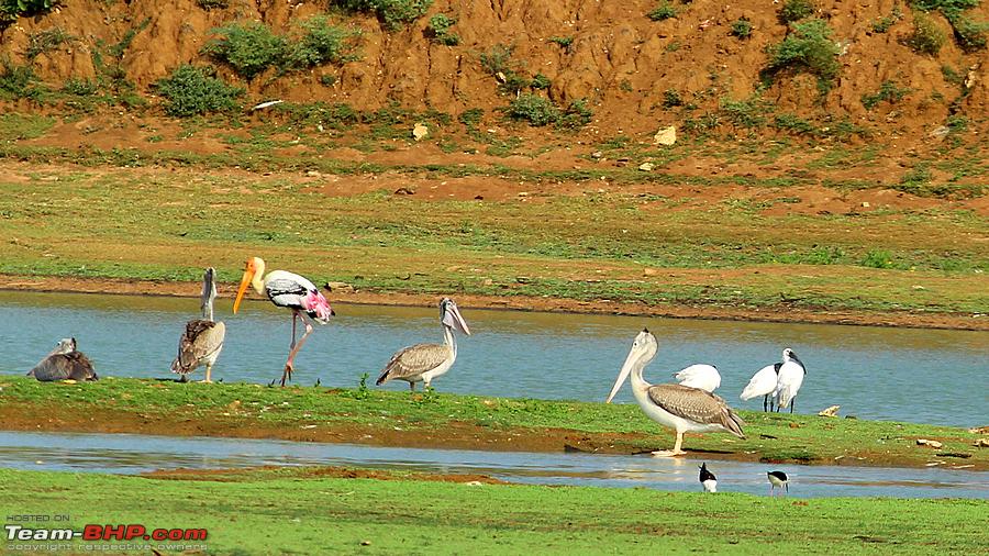
 Those are the Spot-billed Pelicans and in the water with them is the Bar-headed Goose. The BHGs and Flamingos are stationed further deep into the Koonthamkulam (approx 8 KM from the main tank area). That's the point where you can catch many varities of Raptors too. In last season, rain was pretty heavy in Koonthamkulam side that the main tank area was almost submerged till the village road. I was there in December & February and looked like being flooded.


|
3rd May 2018, 14:40
| #11 |
| BHPian | |
|
|

| |
|
4th May 2018, 14:13
| #12 |
| BHPian Join Date: Feb 2013 Location: Mumbai
Posts: 344
Thanked: 505 Times
| |
|
| (2)
Thanks
|
|
4th May 2018, 14:33
| #13 |
| BHPian Join Date: Dec 2012 Location: COK-PKD-SZX
Posts: 873
Thanked: 2,750 Times
| |
|
| (2)
Thanks
|
|
7th May 2018, 19:08
| #14 |
| Distinguished - BHPian  Join Date: Jul 2011 Location: Bangalore
Posts: 3,738
Thanked: 13,540 Times
| |
|
| (1)
Thanks
|
|
11th May 2018, 17:13
| #15 |
| BHPian | |
|
| (1)
Thanks
|
|
Most Viewed