Team-BHP > Travelogues > Route / Travel Queries
Register New Topics New Posts Top Thanked Team-BHP FAQ


Reply
  Search this Thread
42,239 views
Old 31st March 2010, 19:06   #1
BHPian
 
KALINGA's Avatar
 
Join Date: Dec 2009
Location: PUNE
Posts: 724
Thanked: 374 Times
Athirapilly Waterfalls - Indian Niagra

Hi All,

Just got a mail regarding Athirapilly Waterfalls in KERALA. but not much information regarding this. Can anyone have much info(Road map/route/accomodetation etc. and ofcourse photo ) regarding this waterfall?

Mod:- Please merge the thread if it is already here.
KALINGA is offline  
Old 31st March 2010, 19:14   #2
Team-BHP Support
 
ampere's Avatar
 
Join Date: Sep 2009
Location: Bangalore
Posts: 17,952
Thanked: 12,943 Times

Quote:
Originally Posted by KALINGA View Post
Hi All,

Just got a mail regarding Athirapilly Waterfalls in KERALA. but not much information regarding this. Can anyone have much info(Road map/route/accomodetation etc. and ofcourse photo ) regarding this waterfall?

Mod:- Please merge the thread if it is already here.
High level summary: Its on the Chalakudy river. Best way to go is from Trichur. Please be more specific as to from where one needs to go to this place.
ampere is offline  
Old 31st March 2010, 19:47   #3
BHPian
 
KALINGA's Avatar
 
Join Date: Dec 2009
Location: PUNE
Posts: 724
Thanked: 374 Times

Quote:
Originally Posted by ampere View Post
High level summary: Its on the Chalakudy river. Best way to go is from Trichur. Please be more specific as to from where one needs to go to this place.
Thanks AMPERE.

if any one want to go from Cochin or coimbatore then what will be the route.

I heard that its a huge waterfall. Any pics you have??

Last edited by KALINGA : 31st March 2010 at 19:48.
KALINGA is offline  
Old 31st March 2010, 19:59   #4
Senior - BHPian
 
aargee's Avatar
 
Join Date: Jan 2010
Location: TSTN
Posts: 6,236
Thanked: 9,643 Times

If you go via Coimbatore, then the way is Coimbatore-Palakkad-Thrissur-Chalakudi
If via Kochi, then Ernakulam-Aluva-Angamaly-Chalakudi.
Both the above ways are in opposite direction, means, Coimbatore to Chalakudi is travelling towards West & Ernakulam to Chalakudi will be from South to North
aargee is offline  
Old 31st March 2010, 20:34   #5
Team-BHP Support
 
ampere's Avatar
 
Join Date: Sep 2009
Location: Bangalore
Posts: 17,952
Thanked: 12,943 Times

Aargee has already answered the question. The point is what all your friend wants to cover in his travel? Accordingly we can see how it can be planned.

I do have some pictures, but somehow they are not with me on my laptop. I had been in november some two years back, but I did not see much water.
I will fetch them up and post.

Last edited by ampere : 31st March 2010 at 20:36.
ampere is offline  
Old 31st March 2010, 20:52   #6
BHPian
 
Join Date: Feb 2009
Location: Kochi, Bangalore
Posts: 203
Thanked: 81 Times

Quote:
Originally Posted by aargee View Post
If you go via Coimbatore, then the way is Coimbatore-Palakkad-Thrissur-Chalakudi
If via Kochi, then Ernakulam-Aluva-Angamaly-Chalakudi.
Both the above ways are in opposite direction, means, Coimbatore to Chalakudi is travelling towards West & Ernakulam to Chalakudi will be from South to North
If you are travelling from Ernakulam, then instead of going till chalakudi, take a right after angamali. That will take you through a plantation. It will be an easier way. And there wont be any traffic in this road also.
ArunV is offline  
Old 31st March 2010, 22:27   #7
Senior - BHPian
 
hvkumar's Avatar
 
Join Date: Nov 2006
Location: Mumbai
Posts: 7,369
Thanked: 3,454 Times

If you go via Chalakudy (On NH47,20 kms from Trissur - to the North, 50 kms to Ernakulam/Kochi - South), you turn East,
Chalakudy-Athirapalli, 33 kms

If you go from Angamali (On NH47, 14 kms from Chalakudy - North, 2 kms to Angamali - South), you turn East,
Angamali-Turn off NH47 2 kms-Mokanur 5-River Bridge 23-Athirapalli 10

If you come from Valparai (81 kms - East),
Valparai-Malakkiparai 22-Sholayar 24-Peringalkuthu Dam 25-Vazhachal 5-Athirapalli 5
hvkumar is offline  
Old 2nd April 2010, 22:12   #8
Senior - BHPian
 
sbraj's Avatar
 
Join Date: Mar 2008
Location: B L R / T V M
Posts: 1,071
Thanked: 9 Times

Quote:
Originally Posted by hvkumar View Post
If you come from Valparai (81 kms - East),
Valparai-Malakkiparai 22-Sholayar 24-Peringalkuthu Dam 25-Vazhachal 5-Athirapalli 5
HVK Sir, I never knew of this route. How is the road condition? And the nature of roads (ghat sections)? I guess this goes through Parambikulam WLS.

P.S. I wonder in awe at your posts.
sbraj is offline  
Old 2nd April 2010, 22:21   #9
Senior - BHPian
 
ranjitp1's Avatar
 
Join Date: Jun 2007
Location: Hyderabad
Posts: 3,712
Thanked: 1,926 Times

Quote:
Originally Posted by KALINGA View Post
Thanks AMPERE.

if any one want to go from Cochin or coimbatore then what will be the route.

I heard that its a huge waterfall. Any pics you have??
the waterfall would be in full bloom only post monsoons in Kerala around July-August(again dependent on how good the monsoon is!)
ranjitp1 is offline  
Old 2nd April 2010, 22:53   #10
BANNED
 
Join Date: Jul 2007
Location: Bangalore
Posts: 2,440
Thanked: 1,235 Times

Google given this page for pictures of Athirapally:

My-Kerala.Com: Athirapally Waterfalls

Last edited by wildon : 2nd April 2010 at 22:55.
wildon is offline  
Old 2nd April 2010, 23:10   #11
Team-BHP Support
 
ampere's Avatar
 
Join Date: Sep 2009
Location: Bangalore
Posts: 17,952
Thanked: 12,943 Times

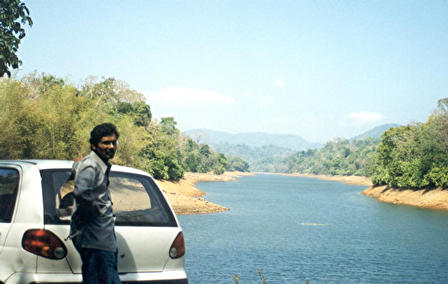
Here are some snaps, that I could take out from my cabinet ! Before going to the falls about 10 Km before we stopped at a resort for lunch. It was on the river and hence it was fun. Dont recollect the name though. It was here we heard India win the Perth test match ! I will never forget the lunch!

Athirapilly Waterfalls - Indian Niagra-dsc00841.jpg

Athirapilly Waterfalls - Indian Niagra-dsc00848.jpg

Athirapilly Waterfalls - Indian Niagra-dsc00874.jpg

Athirapilly Waterfalls - Indian Niagra-dsc00885.jpg

Athirapilly Waterfalls - Indian Niagra-dsc00888.jpg

Athirapilly Waterfalls - Indian Niagra-dsc00890.jpg

Athirapilly Waterfalls - Indian Niagra-dsc00891.jpg

Athirapilly Waterfalls - Indian Niagra-dsc00898.jpg

Athirapilly Waterfalls - Indian Niagra-dsc00906.jpg

Athirapilly Waterfalls - Indian Niagra-dsc00907.jpg

Athirapilly Waterfalls - Indian Niagra-dsc00908.jpg
ampere is offline  
Old 3rd April 2010, 00:08   #12
Senior - BHPian
 
hvkumar's Avatar
 
Join Date: Nov 2006
Location: Mumbai
Posts: 7,369
Thanked: 3,454 Times

Quote:
Originally Posted by sbraj View Post
HVK Sir, I never knew of this route. How is the road condition? And the nature of roads (ghat sections)? I guess this goes through Parambikulam WLS.
One of the loveliest of drives in the entire Western Ghats region, one of my favourites in India. Leaving the tea estates of Valparai behind at the Kerala border at Malakkiparai, the road cuts through bamboo jungles (tress often 3 stories high arched across the road forming a canopy), with cicadas chirping away causing an unbelievable din, spectacular blue waters of the Sholayar Dam reservoir, always dreading the elephant at the next curve and mist wafting from the road surface.

I discovered this route entirely by fluke, mobiking one day randomly, in the Year 1987. Having been turned away at Sethumadai (checkpost for Parambikulam/Top Slip WLS - "sorry, no bikes"), we decided to go to Valparai. Once there, we were told that the "Punnagai Mannan Falls" (the Athirapalli Falls was featured in a popular Tamil movie) was "just" a "short" distance away. That "just short" turned out to be a 3 hour drive on what was absolutely uninhabited rainy area, without knowing head or tail what we could expect at the end of the trail. Even at that time, the narrow road (1 laner) was good, although you had to be very careful not to run into elephants. Having reached Athirapalli, I went on to Chalakudy.

I have driven on this route after that a few times. Now they also have the option of crossing the Chalakudy River and going directly to Angamali as I have explained in my earlier post. Last time I drove that way, the bridge was not there and I took my car in a ferry made of 2 catamarans strung together.
hvkumar is offline  
Old 3rd April 2010, 11:36   #13
BHPian
 
NutsNBolts's Avatar
 
Join Date: Jul 2009
Location: Jammu
Posts: 817
Thanked: 41 Times

If it is helpful, here are two routes in Google earth, first one Kochi to Athitappally and second from Coimbatore to Athirapally
Attached Thumbnails
Athirapilly Waterfalls - Indian Niagra-ath1.jpg  

Athirapilly Waterfalls - Indian Niagra-ath2.jpg  

NutsNBolts is offline  
Old 3rd April 2010, 14:14   #14
Senior - BHPian
 
hvkumar's Avatar
 
Join Date: Nov 2006
Location: Mumbai
Posts: 7,369
Thanked: 3,454 Times

Quote:
Originally Posted by NutsNBolts View Post
If it is helpful, here are two routes in Google earth, first one Kochi to Athitappally and second from Coimbatore to Athirapally
The second route (Pollachi-Parambikulam-Sholayar) is open to the public only from Pollachi to Parambikulam via Top Slip. The rest of the road is a rough jeepable track allowed to be used only by the Kerala Forest Department. You will also note that there is a thread on OTR in that track part of the way, from Sholayar Dam. So forget driving on this road, it is not even a navigable road. But, yes, it promises to be one of the best drives in the Western Ghats area, but considering that this is thick elephant territory, it is kept kept away.
hvkumar is offline  
Old 3rd April 2010, 14:21   #15
Senior - BHPian
 
hvkumar's Avatar
 
Join Date: Nov 2006
Location: Mumbai
Posts: 7,369
Thanked: 3,454 Times

Some photos from my collection:
Sholayar Reservoir, Valparai-Athirapalli road, Feb 2002


Valparai, Feb 2002


Aliyar Dam, climbing up from Pollachi to Valparai, Apr 1989


Athirapalli Falls, May 1988


Athirapalli Falls, May 1988


Last edited by hvkumar : 3rd April 2010 at 14:22.
hvkumar is offline  
Reply

Most Viewed


Copyright ©2000 - 2024, Team-BHP.com
Proudly powered by E2E Networks