Team-BHP
(
https://www.team-bhp.com/forum/)
- -
Chiplun to Pune route
(
https://www.team-bhp.com/forum/route-travel-queries/78876-chiplun-pune-route.html)
Friends,
Satnav on Garmin suggested a route from chiplun to pune through Mahad, Raigad, Davase road - Raigad road, Sinhagad and pune.
I knew of the route from poladpur to Pune through Mahabaleshwar, Wai.
I also knew of the route through Varandha Ghat (road just before the toll gate on NH17)
I also know a route exists through Tamhini ghat, pirangut to Pune.
Now I was crazy to follow Garmin / Satguide like a T (it was damn accurate from Pune to Kolhapur to Ganapatiphule to chiplun, tracing like a T)
I climbed up Raigad fort and that's where garnin lost it.
I was constantly asked to go to the highlighted route (which showed the Dasave road - Raigad road).
After climbing up the Raigad route, the route forket to two. One pointed rope way. Another started climbing down hill.
The crazier part was that I was driving past midnight. I took the route that climbed down the other side. Soon the road vanished and it was pure gravel.
Fearing a tyre puncture at odd hours, I turned back, got back to Mahad, hit the road to Varandah ghat.
Call me crazy, but I stopped and asked directions from a group of youngsters trekking the raigad hillocks at 1:30 am.
Drove back and reached Pune at 4:46 am after an arduous drive over the Varanda ghats.
at 1:30 am, somewhere in the ghat section, nearly ran over a rabbit almost 9 - 10 inches. Never seen one so big. Hit the breaks and got of the road on to dirt and created a cloud of dust.
Didn't hear running over it and didn't find any thing on my tyres. So left happy that the rabbit was safe. Can't kill a bunny on easter morning you see.
Anyway coming back from the OT, Is there a route suggested by Satguide from Raigad to Pune?
Have a look at the photo attached. Z is Mahad. Y is Raigad. I did Z to Y and back after not finding a road. The yellow line with dots finally show the route I took from chiplun - Mahad - Raigad - Mahad - Varandha ghat - bhor - Pune
The black solid line I drove is part of the route suggested by Satguide that I couldn't find from Raigad.

Calling all travel gurus for their comments.
Which is this road - Dasave-Raigad? You took the road from Lavasa?
Quote:
Originally Posted by hvkumar
(Post 1819929)
Which is this road - Dasave-Raigad? You took the road from Lavasa?
|
Apparently that's what I thought. Thought it should join the Lavasa route someplace. Because from Pune to lavasa, I did notice the road stating to Dasve gaon.
But I was travelling from Chiplun up on NH17, branched off at Mahad and drove up to Raigad. The map from satguide shows there's a route from Raigad to Pune thru Sinhagad. I've marked the places as x, y and z on the pic posted. x = sinhagad, y = raigad and z = mahad.
The Amba ghats from Kolhapur to Ratnagiri was in great shape! The views were panoramic. I was reminded of the dimbham ghat roads.
The road from kolhapur was patchy but I could easily keep 75. Then it dramatically improved when I hit the ghats. Amazing drive it was.
Ashishpallod and others, please let me know about my raigad to pune query. The Boss has spoken already and has asked about Lavasa route.
AFAIK, there is no road from Lavasa to Raigad, the only way is through Varandah Ghat. Or via Mulshi Lake. The Lavasa Road (from Dave Dam) curves around to the Warasagaon Dam and goes on to Panshet Dam to take a complete circuit around the reservoirs of the Warasagaon, Temghar and Panshet Dams.
Yes HVK. That's what google earth showed as well. But this map from Satguide shows this line (highlighted in dark black by me) that shows a non existant route.
Quote:
Originally Posted by MX6
(Post 1819780)
Friends,
I climbed up Raigad fort and that's where garnin lost it.
I was constantly asked to go to the highlighted route (which showed the Dasave road - Raigad road).
After climbing up the Raigad route, the route forket to two. One pointed rope way. Another started climbing down hill.
The crazier part was that I was driving past midnight. I took the route that climbed down the other side. Soon the road vanished and it was pure gravel.
|
For a moment I thought that WOW this a new road taking Pune to the nearest beaches!
There is one more route not mentioned by you. IMHO it the best road from Chiplun to Pune via Koynanager - Patan - Satara - Pune. It is probably a bit longer but is well maintained whenever I have traveled, and you reach the 4 lane NH4 after Patan (~ 90kms from Chiplun). Remaining distance on NH4 to Pune is approx 120kms.
like alto99 said the best route is indeed the Koynanagar-Patan-Umbraj-NH4. Kumbharli ghat is fun to drive and road condition is pretty decent all the way to the highway. No idea of the black line in the map, even if it exists it is bound to be a very bumpy ride!
Quote:
Originally Posted by MX6
(Post 1819957)
Ashishpallod and others, please let me know about my raigad to pune query. The Boss has spoken already and has asked about Lavasa route.
|
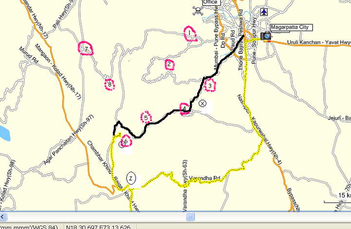
@mx6,
if you look at edited map above, the points are---
1] pirangut
2] lawasa road
3] velha phata on sinhgad road
4] the singhgad road joins to nasarapur-velha road. [ the circular road at point 4 is gunjawani road at the base of rajgad.]
5] velha [ base of torna fort]- taluka place
6] raigad
7] vile phata on pune-kolad/mangaon road
8] three major u turns in tamhini ghat from which you can get view of raigad fort if weather permits.
the road showed by garmin is nothing but ancient trek route which connects raigad fort-lingana fort-torna fort[ velha town] and do not touch dasave village in any case.
this trek route still exist and it will take three full days for raigad to torna[ velha] via singapur nal. singapur is small village at the top of ghat between lingana maachi and velha.
Btw, new ghat named as Madheghat is proposed between mahad and velha. the route will be
mahad-shivthar ghal-madhe ghat-velha. that will be nearest route between mahad and pune, just 90 km.
the pic shows madheghat top, i was there three years back to check the route and spot. sorry for very poor pic quality.

Yes, currently this is a trekkers' route. It would benefit Puneites if this becomes a motorable road.
Thanks AP. That explains. So do we have a road existing between 4 and 5? If so, then all we need is a road between 5 and 6 to complete that route and make it motorable. Seems there' already a road between 3 and 4 from your response. And I've driven to Sinhagad from Pune.
Quote:
Originally Posted by MX6
(Post 1821242)
Thanks AP. That explains. So do we have a road existing between 4 and 5? If so, then all we need is a road between 5 and 6 to complete that route and make it motorable. Seems there' already a road between 3 and 4 from your response. And I've driven to Sinhagad from Pune.
|
Point 5 is velha, one of the taluka place in pune district, so, there is road from pune via sinhgad and via nasarapur.
After velha, the road continues till the village named pasrli [ something similar], after that, one road leads to madheghat, other leads toward singapur area[ not up to singapur].
You have to walk toward singapur after end of road.
The roads after velha are hopeless, it took 45 min fast drive to cross 16 km road between velha and madheghat.
Definitely there is a road between 5(Velhe) and 4(turn towards Sinhgad) as I drove on it this Saturday..but as Velhe sits right at the base of Torna, road between 5 and 6 will be very tricky indeed as it will have to cross the main ridge of Sahyadri to Raigad.
Quote:
Originally Posted by ASHISHPALLOD
(Post 1820741)
the singhgad road joins to nasarapur-velha road. [ the circular road at point 4 is gunjawani road at the base of rajgad.] velha [ base of torna fort]- taluka place
this trek route still exist and it will take three full days for raigad to torna[ velha] via singapur nal.
|
Wow! Never knew such a road existed.
Relied upon the locals more than maps during our trips - because these maps aren't clear. Have attached maps from Bing and Google. In fact, Raigad is not plotted!
SH 96 is not visible at all in Google (even the Bhor - Wai road is missing?!)
Has anyone tried SH96? Haven't gone beyond Torna...
Yes. The road as per AP exists till Torna from Pune side. And SH96 exists till Raigad from Mahad. Beyond Raigad, I did motor down hill on other side on pure gravel. Frightening proposition to do on a ford ikon with all family at 1 in the night with raging forest fires. So I did a u-turn and got back. One day I should drive down from Raigad the other side to see where the path leads. Maybe will do that when I get my 4 wd.
So Satguide is not the only wrong one. Bing's showing a non-existant route as well.
Any MMI owners can you throw your 2 cents worth of thoughts please?
Quote:
Originally Posted by vrprabhu
(Post 1821418)
Wow! Never knew such a road existed.
SH 96 is not visible at all in Google (even the Bhor - Wai road is missing?!)
Has anyone tried SH96? Haven't gone beyond Torna...
|
sh 96 do not exist.
there is no tar/motorable road from velha to raigad.
the trek route is velha-singapur nal-lingana maachi-raigad.
please, do not attempt to travel on this route by car/ by trek.
only experienced trekkers try to do this route.
there are no hotels, no food joints, no petrol pump, no puncture shop after velha.
the area is so remote that even myself was got confused in the jungle at madheghat at @ 7 pm and we were circling the car in
smashan.:eek:
| All times are GMT +5.5. The time now is 00:14. | |
