| Re: Earthquake in Gujarat
Quote:
Originally Posted by sgiitk  One problem with GSI is that they do not trust data from across the  . So the triangulation is from sensors all on one side of the event. The USGS data may be more reliable.
One thing though, apparently no casualties - Good news, is it due to better awareness after the Bhuj disaster.
anjan_c2007 please comment and enlighten us, you are our resident expert. |
Thanks sgiitk.Its not actually that we do not take others data on face value. In fact, we rely more on the IMD,USGS and our own data.We have just begun to establish our own Broad Band Seismic (BBS) observatories in select locations. If the observatories are networked and there are scores of them spread across the length and breadth of the country, the retrieved data is more and more accurate.IMD is the nodal agency for earthquake data generation and storage in India and has a very good network of BBS observatories.
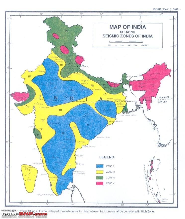
Coming to yesterday evening's quake in Gujarat, its epicentre was in Junagadh (Seismic Zone III). It had a magnitude of 5.3 on the Richter scale and occurred at 5.18 pm (IST) as recorded. The Bhuj area and NW Gujarat portion bordering Pakistan falls in Zone V, the most seismically unsafe area. Even the Himalayan foothills fall in Zone V as can be seen in the seismic zonation map of India appended here.In Maharashtra, Mumbai falls in Zone III, while Koyna falls in Zone IV.
Even areas in the vicinity of the unsafe ones are not very safe as ground acceleration of seismic waves and the harmonic resonant oscillations of civil structures can play havoc- its the waves behaviour at the critical moments that determine the quantum of destruction and its damage potential.The taller a building the more dangerous it is, given the fact that it is not earthquake resistant !
The 1985 Mexico earthquake (M 8.1) that had its epicentre in the country's West Coast created lesser damage near the epicentre, but Mexico city about 300 kms from the epicentre was ravaged.The soft sediments [Kolkata (alluvium) and Mumbai (tidal flats and reclaimed land) are dangerous in case of any seismic activity] on which a city's dwellings are built simply create havoc. Hard rock and building/ civil structure erected on hard rock foundations are much safer during seismic activity. And if the ground water level is shallow, its a curse at such times.Liquefaction can occur and all the soft soil and water liquify and turn into mud, annihilating the building foundations and structures thereafter.
During the Bhuj earthquake of 2001 during our studies we found that a luxurious, multi-storyed building Ahmedabad had a swimming pool on its seventh floor.The stored
water 's weight played havoc and its collapsed like a pack of cards.Even tall buildings with pillars at the ground floor (usually for parking) and no wall constructed are prone to belly landing as the pillars crumple and the whole structure falls.
The earthquake:
date 20/10/2011 time 17:18:34 Epicenter Latitude 21.2°N Longitude 70.7°E Depth from surface 10 kms magnitude 5.3 Location: DISTRICT JUNAGAD, Gujarat (from IMD data)
(Indian Standards Instn Map)
Last edited by anjan_c2007 : 21st October 2011 at 20:54.
| 

 20th October 2011, 23:40


 (1)
Thanks
(1)
Thanks