Team-BHP
(
https://www.team-bhp.com/forum/)
According to reports, two German tourists, Philipp Maier and Marcel Schione, were stranded in Australia's wilderness after Google Maps led them astray with a faulty route.

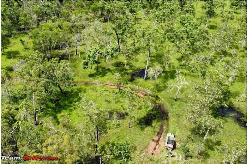
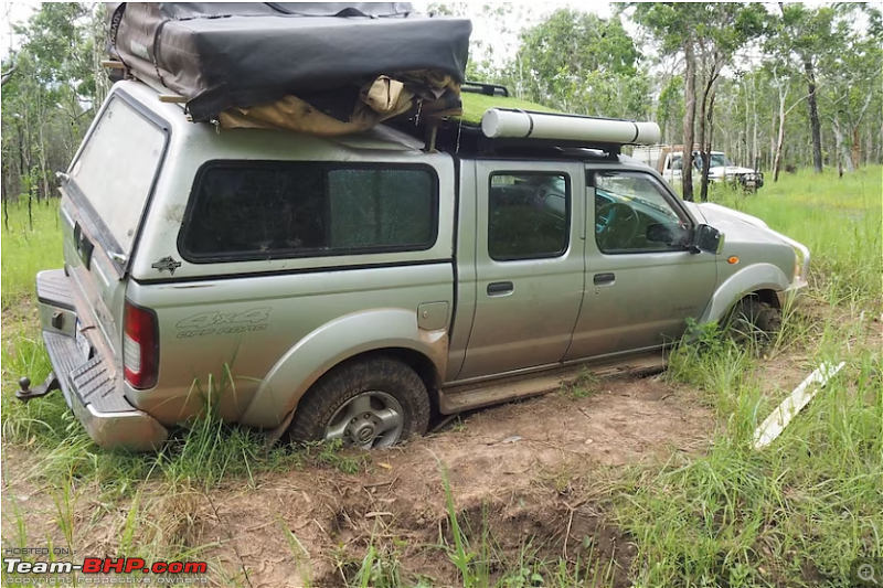
The two tourists embarked on what should have been a straightforward drive to the small town of Bamaga in Queensland's northern region. However, Google Maps led them on a different route via a remote dirt road, which turned out to be the entrance to Oyala Thumotang National Park - which has been closed to the public since December 2023. What's worse is that their vehicle sank into the wet mud, leaving them stranded and lost with no cell service or way out.
Reports state that the two tourists camped inside their car for almost a week, even trying to build a tent, before deciding to attempt an escape on foot.
A spokesperson from Google has since acknowledged the mishap and confirmed that the road in question has been removed from Google Maps. The spokesperson also stated, "We apologise for this incident and are relieved that Philipp and Marcel are safe. We can confirm that this path has been removed from the map."
Source:
TOI Link to Team-BHP news
Quite scary. Kept on driving for 60+ Kms into the forest even after not seeing any vehicle and people movement, quite an adventure's trip.
PC:
https://www.abc.net.au/news/2024-02-...area/103492986
Reminds of a similar incident in Russia, but that was tragic.
Quote:
18-year-old freezes to death after being stranded inside car on Russia's 'Road of Bones' for a week
According to local media, a 18-year-old Russian has frozen to death inside his car in the notoriously cold Yakutia region, after getting lost while driving in extreme temperatures. The youth was found dead after a week-long search. His friend has, however, survived the cold.
https://www.indiatoday.in/world/stor...139-2020-12-06
|
For the time being, we can avoid situations like this by relying on multiple providers, keeping paper maps as backup etc.
But, imagine what will happen when fully autonomous cars take over. It will trust the map blindly and declare you have reached your destination in the middle of nowhere! :eek:
This raises a question. Are dedicated navigation devices like Garmin better than Google maps? I am sorry if this is a noob question.
But I was thinking of investing in one of these as I do tour quite a lot and Google maps can be unreliable at times.
Do these sat-nav devices work where there is no mobile reception?
If traveling on slightly unusual / unfamiliar routes, at least what we do is also ask on our groups well in advance on what is the best route. Heck we do it here as well on our routes threads - inquire what’s the ‘actual’ best route for a journey notwithstanding maps. This is also sometimes supplemented with asking locals while on the journey.
I’m guessing that approach definitely remains relevant. In places like Australia, it’s possible some places don’t even have too many people en route or are just completely isolated and in wilderness. Helps to inquire in advance instead of exclusively relying on maps.
I recall a similar incident once when we were on our first holiday post having our kid (then 1 year old). Google maps in Goa led us up literally some sort of a desolate forest hill because it recognised it as a road while we were trying to get to some far off North Goa restaurant at around 8 pm. It was quite worrying what with we on our first trip out of home with a small baby. The path narrowed a little ahead to a point where we could not even U turn a small Wagon R. We had to drive till a point where we found a slight patch to allow a U Turn.
I find even now on some sections of roads I know really well (like entering Mumbai from JNPT side on a bike, google maps sometimes gives some weird detours which I just ignore because I know its got it wrong. So yes, secondary information should definitely still be used.
Quote:
Originally Posted by Mr.Ogre
(Post 5728790)
This raises a question. Are dedicated navigation devices like Garmin better than Google maps? I am sorry if this is a noob question.
But I was thinking of investing in one of these as I do tour quite a lot and Google maps can be unreliable at times.
|
If you do a lot of trips to remote areas then it might be a good investment, but they do seem to be expensive.
It is not about one being better than the other, but having multiple fallback options. I personally do the following when I'm making trips to remote places in Australia. The irony is that the definition of remote is, anything that's far away from cities.
- Ask the locals and people who've made the trip before hand and plan accordingly. The season and time of the day matters a lot.
- Choose a 4WD rental provider that can give me a customized itinerary/route plan.
- Buy printed HEMA maps for that particular region. The printed maps at times get sold out during holiday seasons! :Frustrati
- The digital HEMA maps that can be downloaded are pricey so I haven't got them.
- Take a CB radio/walkie-talkie.
- Know which channels to use and importantly, which not to use. Channel 5 and 35 are emergency channels and are not to be used except in an emergency. There are fairly hefty fines in place if you disrupt an emergency call on these channels. Channel 11 is the ‘call channel’ used to locate friends or other road users before quickly moving onto a different channel. Channel 18 is the caravan convoy channel, while channel 40 is for truckies or those wishing to communicate with truckies. For general chat, it’s safe to use channels 9, 12-17, 19-21 24-28, 30, 39, 49-60, 64-70, 79 and 80.
- Have at least one mobile phone that has a sim card serviced by Telstra mobile towers. Mobile reception outside of cities is a joke here.
- Download Google offline maps.
- Download digital maps from the National Parks website and print them.
- Plan the fuel stops. They are sparse.
Even after all of the above, I've lost my way around in some islands and thankfully got back on track without too much drama.
Australian outback driving requires a lot of planning and some international tourists under-estimate the importance of planning. The German tourists are lucky to be alive.
Imagine looking at this on your phone. :)

Here's a sample itinerary from one of our trips.


As a father of grown up kids I am glad these two young men are safe. I can only imagine the anxiety of their parents assuming they knew of the kids being lost.
Forgive me for the tone of the rest of my post. Before google maps and social media how did one navigate? Thirty years ago Indian highways and other roads did not even have proper signage. Then we carried paper maps + always but always talked to someone who had done the route before + every so often stop and ask for directions + keep common sense and sense of direction on alert to do a sense check on a "are we headed in roughly the right direction". Asking directions is feasible in most parts of India due to our population density and that advantage these two young Germans did not have, that I concede. But to be depending blindly on google in the wilderness is a reflection of an over dependence on anything that is online, a common habit these days be it online fake news or online purchases and getting cheated.
Any way all's well that ends well.
Quote:
Originally Posted by kiku007
(Post 5728814)
Australian outback driving requires a lot of planning and some international tourists under-estimate the importance of planning. The German tourists are lucky to be alive.
|
Coming from Europe which is densely populated and urban/semi urban almost all over I guess it is hard to fathom the depth and vastness of Australia's outback.
Quote:
Originally Posted by V.Narayan
(Post 5728827)
But to be depending blindly on google in the wilderness is a reflection of an over dependence on anything that is online, a common habit these days be it online fake news or online purchases and getting cheated.
|
Quote:
Coming from Europe which is densely populated and urban/semi urban almost all over I guess it is hard to fathom the depth and vastness of Australia's outback.
|
Denser Europe as well as a generational thing. This was one of the things going through my mind as well. At 47, I still come from a generation where combining maps with offline inquiry in remote places comes as force of habit or intuitively.
At some level, I get the predicament they landed into (as tourists from densely populated Europe into much more vast outback like you succinctly summed up). My sons generation though will be so dependent or habituated to using technology for such aspects, they really will have to be coached to also supplement some offline maker / checker principles (as obvious as it seems though) when in such places.
Some of them will learn this lesson the harder way like this German duo.
Quote:
Originally Posted by V.Narayan
(Post 5728827)
.. Before google maps and social media how did one navigate? ...
|
I share the same question. Not only for Goolgle Maps or Social media, even in olden days when we ask around, we went by not one persons instructions. Took few of them, then used common sense to consolidate on what we know to make a decision on which route to take. Also, keeping on driving without validating on an unknown route? Well..
Quote:
Originally Posted by Axe77
(Post 5728799)
I find even now on some sections of roads I know really well (like entering Mumbai from JNPT side on a bike, google maps sometimes gives some weird detours which I just ignore because I know its got it wrong. So yes, secondary information should definitely still be used.
|
Quote:
My sons generation though will be so dependent or habituated to using technology for such aspects, they really will have to be coached to also supplement some offline maker / checker principles (as obvious as it seems though) when in such places. Some of them will learn this lesson the harder way like this German duo.
|
I am discovering to my dismay that the next generation of drivers {Ola Uber please note} do not have a real sense of direction or muscle memory of even main roads. That is because they go purely by google maps. In my book if you have driven around a city on your own you develop a map in your head of the roads and your way around. A few days ago I was in Chennai with a hired Innova & a 24-year old driver who apparently had been driving around for a couple of years. But his muscle memory was very very poor caused by over reliance on Google. My memory of Chennai from 1985 when I was posted there for a year was way better. For those familiar with Chennai, he needed google map to get from IIT to Parry's Corner, effectively a straight road. I explained the need to memorize routes to him in a fatherly manner. It was a concept he was not familiar with.
Google is notorious for taking you onto roads that are narrow and very difficult to navigate, all in the interest of optimizing algorithms. This is particularly problematic in rural areas. The app needs to have an option to avoid narrow or rural roads. I have logged in this feature request with GMaps, but nothing has been done for over a year. I usually now drive with two options, GMaps as the main one and NaviMaps as an alternative. The latter has the option of avoiding narrow maps. In the event I see that GMaps is directing me into a narrow road, I fall back on NaviMaps before the two apps converge. Plus NaviMaps does not depend upon the internet, which is often a great relief
Quote:
Originally Posted by V.Narayan
(Post 5728846)
My memory of Chennai from 1985 when I was posted there for a year was way better. For those familiar with Chennai, he needed google map to get from IIT to Parry's Corner, effectively a straight road. I explained the need to memorize routes to him in a fatherly manner. It was a concept he was not familiar with.
|
Remember how we all knew at least 50 phone numbers by memory until the 90s?
Right now, I only remember my number and my wife's number. :Frustrati
Overdependency on technology has made us all dumber and helpless without technology.
Quote:
Originally Posted by V.Narayan
(Post 5728846)
the next generation of drivers {Ola Uber please note} do not have a real sense of direction or muscle memory of even main roads. That is because they go purely by google maps.
|
The loss of sense of direction is just the beginning.
Thanks to a reliance on AI, subsequent generations will even lose their ability to think through any aspect properly.
That would be the advent of the supremacy of AI. And the end of the human race as we know it now.
As many have predicted, the end of biological evolution and the beginning of the technological one.
How is it Google Maps fault that they got stuck in the mud.
Darwin at work, again.
Quote:
Originally Posted by kiku007
(Post 5728814)
It is not about one being better than the other, but having multiple fallback options.
…
|
Great pointers there. Downloaded offline maps, and also not sticking to one specific app is something I follow. For example, though Google maps is my default map app, when driving in Europe I use Apple maps mostly; find it more accurate, better in re-routing and most importantly, and efficient speed camera alerts. But if driving in India, its normally Google maps (Apple maps is almost useless there).
Quote:
Originally Posted by V.Narayan
(Post 5728827)
Before google maps and social media how did one navigate? Thirty years ago Indian highways and other roads did not even have proper signage. Then we carried paper maps + always but always talked to someone who had done the route before + every so often stop and ask for directions + keep common sense and sense of direction on alert to do a sense check on a "are we headed in roughly the right direction".
|
Quote:
Originally Posted by Axe77
(Post 5728831)
Denser Europe as well as a generational thing. This was one of the things going through my mind as well. At 47, I still come from a generation where combining maps with offline inquiry in remote places comes as force of habit or intuitively.
|
It is indeed the generational thing. I used to laugh / dismiss /frown when my parents used to say they used to walk around 10 kms (luckily no swimming and rock climbing) everyday to go to school. Now I get a similar reaction from my daughter – she complain on the long 7 mins wait for her bus to school, and I go on like stop complaining, during my school days I used to wait for one whole hour patiently for my bus :)
It’s a fact that conveniences/technology spoil us immensely, but having a basic understanding/rough idea of the terrain/location we are traversing is very important. At least that may help to get out of the situation safely. It was a pleasant surprise when I
lost way in the Italian countryside last year, but the same situation in Philadelphia couple of years back took me to an extremely scary/unsafe looking street.
| All times are GMT +5.5. The time now is 11:09. | |


