| |||||||

| Search Forums |
| Advanced Search |
| Go to Page... |
 |
| Search this Thread |  17,537 views |
 27th April 2011, 23:25
| #1 |
| Senior - BHPian Join Date: Aug 2007 Location: BLR
Posts: 1,148
Thanked: 680 Times
| Bangalore -Nagarhole- Irpu (Coorg)- Muthanga (KL) Round Trip Undertook a Bangalore -Nagarhole- Irpu- Muthanga trip over the last long weekend 21-24 April 2011. Day 1. Bangalore– Mysore – Hunsur – Nagarahole- Kutta- Irpu falls Leg one distance covered 270 km We started early morning at around 5:30 am to beat the terrible traffic conditions near Mysore road –Kanakapura section. I was low on fuel and was looking out for a bunk, to my surprise could not find any petrol bunks open on the old airport stretch. Finally tanked up my Santro (28 lits) on a BP pump on Mysore roads. It was cloudy and drizzling hence limited my speed to max 80kmph. At around 7 am had a quick idly vada , coffee breakfast at the Kamat, this place seems to be a bit expensive these days. Refreshed we headed straight to Mysore , before entering Mysore city took a right turn at Columbia Asia on the ring road, this road is still under construction hence had to slow down quite often. Our next destination was Hunsur around 40 km from Mysore, there were no proper road signs hence stopped number of times to get proper directions. Hunsur to Nagarahole stretch was quite smooth and there was very little traffic. Reached Nagarahole forest check post around 9:45 am, everyone(Wife & Kids) was excited and was trying to spot animals, we managed to spot the Langur, Giant squirrel , spotted deer , Sambar , wild pigs, jungle fowl , woodpecker, hornbill and Kingfisher to name a few. We thoroughly enjoyed the slow ride through the Nagarahole forest, watch out as there are plenty of unmarked speed breakers hence keep your speed in check. Overall the roads were in decent condition. After exiting Nagrahole we headed towards Kutta, the road were winding surrounded by lush green coffee plantation. This road was very unevenly patched everywhere you have to be alert to spot and avoid potholes. From Kutta onwards the road conditions further deteriorates it is quite narrow and you have to struggle to keep yourself on the road if a vehicle comes from opposite side. I was busy concentrating on the potholed road and in the process missed a small lane which was supposed to lead us to Irpu falls hence we went around couple of time wasted around 45 minutes locating our home stay. At these places Vodafone had no signal but my Airtel had no-1-2 bars signal, make sure if you want to call and ask for direction do it much ahead. Reliance seems to have a better coverage as the home stay owner had one. Reached home stay by around 12:30 pm. Had our lunch at home stay and took some rest. Evening it was dark and cloudy hence we just explored areas around Irpu falls. Learning’s : Nagarahole stretch is only open to traffic between 6 am to 6pm  Spotted Deer @ Nagrahole  Langur @ Nagrahole  Irpu -Coorg Day 2. Irpu falls- Kutta – Nagarahole –Kutta -Tholpetty - Kuruva Islands Leg two distance covered 90 km Morning was quite cloudy & misty , after breakfast we headed straight to Irpu falls it was just half km from our home stay. Irpu fall is situated around 700 mts inside from the main gate hence be prepared to a little trekking, climb quite a few steep stairs. Word of caution there are lot of blood sucking leaches on the way hence make sure your legs are well covered. Carrying a matchbox or salt can be helpful in removing leaches if you get any, luckily none of us got a leach. Generally on weekends and holidays this place is crowded, since we reached around 9:00 am there were not many people at Irpu falls . Had a quick shower at the falls and left the place by 11 am. Went back to homestay had lunch and after a quick nap headed for Nagarahole as the safari starts at 3 pm. We reached Nagrahole only to find that the safari was cancelled for next 2 days due heavy rains. Since we had time we headed back to Kutta and took a diversion towards Tholpetty (wild life sanctuary), as we entered Kerala border we were welcomed by super smooth well tarred roads in one word “just superb”, there was absolutely no traffic, the winding roads was a true delight. After reaching Tholpetty we came to know that the safari is stopped since last 6 month, no regrets. The bamboo & teak lined road were so tempting that without a second thought we drove down passed through the forest and reached a place called Katikulam . Took an approx 5 km deviation towards Kuruva Islands reached around 3:45 pm , we found out that they don’t allow anyone to cross Kabini river after 3:30 pm was a bit of disappoint, however we decided to return again next day. Drove back to Kattikulam and tanked up fuel at a small IOC pump my Santro gulped around 16 lits. Calculated mileage was around 18.5 kmpl with around 40 % AC usage. On the way back towards Kutta we encountered heavy rains, luckily we had day light hence we thoroughly enjoyed the lonely wet forest drive. Learnings : Take extra sets of clothes for changing, for females there is no decent place for changing wet clothes. There are not many decent places to eat hence we tried to have most of the meals at home stay. Day 3. Irpu falls- Kutta - Tholpetty - Kuruva Islands > Katikulam > Manandavadi > Kalpetta >Sultan Bathery > Muthanga & back to Irpu Distance covered 240 km Our plan for the day was to go to Kuruva Islands stay there till noon and return to Irpu, as planned we reached Kuruva island by around 9:00 am only to find that due to last night’s heavy rains Kabini river was having high water level & turbulence, hence no one was allowed to cross the river which leads to Kuruva island this was quite disappointing. Since we never planned anything else, we were wandering what to do next! on enquiring some locals suggested us to visit Pookot lake (55 km )and Muthanga wilde life sanctuary around 40 km from Pookot in the other direction. We headed towards Pookot , passed by Manandavadi reached Kalpetta town around noon had our lunch at woodlands restaurant , I liked the chicken biryani and fish meals priced at Rs 75 & Rs 50 respectively Quite cheap anytime. Pookot was still 10 km away and there was lot of traffic in Kalpetta town, since we were running late we dropped the Pookot lake plan and headed toward Muthanga wild life sanctuary . Word of caution, keep asking for direction else there is a high probability of loosing you way. Passed by Sultan Bathery and reached Muthanga at around 2:15 pm only to know that there is a token system in place and only 20 tokens are allowed during the 3-5 pm visiting hours. 20 token means 20 vehicles can enter the safari that’s it, had a tough time requesting people to take us along. Finally at around 3:30pm a group of 5 college students who had a token allowed us to come along with them. Inside Muthanga we only manage to spot some elephants, wild boars & deer’s the ride inside that Mahindra jeep was quite rough as the jungle roads were laid with uneven stones aggregates. You can take a private vehicle inside the safari if you can get a token, but truly it’s not worth taking your vehicle as your risk damaging your suspension and tyres. The safari ended by 4:30pm it was already cloudy and getting dark, I was quite concerned as I have to drive a long way back in forest territory after sunset. I drove quite fast and tried to cover up maximum distance after crossing Sultan Bathery we asked for direction back to Manandavad, we took a right turn at Beenachi (I guess). It was raining heavily hence had to slow down considerably . Reached Katikulam at almost 7 pm since it was not raining I was a bit relaxed and went ahead and tanked up around 12.5 Lts at a BP pump mileage came to around 19Kmpl with 10 % AC. After refueling headed for Kutta via Thollapetty forest road. I must have covered around 8 km and again it started pouring… boy, I have never experienced such heavy rain fall, I was not able to see any dam thing on road , got a little scared as I was totally blinded by rain in the middle of nowhere. The newly laid tarred road had a good reflective median marking which was of great help I just followed the median at a speed of around 10-15kmph, the visibility was hardly 3-5 meters. Had to stop couple of times as some spotted deers were crossing the roads. After 15 minutes the rain stopped abruptly and it was such a relief, I was now maintaining a speed of around 50 kmph and wanted to cover up the forest stretch at the earliest. Reached homestay at around 8 :00 pm . Some learning don’t drive in the dark if you are not familiar with the terrain another important point to remember is that after dark the roads are deserted and you will not find any one to ask for even basic direction. Cell phone coverage in these areas is quite patchy, in forest areas there is no coverage at all, in-case of a breakdown or even a simple puncture during night time can be a difficult to handle. Learning’s • Reach Muthanga early say by 12:30 -1 pm and collect the token after that you can go around exploring that place. • Don’t hesitate to ask for directions. • Roads are narrow hence keep left at all times as you can expect vehicles appearing from nowhere especially transport buses.  Swollen Kabini River  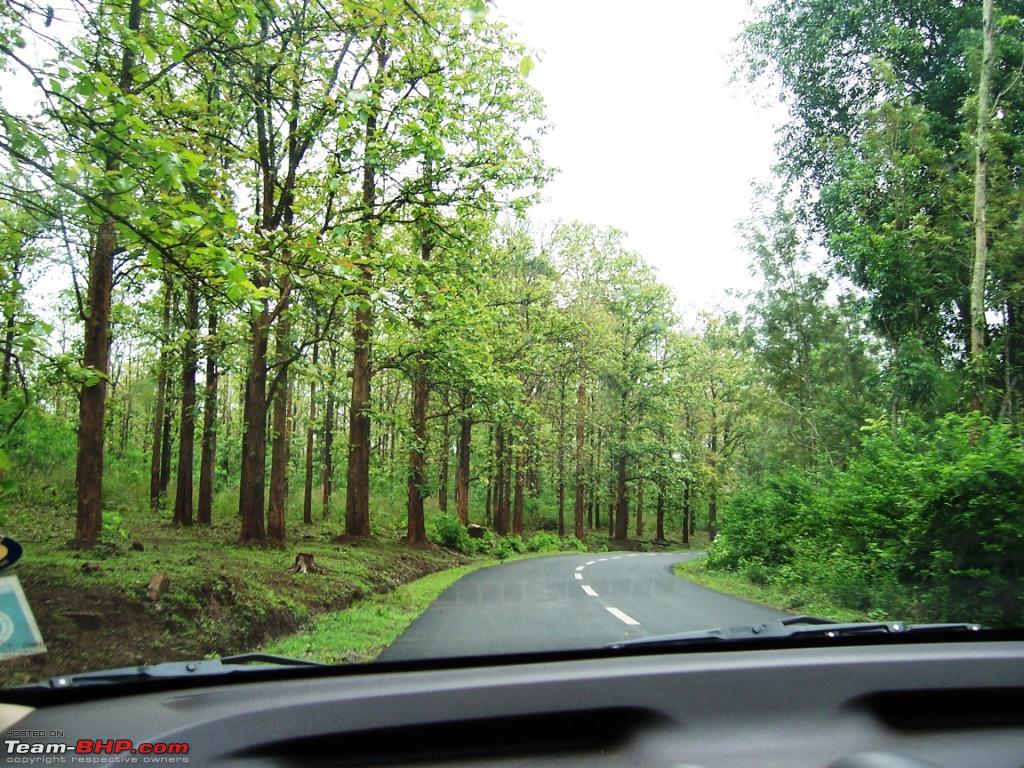  Kutta - Tholpetty road Day 4. Irpu falls- Kutta –Nagarahole- Hunsur- Mysore – Bangalore Distance covered 260 km Stared around 9:00 am and reached Bangalore around 4:30 pm , lost almost 1:30 hrs as we entered Bangalore. Distance covered in this leg of the journey was 260 km. Total trip we covered around 860 Kms and the average fuel efficiency which I got is around 18.8 kmpl, while returning used AC 100%. Last edited by benbsb29 : 29th April 2011 at 16:04. Reason: Edited formatting of pics. |

|  ()
Thanks ()
Thanks
 |
| |
|
28th April 2011, 18:22
| #3 |
| Senior - BHPian Join Date: Aug 2007 Location: BLR
Posts: 1,148
Thanked: 680 Times
| Re: Bangalore -Nagarhole- Irpu (Coorg)- Muthanga (KL) Round Trip We stayed in a home stay near Irpu falls it was quite in an interior place, the home stay name was Hill side Irpu estate, they charged Rs 1250/- per person /night inclusive of food. For a couple it works out to be 2500/- per night . The rooms was not good, there were some leakage, no charging point , no electricity most of the time. We were served food made for lunch during dinner also, if you ask me personally I did not like the homestay as I felt it was not value for my money, I am certainly not going to endorse Irpu estate period My camera batteries were not charged hence could not take many pics. I am attaching a link from which I did the booking Irpu Estate homestay| Nagarahole Homestay | Nagarahole Stay | Nagaraho I suggest you arrange your stay at Kutta or Nagarahole from there it is easy to cover Waynad side. Irpu falls is a bit interior. |
|
| ()
Thanks
|
|
29th April 2011, 10:24
| #4 | |
| BHPian Join Date: Oct 2009 Location: Bangalore/Chennai
Posts: 151
Thanked: 3 Times
| Re: Bangalore -Nagarhole- Irpu (Coorg)- Muthanga (KL) Round Trip Quote:
| |

| ()
Thanks
|

|
29th April 2011, 12:18
| #5 | |
| BHPian Join Date: Sep 2010 Location: Hyderabad
Posts: 68
Thanked: 19 Times
| Re: Bangalore -Nagarhole- Irpu (Coorg)- Muthanga (KL) Round Trip Quote:
I would highly recomend this place. Chers!!! | |
|
| ()
Thanks
|
|
29th April 2011, 13:54
| #6 | ||
| Senior - BHPian Join Date: Aug 2007 Location: BLR
Posts: 1,148
Thanked: 680 Times
| Re: Bangalore -Nagarhole- Irpu (Coorg)- Muthanga (KL) Round Trip Quote:
Quote:
| ||
|
| ()
Thanks
|
|
29th April 2011, 14:08
| #7 | |
| BHPian Join Date: Mar 2007 Location: Bangalore/Gulbarga
Posts: 167
Thanked: 34 Times
| Re: Bangalore -Nagarhole- Irpu (Coorg)- Muthanga (KL) Round Trip Quote:
Please share the contact details of the homestay that you referred (Kibbel). How far is it from Madikeri town? If one travels by bus to Madikeri, how do we reach that homestay? Do they have pickup and drop facility from the nearest bus stop? Best regards, Whitesquall | |
|
| ()
Thanks
|
|
29th April 2011, 16:06
| #8 | |
| BHPian Join Date: Sep 2010 Location: Hyderabad
Posts: 68
Thanked: 19 Times
| Re: Bangalore -Nagarhole- Irpu (Coorg)- Muthanga (KL) Round Trip Quote:
This is about 45-50 KMs from Madikeri and 20 KM from the nearest town (Gonikuppal) I'm not 100% sure of the bus routes there; better you call and check. I will PM you the details | |
|
| (1)
Thanks
|
| The following BHPian Thanks Sabby-069 for this useful post: | whitesquall |
|
29th April 2011, 16:59
| #9 |
| BHPian Join Date: May 2008 Location: Bangalore
Posts: 201
Thanked: 32 Times
| Re: Bangalore -Nagarhole- Irpu (Coorg)- Muthanga (KL) Round Trip The quality of the hospitality of the home stay largely depends on the owner of the homestay and their motto. Some of the homestays that I stayed in Coorg and Chikmagalur (Thippanahalli homestay) does NOT run with the business motto. They believe in spreading their presence by word of mouth and take enough care to make the guest feel at home. Some of them are in VFM range. At the same time, homestay concept threads a different line compared to resorts. Guests to homestays should have set their mentality that they are heading to a home away from home and should not except all the luxuries of a well stuffed resort at a homestay (like pick-drop, swiming pool, etc). |
|
| ()
Thanks
|
|
3rd May 2011, 09:52
| #10 | |
| BHPian Join Date: Oct 2009 Location: Bangalore/Chennai
Posts: 151
Thanked: 3 Times
| Re: Bangalore -Nagarhole- Irpu (Coorg)- Muthanga (KL) Round Trip Quote:
| |
|
| ()
Thanks
|
|