| |||||||

| Search Forums |
| Advanced Search |
| Go to Page... |
 |
| Search this Thread |  69,830 views |
 7th September 2011, 10:28
| #76 |
| BHPian Join Date: Feb 2007 Location: Bangalore
Posts: 250
Thanked: 121 Times
| Re: Ladakh & Zanskar: The road(s) less travelled Great - truly awesome and mesmerizing travelogue! The quality bar is held high and made higher with each subsequent post replete with crisp photographs. Harsh - thinking about any coffee table book? |

|  ()
Thanks ()
Thanks
|
|
7th September 2011, 11:17
| #77 |
| Team-BHP Support  | Re: Ladakh & Zanskar: The road(s) less travelled Harsh, So what is the state of development between Padum to Zanskar? I went through the whole of Wikimapia to actually follow what you were saying! Amazing places; Amazing drive! |
|
| ()
Thanks
|
|
7th September 2011, 12:40
| #78 | ||
| BHPian Join Date: Jul 2010 Location: New Delhi
Posts: 297
Thanked: 845 Times
| Re: Ladakh & Zanskar: The road(s) less travelled Quote:
Quote:
Well it would take at least another 3-4 years to be completed. The work is going on in full swing, but given the terrain and weather conditions there are a lot of limitations when the work can actually be done. So far, the road has been blasted about 40km from Leh side and 65km from Padum side. | ||
|
| ()
Thanks
|

|
7th September 2011, 13:50
| #79 | |
| Team-BHP Support | Re: Ladakh & Zanskar: The road(s) less travelled Quote:
I did mean Zanskar. You mentioned that the person (at the Dhaba) at Zanskar saying if they could complete the road from Padum, it would add to tourism. Did you mean Padum-Leh road there also? I thought it was from Zanskar and hence thought there could be a road from Manali to Kargil via Suru Valley which would bypass Leh. | |
|
| ()
Thanks
|
|
7th September 2011, 17:07
| #80 | |
| BHPian Join Date: Jul 2010 Location: New Delhi
Posts: 297
Thanked: 845 Times
| Re: Ladakh & Zanskar: The road(s) less travelled Quote:
Currently, the constructed road is till 20km from Darcha and about 43km south of Padum till a village called Itchar. So all in all 63km have been constructed, a further 85 odd kms still remain, of which the most difficult part would be to construct for the ascend and descend of Shingo La. | |
|
| (1)
Thanks
|
| The following BHPian Thanks vardhan.harsh for this useful post: | ampere |
|
7th September 2011, 22:52
| #81 |
| BHPian Join Date: Jul 2010 Location: New Delhi
Posts: 297
Thanked: 845 Times
| Day 10 (18th July): Juldo - Padum - Karsha Gompa - Padum (140 kms, 8 hrs) Having gone to bed at 10 the previous night, we woke up early, and promptly went to Tashis dhaba for breakfast as wed promised. He was waiting for us, and quickly made some omelettes which we had with bread and cheese that we were carrying. After a photo shoot with him, we said our goodbyes, although only temporarily as we promised that wed be back for lunch on our return journey. We wouldve been on our way pretty soon but Aartis love for sheep made me wait for another 15 min or so, while she spent some time with them.  An early morning at Juldo, around 6:30am  Tashi, in front of his dhaba, Panzi La dhaba.  Sadly the clouds covered the Nun and Kun peaks, devoiding us of a view  A herd of sheep, the right one has a great expression  Sleepy sheep Moving on, we took the shortcut again through Surus basin and stopped for a moment to look at the memorial stone of the terrorist attack that happened a decade ago in the region. In the year 2000, terrorists had walked all the way from Kishtwar with the bakarwals (Kashmiri shepherds) and had entered the Zanskar valley at Shafat. They had then hijacked a lorry in which a German tourist was taking a lift, shot three monks of the Rangdum gompa who tried to help the German, and then eventually also killed the tourist before disappearing. Ever since then, the bakarwals are not welcome in the valley and there have been tensions between the two communities. After crossing the Tashi Tongtse village, we entered Marmot Country II, this time the population density being even higher! Pretty soon we began our ascent to Pensi La, which basically is a fraud! This would have to be the most gentle ascent of any pass situated close to 4000 m in India. We were at the top at about 9:30 and it had taken us hardly about 2 hours. In our excitement to see the views of the Drang Drung glacier, we had not taken too many pit-stops on the way. The pass itself is nothing exceptional, but the lakes around it make it quite scenic. Just before one reaches the top, one can see the source of the Suru river to the left.  The memorial stone for the 3 lamas who were shot dead in the terrorist attack  Parting shot of the Randgum Gompa  A collection of some of the marmots we saw enroute  The 'climb' to Pensi La begins, if one could call that a climb  If you look closely, you can see the glacier where Suru originates  Almost at the top, nearing Pensi La  A panorama of the lake and the watch-tower at Pensi La  The board marking Pensi La, and the prayer flags of course The view of the gigantic Drang Drung glacier appears just around a bend, and if one is not mentally prepared for it, it could come as a pleasant shock. The huge glacier appears all of a sudden out of nowhere, and the best part is that it is right next to the road. Wed been waiting with bated breath for the glacier, and now that it was in front of us, we were truly speechless. Wed known for quite a while that this glacier would be the high point of our trip, but to actually witness it right in front of us was an overwhelming feeling. The glacier starts from the mountains on the left of the road, and as it flows down, does a classic twist, which makes it all the more lovely. We parked our car on the side, and reveled in the scale of the sight before us for sometime. Both of us sat on a rock next to the road, silent, admiring nature at its best. Even the shutter remained silent. Finally, after about 20 minutes, we got up and began walking around, trying to get different views and angles to capture the massive glacier. After spending about half an hour doing this, we moved on, only to realize from another bend a few kms down the road that if we hiked a bit, we could we bang in front of the glacier, and would get even better shots. Our estimate said that the hike would not take more than 10 odd minutes, and so we set off. However, as is usually the case with these hikes, it took us much more than 10 minutes, but the hike was worth the view we got at the end. We could see the glacier in all its glory, from end to end, i.e, from its source to its snout. The classic twist of the glacier looked more pronounced from this view point. Thankfully, there were some clouds which made it possible for us to just sprawl over a rock and relax! With Padum hardly a couple of hours away, we had ample time to kill. Soon, the sun came out, and we decided it would be better for us to hit the road again. All in all, I think the glacier took a good two hours of our time. Satiated, we moved ahead, glad to know that we would see the colossal glacier again in a few days.  The first view of the Drang Drung glacier  If you look closely, Aarti can be located, thereby giving you an idea of the scale of the scenery.  There are few places in India where a road is so close to a glacier of this size  The switchbacks and the glacier  The classic glacial twist The drive from Pensi La to Padum took us about 3 hours overall, and we reached there just in time for lunch. The road is in a pretty bad condition, more so because it has never been tarred. The drive is jittery, the road being level but full of pebbles, but it does not have potholes or slush, thus 4x4 is not a necessity. It is also devoid of settlements and it is only when one gets close to Padum that small settlements begin. For the longest time, one drives next to the Stod river, also called Doda by some. As we crossed the bridge at Tungri, the unthinkable happened - we saw tar! Aarti was convinced that the tarred road would not continue all the way till Padum, but it fortunately did! After driving for 1.5 days on stones, the smoothness of tar was very relaxing.  The road beyond in Zanskar valley  The road stays above Stod river for a while  It is devoid of any habitation or vegetation for a long time.  The road does not seem to have been tarred 'ever'. PWD zindabad!  Soon greenery begins in Zanskar, people say this is yellow in September end. In Padum, we immediately began our search for some decent accommodation for the next 3 days that we were going to spend there. Some huge trekking groups had converged on Padum from all directions, and all the decent hotels and guest houses were taken. The JKTDC was available at 200 bucks a day, although the state of affairs inside the room was quite horrible. Having no other option, we decided to stay there for a night, and then move to a better hotel by the name of Geyskit in the main market the next day. Although a tad expensive at 1200 bucks a day, it was much more comfortable. The restaurant was great as well. Lunch happened at the New Geyskit restaurant further up on the main market road, which is a must visit restaurant in Padum. It dishes out fantastic local cuisines, especially the Shabalay. With a bit of sunlight still left, we decided to head to Karsha Monastery, which offers some outstanding views of the Padum and Pishu villages. The road goes all the way up till the monastery now and from there one climbs a flight of steps to reach the top. I would highly recommend to make the monastery an evening trip as it offers a commanding view of the valley, which looks all the more divine in the dying light of the sun. We spent a lot of time there, just sitting in their central courtyard, relaxing. It was one of those rare peaceful evenings of our trip. Thereafter, we returned to Padum, and called it a day after having a delicious dinner at Geyskit restaurant.  The road to Karsha, which juts out of the mountain ahead.  Post Box: Karsha  The monastery complex at Karsha  A lama thought the skull looked nice in front of his room's entrance  A lama looks over his land from atop the Karsha Monastery  Me looking over the lama's land atop Karsha  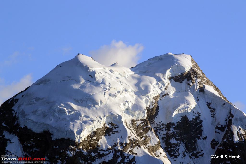 Haftal peak stands above Padum, is the source of Haftal stream as well. |
|
| ()
Thanks
|
|
8th September 2011, 09:58
| #83 | |
| BHPian Join Date: Jul 2010 Location: New Delhi
Posts: 297
Thanked: 845 Times
| Re: Ladakh & Zanskar: The road(s) less travelled Quote:
 | |
|
| ()
Thanks
|
|
26th April 2012, 14:58
| #84 |
| BHPian Join Date: Jul 2010 Location: New Delhi
Posts: 297
Thanked: 845 Times
| Day 11 (19th July): Around Padum - End of Road-Zangla and Stongde (130 kms, 7 hours) I somehow never realized completely that I had left the log in the middle. A 2 week out of Delhi official trip just broke the momentum of my writing and I never restarted the log. For the sake of completion and for those who are interested in the interiors and lesser travelled roads of Zanskar, I revive this! ~~~~~~~~~~~~~~~~~~~~~~~~~~~~~~~~~~~~~~~` Day 11 (19th July): Around Padum - End of Road-Zangla and Stongde (130 kms, 7 hours) It was a very lazy beginning to the day and I was out to get some tea for the both of us when I met Col. Vohra. He was also staying at the JKTDC hotel in the room next to ours, and was traveling alone with the first leg of his journey being Zanskar. He further planned to cover a lot of areas in Changthang, and being from the Army, his Safari could go to regions where us mere mortals can only dream of going! Over tea, we exchanged stories, and finally parted after taking some shots of all of us together - the three of us and our two steeds, one black, the other white. It was a matter of real coincidence when we got to know that Col. Vohra camped right next to our friends tent at Chandratal two weeks later. The world is indeed small for like-minded travelers.  White and black Safaris look good standing next to each other The facilities at JKTDC were poor, to put it mildly. There was hardly any water in the bathroom, the rooms were quite dirty and there was also no provision for hot water because the kitchen was not working. After getting ready, we checked out from there and went straight to Geyskit hotel where we first checked in, and then sat down for a longish and tasty breakfast in their cosy restaurant. Finally, at about 11 am, we left the hotel to embark on our plan for the day. We got to know from the locals that Gustor, the annual festival of the Stongde Monastery, was going on. Gustor is typically celebrated in November end, by which time the entire Zanskar valley is disconnected by road. This year, however, they had decided to celebrate it during the tourist season, as this would also lead to more money flowing into the local economy. One could call it commercialism, but I would prefer to call it smart thinking. We decided to first check out the end of the road beyond Zangla (yes, the journeys-to-the-ends-of-roads are back with a bang!), which was also on our agenda for the day. The road moves east out of Padum and is tarred almost all the way to Zangla, which is about 30 kms away. As one leaves Padum, the confluence of the Stod and the Tsarap Lingti rivers can be seen and the mighty Zanskar river is born.  The road towards Zangla is tarred all the way  Hoodoos: Formed by wind erosion over the years, reminds one of Spiti We crossed the Stongde village, which is about 10 kms from Padum, without stopping there. It took us about an hour to cross Zangla, and we moved on further, all the time driving next to the Zanskar river. The last village on the road is Zangla, after which all the villages lie on the opposite bank of the river, connected to the road with pedestrian bridges.  The wide valley beyond Stongde  A bridge over Zanskar river, at Chazar village The road beyond Zangla is also tarred, and remains that way till where the road ends. The valley before Zangla is VERY wide and really barren. However, beyond Hanumil, a village 25 kms from Zangla, the valley gradually narrows down, and becomes quite dark and more like a gorge. It probably stays this way all the way up till Chilling, where wed described the valley in a similar fashion when wed checked out the end of road beyond Chilling. The road extends a good 10km beyond Hanumil village.  Near Hanumil village  Kiyang enjoying tarred roads  Nearing the end of road, BRO does a thorough job, a road sign on an incomplete road!  A narrow gorge marks the end of the wide valley.  Similar landscape as that near Chilling village A few switchbacks later, we saw a landslide - a heap of stones on the road - and knew that this is where the road ended for Kiyang. We walked a bit up the road, but decided to take a U-turn about a km ahead. A few workers informed us that the road was complete till about 3 kms from there. We were back in the car by 1:30 pm.  Zingchen Topko (source: near Rangdum) joining Zanskar river.  The landslide that blocked further movement for Kiyang  That is Purfi La, the trek beyond goes towards Lingshed and Photoksar, and eventually to Lamayuru.  Zanskar snaking through the wide valley. We headed back towards Zangla, and reached there in an hour flat. The climb towards the Zangla fort is pretty steep and it was the first time 4WD was engaged in Zanskar so far. The fort looked pretty much deserted, and we had forgotten to take the keys from the owners in the village below. We knew about the key part because of our know-it-all guidebook! When we reached the fort, we made a small discovery - the road extended beyond the fort as well! We thought of exploring it further, but hardly 500 m ahead the road came to an abrupt end while descending. It was a difficult spot to take a U-turn and after probably 10-15 odd tries, we managed to finally do it. According to our Leomann map, a trek went from there all the way to Sarchu.  Zangla Village  The Zangla fort, and numerous chortens below it  The track ended abruptly beyond Zangla.  U-turn was pretty difficult here  Zangla fort from behind  Chortens beneath Zangla fort It was almost 3 pm by the time we reached the main road again and immediately started moving towards Stongde. The climb to Stongde is a little steep but manageable for a non 4WD. The sputtering of Kiyangs engine returned with vengeance on the climb and it once again lost power. It was quite baffling for me since we had got the filters cleaned at Kargil, and the car had responded well to that. However, here on this climb things were again going downhill. We decided to try the climb nevertheless. A climb on which I would not even have engaged the 4WD mode, I had to actually turn to the 4L mode for more torque. I made a mental note to make calls to some experts back home (read Tanveer) to resolve this issue when we reached Padum.  Pishu village across the river.  Trekkers make this their last halt before stretching towards Padum When we finally reached Stongde, the festival was about to end, and apparently the last ceremony was underway. Wed seen photographs of the Hemis festival, but it was great to actually see the Cham dancers perform live. We positioned ourselves on the roof of the monastery and started clicking away to glory. The sun was very harsh and we were sweating even in our light clothes, but the dancers seemed all happy and cheerful even in their heavy costumes! We witnessed the ceremony for about 20 minutes before it ended, and then made our way back to the car. In the outer veranda of the monastery, we stopped to have some bananas being sold by some local vendors, being hungry as hell. Around 5 pm, we finally left for Padum.  A masked Cham dancer at Gustor festival, Stongde  Interesting head-gear of the Cham dancers  An authentic Ladakhi head-gear of turquoise semi-precious stones. Costs about 5000 if one would want to buy a new one.  The entire populace of the nearby villages was there to celebrate  A guy watching the proceedings from above  An old woman enjoying the proceedings  It was colorfully decorated!  Little lama blowing his own trumpet As we reached Padum, I dropped Aarti to the hotel, and then referred to the guidebook to see possible causes of problems with Kiyang. On not coming to any conclusion, I made a call to Tanveer next, who thankfully took out a good 30 minutes to attend to my call during a working day. He diagnosed water in the sedimenter as the probable cause of the stalling of the engine. With detailed inputs on how to drain the water from the sedimenter from him, I went under the vehicle to get the job done. Afterwards, I took the car for a spin to test if things had improved, and they had considerably! Thanks buddy for helping me out, wonder what I would have done without your help. Once this was done, I realized how tired I was, and how badly I smelled of diesel. A quick shower was all I needed to get the stink off me, and get rid of some of the tiredness as well. Later, as we were sitting in the restaurant looking at the shots of the day and waiting for our pizza (Yes, pizza. Contrary to what one may think, they serve pretty good ones.), a guy came up to us to ask if we were working at the new dam site nearby. We, of course, responded in the negative, and he was pretty surprised to know that we were actually tourists. He explained that Indian tourists were quite uncommon in Zanskar, and it is primarily the foreigners who deem Zanskar fit to be on their itinerary. Hmmmm. The pizza was fantastic, and sleep came as soon as went hit the bed. |
|
| (3)
Thanks
|
| The following 3 BHPians Thank vardhan.harsh for this useful post: | aryasanyal, heman_369, SS-Traveller |
|
26th April 2012, 22:25
| #85 |
| BHPian Join Date: Jul 2009 Location: Bangalore
Posts: 460
Thanked: 63 Times
| Re: Ladakh & Zanskar: The road(s) less travelled Excellent photos and interesting narration, I bumped in to this thread today and was happy to spend the last 3 hours looking at the photos and reading through your narration. You have a wonderful flow and keeps me reading through it. Please continue to complete your travelogue. Thanks for sharing your experience and photos with us. |
|
| ()
Thanks
|
|
27th April 2012, 01:47
| #86 |
| BHPian Join Date: Feb 2009 Location: New Delhi.
Posts: 895
Thanked: 6,475 Times
| Re: Ladakh & Zanskar: The road(s) less travelled Now that's what you call a TL!!..What can one say? Beautifully written TL with wonderful photographs to match. Read through it one go and by the time i got to the top of page six wondered how it was going to end so quickly till i got to your latest post and realized how you revived the thread only today!! Rated 5 stars and am hoping that you will not keep us waiting for too long for your next post. Anytime you would like to repeat a trip to that region please do let me know. I have been itching to take my "Fort" up also.. (June isn't too far  haha...) haha...)Looking forward to the rest of the TL! Last edited by Manuuj : 27th April 2012 at 01:51. |
|
| ()
Thanks
|
| |
|
27th April 2012, 10:37
| #87 | ||
| BHPian Join Date: Jul 2010 Location: New Delhi
Posts: 297
Thanked: 845 Times
| Re: Ladakh & Zanskar: The road(s) less travelled Quote:
Quote:
| ||
|
| ()
Thanks
|
|
27th April 2012, 12:27
| #88 |
| BHPian Join Date: Jul 2010 Location: New Delhi
Posts: 297
Thanked: 845 Times
| Day 12 (20th July): Around Padum - Dzonkhul, End of road beyond Reru (135 kms) We got up early with the plan to first go to Dzonkhul and then come back for breakfast. Although Dzonkhul is on the way to Rangdum, stopping there on our way back would not have been possible due to lack of time, also a trip to Dzonkhul and further on to Padum would have been too much to do for a day. We were on our way by 6:30 in the morning. At the Tungri bridge, instead of taking the road which crosses the Stod river and goes on to Rangdum, we went straight. The ‘road’ now was quite bumpy and was being leveled by the villagers. At Ating village, we gave a lift to an old man who was going to the Monastery with supplies of a puja scheduled for that day. We then took a left towards the Monastery, and started climbing. Now this climb was awful, the road scattered with rocks of all sizes, and we moved at not more than 15 kmph. I would imagine 2WD jeeps facing extreme difficulties maneuvering through this stretch after the village and would suggest stretch essentially for 4WD as it is loose gravel with terrible ascent and U-bends.  Kiyang heading towards Ating village  Quaint Ating village  Umasi La up ahead, and so is Dzonkhul, The road lies in that scree to the right! Finally, after a very treacherous ascent, we reached the cave monastery of Dzonkhul. And what a sight it was! Built on a slope just below some jagged rocks, the Monastery peeks out of a cave, and the prayer flags adorning the monastery complex provide the much needed colour in the stark landscape. Village Dzonkhul must consist of less than five households, and most of them cater to the needs of the monastery. As we entered the monastery, a monk came to greet us, and then started showing us around. He first took us upstairs to a room the roof of which was the cave’s roof itself! It was very dark there with the little light coming from the burning lamps. The roof of the cave here was full of coins stuck to it, and looked like a dark sky with stars! We somehow managed to get one photograph since using flash was not allowed, and their was no way in heaven a tripod would’ve fit in that cramped room. After that we went to the terrace and then to a couple of other rooms which housed their ancient scriptures and books and other precious valuables such as cups studded with semi precious stones. They also had printing blocks of the scriptures and print new ones every now and then.  Dzonkhul monastery comes up from the caves  The imposing structure carved out of the mountain literally!  A starry roof, of coins  The darkest corner of the monastery  The view from the roof of the monastery  Rocks jut out inside the monastery everywhere 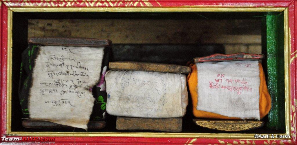 Ancient Scriptures Finally, the lama took us to a room where all the resident lamas of Dzonkhul were having their breakfast. They asked us to sit with them, gave us two bowls and filled them with the soup all of them were having. Now I know this will sound really mean, but that soup was AWFUL! I somehow finished mine, gulping down most of it so that it did not linger on my tongue, only to see Aarti looking expectantly at me to finish her portion too! I knew she wouldn’t have it, and that it did not look good not to accept their generous offering, so I had a second bowl too :( After thanking the lamas for the meal, we went downstairs and had chai with the people who were cooking lunch for the monks. They also gave us some bread, which was delicious! Over tea, we chatted a bit with them, and then bid adieu to Dzonkhul.  Ravens enjoying their breakfast  Abstract  A view of the Dzonkhul settlement  A little lama  Blue!  A cute kid in the kitchen  He was actually posing!  Another room of the monastery was way up, but we were not up for it The journey was quite tiring, and it was nearly 11 am by the time we reached Padum. After freshening up, we had an early lunch. The next thing to do was to check out Reru, which lies further south from Padum and the end-of-the-road beyond it. We left around 1 pm for Reru. We got lost at first. One has to go towards the older part of Padum, a Muslim dominated area, and take a left near the bus stand. The road runs parallel to the Tsarap Lingti, and the valley is pretty narrow. First up is the Bardan gonpa, perched precariously on top of huge stone which protrudes into the river. The road till Reru is tarred, although not very smooth, but after this the tar disappears completely. Here we saw a bunch of lamas playing cricket in a wide, open ground. About 6 kms from Reru, we came to a bridge to cross over to the right bank of the river. I believe this was the place where Salil went upto during his excursion to the region way back in September 2009. With the bridge now complete, we crossed over. The road from here on is very narrow and is a complete dirt track with a steep ascent to the village of Itchar. I wonder how would normal traffic cross this stretch given its sharp ascents, tight U-bends and narrow road.  A green patch of a village before Bardan monastery.  Tarmac all the way to Reru  Tsarap Lingti and Bardan  Another monastery complex beyond Bardan but before Reru (Meru was it?)  The beautiful green field of Reru  LPL - Lama Premier League  The dusty track beyond Reru 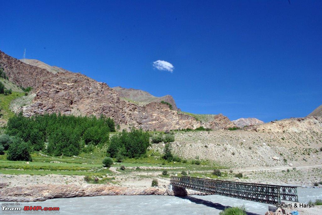 A bridge to cross over to the other side of Tsarap Lingti It was here when our car started acting up again, losing power on the incline! It was very frustrating, stretches which were supposed to be done in 4H mode were now being done in 4L mode and at extremely high RPM. There was an option to turn back towards Padum as the scenery was hardly beautiful or enticing, but being spoilt, we had to see the end of the road before we could turn back. We crawled ahead, occasionally having to deal with loss of power as well. The road was too dusty for me to crawl down and drain the sedimenter and decided that it would best be done on the way back. The road continued like this for about 8 odd kms from the bridge, before it came to an abrupt end where work was still being done. It was time for us to turn back. The drive back till Reru was again painful where I finally disembarked from the car and went down to drain the sedimenter. Once I was back on the wheel, the vehicle refused to start even after multiple cranks. Finally, I opened up the bonnet and primed the fuel pump a bit, and finally Kiyang started with a sputter. It was a smooth ride from that point till Padum which we finally reached by about dusk. This was the first detour that we regretted taking, the drive was neither beautiful nor worth taking, in our opinion. I would suggest further travelers to the region to avoid this drive until it’s complete all the way to Purne, which is about 15 km away from where the road ends currently. One could then trek to Phutgal gompa which I’ve heard is quite beautifully located, and the valley beyond Purne towards Kargyak and Darcha is very wide and spectacularly beautiful. Until then, it’s best to avoid the stretch. We had to start early the next day as we were targeting to reach Kargil in a single day from Padum, so hit the sack early. Last edited by vardhan.harsh : 27th April 2012 at 12:29. |
|
| ()
Thanks
|
|
27th April 2012, 16:03
| #89 | |
| BHPian Join Date: Feb 2009 Location: New Delhi.
Posts: 895
Thanked: 6,475 Times
| Re: Ladakh & Zanskar: The road(s) less travelled Quote:
Supplies, Water, Heated Interiors... hahaha! Just kiddin!Do please complete this TL soon..eagerly waiting for more!  | |
|
| ()
Thanks
|
|
29th April 2012, 06:18
| #90 | |
| BHPian Join Date: Jul 2009 Location: Bangalore
Posts: 211
Thanked: 317 Times
| Quote:
| |
|
| ()
Thanks
|
|