| |||||||

| Search Forums |
| Advanced Search |
| Go to Page... |
 |
| Search this Thread |  35,284 views |
 9th November 2011, 20:22
| #1 |
| Senior - BHPian Join Date: Nov 2005 Location: KL-47 // KL-53
Posts: 1,830
Thanked: 1,164 Times
| Wayanad and Coorg in Three days Warning: This is my first travelogue - so pardon with my style of writing. Might be too long - there are a few photos, so please wait for them to load. For the first time in my life, I was thinking of traveling to places, just to see them. We had three days at our disposal (it later got extended to four days). I started scouting for locations that we could visit from our home in Kerala over three days - the shortlisted locations were Kodaikanal, Ooty and Munnar. A friend in TN said it was raining heavily there, and Kodai/Ooty were struck off the list immediately. We re-drew our plans, and we now had Kollur Mookambika/Sringeri and Wayanad/Coorg on our shortlist. We chose the later, since all of us were longing to visit Thirunelli temple for a long time. I spent about a week reading various travelogues on Team-BHP, and pouring over Google Maps for routes and distances. I searched on the internet for details of various places we could see. All the while, we hadn't finalised our route, and hence we did not reserve rooms anywhere! The final Call for Wayanad and Coorg was made on a Wednesday. I was tied down with some presentations at College on Thursday, and had absolutely no time to make reservations. Finally, mailed a couple of Homestays in Coorg on Thursday night (all of them were booked out). On Friday morning, I called up KTDC at Thirunelli and blocked a room for Sunday night. They needed advance payment, which was made at the KTDC Office in Ernakulam. My brother helped me get a Homestay at Coorg (more details later), and he booked on MakeMyTrip. The Ride: My 2009 Fiat Punto MJD (Emotion) Travellers: My Dad, My Mom and your's truly. Day 01, November 06, 2011: Odo: 48287 Trip: 0.0kms Route Covered: Kodungallur-Gurvayur-Kunnamkulam-Kozhikode bypass-Thamarassery-Thusharagiri-Pookod-Kalpetta-Mananthavady-Thirunelli. We started off from home at 5:30 in the morning. The road had decent traffic - quite unusual for a Sunday morning. The road was in decent shape - since I am quite used to the route, run was a breeze. We took the Kodungallur-Chavakkad stretch of the NH17 (Chettuva-Chavakkad is horrible - the road is 1.5 laned, with potholes everywhere). Then turned off towards Guruvayur, and then continued on towards Kunnamkulam. From Kunnamkulam, got into the State Highway that runs upto Kuttipuram. The Actual NH17 runs through Chavakkad-Ponnani-Kuttipuram - the Ponnani-Kuttipuram stretch is horrible, and hence I usually avoid this route at any cost. The Kunnamkulam route is slightly longer (less than 5kms longer), but the roads are great.   My GP parked somewhere near Kottakkal, when I stopped for a photo-break! The traffic worsened after Kuttipuram - wasn't bad, but was high for a Sunday morning. I did not take the Valanchery bypass (which, they claim, saves time), but went through the town instead. Being vegetarians, we find it really hard to find decent restaurants anywhere in Kerala. My first preference goes to KTDC's Motel Araam - they are frequent on the NH17 as well. Therefore, we turned towards the town at Kozhikode, heading towards Motel Araam at Ramanattukara. Sadly, the Motel was closed - rather, they were opening later in the day. We turned back to the bypass and stopped at a hotel (forgot the name) right at the Ramanattukara Jn on the bypass. They had very few Veg options. We started off after Breakfast at 8:19 (Trip Meter: 149.5kms). Kozhikode bypass had very sparse traffic. Took a right at the end of the bypass. There was decent traffic from the place where we enter the road from the bypass, till we reached Kunnamangalam. I stopped a while after Kunnamangalam to stretch a bit. Took a couple of photographs, and then continued the run. Traffic was heavy as we reached every town on the route. As we near Thamarassery town, I saw a board indicating the turn to Thusharagiri Falls - had heard of this falls from a friend, and decided to have a look. One has to take a right turn at Thamarassery (while coming from Kozhikode). This road heads to Thiruvambadi. The falls is exactly 23.1 kms from the turn. The route taken is: Thamarassery-Koodathai-Kodenchery-Chembukadavu-Thusharagiri.  The roads towards Thusharagiri, from Thamarassery  Another shot.. Sadly, there are no sign boards anywhere (except the last few kms) on the route. After the right turn at Thamarassery, one has to take a left at every junction (ignore the small roads). At Kodencherry town, one has to take a right turn and continue on the main road upto Chembukadavu. There are plenty of sign boards in this section. At Chembukadavu, one has to take a right turn. Locals were very helpful, and they pointed us on the right track everywhere.  Two more kms to Thusharagiri.. For those coming from Mysore/Bathery side, there is a turn after Adivaram (Thamarassery Ghats). You have to turn left here. If you miss this turn, you can also turn at Eengapuzha town - just ask for Kodenchery/Thusharagiri.  Finally at Thusharagiri We reached Thusharagiri at 10:01. Thusharagiri is an Eco-Tourism point, and is managed by the Kerala Forest Department. There are four main falls here - the first one is easily accessible for everyone. For the other falls, one has to trek up the hills. The first falls (named "Eerattu Mukku") is just 100 metres from the car parking. The second falls is called "Mazhavil Chattam" (Rainbow Falls) - it is 500 metres up hill. The third is "Thumbi Thullum Para" (a Km up hill) and the last is "Avinjithodu" (6 kms up hill). One can trek all the way to Avinjithodu - guides are available on request.  You need to walk through that path to reach the falls  This is where they collect entry fees. Notice the walkway taking a steep down grade.  A small falls as we head towards Eerattumukku.  The standard warning sign before the falls. They warn people from entering the waters during monsoon. The entry fees is Rs. 10. They charge Rs. 25 for Parking, and Rs. 20 for Photography. There is a restaurant at the base camp (where one can park cars). We went upto the first falls only - it is a beautiful place. The Watchman-cum-guide near the falls accompanied us to the base of the falls, and also showed us some attractions nearby. An attraction nearby was "Thanni Mutthassi" - its a tall tree, with a completely hollow trunk.  This is the first falls.   This is "Thanni Mutthassi" - a tall, hollow tree.  You can stand in those gaps, and see this:   This is the path from the first falls to Thanni Mutthassi. 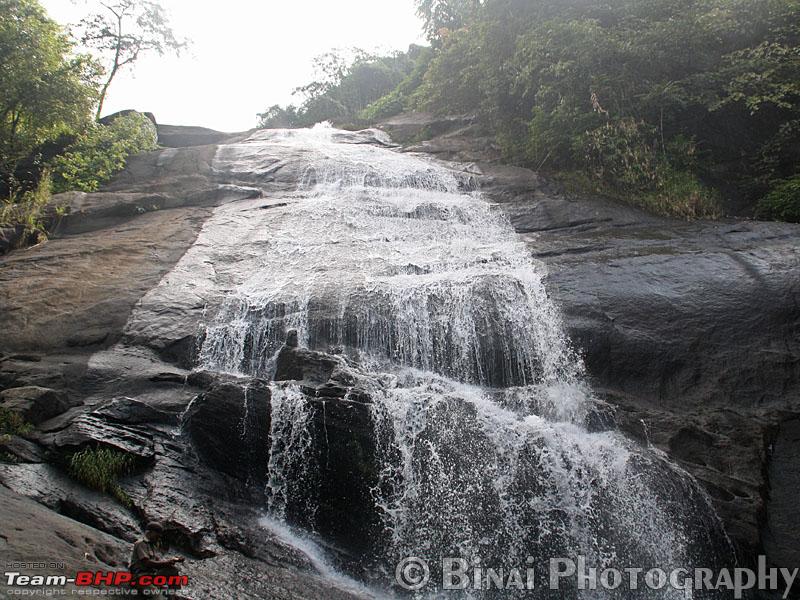 The first falls as seen from its base. After spending some time at the falls, we headed towards Kalpetta. We started from Thusharagiri at 10:52. (Trip: 214.5 kms) Just while driving back from Thusharagiri, I missed a turn towards Adivaram. Did not want to go back, and hence continued on the same route that I came in from Thamarassery. From Thamarassery, took a right and continued towards Kalpetta. Our progress was very slow once the ghats began - I stopped where ever there was place to park the car, and it was photos all the time. The road was not as bad as being told, but was not in great shape. The potholes weren't blunt - my car was easily going in and coming out.  "Welcome to Wayanad" There were lots of people standing around the arch that welcomes one to Wayanad district. All this while, I was thinking that the Thamarassery ghats was in Wayanad District - this trip was an eyeopener for sure. The next place on my radar was Pookod Lake. I missed the "Chain Tree" - noticed the point just after crossing it. Did not want to turn back - so continued to Pookod. Reaching Pookod lake was very easy - the route was well marked. We stopped right outside the ticket counter - I had no idea of where the lake was, and drove a bit ahead. Only to realise that the entry to the lake was right next to the ticket counter. Parked the car, and walked back to the entrance. Reached Pookod at 1250 (Trip: 267.7kms)  Pookod Lake The entry is small, and is guarded by volunteers of the Vana Samrakshana Samithi (VSS). There is a Gandhigram stall as well. We spent some time at Pookod lake - none of us were interested in a boat ride. We just walked around the boating camp - admired the flowers in the park nearby. The lake had lots of Water Lilies (the blue ones). I am a fan of such water plants, and we spend a lot of time watching them and taking some photos. We did some shopping at the Gandhigram stalls in the park - Tea and some spices. By now, all of us were hungry - so lunch was next on the cards. We started from Pookod at 13:22. I was planning to stop at Kalpetta for Lunch - had remembered reading "Woodlands" as a decent place, so this place was on my cards. A while after Pookod Lake, noticed a resort/restaurant - "Chembra Heritage" on the right side of the Road. It was basically a homestay, with a restaurant at the front. The restaurant had some visitors when we reached there. We had veg meals for lunch - It was a typical Kerala style meal. The service was very slow. It took them almost 10 minutes to serve a second helping of the dishes - and it took them forever to refill water! But the food was too good - they charged Rs. 75 per head though. Just as we were finishing meals, it started pouring down heavily. The rain was very heavy - so we waited for a few minutes to see if weakens down. Since the rain continued in full flow, we decided to start off. Started off at 1415hrs (Trip: 279.2 kms). Visibility was very poor and hence we had to crawl for quite some time. I made a wrong turn inside Kalpetta - but thankfully realised it soon and came back to the actual route. The turn to Mananthavady is well marked, and its after Kalpetta Town. The roads from Kalpetta to Mananthavady is excellent for about 70% of the distance, and average to bad in the other stretches. On reaching Mananthavady town, my aim was to visit Pazhassiraja Tomb. Getting to this place was confusing - I lost my way and almost landed up back at the Kalpetta/Panamaram-Mananthavady road. Then asked a tea stall guy, and got the actual route. There were no boards to identify the correct route. For people going there for the first time, ask for the "Government Hospital" at Mananthavady. Just as you reach the Government hospital, there is a narrow steep road taking off to the right - you land right outside Pazhassi Raja Tomb.  Pazhassi Raja Tomb We reached Pazhassi Tomb at 1525hrs (Trip: 318.0 Kms). There is no entry fees to go to Pazhassi Raja Tomb - you need a walk a bit (may be 50 metres or so) from the parking to the tomb. There is a museum below the tomb. When we reached, there was no power and hence the entire museum was dark - no lights were working. So we could not see any of the displays, and we just walked out of the museum. Took some photos and rushed out - the clouds were looming low, and it got dark. A while after starting off from there, another downpour started. We had to stop a while after starting from the town to ask for directions. A rick guy said "Take a left after the next city" - City?? The roads from Mananthavady to Kattikulam (the "next city") was decent - good in places, and bad in patches. Kattikulam is a small town - it has two fuel stations. Just as we exist Kattikulam, there is a RTO Checkpost. Right after this check-post, one has to take a left to head to Thirunelli/Tholpetty/Kutta. The straight road goes to Bavali.   Kattikulam Check Post. Take left for Thirunelli/Tholpetty. Go straight for Bavali/HD Kote. The road is in great shape after Kattikulam - its a well paved and well marked two lane road with light traffic. The road runs through "Wayanad Wildlife Sanctuary". A few kms after Kattikulam, one would cross the offices of the Range officer and their quarters. A while after crossing these offices, we reach a Y shaped junction. The road to the left goes to Thirunelli and the one to the right heads to Tholpetty. We took the left turn.  Take a left at this junction for Thirunelly, and right for Tholpetty.  My car at the junction.  Elephants have right of way! On the Way to Thirunelli  The Road to Thirunelli The road gets bad after this turn - both sides of the road is lined by Bamboo and Eucalyptus trees. Bamboo had flowered earlier last year and hence they all had dried up and had mostly collapsed. The road condition varied from Bad to Worst. As we approach Thirunelly, the road gets better (not excellent). The turn to our stay - KTDC Tamarind Easy Hotel - was well marked. It is about 0.5kms before the temple.  The Approach to KTDC Tamarind Easy Hotel. The property on the left is Agraharam Cottages, and the one on the right is Brahmagiri Homes. There were three properties one next to the other - Agraharam Cottages, KTDC Tamarind Easy Hotel and Himagiri Homes. The last one did not appear functional. When we reached Tamarind (1638 hrs), there was just one more car. I had reserved my rooms earlier and had paid advance money as well - just showed the receipts to the Manager. They insist on seeing a proof of identity, and also collect a copy of the same. The hotel has some 10 AC rooms and two Non-AC Dormitories - one does not need an AC room in the place, but we are given no other choice.  This is the KTDC Easy Hotel. The welcome was warm - the manager-cum-receptionist took care of my baggage, and carried it to the room himself. Our room was on the first floor. The hotel has a restaurant - however, food is available only on prior order. In case you would be checking in to the room late, let them know in advance if you want dinner. Same for breakfast - they take orders the previous night itself. As we checked in, we asked for tea and then relaxed until about 5 in the evening. Later, we all freshened up and headed to the temple. There is one horrible patch of road a while before the temple. The reach to the temple is steep. There is a decent car parking outside the temple. We had darshan at the temple and returned to the room that evening. The evening was spent watching TV and relaxing. We had ordered dinner at the restaurant there. Dinner was ready by 2030hrs and we headed to the restaurant for dinner. By now, the hotel had a few cars and a tempo traveller - a casual chat with the manager revealed that they have decent occupancy throughout the year, although they have no kind of publicity! Dinner consisted of freshly made Chappathis and a Veg curry - the food was yummy. Just as we returned after dinner, an extra mattress was delivered to the room along with bedsheets, pillow and blanket! The staff at Tamarind were awesome - they quickly responded to requests, and they came to the room to ask if we needed anything else. After the yummy dinner, we retired for the night. At the end of Day, the Odo read: 46639 kms (Trip: 352.2 kms). It took 11 hours to run 352.2 kms, including all breaks - quite a decent run! Last edited by binaiks : 23rd November 2011 at 18:49. |

|  (2)
Thanks (2)
Thanks
|
| The following 2 BHPians Thank binaiks for this useful post: | CliffHanger, Voodooblaster |
|
23rd November 2011, 18:54
| #2 |
| Team-BHP Support  | Re: Wayanad and Coorg in Three days Mods note: Thread moved to right section. Thanks for sharing. |
|
| ()
Thanks
|
|
23rd November 2011, 19:06
| #3 |
| Senior - BHPian Join Date: Nov 2005 Location: KL-47 // KL-53
Posts: 1,830
Thanked: 1,164 Times
| Re: Wayanad and Coorg in Three days Some random pics from Day 1 (Could not add them to the earlier post due to limitations):  The roads between Thamarassery and Adivaram.  A monkey family at the Watch Point - just past the last hair-pin bend on Thamarassery Ghats  Hairpin bends seen from the watch point.  Welcome to Pookod!  A lone guy meditating on top of the ticket counter at Pookod!  A Row boat at Pookod.  Water Lilies at Pookod  The Boat landing at Pookod. |
|
| (2)
Thanks
|
| The following 2 BHPians Thank binaiks for this useful post: | CliffHanger, Voodooblaster |
|
23rd November 2011, 23:11
| #4 |
| Senior - BHPian | Re: Wayanad and Coorg in Three days Nice clicks, does the hotel have any view or its just forest cover which you see from the rooms? How far away from main Kalpetta? |
|
| ()
Thanks
|
|
24th November 2011, 13:44
| #7 |
| BHPian Join Date: Mar 2010 Location: Bangalore
Posts: 406
Thanked: 97 Times
| Re: Wayanad and Coorg in Three days Hi Binai, Nice pictures of greenery + rain. What will be the best approach route to KTDC Thirunelly if we are coming from Mysore side? |
|
| ()
Thanks
|
|
24th November 2011, 17:46
| #8 |
| BHPian Join Date: Sep 2007 Location: Hyderabad
Posts: 306
Thanked: 742 Times
| Re: Wayanad and Coorg in Three days Awesome pics sir! I have been to Wayanad 3 years back and most of your pics brought back fond memories! Did you visit Edakkal caves and Banasura dam? These are wonderful places to visit! Cheers, Saleem. |
|
| ()
Thanks
|
|
24th November 2011, 19:36
| #9 | |||||
| Senior - BHPian Join Date: Nov 2005 Location: KL-47 // KL-53
Posts: 1,830
Thanked: 1,164 Times
| Re: Wayanad and Coorg in Three days Quote:
Quote:
Quote:
Quote:
Quote:
| |||||
|
| (1)
Thanks
|

| The following BHPian Thanks binaiks for this useful post: | Voodooblaster |
|
25th November 2011, 17:51
| #10 |
| Senior - BHPian Join Date: Nov 2005 Location: KL-47 // KL-53
Posts: 1,830
Thanked: 1,164 Times
| Re: Wayanad and Coorg in Three days Here I continue with Day-2: Day 02, November 07, 2011: Odo: 48639 Trip: 352.2kms Route Covered: Thirunelli-Kattikulam-Tholpetty-Kutta-Virajpet-Gonikoppa-Kushalnagar-Bylakuppe-Madikeri  This was what I saw in the morning... It was one really deep sleep. I woke up around 6AM, to see my dad sitting near the window. The scene outside the heavenly low flying clouds and paddy fields! We had ordered morning tea the previous night that was duly served by 7.30AM. We started off for the temple by around 8 AM. The temple parking was hell crowded the guys manning the parking had a unique logic. They let Tourist vehicles (the commercial ones) to part right outside the temple and asked private vehicles to park far away! Finally found some place to park and we headed straight to the temple. Since I had darshan the previous day, I did not go inside the temple but reserved the time for some photography. One has to pay Rs. 25 for photography at the temple (they collect this money towards renovation fund). I went about clicking madly around the temple. Spent almost 30 minutes photographing at the temple we did not visit Papanasini. Had breakfast at a temple right outside the temple and headed back to Tamarind.     This is the path used to bring water from a nearby spring. There is some history associated with this water supply.  These stone works are mostly being brought down and replaced with mundane cement works. Once back at Tamarind, we packed out baggage and checked out. The Final bill (including dinner, extra bed and taxes on these) came to about Rs. 2300 (Rs. 1400 was paid as advance). Since we were running a bit low on fuel (had just over quarter tank remaining), I asked the guy at the reception if there was a fuel station around Kutta he said there is one, but that is unreliable. Its better to head back to Kattikulam and refuel, was his advice. We started off from Tamarind at 0956hrs. (Trip: 354.9). I enjoyed the run through the forest it was clear and sunny, unlike the heavy rains we encountered on our inbound. The road were not in great shape, but was still good. 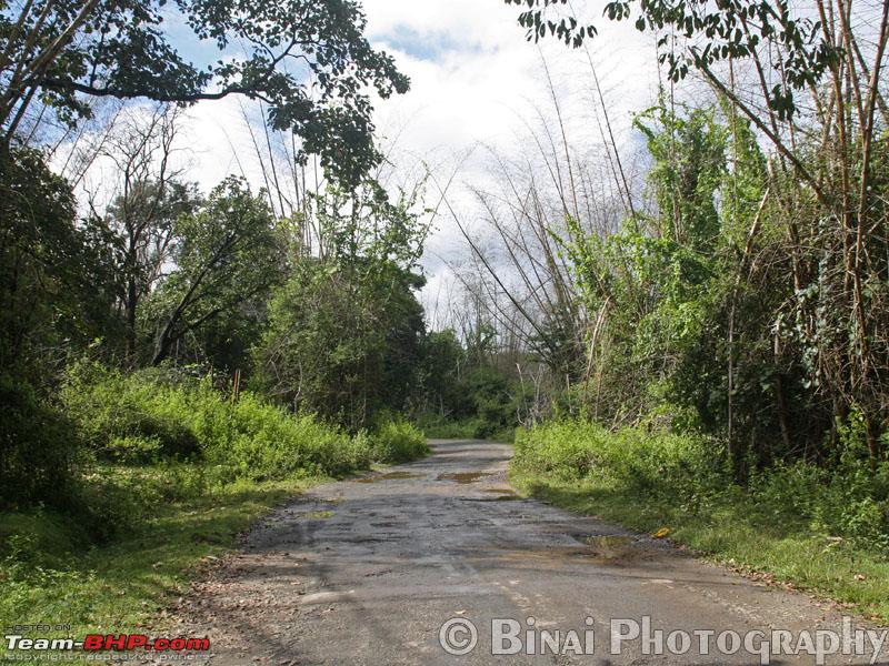 On the way from Thirunelly to Kattikulam.  Notice the collapsed Bamboos in the background - they had flowered earlier this year. We pulled over at the first fuel station but Lo! The diesel pumps werent working. The guy there said there is another pump just 50m ahead, towards Mananthavady. This pump was bigger than the one that we went in earlier. The attendants were in no mood to attend out vehicle it took them over 5 minutes to come. After topping up, we started off towards Tholpetty. (Left Kattikulam at 1046, Trip: 375.9kms). The roads from here on are in awesome shape they are well marked and well laid. I was in no mood to race, and hence we ran through at about 50~60kmph. It was cool outside and hence we kept the windows open slowing down every time we saw something. The fun part was that even Autos overtook me at some places! I slowed down at Tholpetty but the place was horribly crowded and hence we decided not to stop. The roads are in great shape all the way upto Kutta. The moment you cross over into Karnataka, the roads turn from Good to Bad to Worse to Worst. You just cross a hump at the border, and you land straight into potholes! We crossed into Karnataka at 1108 hrs. The roads were in really bad shape after Kutta, and hence the progress was really slow. The road was barely a lane wide, and one had to go off road if another vehicle comes in the opposite direction.  We exit from Kerala..  The checkpost in Karnataka limits - the road gets worse after the hump you see in the image.  This is the state of road after Kutta  A Narrow bridge after Kutta  Poor roads continue.. The roads were lined on either sides with coffee estates their boundaries were well marked, and it was a very good sight. We reached Gonikoppa at 1230 (Trip: 431.0). It took us close to 2 hours to cover just 55 kms! (The first 17 kms took only over 20 mins) We did not find any decent restaurants around, and hence decided to look for one around Virajpet. We continued towards Virajpet from Gonikoppa. Virajpet too disappointed us, and he continued towards Kushalnagar (Via Siddhapura). The roads in this section too werent great, but were better than all the stretches we did till then. The roads were deserted for most of the distance no decent hotels anywhere. We went past Siddhapura, still without lunch. We had packed some fruits and some other stuff from home, which kept us going. Finally we reach the Mysore-Madikeri State Highway, and take a right towards Kushalnagar.  Somewhere near Gonikoppa We finally find a decent looking hotel right opposite Kaveri Nisargadhama. I forgot the name of this place the service was laidback but the food was awesome. After a sumptuous lunch, we decided to head to the Golden Temple at Bylakuppe. The guy at the hotels cash told us which way to proceed we started off from the hotel at 1507 (Trip 490.1 kms). We reach Kushalnagar and ask a cop for the way ahead despite the clear instructions he gave, we still managed to miss the turn and we ran a few kms towards Mysore. We stopped again and asked at a small hotel, and then turned back. Finally, we get back to track and we reached Golden Temple at 1528 hrs (Trip 500.1 kms)  Entry into "Nyingmpa Monastry" - Golden Temple lies inside.  Public are not allowed into this temple.  This temple is open to public  These idols are made of copper, and coated in Gold. This brings the name "Golden Temple". The Tibetian Settlement at Bylakuppe was a different world in itself It was one really calm place. We visited the temple that is open to public a prayer was in progress at the smaller hall nearby. Our visit was very short, since I was in a bit of hurry to reach Madikeri before sunset. We started off from Golden Temple at 1551 hrs.  The road towards Madikeri. The road from Kushalnagar to Madikeri is a breeze (except the last few kms around Madikeri town). We decided to see Gaddige first, and started asking directions for the same there were absolutely no markings anywhere and this was really disappointing. I was disappointed when we reached Gaddige the area was fully dug up and completely deserted. We just saw the structures from the car, and decided to carry on.  "Gaddige" - this is the tomb of the erstwhile ruler of Madikeri. Next on the list was Abbey Falls. The narrow roads on the way confused me a bit if I lost my way something but, Just as I feel I lost my way, Id see a signboard to confirm that I was on the correct route. The road was narrow, twisty and in poor shape at places. As we neared Abbey Falls, saw a lot of vehicles coming the opposite direction. You reach a point from where only light vehicles are allowed you need to pay Rs. 20 here. The roads after this get really narrow and there are quite a lot of tight curves. We left the car at the parking, and headed straight towards the falls. My mom was a bit apprehensive of walking down nevertheless we continued. The falls were really good not too huge, not too small. My mom was disappointed on not being allowed to get into water but we certainly respect safety. We took some photographs, and started our return to Madikeri as it started getting dark. We started off at 1733 (Trip: 544.5 kms).  The way to Abbey falls - its a short 10 minute walk from the parking to the falls. There is enough number of benches for those who want to take a break from walking.  An information board on Abbey Falls - The board says that the falls is also called as "Mutharmuttu" Falls. The falls is 21.3m wide. Abbi means "water fall" in Kodavatak. The falls was called "Jessy Waterfalls" by the British. 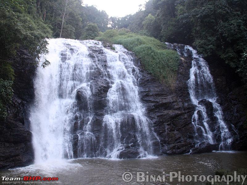 This is the falls.   One last look at the falls as we return One the return journey back towards Madikeri, there was one White Santro, whos driver had his hands on the horn he was honking continuously all the time. The road was so narrow and there was no way I could let him go ahead but this bugger kept using the horn all the time. He got off my back just as we neared the town centre. Our next place was Raja Seat I missed the turn to Raja Seat, and I ended up taking the turn towards Mangalore. Had to turn back and then head to Raja Seat. Getting a parking place at Raja seat was difficult being a holiday, people were out in hordes. There were a couple of tourist bus from my place (School kids from Government Higher Secondary School, Kodungallur) as well. Our visit to Raja Seat was really short the place was very crowded and it was getting cold. The sun had already set, and my wish to capture sun-set there was unfulfilled.  A view of the valley from Raja Seat.  Raja Seat We now started off at 1814 (Trip: 553.8 kms) it was really dark now. Our rooms were booked at Prashanti Resort, which is about 5kms from Madikeri on the Mangalore route. The resort serves only Vegetarian food, and does not allow consumption of Liquor its a good place to be in, if you are visiting with Family. The initial few kms from Madikeri was awful there was absolutely no road, and it was pitch dark around. Vehicles in the opposite direction being adamant of not using low beam complicated matters further. We called up the resort guy and took down directions to his place. It was exactly 5 kms from the point where you turn off towards Mangalore from Madikeri. There was a huge board outside the place which helped us reach there. We called up the resort guy, who sent his guy to pick us from the parking. We reached there at 1832 (Trip: 559.4 kms) The resort is set on a 10-acre property they have 5 cottages in all. All cottages have Televisions and they had Dish TV Connections as well. We asked them if they provide dinner they said yes. Veg Thali was served around 2030 hrs at the room freshly cooked food. The dinner was awesome. A while after Dinner, they brought the extra mattress that we had asked for. By 2130, all of us had hit the bed. At the end of Day, the Odo read: 48846 kms (Trip: 559.4 kms). We travelled 207.2 kms over the day 8 hours and 32 minutes on the road. But the poor roads made for a tiresome journey, though. |
|
| (1)
Thanks
|
| The following BHPian Thanks binaiks for this useful post: | Voodooblaster |
|
25th November 2011, 20:30
| #11 |
| Senior - BHPian | Re: Wayanad and Coorg in Three days Nice pictures and trip report Binai  . Its been a while since I visited these places. Thanks a lot for refreshing my memory. . Its been a while since I visited these places. Thanks a lot for refreshing my memory. The Kutta-Gonikoppa road was bad ever since I remember. You could have taken the Kutta-Nagarhole-Hunsur-Kushalnagar route instead of the Gonikoppa route. On the way, you could have maybe taken the safari at Nagarhole. The roads are in good condition too. It might have been an extra 10-15 kms, but the roads were very good. |
|
| ()
Thanks
|
| |
|
26th November 2011, 16:43
| #12 |
| Senior - BHPian Join Date: Apr 2010 Location: Palakkad/Coimbatore
Posts: 1,229
Thanked: 1,105 Times
| Re: Wayanad and Coorg in Three days Nice write up and photos. Info on KTDC Tamarind,Tirunelly was an eye opener You did not try the unniappams at Jungle view hotel at the Tholpetty-Tirunelly fork? Best ever I've had |
|
| ()
Thanks
|
|