Team-BHP
(
https://www.team-bhp.com/forum/)
-
Travelogues
(
https://www.team-bhp.com/forum/travelogues/)
Quote:
Originally Posted by vinukm
(Post 3260916)
Nice Travelogue and pics as well. Wondering if my Figo can negotiate the roads there? I am sometimes worried because of low ground clearance.
|
Yes it surely can. I have seen many cars around that place, which have ground clearance even lesser than that of the Figo. So you should be just fine.
"Gaalikere, Mullayanagiri and Bababudangiri - All in one shot" is one terrific shot, one of the best I have seen recently.
Fantastic photographs to say the least, this writeup is growing to be a very interesting one.
The Safari compliments the landscapes so well, post more please.
Awesome photos of the hill stations around chickmagalur. Have been to chickmagalur a few times but never got an opportunity to visit those mountain peaks. Definitely, a place to rejuvenate and unwind yourself and this has been on my tourist list. Not sure when I would be making the trip..
Cheers!!!
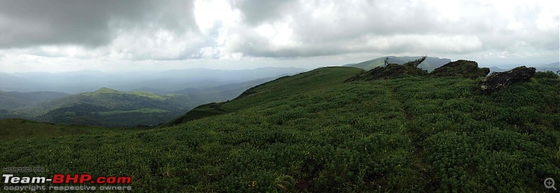
A few panorama shots - Photos just cant do any justice after all !
The road from Seetalayyanagiri to the top of Mullayanagiri
View from Mullayanagiri, looking north

The western crest near Gaalikere

Looking west towards the bowl of the "C"
Quote:
Originally Posted by Nagesh
(Post 3258105)
Great pics Raghunandanj!! I have been to Kemmangundi several times, but had never heard of this place.. on my agenda next. Any other interesting spots you visited around this place?
Thanks for sharing.
|
Apologies for the late reply, I inadvertently missed your question. But better late than never, so here is my answer to your question :
There are many interesting places around this section of the Western Ghats, and it is imperative that all visitors respect the sanctity of these places by not littering them :
Places around Kemmangundi :
Z Point - Hike
Upper Hebbe Falls - Hike ( Need a local guide )
Lower Hebbe Falls - 4X4 ride + Hike
Paalu Mane - Hike ( permit needed )
Top of Kallathi Falls - Hike ( Need a local guide )
Places around Bababudangiri :
Gaalikere - Easy Drive
Gaalikere to Paalumane - Hike ( permit needed )
Manikyadhaara Falls - Easy Drive( high tourist footfall )
Devirammana Betta - Hike
Mullayanagiri - Hike or Drive ( high tourist footfall )
Places around Muthodi :
Shigekan IB Viewpoint - 4X4 only
Bandekallu Gudda - Hike
Kavikalmata Viewpoint - Hike
A superb set of photos, enjoyed viewing each one of them. Thanks for sharing.
In fact the map of the Bababudangiri range with the marked extent of BTR along with the four ranges is the best of the lot for me. The photos of Gaalikere brought back memories of a trek I did in 1997 with three of my friends from Bababudangiri/Dattatreya Peeth to Kemmangundi, past Gaalikere. We never made it to Kemmangundi since we lost our way but reached Santaveri on the Tarikere - Chikmagalur road the next morning! In those days there was no road anywhere near Gaalikere, so looks like things have "improved".
Views from Shigekhan IB are supposed to be great as well, but of course one needs a 4x4 to reach it or walk to it.
Quote:
Originally Posted by raghunandanj
(Post 3253997)
So here begins another photologue dedicated to the beauty of the Western Ghats. If anyone can add information on the other major peaks of the area, the locations of Gangegiri, Hebbegiri, and the names used for the bowl-like region they encompass, I would appreciate it.
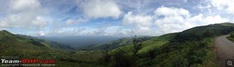
Gaalikere, Mullayanagiri and Bababudangiri - All in one shot Attachment 1146546
|
Superb pictures Raghunandan:thumbs up. The shot of Gaalikere, Bababudangiri & Mullayanagiri is fantastic to say the least. I really did not know you could cover all the three in one shot. I was really surprised to see clear skies during this time of the year. You were very lucky in that sense. Everytime I have been to this place, it was always foggy. I haven't even seen the full lake clearly even though I've been there a few times. And the lake looks very clean in your pictures:D. Thanks a lot for posting these.
Regarding the peaks, I have heard of one place called Hogarekhangiri at the outer edge (Eastern side) of the flipped C. It is supposed to be located somewhere near Santaveri, IIRC on the Santaveri-Birur road.
The inner part of the C is also called as Jaagara valley. In fact Bhadra Wildlife Sanctuary was called as Jaagara valley Wildlife Sanctuary earlier. Jaagara is a small village on the Attigundi-Muthodi route.
I had a topographic map of this area. Let me see if I can find it and check for any new names on it.
Quote:
Originally Posted by addyhemmige
(Post 3266330)
Superb pictures Raghunandan:thumbs up. The shot of Gaalikere, Bababudangiri & Mullayanagiri is fantastic to say the least. I really did not know you could cover all the three in one shot. I was really surprised to see clear skies during this time of the year. You were very lucky in that sense. Everytime I have been to this place, it was always foggy. I haven't even seen the full lake clearly even though I've been there a few times. And the lake looks very clean in your pictures:D. Thanks a lot for posting these.
Regarding the peaks, I have heard of one place called Hogarekhangiri at the outer edge (Eastern side) of the flipped C. It is supposed to be located somewhere near Santaveri, IIRC on the Santaveri-Birur road.
The inner part of the C is also called as Jaagara valley. In fact Bhadra Wildlife Sanctuary was called as Jaagara valley Wildlife Sanctuary earlier. Jaagara is a small village on the Attigundi-Muthodi route.
I had a topographic map of this area. Let me see if I can find it and check for any new names on it.
|
Thanks a lot addy, I had read many of your travelogues on this part of the world and was waiting for your thoughts.
I had heard of the name Jaagara valley at JLR Bhadra at Lakkavalli,and thought it might be the valley submerged under the Bhadra reservoir. Thanks for the clarification.
I am rather keen to know more about this place, so any info you can provide will be truly helpful. The area around Muthodi, Khandya, and the submerged areas of NR Pura are places I want to explore the next time.
Did you happen to know a mountain by name Gangegiri around this place ?
Quote:
Originally Posted by raghunandanj
(Post 3266594)
I am rather keen to know more about this place, so any info you can provide will be truly helpful. The area around Muthodi, Khandya, and the submerged areas of NR Pura are places I want to explore the next time.
Did you happen to know a mountain by name Gangegiri around this place ?
|
Actually, even I haven't explored this area fully. The road from Muthodi to Balehonnur/Khandya is supposed to be very scenic (and in bad condition:D).
Haven't heard of Gangegiri, but will check in the maps and let you know.
Wow!! Wonderful pictures!!! Western Ghats after rains is enchantingly beautiful and we can see that through your pictures. Thanks for sharing. Not less than 5 starsclap:. Keep it coming.
Nice pics :)
Have driven my figo to the Mullayangiri peak, man what a drive.
Probably the scariest drive I have ever done.
Definitely a must visit place, if you like travelling. Also babbudan giri is also close by.
Both are beautiful places, very misty, so need to be careful while driving.
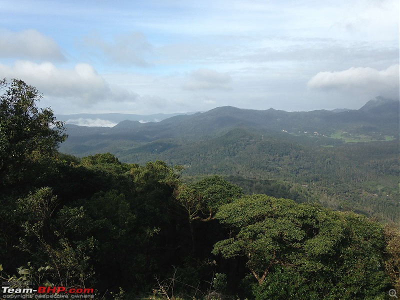
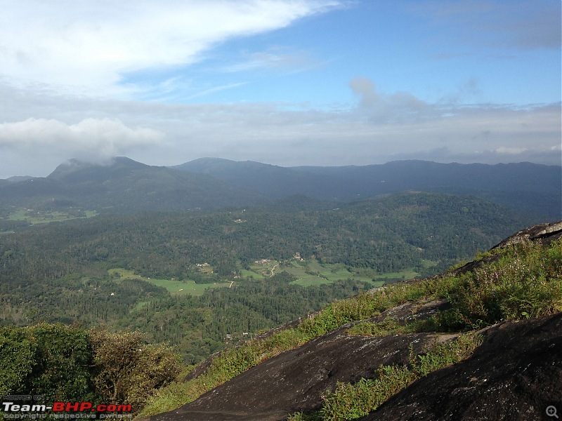
Exploring the southern fringes of the Jaagara valley east of Chikmagalur towards Muthodi, I chanced upon another travelogue that provided useful information on hiking trails around the Mallandur area, in close proximity to Muthodi. "Bande Kallu Gudda" seemed an interesting hike, so we drove from Chikmagalur at 7:30 AM, parked the beast near the coffee plantations and began the hike around 8:00 AM. Initially, the road turned into a steep gully-eroded jeep track and gained significant elevation within a km of distance, to end in a clearing on the shoulder of the Bandekallu hillock. This stretch is indeed inviting for hard-core off-roaders, and old Willys jeep was trudging along the distance when we were hiking. Beyond the clearing, which itself is an excellent campsite overlooking the estates below, is a narrow path snaking into the shaded undergrowth. The fact that this path was rarely hiked had evidence in the foliage cover almost hiding the walking trail from view. Beyond a 100 metres or so emerged the exposed slick rock that we had to ascend to enjoy splendid views of the countryside. The ascent was quick and quite easy, and the howling winds at the top added a faint aroma to the atmosphere.
Looking north, we could the see the lower portion of the Jaagara valley, with all its giants, Mullayanagiri, Seethalayyanagiri, Mallandur-Muthodi road, the fringes of the Jagara valley, and faintly on the horizon, the silohuette of the upper arm of the Jaagara Valley, that being the Hebbegiri range.
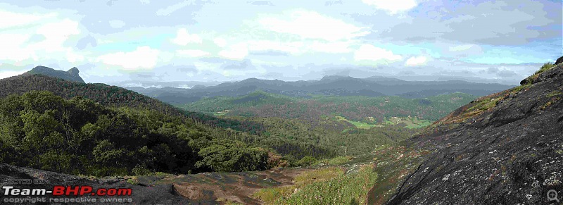
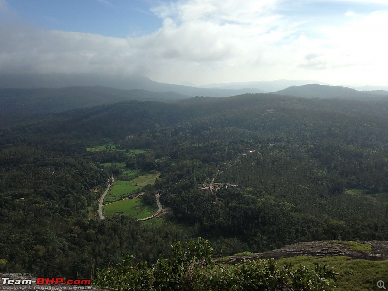
Looking east, the plains of Chikmagalur were basking in the morning sun, and the western areas towards Khandya and the surrounding country were slowly waking up from the shadows of the hills, with the clouds lifting into view. However, it was not these sights that hooked me, but the view when I saw southward.
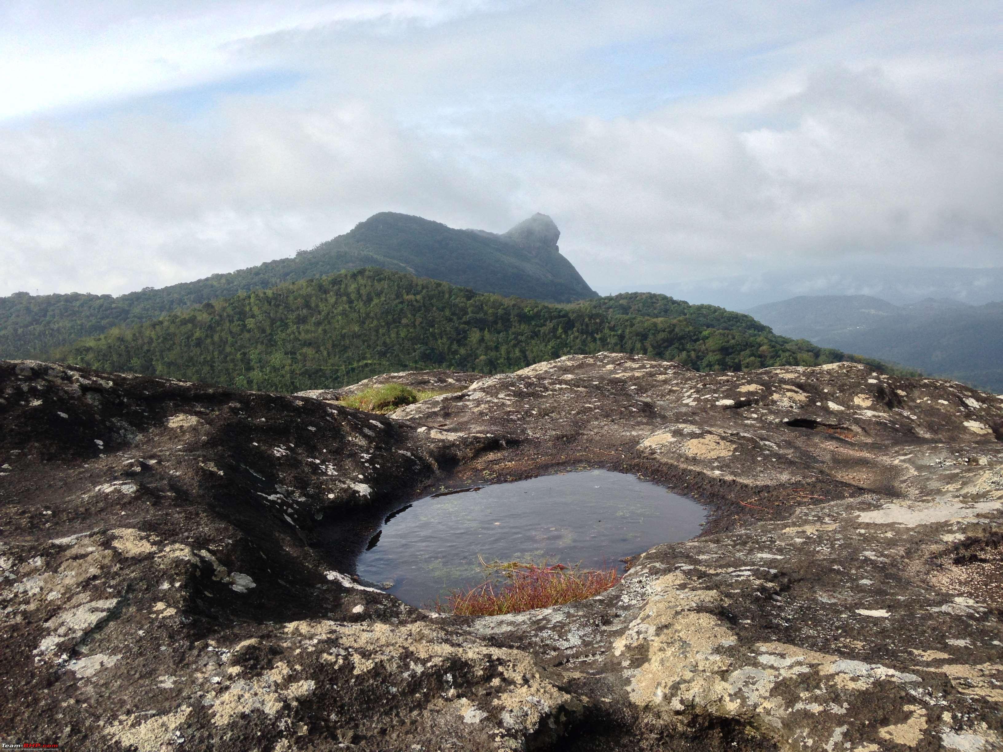
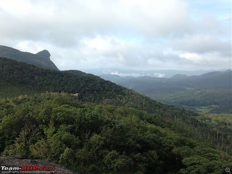
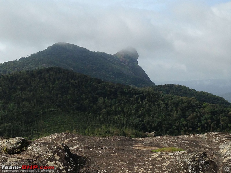
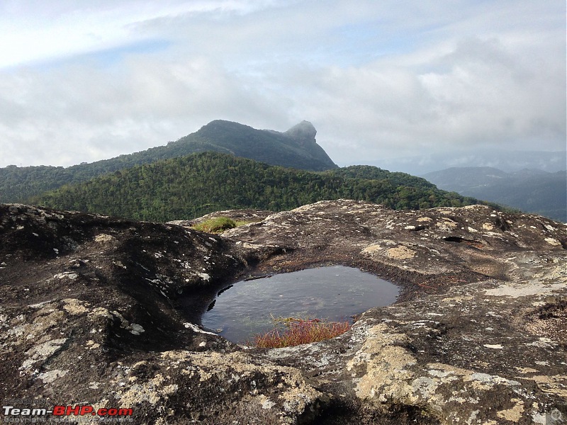
Looking towards the south from the summit of Bande Kallu, a strange sight caught my attention. For a moment, it was as if I was transported to the time when I was reading Phantom comics as a kid, wherein a mountain with the head of the phantom, called "Phantomhead", was a prominent feature in the stories. This one however, was not the Phantomhead of fiction, but a distinctively head-shaped mountain that was probably the closest thing to the Phantomhead that I have ever seen. The locals call it "Maadalakallu Gudda" and apparently it has never been climbed till date. Nevertheless, here was the Phantomhead of Malnad. There are no religious or local beliefs that restrict the access to this place, but no one has ever tried cutting through the undergrowth to create a trail.So the Phantomhead of Malnad still awaits its first hiker!
Looking South West
Looking North West
The Western Panorama
The Phantomhead - Maadalakallu Gudda
Looking North from the Summit of Bande Kallu

The Southern Ranges of the Jaagara Valley from the Summit

Looking East in the morning sunshine
The Phantomhead up close - Anyone willing to go ?
Looking South
Finally, I have found out the actual name of this mountain range, which assumes the form of the "flipped C", and the name is "Chandra Drona Hill Range".
The range is called Chandra Drona Range due to the distinctive shape that resembled the crescent moon.
Post deleted by the Team-BHP Support : Please do NOT post messages that add little or no informational value to the thread. We need your co-operation to maintain the quality of this forum.
Please read our rules before proceeding any further. We request you to post ONLY when you have something substantial to add to a discussion.
Hey Raghu, excellent travelogue. Am planning a visit to Chikmagalur in January. Will be driving there in my xuv FWD. Do you think I will be able to do the Mullyanagiri to Kemmanagundi road/trail as seen on Google maps, in the vehicle with family? Or do you advise against.
| All times are GMT +5.5. The time now is 22:04. | |