Team-BHP
(
https://www.team-bhp.com/forum/)
-
Travelogues
(
https://www.team-bhp.com/forum/travelogues/)
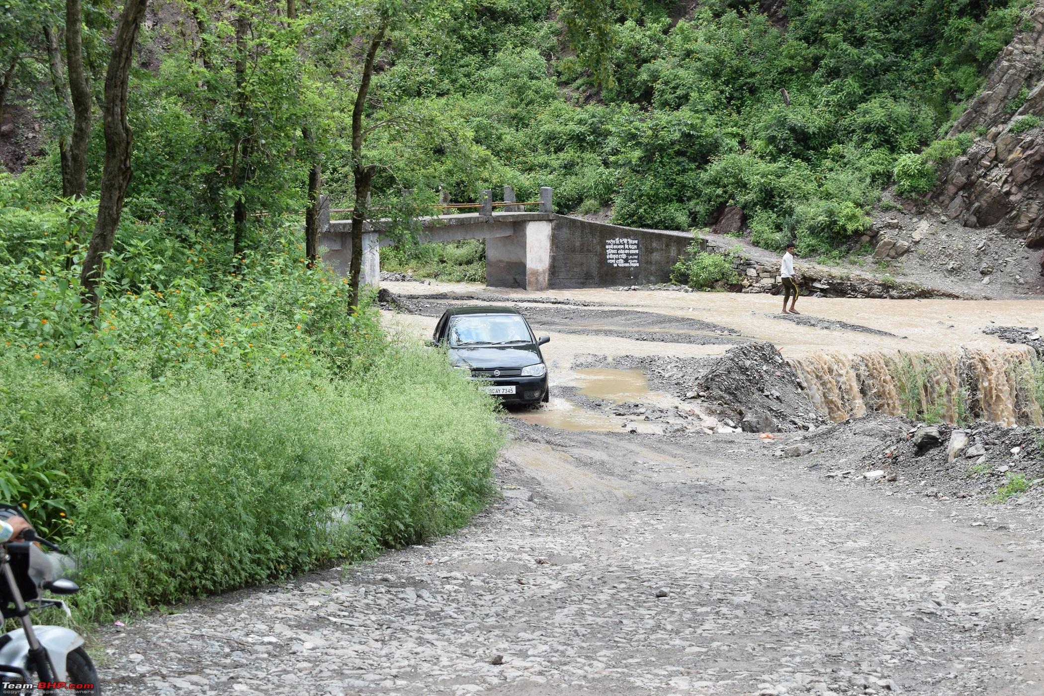
I just chanced upon this thread and the MMI and the Googled had me fooled this weekend itself. While driving from Shri Renuka Jee to Paonta Sahib the route was shown from Dadhau to Birla via Jalal Bridge. I took it only to realise that those 8 kms were pur off road fun. here are the picture of what we drove through
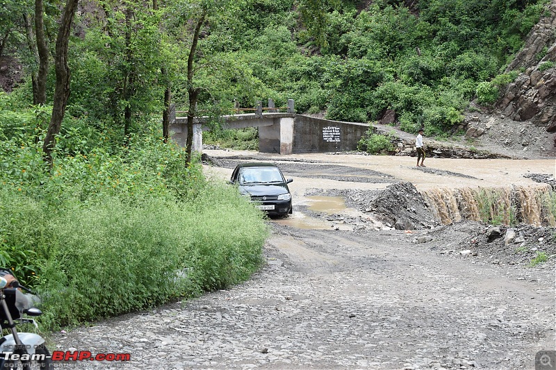
and finally reached the main road at Birla.
I took have been a victim. While on a recent trip to munnar, Google baba suggested a shortcut which was supposed to save my time by a whopping 35 minutes. I decided to give it a try.
What followed was a torturous one hour of grueling mud,slush rainy,downhill drive on a narrow, non existent path, with rocks on one side and a sharp drop to heaven on the other. At one such sharp turn, i gave up. I couldn't see the left tyre which was very near the precipice, and the car wouldn't reverse on the slope. A few tries is all it took to convince me that any further attempts from a novice on such roads would send the car barreling down. I asked my wife to get out and was planning to leave the car there and call for help.
Lucking a Jeep was rambling down the same road. The God sent fellow took reins, placed rocks in front of the wheels, burned the clutch for sometime and guided the car to safety.
I have a short 10 minute dashcam footage. If you are adverse to songs, please mute. The voice has been overwritten to protect the sensitivities of viewers from the thousands of expletives hurled at Google. Also please excuse the low 360p quality.
https://www.youtube.com/watch?v=-goB2dwHG24
Most of you have spoken my words here. So I will not narrate my similar experiences here, but, will continue what happened to me in next few trips and probable solution.
After Google maps mis-led me several times, I thought the problem would be reduced(Did not expect to be solved anyways) if I use Map my India as second GPS and navigator.
But, Instead of problem getting reduced, it doubled(My perception). What happens usually is, I will install MMI on my dashboard and my brother(We usually go on family trip only) holds Mobile with Google Maps ON (This is only on less travelled roads. Not on standard roads)
While going straight, Suddenly GMaps would instruct me to turn Left while MMI would suggest to go straight. I would be in dilemma whether should I follow MMI or Google Maps?
Will toss and follow Google (The main assumption here is, since google gets updated very often compared MMI, I will hope sincerely, google will have some better road.) After following for few KMs, Google will raise the hands in the mid of nowhere but, it will still hope that I will still follow Google Map only. But, having lost the hope on Google, I will pray MMI to help.
Now, MMI will ask me to go back for few tens of kilometers to take revenge on me for not listening to MMI a while ago.
Then, once I return to the point where MMI asked me to go Straight, MMI will start guiding me for another 10-15 kms and then, it will show its true face and raise hands.
Now, I would be fed up of both MMI and Google. So, start searching for God's messengers(Local people). Most of the times, I have experienced, that God's messengers will ask to go back much beyond (In return) the first point where Google Maps asked to take turn and take a right or left to reach my destination.
Conclusion: After multiple such experiences (On less travelled roads only) I have named Google Map as Numerologist and MMI as astrologist
So, when we are traveling in such roads and whenever there is a difference of opinion between numerologist and astrologer, we will go with God's messenger words :)
Google is doing a great job of documenting and converting our haphazard, undocumented roadways into navigation map. Google should take this further and indicate whether roads can be traversed by cars or bike. I guess it should be simple, given that Google can measure the road width in satellite maps. I also wonder why Google isn’t able to distinguish between tarmac and slush roads? I am sure Google can do so much better but isn’t doing it.
At times G MAPS take you to less ventured and beautiful places, It happened with me as well, Me and my roommates decided to go to Bhimashankar.
We have visited the temple and all went well, on the way back we decided to check G Maps, and we were able to see Bhimashankar wildlife sanctuary, we were surprised and wanted to take that route.
Unfortunately, Rather fortunately , we have hit the no mans land(That's what we felt).The landscapes are so beautiful. we spent the rest of the day clicking the snaps.
Attaching few snaps that i have access to at the moment, will upload the best ones when ever i could access the snaps
Quote:
Originally Posted by GTO
(Post 4234357)
Thread moved from the Assembly Line to Travelogues. Thanks for sharing!
Great story. Google Maps can mess things up sometimes - always better to take local intelligence (i.e. ask someone) in remote areas. This is the bridge Google Maps wanted me to cross on a recent trip in Goa rl:.
It does work like a charm 99% of the time (I prefer it over any car's onboard navigation); however, those 1% of times do provide for some amusement or frustration (depending what mood you're in).
...
|
I am guessing this was Agonda? Google Maps showed me the same route. Had to back track a couple of kilometers to find a road that my car would actually fit on.
Funnily though, it shows this route because most of the locals take the route with their WagonRs and Omnis.
Google maps can sometimes behave like your finicky girl-friend, really don't know what she is up to :D, its best to stick with asking locals for directions.
But there is a trick, before you take on the road suggested, you can switch the maps to 'terrain' mode (if mobile data is available) where it shows the satellite view of the terrain, zoom in and get an idea of the width of the road and the terrain nearby (village/dense forest etc) and then proceed.
For all the bashing that its getting, somewhere I think we all acknowledge its one of the best resources available to us. More often than not, g maps gets us to the remotest of locations:D
When one signs up for using Google Maps, as part of the document where one selects "I agree" are statements such as these...
"While you use Google Maps / Google Earth's map data, traffic, directions and other Content, you may find that actual conditions differ from the map results and Content, so exercise your independent judgement and use Google Maps/Google Earth at your own risk. You're responsible at all times for your conduct and its consequences".
I tend to believe that every other such product has such clauses that absolve them of any consequences.
Hence, if one wants to use Google Maps (or similar), we are doing so at our own risk.
However, in the whole process, I suppose we get to see some parts of the country that we didn't know existed and experiences thereof would help a conversation at some time : )
Quote:
Originally Posted by joshuakeys
(Post 4235285)
At times G MAPS take you to less ventured and beautiful places, It happened with me as well, Me and my roommates decided to go to Bhimashankar.
We have visited the temple and all went well, on the way back we decided to check G Maps, and we were able to see Bhimashankar wildlife sanctuary, we were surprised and wanted to take that route.
Unfortunately, Rather fortunately , we have hit the no mans land(That's what we felt).The landscapes are so beautiful.
|
Is that SH54 / Talegarh road? I mean you had to take a sharp right turn while returning back from Bhimashankar? That is a very nice scenic road and a shortcut too. I often take that road.
Hehe, again in Munnar, GoogleGod once took me down a tiny tea estate trail which was just about wide enough for my Octavia! My family totally enjoyed the drive but our host (homestay owner) freaked out when he heard it because that particular 5 km is considered too dangerous and almost impassable except by an experienced estate driver in a Mahindra jeep
Had gotten horribly lost during my honeymoon while driving from Ooty to Kodaikanal. Thanks to Google uncle, we went to a ghat which was desolate, bad roads, and practically no mobile network. The time was almost 2-3 hours so you can imagine how scary it was.
Later the hotel told us about the alternate route and I cursed the maps to no end. Being on my honeymoon, I couldn't show my fright but upon discussions later, we both were seriously scared and had a good hindsight laugh about it.
There are 2 issues with using any satellite based navigation devices:
1. They are approximate. GPS signals have a built-in error. It can be on any axis. Only US military gets decoders without errors. So they approximate using the location signals of the nearest cell phone towers. When you are moving, they extrapolate and put you on the road or rail track, depending on your movement.
2. They are dependent on the maps provided by state PWDs. Survey of India has got much more accurate maps but they are never current. People who have used Topo sheets would know this. Many of the mistakes can be attributed to corruption in the road constructing authorities. Finishing certificates are granted and road category changed on paper but the reality is something else. Software algorithm tries to take you on the best category road as much as possible eg NH, then SH and then MDRs.
In addition to Bhimashankar Wild life sanctuary trip, The following weekend we planned to visit Koyna, The room bookings were done, Rooms were booked near the Koyna River and it belongs to my friend.
We have stopped at Mahabaleshwar to click some snaps and the weather was so good that ended up staying there till 4pm, then we have asked Google chacha to guide us and the google chach made us drive till 9PM and there is no sight of any car or any lights, It was pitch dark every where on those hilly Ghats.
No phone network, around 10:30PM, we could see some human habitat and asked for the Hotel name that we booked, they directed us to the Hotel, When we were ought to check in, The manager told us that we have come to wrong location, the booking that we have done was on the other side of the Koyna and its about 80Kms away. I called up my friend he was like do not drive here at this odd hour and stay back there and you can come in the morning.
We asked the manager if we can check in,he said the rooms are all booked and he cannot let us stay there.
We have checked rest of the village and found out a good camping place for 700 bucks per person and that includes Dinner and breakfast for the next morning.
We did not realize that it was such a beautiful place until it was morning, the place where we stayed is exactly on the river bank near the DAM.
Surprisingly when we checked the google maps in the morning it showed that we are near the KOYNA wild life sanctuary :eek:
When we asked the SUPER at the comping hotel, He said yes the sanctuary is close by, but its open post monsoon. Then he showed the packages, it included the kayaking, river rafting, Trekking .
Attaching the pics from the phone which i have.
So we thanked google for taking such places which is less explored.
Quote:
Originally Posted by PetrolRider
(Post 4235383)
Is that SH54 / Talegarh road? I mean you had to take a sharp right turn while returning back from Bhimashankar? That is a very nice scenic road and a shortcut too. I often take that road.
|
I am sure i have take a steep right but not sure if the road you are talking about is the same that i have taken, I remember pimpari as one of the location on the way, that road took us to steep ghats the roads are good however they looked like they were never used for long time. Is it the same you were talking about?
Man that road took us to mesmerizing locations, It was exactly in Aug last year. have plans to get lost again this year to that location :D . will make a note of the maps and locations this time :)
Cheers
Josh
| All times are GMT +5.5. The time now is 07:17. | |
 and finally reached the main road at Birla.