| |||||||

| Search Forums |
| Advanced Search |
| Go to Page... |
 |
| Search this Thread |  8,579 views |
 5th December 2009, 07:17
| #1 |
| Newbie Join Date: Sep 2009 Location: Palampur
Posts: 20
Thanked: Once
| Journey through the Dhauladhars and back Before anything else, the planned route. And before the planned route, a word on my new found allergy to plans. Plans are not fun, plans are predictable, plans are dull, plans make me weary and plans spoil all plans.  Planned route: Dharamshala-Indrahar Pass-Kuvarasi-Lamu. Planned time 5 days. I had been on part of this trail back in June 2003, after graduating. At the time, it had only been a 1 night trek and I had figured there was a pass up in the clouds which leads to a better world. This trek had been on my radar ever since. This was the first real trek. While real trek is a subjective phrase and all treks are actually real, let me tell you what constitutes a real trek in my book.
I started planning this in August and the plan was to do it starting 20th August but then a combination of angry weather gods and my unsuccessful itch to generate a cash flow while being out of a regular job, interfered. |

|  ()
Thanks ()
Thanks
 |
| |
|
5th December 2009, 08:33
| #2 |
| Newbie Join Date: Sep 2009 Location: Palampur
Posts: 20
Thanked: Once
| A bit of a digression. I was planning this follow up post much earlier than it has come, just got entangled with reading a site. If you are a cricket fan, you must read cricket with balls - join sehwagology. If you are a Sehwag fan, dont call yourself a Sehwag fan if you dont read this. Back to the Dhauladhars now. Day 1 begins Have you ever wondered looking at a snow capped mountain what lies behind it? At least I did that last time I was in Triund. I went with a friend, Tripat Gulati and he was floored reaching Triund. My apologies to him for the not so flattering reference here but he first refused to buy a 10 Rupee cup of tea on the way citing its expensiveness and then ended up buying one for 20 rupees further up when the going got tough. The view of the snow capped Dhauladhars (धौलाधार) from Triund stuck in my mind since then. We started from a little below Galu Temple (गलू मंदिर) at around half past 12. Ruck sack loaded to the brim, surrounded by thick fog, walking in an Oak jungle, I was apprehensive about my ability to complete my first 'real trek'. This was the first time I was to cross a pass on foot and the highest altitude I have ever been to. To top that, I was unable to get any AMS (Acute Mountain Sickness) medicine, just in case it was needed. I have always remembered the trek up to Triund as a strenuous one, probably because of the memories of Mr. Gulati's hardships. I was wrong. The first part is extremely easy, which explains the number of casual and unprepared visitors Triund receives. We had a break half way at one of the temporary shacks called Magic View. The first meal on the trek consisted of exorbitant bread and omelette. Exorbitant considering normal standards but once you take into consideration that a mule has to carry the bread and eggs all the way up, it does not pain that much.  Forest Rest House Triund - Caretaker Quarters Forest Rest House Triund - Caretaker QuartersOn the way, we passed some of the day trekkers coming back from Triund. Each, even the Indians who would not bother looking at you if you crossed them in the town, said 'Hi' as they passed me. Do the mountains teach courtesy? Or are we just plain lonely in the mountains? There was this last stretch of the trail leading up to Triund where the slope is very steep, the curves very sharp and the breath very short. Just before we started on this stretch, Suresh mentioned that there are 22 curves to Triund. I counted only 19 and then asked Suresh if 22 was a mind game to make me feel better. He however denied it and said I must have made a counting mistake. We reached Triund at 3:30 PM, just 3 and a half hours after we had started. Triund has never been a settlement, just a trekking destination. Located at an elevation of 2842 Metres above sea level, it was a holiday destination for the British as well. I had a room booked in the Forest Rest House for the night. This rest house, built during the British era had changed a lot since I last came to Triund in June 2003. A separate small structure had been added to serve as the toilets for the 4 rooms and most importantly, there was a running water supply.  Sunset at Triund Sunset at TriundIn the earlier days, you had to walk down around 2 km to a stream to get water, even for basic necessities or buy a bottle of mineral water for 30 Rupees. The sky cleared up in beautiful shades in the evening and the snow clad mountains of June 2003 were bare, huge, beautiful rocks in September 2009. With clouds visible and the sun setting in distance over the Kangra valley, it was a sight to behold. It was photography time. I have been learning the basics of camera e.g. exposure, ISO settings and aperture etc. So, I had the opportunity to apply whatever little I have managed to grab. I must have taken at least 50 photographs of the sky; long exposures, dark photos, high depth of field, what not! And all this without a tripod. All flat surfaces were my tripods, including but not limited to window sills, door frames, even and uneven rocks. Well, and the results showed. Photos taken with such dedication turned out to be disappointments with slight blurs marring their beauty. The day ended with an unsuccessful attempt at geocaching some 1.5 km from Triund and a icy cold water bath direct from the tap in the bathroom. Geocaching caught my fancy around a month ago and I realized that there were geocaches hidden around Triund as well. The one I went for was along a ridge 1.5 km from Triund. I used my newly purchased Garmin eTrex Vista Hcx for zeroing in on the supposed location of the not found geocache. I intend to hide geocaches myself in the coming treks just to make it even more fun for the people who walk the trail. |
|
| ()
Thanks
|
|
5th December 2009, 11:37
| #3 |
| Newbie Join Date: Sep 2009 Location: Palampur
Posts: 20
Thanked: Once
| Day 2 was to start with a walk towards Lahesh Caves at half past 9 in the morning. We were also to await a couple of foreigners who were going the same way with Jango, Suresh's cousin, as their guide. The morning was beautiful with a full sun shining and lighting up the grassy slopes of Triund. Photo time again!! Having had an early breakfast, we set off earlier than planned and were out of Triund at quarter to 9. With clouds hovering over Dharamshala in the distance, there was talk about the weather and whether it would allow us to cross the pass. It is usually considered safe to cross high mountain passes before noon because they tend to get stormy later. I am not sure if it was a coincidence but there is a small rock doubling up as a temple at the exact spot where the trail crosses 3000 metres, dedicated to Tirange wali mata (तिरंगे वाली माता) and Suresh prayed at the spot for clear weather and an even crossing of the pass. The first stop on this day was Snowline Cafe. It is last place on the trail where you can buy water, chocolates, biscuits and other stuff to eat.Since this place is a good 5 hour walk from the nearest road, needless to say, these things cost quite a bit more than they would at Dharamshala. So, you would be best advised to carry everything you need from Dharamshala. Snowline cafe was thus named because till some years ago, the snowline was just above the cafe at Laka (लाका) glacier and the mountains above were snow clad around the year.  Dinner time at Lahesh Caves Dinner time at Lahesh Caves A Dhauladhar peak from Triund A Dhauladhar peak from TriundHowever, the effect of global warming is clearly visible now and you can see the snow line has receded beyond the mountain range, hence the bare, rocky mountains. From Triund, the trail climbs almost up to 3150 Metres and then goes down to around 3050 Metres at Snowline Cafe. Once it leaves Snowline Cafe, it meanders up and down up to Laka, which once had a glacier and now has broken remnants of a Forest Rest House. As soon as the trail crosses the leftover stream of Laka Glacier, it slopes steeply upwards. You can see the Lahesh Caves in some distance and it does not look like more than 20 minutes away. The walk is almost 2 hours however. Every few minutes you glance at the caves and realize they are still as far as they were when you started. The reason is twofold; the rocks and mountains are much larger than they look to the naked eye from a distance, so you underestimate the distance. Additionally, the slope is steep and the only way to negotiate it without killing your legs is a tortoise like slow and steady zig-zag walk to reduce the effect of the slope. If you try walking straight up, you will actually take longer because you will need many more rests. We made good time on this part of the trail because we just stopped once between Snowline Cafe and the caves. At just after noon, we were at the Lahesh Caves. Lahesh is a natural shelter formed of a large piece of rock bending over the earth (a rock overhang, so to say) at an altitude of 3474 Metres above the mean sea level. The ceiling of the room thus formed is between 2 and 4.5 feet high. The entrance faces the Laka Glacier and is 4.5 feet high. The roof of the cave slopes back to 2 feet at the other end. Over the years, shepherds and trekkers have filled some of the gaps left by nature to form a warm enclosure. Just outside is another large rock which is perfect for using as a verandah or as an open sitting room and see the sun set. It was very foggy when we reached Lahesh.  Gavin and Patrick looking to the heavens Gavin and Patrick looking to the heavensHowever, gradually the fog cleared and it was again a beautiful evening. Around 3, we were joined by Gavin and Patrick, 23 from US and 28 from UK respectively, who were on the same trail, the same people we were waiting for the last evening. With the 6 of us now occupying the abode that Lahesh was, complete with the resplendent sitting room, open toilets and a beautiful waterfall with a stream a few metres away, it was party time.  Sunset from Lahesh. Delicious!! Sunset from Lahesh. Delicious!!There was tea with lots of sugar, biscuits, an evening snack comprising of khichdi, some rum to ward off the cold and a dinner of rice and dal. The meals were plain but really enjoyable in the surroundings and after the fatigue of a tough climb. It was again photography time between 4 and 7 with the clouds, the sky, the rocks, the mountains and Gavin and Patrick being my subjects. Along with the evening tea, each of us talked about our apprehensions about the next day's climb to the pass. From Lahesh Caves, the pass was almost 900 metres higher. However, it looked much closer than that. It also looked insurmountable with its rocky, bare and craggy faces. There was no place we could see where you would put a foot for walking. The top looked like a single vertical rock. While I did not admit it then, it did give me a chill. Like the good old human race, we were in bed at 7:30 pm. What business do humans have being out in the open once the sun has set and it is dark? Nothing, so they go to sleep in their sleeping bags laid out on the mats. I had an allergic cold and was unable sleep for a long time, the rare air at that height making it difficult to breathe sufficiently deeply from just an open mouth. So, a D'Cold came to my rescue and I slept in fits after 10:30 pm. However, while gulping the D'Cold, I picked up a bottle of water in the dark only to realize that it was a bottle of kerosene after drinking from it. Lesson: When sleeping in a cave, keep your torch with you. One night at Lahesh and you understand why cave men used caves. They are warm and safe. Lay some grass down, add a mat, put your sleeping bag and your bed is almost as comfortable as home. |
|
| ()
Thanks
|
|
5th December 2009, 18:14
| #4 |
| Senior - BHPian | Nice one. I did the route alebit a bit differently way back in 1994. Have heard the things have changed for the better now with a lot of walkers meeting you going both ways. In those times you hardly got anything enroute. |
|
| ()
Thanks
|
|
5th December 2009, 18:57
| #6 |
| Newbie Join Date: Sep 2009 Location: Palampur
Posts: 20
Thanked: Once
| Day 3 This was The Day. The day when we would cross the pass, the day we would be at the highest point on the trail, the day breathing could become difficult, the day we would walk the most and longest, the day Kangra (कांगड़ा) would end and Chamba (चम्बा) would begin. It was all rolled into one the biggest day of the trek. Fittingly, it began early. We were out of our beds at half past 5 intending to leave by half past 6. Between various people answering nature's calls and having a forced breakfast for strength to cross the pass, it ended up being quarter to 7 when we started. The climb had both looked short and tough on the previous day from our vantage point. However, when it began, it turned out to be long, it turned out to be tough, it turned out to be breathless at times and it turned out to be fun and challenging. It is on a climb like this that you realize the value of being a group. At various points during the climb, different individuals take the ownership of keeping the group's energy going. It could be small things like ensuring the group rests as often as the slowest person needs it or ensuring each person has water and some chocolate or candies at breaks to build up strength, but they matter a lot in ensuring the group stays together and good time is made. I never figured how long was the trail up to the pass and I am not even interested. It could be just a kilometre for all I care. All I know is it took us 3 and ½ hours and every bit of energy each of us could spare to climb to the pass. More often than not, we were climbing at some sort of steps which were less than 6 inches wide and more than 1 and ½ feet high. The act of balancing our huge and heavy ruck sacks on our backs on these tortuous slopes was almost like a circus balancing act. The fact that there was a gap of over 2 hours in between me taking photographs on the trail is to me testimony to the fact how strenuous the trail was.   On the way up, we stopped just after we crossed over 4000 metres. It is a place called Ghandu ki Hain (घंडू की हैण), a stream which takes melted snow down to the watershed of the Beas river. During April June, when this part of the trail is still under snow, the climb is through Ghandu ki Hain. It is much steeper but faster and needs trekkers to use crampons on their shoes to keep the grip. Sometimes, even ropes are used to climb up. Just when you think it cant get more tiring, steeper and strenuous, it does. The last half an hour was the toughest. Once we reached the top though, it was every bit and more worth than any trouble we took. A clear blue sky, views on both sides; the Pir Panjal (पीर पंजाल) ranges, Mani Mahesh (मणी महेश) peak and passes of Lahaul Spiti (लाहौल और स्पीति) on one side and the valleys of Kangra on the other. There are no words which can do justice to the feeling of having achieved that climb and fewer which can do justice to the views from the pass and that off looking down upon most of the clouds. I felt this was the high point, both literally and scenically. Gavin, who had been carrying a guitar all this while (Hats off to him for that, Hail Gavin), making the guitar bag double up as a suitcase played some fantastic guitar and sang some songs for us at the top. I am not sure if that was the case but this could well have been the highest ever concert by a guitarist. The trouble of carrying the guitar to this point was well worth it for Gavin and was a pleasure for the rest of us.  While I enjoyed the way up and scenery from the pass, a mountain pass can be a very tough and dangerous enemy in inclement weather. There have been injuries and deaths around the pass in the earlier years, partly because of excessive risk taking and mostly because weather gods decided to play foul. Up at the pass, there is a memorial plaque to Arvind, Bhanu and Surya of the Bikaner Adventure Society, who lost their lives somewhere close to the pass in 1986. Here is a salute to the human spirit of adventure and to these three! After having appreciated the views and Gavin's guitar, we set off down the other side of the pass. If you asked me, I would have wanted to be perched there forever but our guides were having none of it and they wanted to reach a safe altitude before 3 PM. While the sky was clear, a little wind can blow clouds close to the pass and it can snow in no time.  It is on the Chamba side of the pass that you appreciate the need of a guide on this trail. Up to the pass, the trail is crudely way-marked with some red painted arrows and it is not really difficult to find your way. However, once you cross the pass and go down a few metres, there are no markings and you can see the beginnings of a way at multiple places. Even if you know the exact location of the spot you want to go to, you will be able to see multiple paths leading down. This is not to discourage the adventurers from venturing alone, just a word of caution so you are prepared for the hardships the trail can throw your way should you decide to travel without a guide. The descent on the other side is steep for a 150 metres and you reach a relatively plain ground after that. This is a strict no-no for camping overnight. Not only is it extremely cold, the air is thin and it can get really windy in the evening. There have been casualties in this part of the pass earlier. Further from this plain ground, towards north west is Sukh Dali (सुख डली). I noticed most lakes in the area end with the name Dal or Dali. Sukh Dali is known as such because it was a lake at some point and has dried now, hence the name Sukh Dali, Sukh for dry and Dali for lake. It is a slow long curved depression littered with rocks, presumably the lake bed. At this time, there was some fresh snow on the pass and Sukh Dali as well. A small digression; if you walk along the ridge after Sukh Dali towards the West for an hour and half, you can reach Nag Dal (नाग डल), which is a holy lake. The area is around 1 square km and the lake is fresh water. It is considered a sacred Nag abode and is hence a Shiva (शिव) abode as well. All the mountains around have one or the other Shiva incarnation as the local god. I did not have the opportunity to go to Nag Dal but I have heard it is an amazing sight and the one regret I will have from this trip is having gone so far, I was unable to see Nag Dal. A foreigner tried to float a rubber dinghy in the lake a couple of years ago and it started thundering and snowing immediately along with a storm and the guy had to evacuate immediately a la Fredalo. Locals believe it was the retribution of the Nag devta (देवता) for using a holy lake in an inappropriate manner.  Just below Sukh Dali, our groups separated out because we were walking at different paces, with us ahead and Gavin, Patrick and Jango almost 250 metres behind us. I had heard Jango and Suresh discuss accommodation for the night. They spoke Gaadi, language of the Chamba Gaddis, which I had struggled to understand at all on the first day but was now starting to get comfortable with. They were concerned about how to split the groups since the caves we were headed to could not harbour 6 people. To my surprise, a few minutes later, I noticed the other group had changed direction and was headed slightly East towards some Gaddi (गद्दी) shelters erected for seasonal use by the nomadic Gaddis shepherding their herds. We continued our way down a treacherous slope which passed a stream. Just before the stream, we had to walk on a rock at a very steep angle with footholds blasted into the rock. Pyare Lal mentioned the foot holds had been blasted into the rock by his great grandmother. While the rock does offer good grip because of a rough surface, the gradient and the fast stream below do shake your confidence.  With your heavy ruck sack on the back which seems much heavier after 5 hours of walking on rough trail, this can get tricky. With your heavy ruck sack on the back which seems much heavier after 5 hours of walking on rough trail, this can get tricky.A further 1 hour walk below are the Chata Caves at an altitude of 3275 metres. Chata is actually a Goth (गोठ), the local word for a shepherd halt. Gaddi shepherds with their goat and sheep herds travel from Chamba to Kangra valley over the Indrahar pass for the winters and back for the summers. Since this trail is frequented by Chamba shepherds, the shelters often show signs of recent use. We were lucky to find some shrub and dried wood right in front of the cave and used them to light a camp-fire, which lasted most of the evening. Similar to Lahesh in being a rock overhang, Chata Cave is smaller, lower and warmer. It can hold 3 sleeping bags with ease and 4 will be pushing it too much. The ceiling is so small that after kneeling and crouching, a man my height (barely 5' 4) banged his head quite a few times. You do not get out the cave, you crawl out with a reptilian wave of your body. We were concerned about Jango, Patrick and Gavin since Suresh had reason to believe that the shepherd shelter they were headed for may no longer be there and it could get quite cold at the altitude they were staying at. We noticed a fire on the Western face of the mountain the evening and realized they had switched shelter for the night. A flash of torch from either side worked as communication that everything was fine up there. Night's fare consisted of soupy, spicy noodles, the perfect concoction to make you feel good and energized after a day of strenuous trekking followed by a tea. Ended up taking another D'Cold as soon as I reached because of heaviness in the head, probably because of the high altitude and the lack of oxygen at Indrahar. |
|
| ()
Thanks
|
|
6th December 2009, 11:13
| #7 |
| Newbie Join Date: Sep 2009 Location: Palampur
Posts: 20
Thanked: Once
| Day 4 An early morning day, for I wanted to take some shots of the pass from this side. Early morning revealed that the Chamba side of the pass looks like a huge rock piece. The feeling you get is that the mountain right from the pass down to the Chata Caves is a full 1 km high single rock. I am pretty sure that is not the case but that's the impression is gives and it is quite an impressive impression. Sunrises and sunsets are not as good from a photography point of view from this side because of the high mountains. We waited for Gavin, Patrick and Jango till half past 9 just to check if they would join us by the time. Just after 9:30, we set off for Kuvarasi without them. The trail winds up and down through numerous waterfalls and streams. When we started, I was using my GPS to mark water sources for future trekkers but stopped doing that once I realized there is one almost every 15 minutes of the walk. If you are walking this trail, don't ever bother taking water with you. Not only will you be carrying useless weight, you will also miss the experience of drinking direct from the best mineral water sources nature offers you. The cool, fresh mountain water has a taste quite different from the cheap imitations we get. The biodiversity of this side is striking.  Looking back up at the Indrahar Looking back up at the IndraharThe jungles are greener as I mentioned earlier, they also have variety. Some way below the pass, I saw some shrubs and bushes which were unique to this side. If you draw a vegetation map of both sides of the pass, the difference in vegetation would be clearly visible. The Chamba side of the pass is clearly more unrelenting. The slopes and hence the gorges are steeper and deeper, the mountains appear higher and they also appear smoother and grip-less. The other aspect different about the Chamba Dhauladhars is they clearly look untouched and unspoilt, the jungles are greener and pristine, the tree line is higher, the snow line is lower, wildlife abounds in the form of brown bear, wild goat and leopards. There are clear marks of the brown bear at work at various points trying to pull out plants it feeds on. The slopes also harbour small natural shelters for these animals. I think the more prosperous and tourist scoured Kangra valley pays the price for being a popular destination.  Thick Deodar forests in Chamba Thick Deodar forests in ChambaThe shrubs and bushes you see on this side, just to name a few, comprise of Saraingad (सरैंगड़) and Salpada (सलपड़ा), in addition to highly combustible Bathar (बठर); so combustible are the leaves and woody stems that they burn fresh, no need to dry. Salpada is a seasonal, thin fleshy stemmed shrub, yellowish green in colour, which grows as high as 6 feet during the rainy season. Suresh told me that it sometimes gets difficult to sight humans during the rainy season treks. As soon as the rainy season gets over and the October heat sets in, they give a burnt, dried and dead appearance and fall off. Another striking feature of the vegetation was pine trees. As soon as the tree line starts on this side at around 3100 metres (much higher than the other side), there are pines all around. Pines usually grow between altitudes of 1000 metres to 1600 metres. This is the first time I saw any at such high altitudes, which are normally reserved for other conifers like Deodar (दयोदार, Cedrus Deodara) and Firs. The pines here are such high quality that their wood is considered as strong for construction as Deodars. Around an hour from Chata caves, up the slope, on the ridge is the temple of Langari Mata (लंगारी माता). There is an interesting story surrounding the origin of this temple. Ages ago, there was a village girl in the area who started living with a local shepherd and herding his sheep. She lived with him for 12 years without ever contemplating marriage. It is said the society was not as constricted and narrow minded as it is today. At the end of 12 years, she suddenly realized that perhaps living with a shepherd unmarried for so long was not the best thing to do and she said: [FONT=Tahoma]बारह साल चारी लंगारी[/FONT], [FONT=Tahoma]तेई न सोची भ्योरी न सोची रही कुंवारी[/FONT]  Crossing and Balancing Crossing and Balancingand then jumped into a stream to give her life. The phrase means 'Twelve years we shepherded sheep on the Langari ridge, neither you, nor I thought of me and our marriage.' Thence, the legend of the Langari Mata was born. For locals, the goddess is very sacred and is supposed to protect their herds from wild animals. Within a certain perimeter of the temple, nothing hurts their herds. However, if within the same perimeter, a shepherd utters an obscenity, he pays a heavy price. Someone playing cards in the area once uttered an expletive and died the same night as lightning struck him and most of his herd. The trail goes up North and down the slope for almost 3 hours and then reaches the stream which it follows since crossing the Indrahar pass. The crossing of this Ravi (रावी) tributary is on a small makeshift wooden log bridge adjacent to a recent landslide. This was another common feature, the landslides. It does not take much to guess what has caused these. The good thing is though you can see quite a bit of new plantation in the area.  Mandhara Grasslands Mandhara GrasslandsWith the ban on green felling in Himachal and the new plantations, you suddenly feel it may not be so difficult to preserve nature here. However, as always, there are issues with execution of the laws and apparently smugglers operate in the area. Quite how extensive is the smuggling, I have no clue but it does exist. Half way through the walk to Kuvarasi, around 3 hours from the Chata Caves, across the stream, the trail reaches Mandhara Goth (मंधारा गोठ), another of those stops for shepherds. There are quite a few caves and since the elevation is much lower compared to Lahesh or Chata, the place is much warmer and greener. Mandhara is on a flat piece of rolling grassland surrounded by forests with a few trickles of spring water flowing through, a perfect place for an overnight stay. By the time the trail crosses Mandhara, the vegetation changes to Deodars. The Deodars are simply huge. Ones with a stem diameter of 1.5 metres are common, those with 2.5-3 metres can be easily seen. Occasionally, if you strain hard enough, you will see even bigger ones. The amount of wood each can produce is simply humongous, no wonder smugglers take the risks they do. Some are big enough to yield enough wood for constructing an average sized house. Then there are those with roots on a vertical slope, the stem coming out horizontally, perpendicular to the slope and then the entire stem turns up towards the sun. I was amazed to see the craving for life even a supposedly almost lifeless plant possesses. To exist and thrive on a slope like that quite a testimony for desiring to live. At half past 3, after a 6 hour up and down walk through rich jungles and lots of waterfalls, we reached Kuvarasi, where I ended up staying for 2 days. |
|
| ()
Thanks
|
|
7th December 2009, 19:27
| #8 |
| BHPian Join Date: May 2007 Location: UP 16
Posts: 936
Thanked: 159 Times
| That sure is one helluva journey. Reading this log is making me feel like quitting everything and heading to the mountains for a real trek.  |
|
| ()
Thanks
|
|
14th December 2009, 12:10
| #9 |
| Newbie Join Date: Sep 2009 Location: Palampur
Posts: 20
Thanked: Once
| Day 5 A few metres gained in altitude for answering nature's call in the open and the same few metres lost on the way back. That and a bath at a communal tap along with lots of lazing around with some sumptuous and humongous meals is what would summarize my first rest day at Kuvarasi. I stayed the night at Suresh's ancestral place. The wooden house was constructed by his granddad. There was no consensus on the age of the house. Suresh said 50 years and Jango later said it was 100 years old. Let us live with 50 for the time being. Constructed out of Deodar wood, these mountain houses are as strong as they come. Deodar wood has a long life, does not rot with water, is not infected by insects and is easy for woodwork. You really cannot ask much more from a construction material. The amount of engineering and trussing skill that goes into making them is no joke and to think that someone has had this skill for ages now is quite amazing. Kuvarasi is a Gaddi village located in District Chamba. 14 km and 4 hours walk from the nearest road head in Lamu (लामू). I was unable to ascertain the history of the village. Estimates of the settlement's age varied between 200-1000 years. However, there was consensus on the fact that settlers came from the nearby Bharmour (भरमौर) region. The village is located such that it receives the maximum possible sunlight. The sun rises early at 7:30 am and sets around 5:00 pm. The village may be remote but it does have Dish TV, the one with 'Wish Karo, Dish Karo' tagline and satellite phones provided by BSNL in many households, along with the usual electricity lines and water taps. The central attraction of the village is the Nag Temple at the top of the village and the huge Deodar tree just above the temple. A Deodar to dwarf all I had seen till now. The temple is understandably sacred for the area and has a natural water spring. It is said the spring's source is in the Nag Dal lake. This came to light many years ago when a rich shepherd from Kurasi, bathing in the Nag Dal lost one of his two huge golden ear rings in the lake.  He immediately said 'What will I do with just one ear ring?' and immediately took off the other and threw it into the lake as an offering to the Nag Devta. When he came back to the village, he visited the Nag Temple and started to drink from the spring in the temple. Sure enough, both the rings came out with the water right into his hands. He immediately said 'What will I do with just one ear ring?' and immediately took off the other and threw it into the lake as an offering to the Nag Devta. When he came back to the village, he visited the Nag Temple and started to drink from the spring in the temple. Sure enough, both the rings came out with the water right into his hands.Most people in the village have land holdings and some have herds too. There are quite a few who have migrated to other places like Suresh and Jango and then there are others who are employed elsewhere. Villagers cultivate the usual mountain cash crops like Rajmah, potatoes and walnuts in addition to the usual cereal crops like wheat and Syul (used for making an offering to Shiva during Shivratri). Apples are a recent addition and there are some new apple trees to be seen. Now comes the best part of the entire story. Everything grown in this village is organic. Everything means everything and completely absolutely. No fertilizers, no pesticides, no insecticides, only cow dung and a fresh taste. I was amazed to know that there are still places in the world, not so far away from where the doyens of civilization live which are still uncorrupted to this extent. It was by far the most pleasant surprise on the trek. Sure enough, the organic produce does taste different and differently better. Since the area is not commercialized as yet and most produce is for use by the farmers, there were some apple trees laden with ripe apples. You could just pick one to your liking and walk away with it, munching on it and appreciating the wild flowers which grow around but are every bit as and more beautiful than the ones we struggle to grow in our gardens. The apples were crisp, juicy and tasty to the core. It is apples like these which one a day keep the doctor away.  The entire region has wooden houses constructed out of Deodar wood. The foundation is made of rocks and the structure above the ground is completely wooden. Houses mostly have 2 or 3 storeys. The ground floor, a crude wooden structure with roughly divided rooms are the animal shelters. Just outside is a large yard, normally with a floor of shale stone. This yard is used for drying crops, as is the roof of the house. The first floor, in houses which have it are store rooms for storing agricultural produce, hay and any other things which need to be and can be stored. Finally, the 2nd floor is the family quarters with kitchen to one side and sleeping rooms on the other. The 2nd floor always has an open pillared verandah used for basking in the sun on warm afternoons. The floors around the house are plastered with a mixture of cow dung and green colour, the combination is a powerful insect repellent. Talk about everything being organic!! The entire region has wooden houses constructed out of Deodar wood. The foundation is made of rocks and the structure above the ground is completely wooden. Houses mostly have 2 or 3 storeys. The ground floor, a crude wooden structure with roughly divided rooms are the animal shelters. Just outside is a large yard, normally with a floor of shale stone. This yard is used for drying crops, as is the roof of the house. The first floor, in houses which have it are store rooms for storing agricultural produce, hay and any other things which need to be and can be stored. Finally, the 2nd floor is the family quarters with kitchen to one side and sleeping rooms on the other. The 2nd floor always has an open pillared verandah used for basking in the sun on warm afternoons. The floors around the house are plastered with a mixture of cow dung and green colour, the combination is a powerful insect repellent. Talk about everything being organic!!Sometime during the afternoon, just when I was about to have a huge bowl of noodles and soup, I saw a sunburnt, red nosed, tall, dirty white boy walking into the yard. On second look, I realized it was Gavin, full one day later than expected, who has walked into the village with his guitar by his side. The noodles and soup immediately went to Gavin. The evening meal consisted of 2 meals, one of smoked lamb cooked with a spicy curry and another one of a wild male goat, freshly hunted and eaten with a delicious curry and rice. Home made jaggery based alcohol was the accompaniment for the meal and the perfect recipe for peaceful sleep in the temple courtyard. |
|
| ()
Thanks
|
|
14th December 2009, 13:29
| #10 |
| Senior - BHPian Join Date: Jul 2007 Location: Gurgaon
Posts: 5,968
Thanked: 4,642 Times
| beautiful. Wonder how I missed it. Very very nice stuff! Go on... |
|
| ()
Thanks
|
|
14th December 2009, 18:38
| #11 |
| Newbie Join Date: Sep 2009 Location: Palampur
Posts: 20
Thanked: Once
| Day 6 Rest day at Kuvarasi The initial plan was to set off for Lamu on this day and take a bus back home but Gavin and Patrick had been discussing extending the trek through Jalsu (जालसू) pass to Baijnath (बैजनाथ).I chatted with them the previous night and a combination of prospect of good company, the much un-awaited long bus ride back home and the guides telling me that the terrain and  More views in Kuvarasi More views in Kuvarasivegetation on the other pass are quite different made me decide in the favour of crossing the Jalsu pass back to Kangra rather than take a night long, nauseous, curvy bus ride back home. Since Gavin, Patrick and Jango were late by a day and needed to rest, I got free rest for the day. Reducing my carbon footprint was an added consideration . The day was again one of lazing around, aloo paranthas for breakfast, eating loads of green apples, game meat curry for the dinner and another night of good sound sleep. A word of mention for Jango who is a master of all trades. The man is an amazing cook in addition to being an experienced and all knowing guide. When he cooks, you don't bother him. He can turn out the best stuff from nowhere. We had 3 kinds of tea during the day, herbal tea, mint tea and another tea I don't have a name for which had basil, cinnamon, cloves and much more. Each tea was better than the other and yet none of them could be called the best. |
|
| ()
Thanks
|
| |
|
15th December 2009, 10:35
| #12 |
| Newbie Join Date: Sep 2009 Location: Palampur
Posts: 20
Thanked: Once
| Day 7 We started for Lamu at 11 am in the morning after a lazy morning and were accompanied by Jango's 80 year old ailing dad. An 80 year old ill man having to walk 14 km and 4 hours, partly carried on his son's back because of lack of healthcare in his village; made me feel we live in Alice in Wonderland when we talk of leaving unspoilt places as they are. Ask Jango and his dad!  Welcome back to the real world-blasting for the road Welcome back to the real world-blasting for the roadThe trail from Kuvarasi is steep down for sometime and then undulating through mountains as you get out of the ranges to the road. There are typical deep Chamba gorges through the trail. There is a vertical 200+ feet slope into the stream on the left side, a straight up mountain face on the right and you in the middle on a 3 foot trail. Can get scary if you look down but is not actually all that difficult. And then you see a suspension foot bridge between 2 ridges, hanging by ropes with a stream flowing 250 feet below in an abyss. I  Looking down from the trail Looking down from the trailt does make you shiver. The steepness of the mountain slopes in this region can also be gauged by the fact that my high sensitivity receiver GPS had an error of 52 metres at points on this trail. We were literally walking on a small strip of paved path on one mountain face with the other face 50 or so metres apart. 4 km before Lamu is a village called Hilling (हिलिंग). Road was slated to reach this village in November 09 but unscheduled delays in the construction work mean that this wont happen before middle of 2010. We saw mountains being blasted into for paving the road, debris was all over and dust clouds once raised refused to get bogged down. Lamu is situated on a slope above the Ravi river. The stream from Indrahar pass joins Ravi at Lamu. We were to spend the night at Jango's brother's place in Lamu. Gavin was itching for a Coke by now. The sight of an American guy getting a Cola after weeks in the mountains is something everyone should experience before they die, even if it is an imitation cola. |
|
| ()
Thanks
|
|
15th December 2009, 10:53
| #13 |
| Newbie Join Date: Sep 2009 Location: Palampur
Posts: 20
Thanked: Once
| Day 8 Lamu has a road and is served by buses from Chamba, albeit not many. There is a road from Lamu to Lake wali Mata and a couple of buses serve the route daily as well. However, since we were trekking, we decided to part walk in jungles, part hitch hike and part ride the bus. Now a group of 5 minus Pyare Lal who had to leave from Lamu, we set off eastwards towards Jalsu pass. An hour into walking towards Holi (होली), a village on the road, we came across a waterfall on the trail. Since I had got used to bathing after 2 days of continuous baths in Kuvarasi and the waterfall was anyway irresistible, I immediately plunged into the fall for the first of my 2 waterfall baths on the trek. Patrick preceded me. The water was ice cold, fast, fresh and invigorating. One of the best baths I have ever had followed by basking in the sun was the highlight of the morning. At Holi, I had a huge lunch at a way side shop and Gavin and Patrick with their upset stomachs had very little except dry rice and roti. We stocked our provisions again with chocolates and candies, hitch hiked a rough tractor ride up the road along Ravi for 3 km, walked for 3 km and then rode a bus upto Lake wali Mata temple, where the road ends.  Gavin loves the tractor ride from Holi Gavin loves the tractor ride from HoliThe night's stay was at the temple. Just below Lake wali Mata, the Ravi flows in such a deep gorge that it looks like a paved drain. 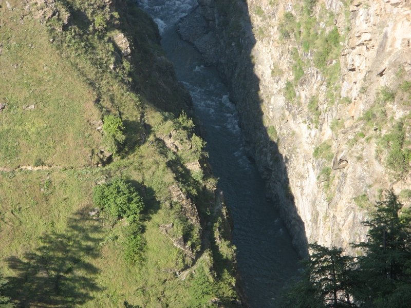 Ravi river down the drain Ravi river down the drainThere was a dry dead tree close to the temple with a small hut which gave an eerie look as the sun was setting. I took innumerable pictures of the tree, some myself, some with Gavin and me brainstorming to get a sharp, yet eerie shot. All angles were tried, high exposure shots with the camera placed on the road, me lying in drain alongside, camera tilted up on small rocks and pebbles, Gavin holding a torch; first for me to have light to see by and then focussed on the tree to get a better shot. After around 15 not so successful attempts, we gave up trying as the light dwindled and decided to get up early. At least I did, Gavin at any rate was not going to get up that early. It is worthwhile mentioning here that Jango had by now, names for both Gavin and Patrick. Patrick was 'Yogi Baba' for his morning Yoga habits and Gavin was 'Lajee Baba', (Lajee being a mispronunciation of Lazy), for obvious reasons. |
|
| ()
Thanks
|
|
15th December 2009, 13:53
| #14 |
| Newbie Join Date: Sep 2009 Location: Palampur
Posts: 20
Thanked: Once
| Day 9 The morning started with me getting up at 5 for taking an eerie shot of the tree. I managed to get some. Here is one, judge for yourself if it is sufficiently eerie. The evening before, I also figured from conversations with people around the temple that 2 tunnels are being planned in the area. Both are ambitious projects. One is to link Bada Bhangal (बड़ा भंगाल); the village I have been wanting to go to for a long time now, to Chamba and the other to link this part of Chamba through a tunnel straight to Baijnath. While these will do  wonders to the region in terms of accessibility and probably even mass tourism, the long term effect is hard to predict. On the note of development, there is this thought I had about sustainable development. Given the average human life span of 80 years, even visionary humans are not capable of thinking beyond 3-4 centuries. As lacking as the human race is in understanding the earth's geological and environmental processes, with a maximum vision of 3-4 centuries, how can anything we do be sustainable in the long term? Its more like a roll of dice than a thought out path to development. Should we even bother? Conversely, if we are so bothered, should we even develop? wonders to the region in terms of accessibility and probably even mass tourism, the long term effect is hard to predict. On the note of development, there is this thought I had about sustainable development. Given the average human life span of 80 years, even visionary humans are not capable of thinking beyond 3-4 centuries. As lacking as the human race is in understanding the earth's geological and environmental processes, with a maximum vision of 3-4 centuries, how can anything we do be sustainable in the long term? Its more like a roll of dice than a thought out path to development. Should we even bother? Conversely, if we are so bothered, should we even develop? Coming back to the subject of the trek, we steeply climbed down a path from Lake wali Mata temple to cross yet another stream through a shaky suspension bridge and then climbed back up even further to pass just below the village of Surai (सुरई), orchards laden with apples, the morning sun streaming right into the village. From Surai onwards, the trail changed completely. It was pretty clear the pass would be different too. We never seemed to be climbing steeply. It was always a net climb up through an undulating trail. At 10 in the morning, we stopped at Bela wali Mata (बेला वाली माता) temple for a tea and I took the opportunity to have another cold water bath in a waterfall. This one was difficult though. The surface was all shale stone jutting out of the surface, making it difficult to walk barefoot. Plus there was no pool of water to dip in. However, having committed myself to a bath, I was not about to go back dirty. Lying down along slope of the stream and letting the water flow around me and over me, wherever it could, was the best I could do. I had feet blued by the cold water to show for my effort. Do not try bathing with the cold water anywhere on the trail if you have any joint, muscular problems or are not used to cold water baths.  We figured at the tea break that a group of blind people from Kolkata was also scaling the Jalsu pass. It suddenly seemed to dwarf whatever I thought I had done. It takes something to cross a mountain pass with vision. Without vision, I cannot even imagine the effort and can only bow down to the enthusiasm of these individuals. Was it only me who felt that the blind are better than the ones with eyes? We figured at the tea break that a group of blind people from Kolkata was also scaling the Jalsu pass. It suddenly seemed to dwarf whatever I thought I had done. It takes something to cross a mountain pass with vision. Without vision, I cannot even imagine the effort and can only bow down to the enthusiasm of these individuals. Was it only me who felt that the blind are better than the ones with eyes?Gavin and Patrick, who had seemed indisposed a day ago because of their stomach problems seemed to have rockets up their backsides since the beginning of this day. The rocket fuel lasted till we reached the pass. Lunch was prolonged, a full one and a half hours at Channi (चन्नी) at a small makeshift shop run by an old Nepali. Along this trail, which has greener pastures and jungles as compared to the Indrahar trail, there are a lot of seasonally manned shepherd stops like Channi with Nepali migrants running temporary meal shops. The old Nepali had to cook our dal and rice meal from scratch and we took the opportunity to laze around a little. Gavin did not mind reading a book lying on his mat placed in goat droppings.  From Channi, we ascended sharply and gained around 250 metres in altitude within 35-40 minutes before again walking on a flat, winding trail, transcending many ridges up to Yada Goth, our stop for the night. The way to Yada had clear marks of a poplar plantation by the forest department along with some natural Badoh (बड़ोह) trees. Yada Goth is the base camp for Jalsu pass. Located at 2700 metres above the mean sea level, it is again a shepherd stop, has a temporary shop and a Forest Rest House.  The view from Yada was a complete contrast from anywhere on the Indrahar trail. There are sprawling, sloping grasslands, a generous sprinkling of deodars on the way, lots of dark green Rhododendron bushes. Sitting in the rest house, I wondered at the kind of people I had already met just being 9 days out of my comfort zone. Gaddis from a remote village in Chamba, settled in Dharamshala doubling up as trek guides; two westerners, one 23, planning for a career, another 28, already turned Yogi; a group of courageous blind people going up Jalsu; lots of inquisitive locals; shepherd ladies and men shepherding their herds across the pass for the winters; some armchair tourists at Lake wali Mata; local Gaddi families in Kuvarasi and Lamu. Add to that the experience of living in caves, waking up and sleeping with the sun, eating organic produce, game meat, drinking home-made alcohol, bathing in waterfalls, seeing pines at 3000 metres above sea level. And all this in 9 days!! No wonder they say travelling is the richest experience one can get. The view from Yada was a complete contrast from anywhere on the Indrahar trail. There are sprawling, sloping grasslands, a generous sprinkling of deodars on the way, lots of dark green Rhododendron bushes. Sitting in the rest house, I wondered at the kind of people I had already met just being 9 days out of my comfort zone. Gaddis from a remote village in Chamba, settled in Dharamshala doubling up as trek guides; two westerners, one 23, planning for a career, another 28, already turned Yogi; a group of courageous blind people going up Jalsu; lots of inquisitive locals; shepherd ladies and men shepherding their herds across the pass for the winters; some armchair tourists at Lake wali Mata; local Gaddi families in Kuvarasi and Lamu. Add to that the experience of living in caves, waking up and sleeping with the sun, eating organic produce, game meat, drinking home-made alcohol, bathing in waterfalls, seeing pines at 3000 metres above sea level. And all this in 9 days!! No wonder they say travelling is the richest experience one can get. |
|
| ()
Thanks
|
|
15th December 2009, 14:13
| #15 |
| Senior - BHPian | Excellent narration. Let it come. I had missed this pass, heard a few good things about it and then totally forgot about it. Now that you ahve raked it up, please post some detail pictures of the route ex holi. It will be now on the itinerary and will be clubbed hopefully with the next trek into Bharmour. |
|
| ()
Thanks
|
|