Team-BHP
(
https://www.team-bhp.com/forum/)
Good news for bikers - one lane of the Suntikoppa - Madikeri stretch is completed and closed to larger vehicles :) I did my usual 5:15 ride to Bhagamandala in 4:45! I guess the road will open in 2-3 weeks at most to all traffic.
The Suntikoppa - Madikeri stretch is almost completely done, except a couple of short patches. Squeezed in past the checkpost at the diversion since we got there really early this morning on our way back to Bangalore, and it saved a cool 20 minutes. The guy at the checkpost said its officially opening on the 3rd of May.
Has anybody travelled on this stretch recently? Is the road work completed and Suntikoppa-Madikeri stretch open? I am planning to drive to Coorg(Madikeri) early next week.
Quote:
Originally Posted by Abhinit
(Post 1884548)
Has anybody travelled on this stretch recently? Is the road work completed and Suntikoppa-Madikeri stretch open? I am planning to drive to Coorg(Madikeri) early next week.
|
Yes, its open, and nice and smooth. There's a couple of hundred metres where there's still some work, but its done, including decent shoulder space. Watch for buses on the curves tho - they're only learning what their optimal speeds on those are :)
Not just this, the interior roads in Coorg are also vastly improved or at least patched. Of course, the furious monsoon pounding out there might change that, but for now - things are way better.
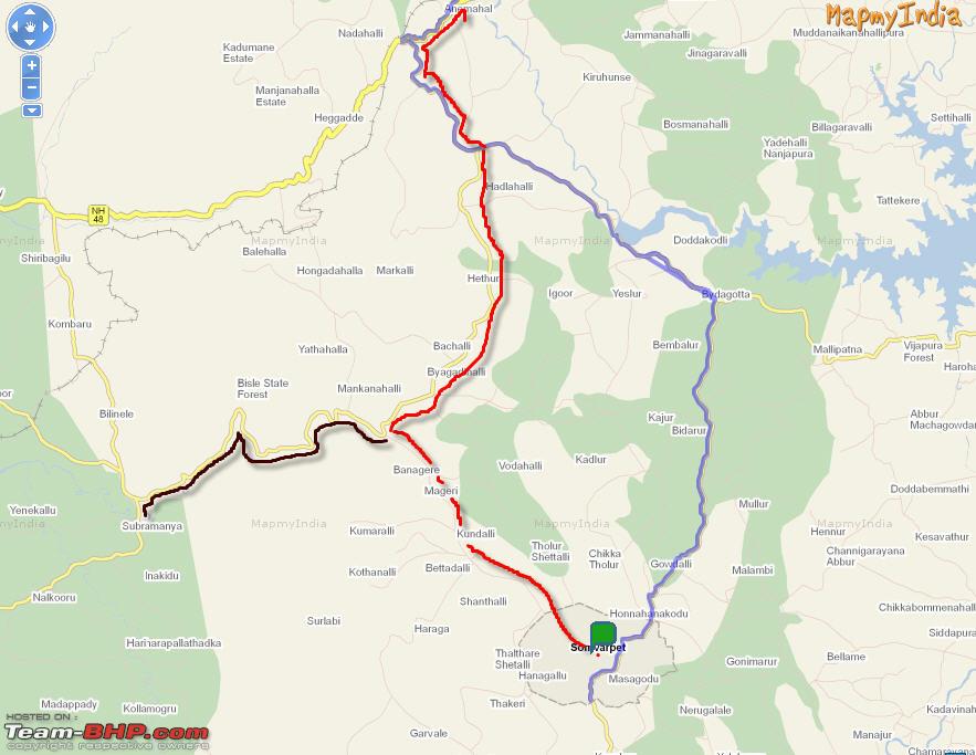
Is there a direct route between Somwarpet to Subramanya?
The image show an almost complete route from Google Maps, is it complete in real? Is that same as Bisle Ghat?
I want to avoid the long circuit through Sakleshpur.
Quote:
Originally Posted by Samurai
(Post 2018485)
Is there a direct route between Somwarpet to Subramanya?
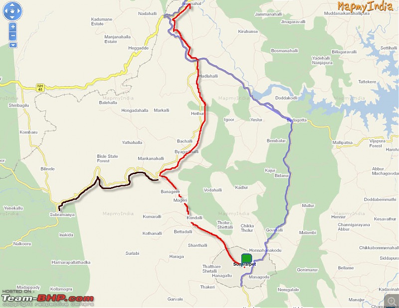
The image show an almost complete route from Google Maps, is it complete in real? I want to avoid the long circuit through Sakleshpur. Attachment 402857
|
The route which is shown on the map is open only until Heggademane village at the base of Kumaraparvatha mountain. You can continue to Subramanya from here on foot and this is a popular trekking trail. Subramanya should be approx 10 kms from this place.
There was a proposal to build a road from Heggademane to Kukke Subramanya, but that would pass through the pristine forests of Pushpagiri wildlife sanctuary (which is on the tentative list of the UNESCO World Heritage site) and hence, it was not given permission.
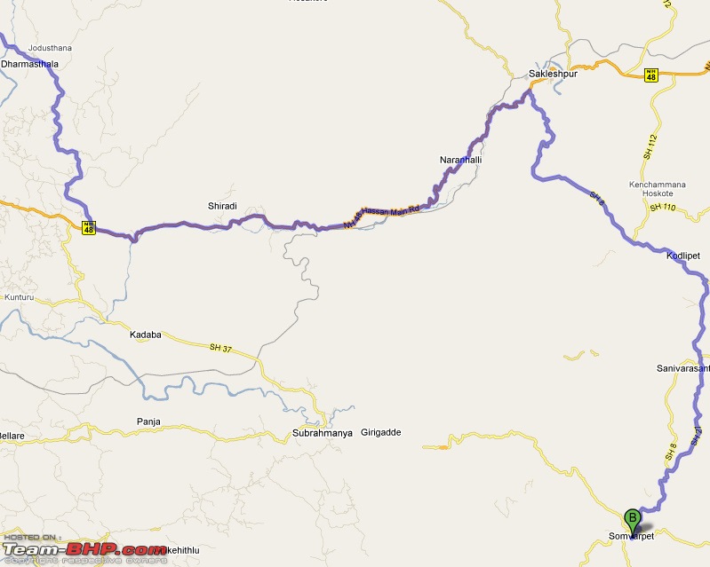
There is another route to reach Sakleshpur from Somwarpet. Take the Pushpagiri route (SH85 in G Maps) from Somwarpet. You will come across a place called Kundalli where there is a fork in the road. Left takes you to Mallalli and right takes you to Sakleshpur via Bisle road.
If you take the right side, you will pass through Mageri village and after that, this road will join the Bisle ghat road after Vanagoor. Taking left here will go to Bisle ghat-Kukke and taking right goes to Sakleshpur via Vanagoor Koodu raste-Hethur-Donigal
The road is good all the way from Somwarpet till it joins the Bisle ghat road. Bisle road should be bad (I think you know:)).
This route is shown on the Map my India portal (see screenshot). The red route is to Sakleshpur and the black route is to Kukke Subramanya.
For some more info on this region, you can check out this travelogue
http://www.team-bhp.com/forum/travel...lli-falls.html
Thanks addyhemmige, that was very helpful.
There were talks of extending the Madikeri - Gallibedu road till Kukke Subrahmanya. Any updates on this one?
Hi Guys,
Did a search on Bangalore-Coorg route and found this thread to be the most active.
This weekend (17-19 Dec) I am planning to Cruze down to Coorg (to Misty Woods, to be precise- probably that is at Virajpet- Google showed it there).
Can you please provide a recent update on the routes? I am planning to take the same route both ways:
Bangalore-- Mysore--Hunsur--Gonikoppa--Virajpet-- Madikeri
Already visited Kushalnagar (Monastery) & Nisargadhama- so those are out of my itinerary.
TIA,
~Animesh
I visited Coorg a month back. Srirangapatnam -> Ranganthitu -> Hunsur is bad with lots of pot holes. Not recommended for night!
If possible take alternate route to skip this even though it takes additional 30kms. Its worth it!
Quote:
Originally Posted by devrajman
(Post 2173894)
I visited Coorg a month back. Srirangapatnam -> Ranganthitu -> Hunsur is bad with lots of pot holes. Not recommended for night!
If possible take alternate route to skip this even though it takes additional 30kms. Its worth it!
|
Thanks Devang.
So, I will take the longer route of (Mysore) Ring Road to reach Hunsur Road.
But what about the remaining part of it?- Hunsur onwards. I saw several posts here on varying conditions in different parts of the season!
Rest is good. You can do 80-100 for most of the times like Mysore Road, Hunsur Road.
Beware of some speed breakers
However inside and around Kushalnagar & Medikeri roads are really bad!
I am looking at making a trip to Coorg (Madikeri) during the new year weekend. It will be in my Swift. From Chennai, where near Bangalore do I have to take a turn to go to the Mysore road? What is the suggested route from Mysore to Madikeri? Any pointers would be of great help. Thanks
Quote:
Originally Posted by arvind71181
(Post 2176888)
I am looking at making a trip to Coorg (Madikeri) during the new year weekend. It will be in my Swift. From Chennai, where near Bangalore do I have to take a turn to go to the Mysore road? What is the suggested route from Mysore to Madikeri? Any pointers would be of great help. Thanks
|
Once you get near to Electronic City, you will see toll booths to enter elevated road. DONT go thru the toll booth. Just next to the toll road, a road goes below the elevated road, take that. You will see all the city (BMTC) buses taking this road, just follow them. After 1-2 kms, you will see a small sign board pointing towards Mysore/NICE road. Take the service road/ramp on the left, which leads you to NICE road, and invites you with the toll booths.
Once you get on NICE road, you have to get down from this road at Bannerghatta road and again enter back on NICE road. The bridge connecting either side of NICE road is missing here. But dont worry, its a very minor deviation.
At toll booth at Bannerghatta Road, pay the toll for Mysore road exit. From here till Mysore road exit, its quite a distance (dont remember) and the exit to Mysore road comes on your left. And you are already on Mysore road!!!! You saved your time and money on fuel already! :-)
From here on: Bidadi->Ramanagar->Channapattana->Maddur->Mandya->Srirangapattana. It is one single road where you will visit all these towns. After Srirangapattana, ask for Ranganatittu exit which comes on your right side, just after you cross bridge on cauvery river. If you cross a railway gate in less than a kilometer, then you are on right track:-) This road is little rough for about 10-15 kms but you wont scrape anywhere except at one place, where there is one or two big potholes, just be careful there.
If you want to avoid the above route, go straight from Srirangapattana, just when you enter Mysore, you will hit ring road (first signal/lights of Mysore). Take right there and keep on going on this road till you see Hunsur/Madikeri road intersection, where you have to take right. I heard ring road widening is in progress, so it is kind of messy there.
So, this road (the road where you take right turn after Srirangapattana) ends at Mysore-Hunsur/Madikeri road which is four laned road. Take right on that road, from here: Mysore->Hunsur->Kushalnagar->Shuntikoppa->Madikeri. Good roads all along, except 2-3 kms just before Madikeri.
Hope this helps! :-)
Selective,
You mentioned that the Kushalnagar-Madikeri route is good. What about the other one: Hunsur--Gonikoppa--Virajpet-- Madikeri? Is that route fine?
I need to go to Kakkabe- I am starting tomorrow morning.
Any quick update would be appreciated.
Thanks....
| All times are GMT +5.5. The time now is 21:40. | |