Team-BHP
(
https://www.team-bhp.com/forum/)
Hi guys,
Am planning to visit Jog falls on my visit to Mangalore. Plan to leave on 15th Aug and return on 19/20thAug.
The tentative route is
1) Mumbai-Hubli. Overnight in Hubli.
2) Hubli-Jog falls-Mangalore (after spending a couple of hrs at Jog)
Stay in Mangalore (actually a place called Vitla which is my ancestral town and have a home to stay, near Mangalore) for a couple of days.
Return to Mumbai via Goa with a stopover somewhere on the way.
Will be travelling with my wife in an Indica V2DLS. Only I will drive. Will stop often for photo-ops too.
Any inputs/suggestions on road conditions and stayovers welcome.
Regards,
Deepak.
From last 1 week there is heavy rain fall these areas. Daily avg is like 30cm rain. Its like 24/7 rain.
Today water of 1.5 lac csq is released from Linganmakki Damm so Jog is in full glory infact this is first time in last 10 years so much of water released. Many people called me and told low lying areas are flooded in Honnavar, Kumta, Ankola, Karwar.
Road between Shimoga -> Sagar closed because of water level increased too much on road. Same case with Shimoga -> Thirtahalli road, however you need not travel by these roads.
It happened last year too but this year its raining still more.
However on the day you visit If it rains heavily and if cloud is too much you might have to wait for hours together to see Jog falls because of mist/fog in that area.
This weekend or next week is right time to visit Jog because its in full glory.
From Hubli you need to take one of this route:
Hubli -> Mundgod -> Sirsi -> Siddapur -> Jog Falls. Distance is around 175km.
Its like 0 -> 50 -> 100 -> 140 -> 175 km.
I plan to visit my native in 1 week time just waiting for rain to come down.
Because many roads are closed because of heavy rains this week.
Next week I can give you latest updates about these areas.
Regards,
Ravi.
Check
here,news about the floods in Mangalore.
@Ravi... thank you so much for all the info... shall await your latest report after you visit your native place. Would be glad if I could get some info on the Hubli-Jog Falls-Mangalore roads.
@rjstyles.. thanks mate...hope the floods subside by Independence Day!
Magic: As Ravi mentioned its raining very heavy but you could get the best if the rain gods are willing:)
If possible try to take this route from jog to M,lore
"Jog - Agumbe - Kollur - Nh17 "
but it would be raining very heavily in this region, make sure you have fog lamps fitted on your car:)
Last summer i did this route and was amazed, it would be much better now.
Would be great if you can take the karkala route to M,lore instead of Nh17, though it would take more time but definately is fun to drive.
have fun
@lohit ... thanks very much for your inputs...will keep all options open...dont have fog lamps fitted, should get that done..thanks
@black12rr... thank you for the news link... hope alls ok a day after independence day and can make it...god willing!
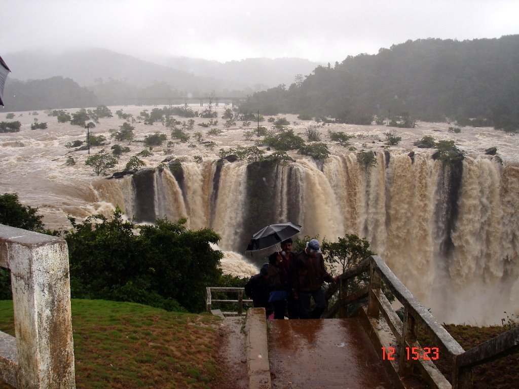
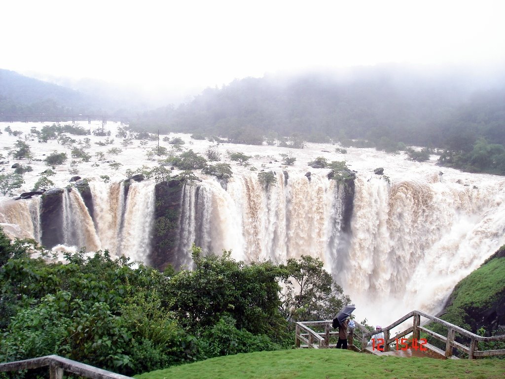
I just got these pics as a forward. Looks like the same pics were doing rounds last year too. Not shot this year for sure.
Jog hasnt reached this point as yet. The dam gates have opened up only yesterday, so maybe by tomorrow should be full.
Hi Deepak,
Since its rained heavily roads are in bad state hovewer most of the stretches between
Hubli -> Sirsi -> Siddapur -> Jog are newly laid roads (around year back) so you can take this route.
From Jog Falls take either Jog Falls -> Honnavar -> Bhatkal -> Baindur -> Kundapur -> Udupi -> Mangalore OR Jog Falls -> Sagar -> Shimoga -> Tirtahalli -> Agumbe -> Karkala -> Mangalore route.
I suggest second one reason is its very nice drive although might be bit long stretch and road should be better than first route because NH 17 is in bad state.
Please don't do 2nd route in late evenings and nights Risk naxalite. Even Jog forest area is bit risky too so need to be careful I remember my driver using less horns in these forest area (shimoga/sagar/jog ghats) just because some dacoits might attack ;) even in day time!
Water is released from Damm and Jog is just 10km from Damm so within minutes of water release Falls is like flooded area!
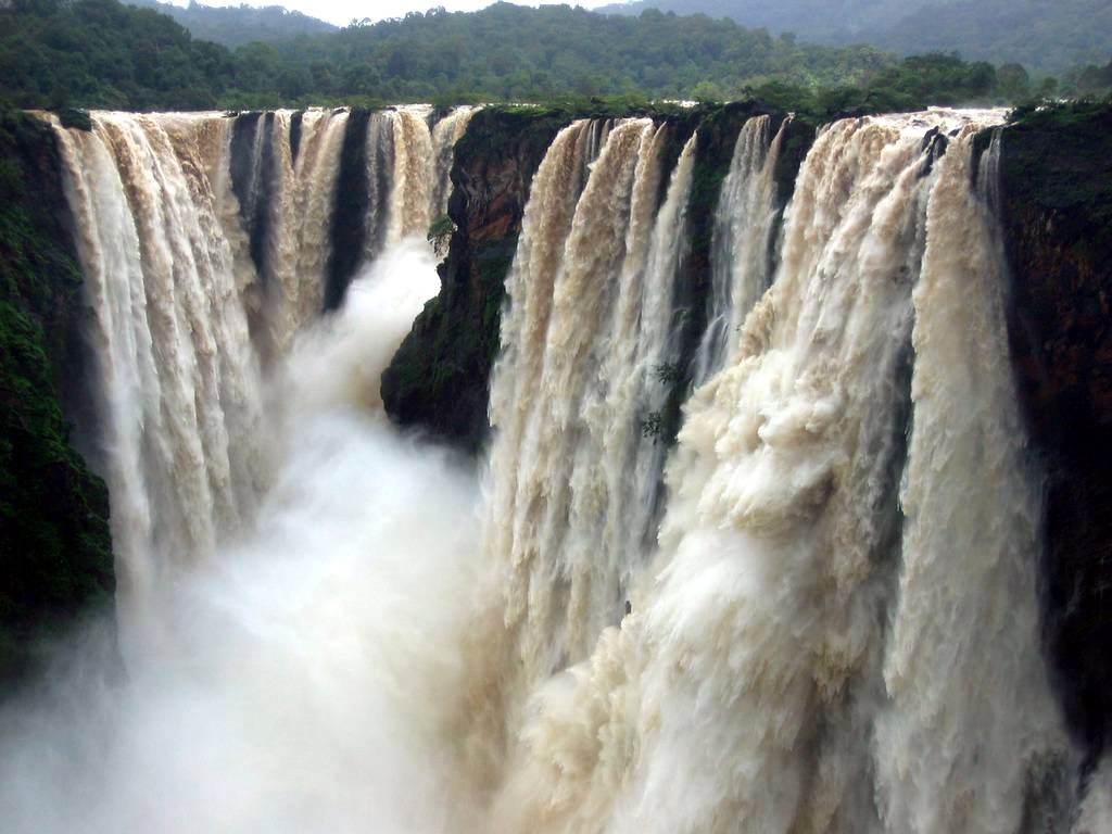
I heard its like a Nayagara falls same as in above pictures.
I heard rain has come down now so this week end is very good time to visit.
I might head to native place in couple of days.
Regards,
Ravi.
Quote:
Originally Posted by ravibhat
(Post 525691)
I heard its like a Nayagara falls same as in above pictures.
|
It does look like Niagara falls, that was my first reaction after seeing the pictures.
Quote:
Originally Posted by dadu
(Post 525733)
It does look like Niagara falls, that was my first reaction after seeing the pictures.
|
Difference is Niagara is 167ft. While Jog is 829ft :Cheering:
Seeing the pic in post #8 is really scary, its looking like an out of control flood situation:Shockked:
| All times are GMT +5.5. The time now is 06:53. | |