Team-BHP
(
https://www.team-bhp.com/forum/)
MapMyIndia has introduced a new feature called Junction Views for navigation in its
free Mappl app.
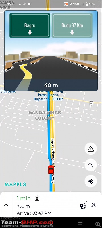
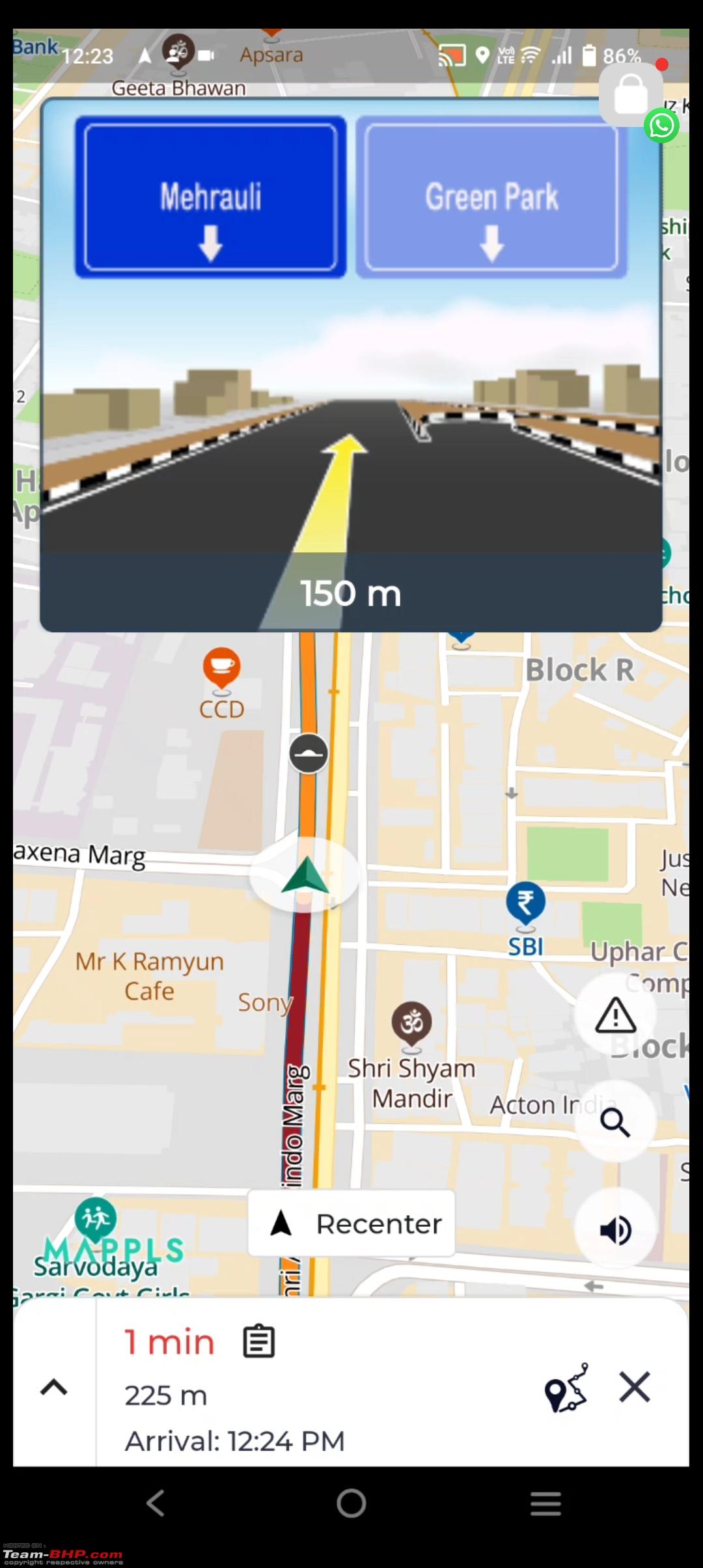
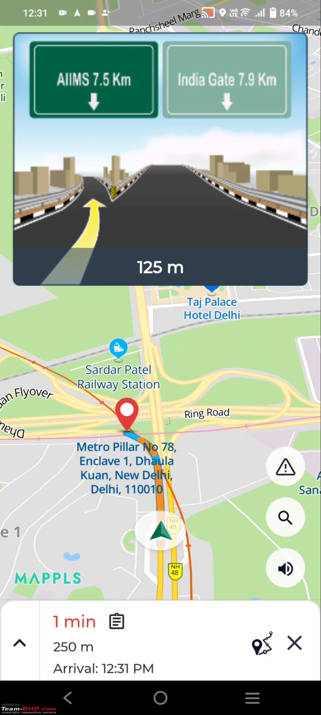
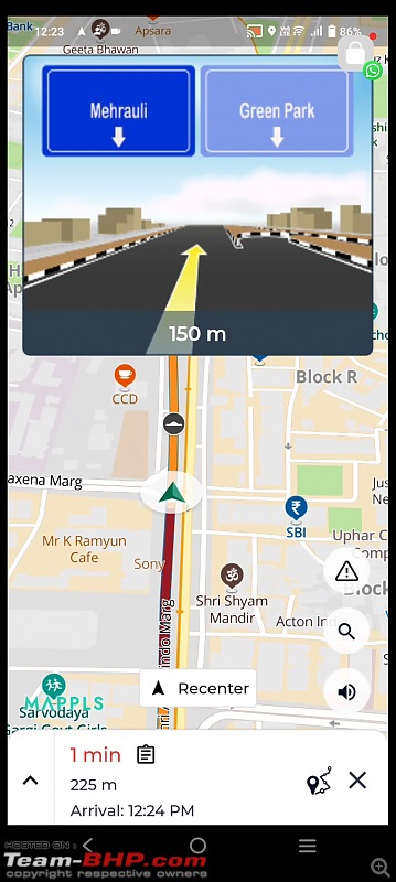
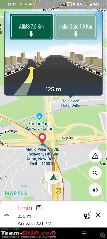
The new Junction Views feature can be handy when navigating through a complicated interchange, or while approaching a flyover ramp or a fork in the road. The app displays a 3D representation of the junction with marked lanes. The highlighted mark shows the exit or entry of the flyover in a photo-realistic format. It also shows a preview of the next junction, if available.

According to the company, the Junction Views feature is designed to help people navigate while approaching flyovers or junctions and is unique to its indigenous navigation app. The company also claims that the new feature would help prevent accidents like car pile-ups during foggy conditions.
MapMyIndia’s Junction View feature is available across multiple cities and highways, including Delhi, Noida, Gurgaon, Kolkata, Mumbai, Pune, Hyderabad, Bangalore, Chennai, Ludhiana and Lucknow.
 https://www.youtube.com/watch?v=029ZVZYSgqE Link to Team-BHP News
Quote:
Originally Posted by TusharK
(Post 5462577)
The new Junction Views feature can be handy when navigating through a complicated interchange, or while approaching a flyover ramp or a fork in the road. The app displays a 3D representation of the junction with marked lanes. The highlighted mark shows the exit or entry of the flyover in a photo-realistic format. It also shows a preview of the next junction, if available.
|
This is a welcome news, and a great feature to have. I use Google Maps extensively for my travels and road trips. One thing that can get confusing while using Google Maps, especially in new cities, is navigating to/on flyovers. I have got confused numerous times in unknown cities when Google maps gave me vague instructions while approaching flyovers. Great to see MapMyIndia addressing this key question and adding this very useful feature in their app.
I have also used MapMyIndia and their apps in the past. While their navigation was always good, their map database is also quite extensive now, and they have added live traffic updates too. However, the search engine (for searching for places) is still quite weak, and this is where Google Maps wins big time for me. If I know a half-name of a restaurant (just as an example), I can still easily find that location in Google Maps. On the contrary, last time I used MapMyIndia maps, I had to enter the exact destination name and location and that was often a pain.
Anyways, with so many recent improvements in MapMyIndia, it has come a long way. I will use it again now just to check out the latest version and see the improvements.
Quote:
Originally Posted by TusharK
(Post 5462577)
MapMyIndia has introduced a new feature called Junction Views for navigation in its free Mappl app.
|
Isn't this already implemented?
This feature is already available in the in-built mapmyindia maps of MG ZS EV. It is quite useful when approaching a unknown junction.
This is also available in the built in maps in XUV700 along with the speed camera warnings.
This feature is available with built in navigation on Hyundai Alcazar. It's really quite user friendly and gives clear suggestion on which lane to choose while on a junction. However, the map database lags behind. For example, the diversions for metro constructions, dismantled 3 months ago, still shows on the map, even while app has recently been updated. Searching a POI and business availability is still miles behind GM. Searching it on mobile and sending it to car AVN system makes it a tad bit easier though.
Looking forward to MMY keeping proper update mechanism in place making it fully dependable.
Quote:
Originally Posted by Dr.AD
(Post 5462603)
One thing that can get confusing while using Google Maps, especially in new cities, is navigating to/on flyovers. I have got confused numerous times in unknown cities when Google maps gave me vague instructions while approaching flyovers. Great to see MapMyIndia addressing this key question and adding this very useful feature in their app.
|
+1
I remember some years ago, I drove to Bangalore for the first time.
The Google map instructions were kind of vague and I somehow missed the fork which was supposed to lead me to the NICE road.
I realised my error (just after I took the wrong road) and had to travel quite some distance to find a U turn.
One of the things which I find lacking clarity in Google maps is the style of instruction.
e.g. "Take the second exit"
Every time I hear this, I need to take my eyes off traffic and check what 2nd exit actually means. Most of the times, it means go straight at the roundabout!
Their DAU is so less, no one will see or benefit from it. I don't know anyone who actually their consumer app. Their APIs are used, but then I don't know of apps that would benefit from this.
Has anyone tried using this Mappls app on Android Auto? I couldn't find it in my car while driving. It makes little sense to use it if it's not supported on Android Auto.
The junction view feature is available on my 2019 Ford Figo built in satnav with no updates till date. (This reminds me, I should follow that YouTube tutorial to update the maps).
Anyways, tried using the Mappls app today for navigation.
Started off well enough, giving the correct directions, pre warning regarding speed breakers. The only annoying item was that it was warning me about speed breakers "four hundred ninety three meters ahead" instead of a full 500. In this unnecessary accuracy, it missed telling me about a right turn that I had to make about 20 minutes after I started navigation.
It all went downhill from then on. The voice navigation stopped working altogether. I tried restarting the navigation, restarting the app but voice directions refused to work. I promptly switched over to Google Maps for the rest of my 14 hour trip that worked without a hitch the entire while.
They have something good but they need to get some of the basics right. I don't need to know if a speed breaker is "four hundred and seventy three meters away". Just say 500, it's alright, I can manage. And voice based turn by turn directions cannot stop working in the middle of a drive. Those have to work too for the app to be any use while driving.
Street view and 3D buildings are nice to have features but the core needs to work well first.
This is a very welcome feature. However MapMyIndia is not the first player to do this.
If i remember correctly, Sygic app used to show the junction feature (atleast near flyover entry). The maps were later available for free also where initially it was paid feature. This was way back in 2016 maybe.
Quote:
Originally Posted by speedmiester
(Post 5462649)
This feature is already available in the in-built mapmyindia maps of MG ZS EV.
|
Quote:
Originally Posted by A M
(Post 5462708)
This is also available in the built in maps in XUV700 along with the speed camera warnings.
|
Quote:
Originally Posted by Haldian
(Post 5462712)
This feature is available with built in navigation on Hyundai Alcazar.
|
It was there for long time in all ICE which use MapMyIndia offline maps. But not in Mappl app.
Quote:
Originally Posted by anuragsingh
(Post 5463007)
Has anyone tried using this Mappls app on Android Auto?
|
It is supposed to be supported, although I have never used it as Google Maps has way nicer integration. If you see the pictures, I think third or forth is the one with Android Auto.
https://play.google.com/store/apps/d...maps&jsmode=du
I have seen this feature in my inbuilt navigation system for Hyundai Alcazar. I guess they are using MayMyIndia as backend system. It is very useful. As rightly pointed out in the forum, database is definitely a bit outdated as compared to Google Maps.
Does MayMyIndia provide speed limits as well ? It seems Alcazar scans the speed limits from road side warnings and display it on nav system.
MapMyIndia, though has very strong feature set, it needs continuous updates and a sizeable active userbase - currently difficult owing to Gmaps.
GMaps is direct, simple and enough informative for 99% of usecases.
Coming to the junction view, though Gmaps doesnt show a clear view of junction like MapMyIndia, it does have a mini-junction guidance views - it shows the available lanes, and highlights the lanes we need to take.
Its little easy to miss observing this feature, as its not too clear to see while driving.
Check the image below (taken from google, as I couldn't capture one while driving)
Quote:
Originally Posted by maximus_fiat
(Post 5464001)
It seems Alcazar scans the speed limits from road side warnings and display it on nav system.
|
This is also provided by MapMYIndia. AFAIK Alcazar does not scan road signs as it does not have any ADAS related functionalities.
Does the Mappls app also show and alert about speed camera traps? WhenI went once on Yamuna Expressway, it showed and announced the speed cams. But it does not do that any more, in Delhi.
| All times are GMT +5.5. The time now is 23:03. | |