| |||||||

| Search Forums |
| Advanced Search |
| Go to Page... |
 |
| Search this Thread |  267,818 views |
 31st August 2011, 09:34
| #46 | |
| Senior - BHPian Join Date: Oct 2006 Location: MH42
Posts: 2,006
Thanked: 334 Times
| Re: When I Went Walking To Tibet - Kailash Mansarovar Yatra-2011 Quote:
Yesterday night, i saw a program on Chinese aggressive mode on Indo-China border, a retd gen mentioned that there are simply no roads upto the border for supplies and back up for our men on border. Your figs about trekking part on Indian side vindicate the General's statement. God save our country. | |

|  ()
Thanks ()
Thanks
 |

| |
|
31st August 2011, 12:11
| #47 | ||
| Senior - BHPian Join Date: Jul 2008 Location: Jaipur
Posts: 1,194
Thanked: 1,247 Times
| Day8: Gala To Budhi (21kms) Quote:
As we go North from Dharchula, after Budhi is the first time where your passports/ travel documents will be examined. All you need is permits from the DC at Dharchula to go beyond this point (just like in leh). Nabhidhang is the last point ( I think) where Indians can go to. After that travel is restricted. So yes you can go till nabhidhang after permits. But its only a trek route Quote:
 . But yeah its true that the other side is much better prepared logistically!!! . But yeah its true that the other side is much better prepared logistically!!!CONTD DAY8: GALA TO BUDHI (21KMS) Gala: 2322 mtrs Budhi: 2686mtrs Distance: 21 kms Time taken: 11 hrs Today was supposed to be one of the most exciting and adventurous days of the entire journey. The day as usual started early. The initial 2 kms of the trek was pretty plain but then came the most arduous part. We had to descend down 4444 steps (as told by the locals) carved out of the mountain, to reach Kali river. The steps are carved out of the mountain to make it a bit comfortable but still its not easy coming down a steep descend, it was really hard on my knees. It was actually so steep that even those using pony s had to do it on foot. After a steep descend of about 3 kms we were finally on more or less level course walking along river Kali. The force of river River Kali has to be seen to be believed. I mean the force and the noise was so much that I could not even hear the person standing next to me talk. Also River Kali forms the natural border between India and Nepal on its western front. Walking on level ground and enjoying River Kali flowing with full force was a beautifull sight. Soon came Lakhanpur where we had our breakfast. After Lakahanpur we had already been told to keep our raincoats handy as we would be passing under waterfalls from here . Then came the most exciting 3 hours. The route from here got narrower and narrower. At some places it was only as wide as 2 feet. At one side was the mountain and on the other side, just beneath was river Kali waiting to swallow anyone who fell. What added to the adventure were the water falling right on the track. Not just did the water make the track slippery but it also made your shoes your clothes and everything else wet. A very good quality raincoat is a must here. Also adding to the above excitement was the crossing of batch-6 yatris, returning from their trip, right at this point. Humans are ok, they understand, they can wait till u have enough place to pass each other. But what about the mules, they just steam ahead, and you have to be the one to stop and make way for them. There was an incident, in some other batch, that a pony fell down into River Kali and was never to be found again. Luckily there was no yatri on him. In our earlier briefings we had been well prepared for this route and we realized that the instructions came in pretty handy here. The instructions were. 1. Walk in a single file, avoid overtaking. 2. Avoid photography as you might fall off trying to get the perfect angle. 3. Never lean on the railing as the railings were old week and corroded. 4. If an animal has to be given way then its imperative that you stand on the mountain side and let the animal pass on the river side. 5. Walk slowly as the rocks are slippery. The excitement slowly finished and we were filled with grief as we reached malpa. Malpa is the site of the tragic landslide of 1998 where around 400 people including yatris lost their life. Original town is still covered under rocks. In earlier years Malpa would have been our halt for the night but after the landslide incident it was decided that yatris went ahead till Budhi. So Now Malpa was just a lunch point. From Malpa the curving trail along Kali lead us to Lamari where our ITBP men were waiting for us with a smile to serve us hot tea and snacks. The route was not as treacherous as before but it was still exciting. The force of kali grew stronger as we moved ahead, waterfalls though not falling on our head but still marred the complete route. The path was not wet but was still uneven. The last stretch of the route was across a quaint bridge which leads to the Budhi camp. Budhi appeared pretty close from here but on mountains the distances can be deceptive, it still took us a while to reach Budhi. I was one of the last ones to reach Budhi camp today. Infact the route was so scenic and so mesmarizing, I thought it was pointless to rush and miss the bounties of the nature, I had the most amazing time today. Although it took me a little more than 11 hours by foot but every minute spent on this route was amazing PICS FROM DAY 8 Google map view of the route from Gala to Budhi 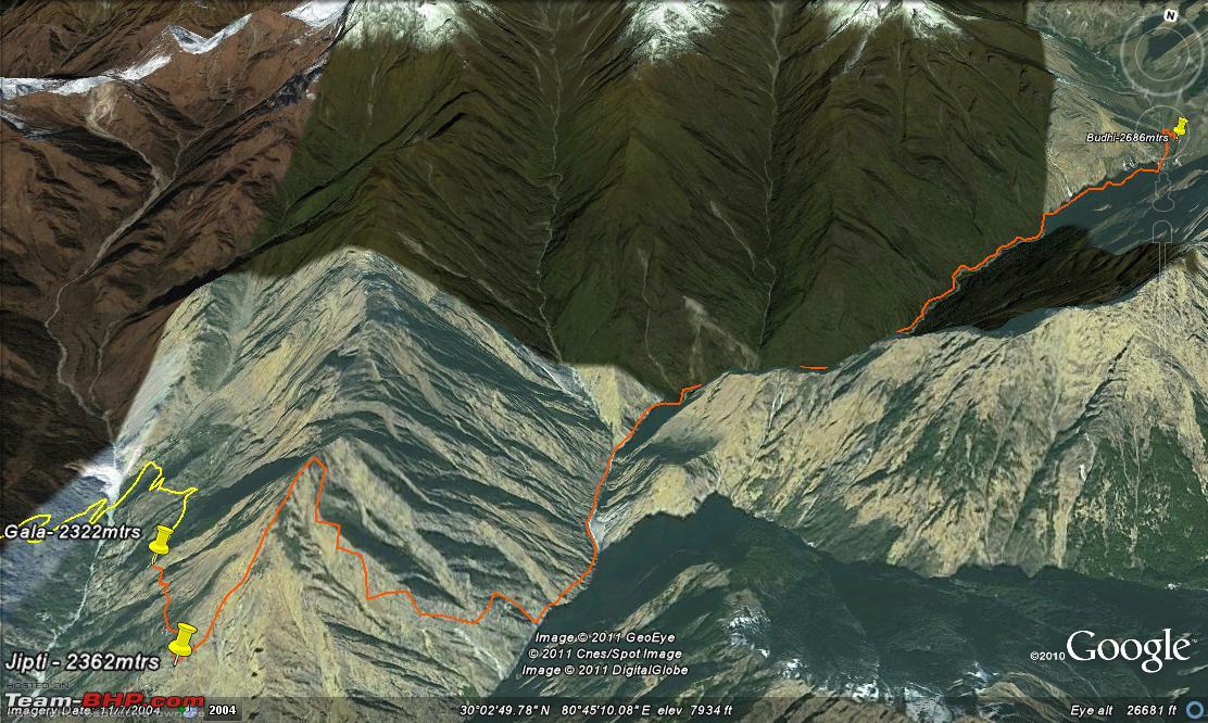 Approximate elevation of the route 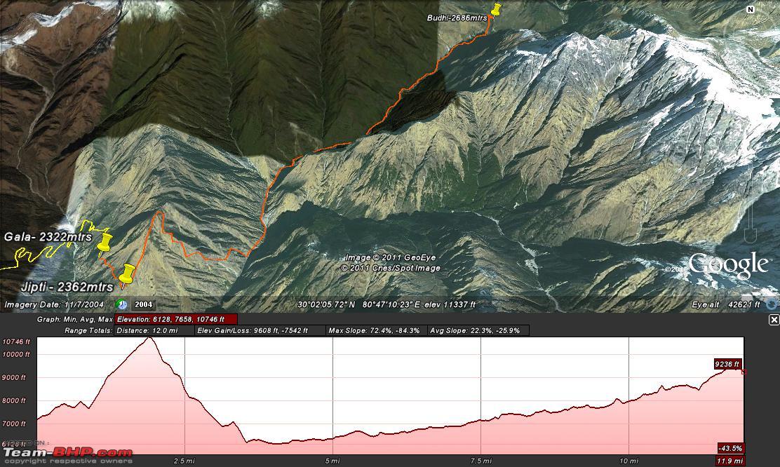 Yatris crossing the post of Jipti 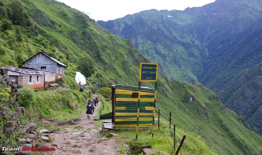 Wild flowers along the route 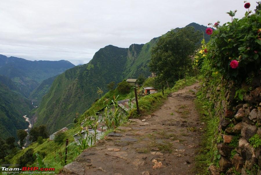 The route was pretty leveled in the beginning  A small temple just before the descend  Mountain highway and the milometers 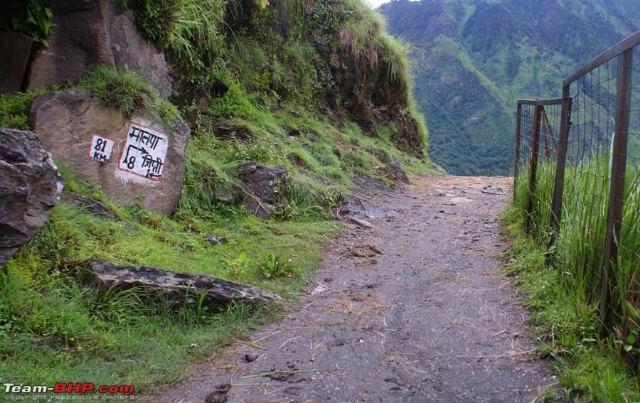 Then came the 4444 steps. Notice the 3 kms long descend till River Kali 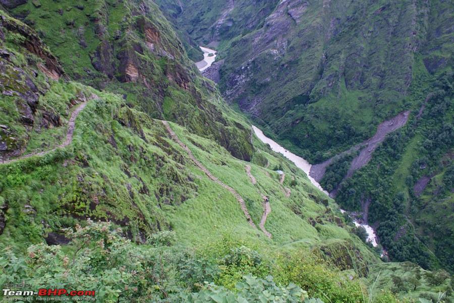 River Kali forming the natural border between India and Nepal 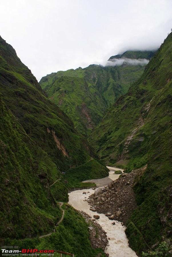 Uttrakhand Police Jawan. he was the "tail" 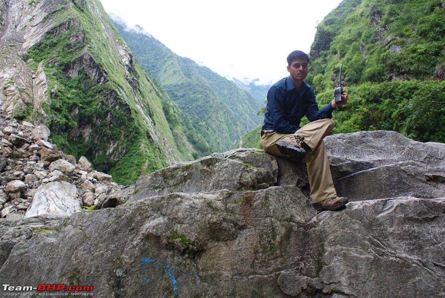 Breakfast at Lakhanpur  A porter carrying load on his head on Nepal side  Breathtaking views all along river Kali  Crossing Yatris from batch 6 on their return. In the blue cap on the left (with a camera in his hand) is Arvind, a friend with whom I have only interacted in forums but never met till this day 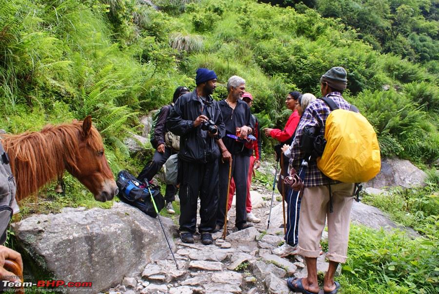 Our route along the river 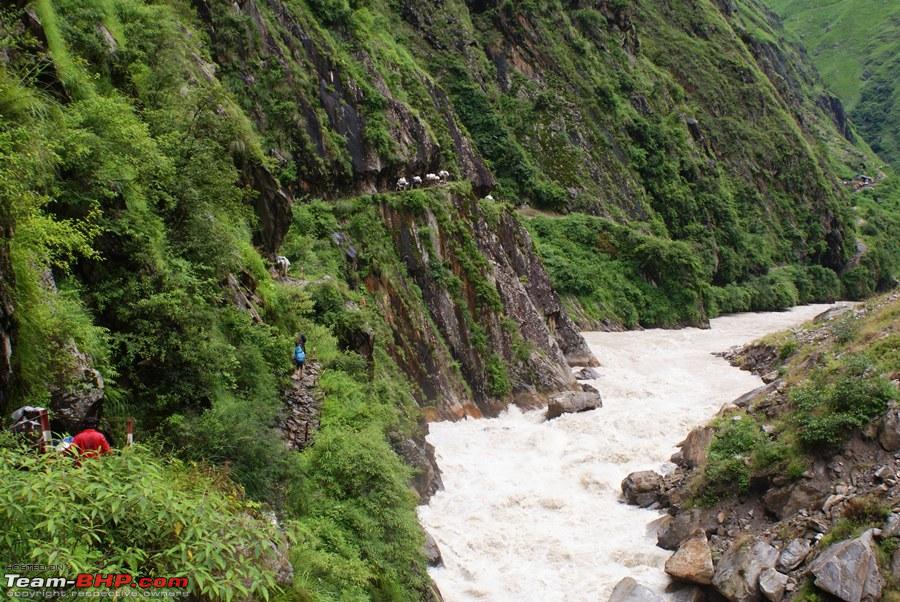 It was slippery and it was rocky, but it was fun  Route made by carving the mountain 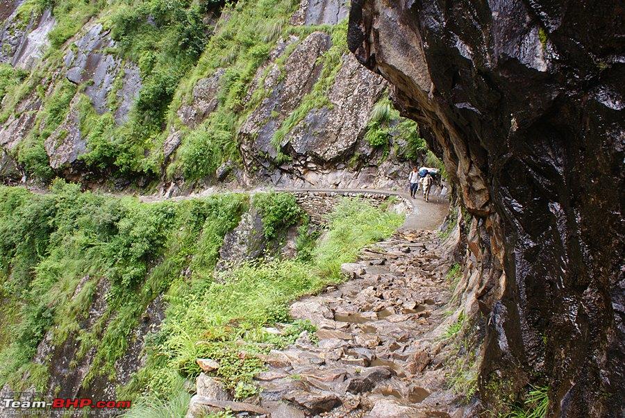 Mighty Kali flowing with full force  Trust me its not east walking for 21 kms on a stretch like this 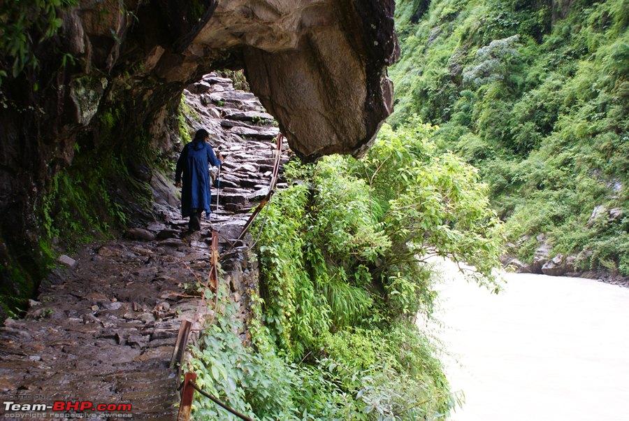 "Mule train" ahead, carrying our luggage  Beautiful streams flowing all along and all over the route 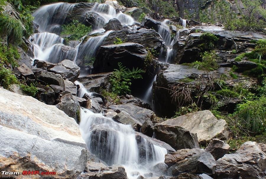 The local government has done a good job by making bridges where required  A stream joining Kali, notice the difference in colour 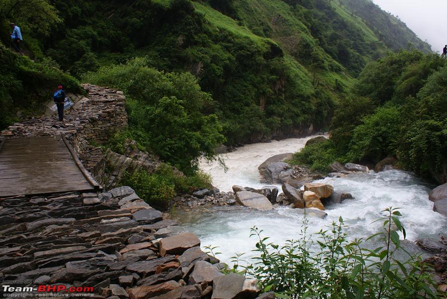 Then came the big waterfalls, a good raincoat is a must here 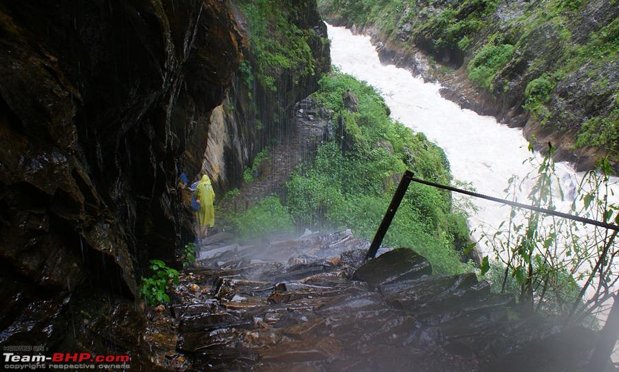 You would not want to loose concentration and slip from here 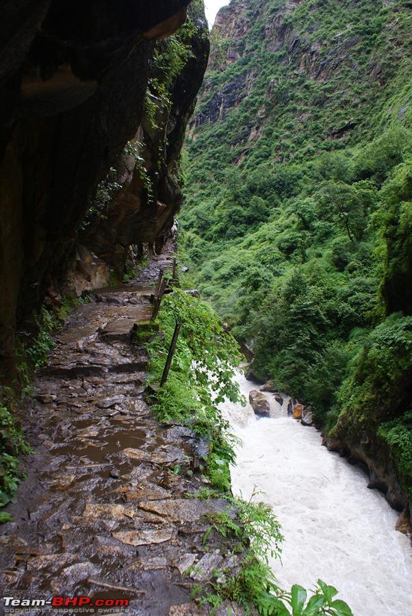 More waterfalls 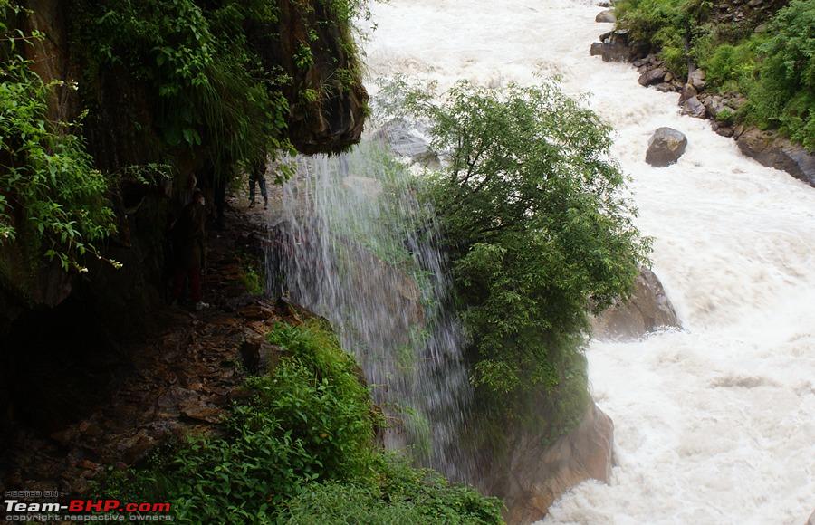 The town of Malpa where we had Lunch 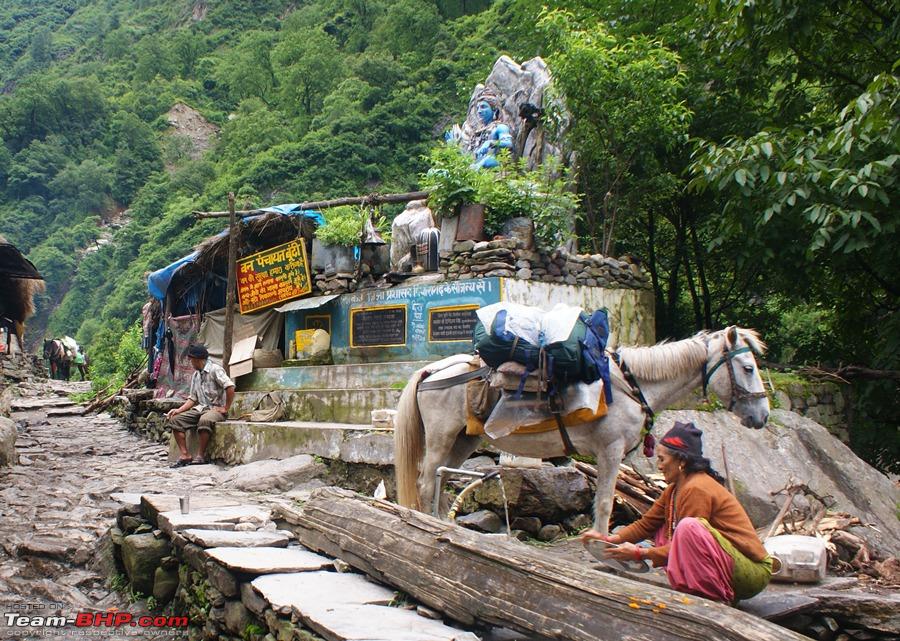 Still some distance to go before our final destination  Pics from Day8 Continued in the next post:- | ||
|
| (8)
Thanks
|
| The following 8 BHPians Thank deky for this useful post: | ampere, dailydriver, flyingkolors, Jakku, Nempuguru, saket77, wanderernomad, yosbert |
|
31st August 2011, 12:28
| #48 |
| Senior - BHPian Join Date: Jul 2008 Location: Jaipur
Posts: 1,194
Thanked: 1,247 Times
| Day8: Gala To Budhi (21kms) Day8 pics continue from the previous post..... Route got a little less slippery after Malpa  waterfalls big and small all along the route 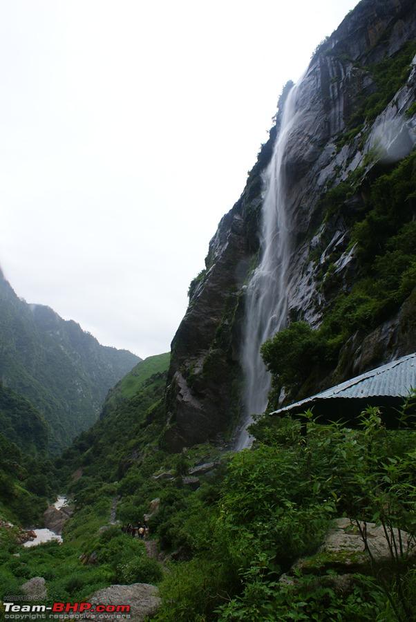 Lamari where refreshments were served  Its a tough life but they still smile  I cant get enough of these waterfalls  Yatri enjoying The Kali flow  A landslide where the path just disappeared 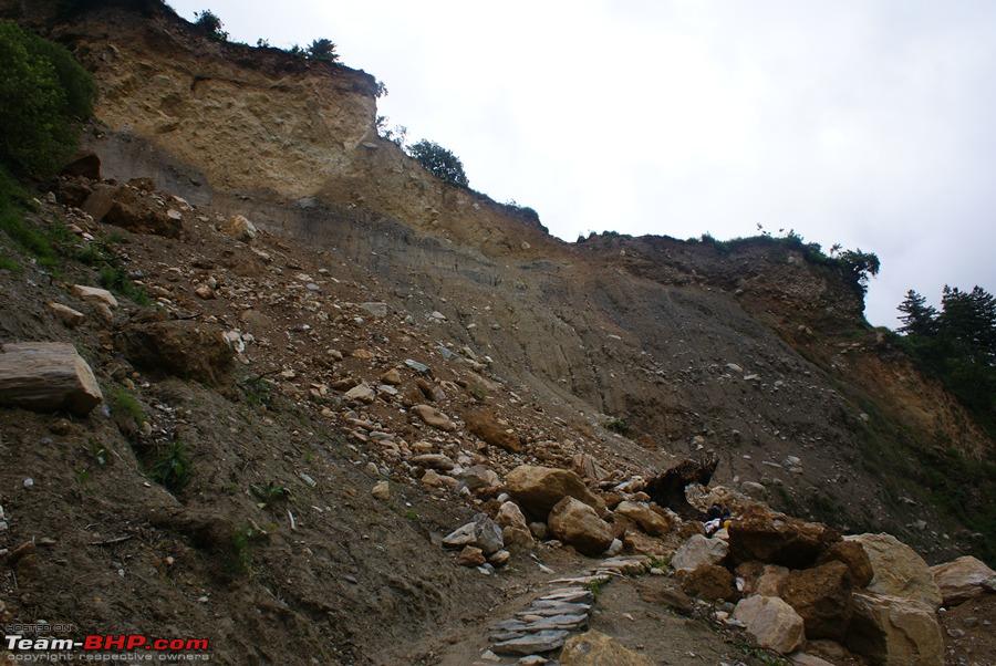 The camp of Budhi in sight!! 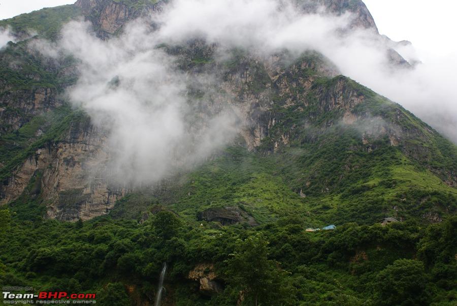 But we had to cross this bridge before reaching it 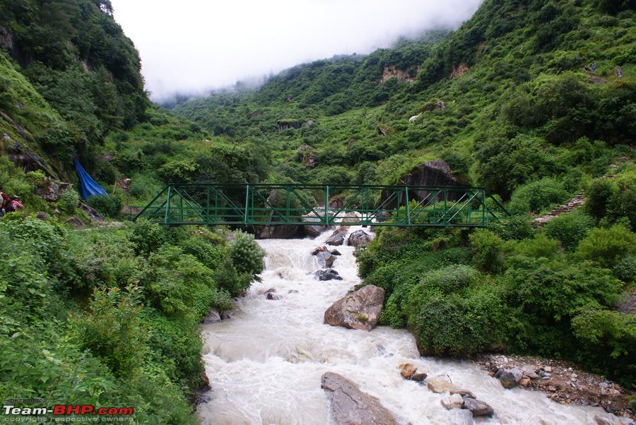 Budhi River  Finally Budhi after 11+ hrs 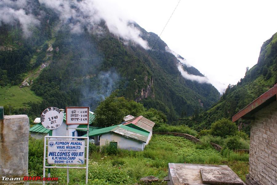 Budhi Camp 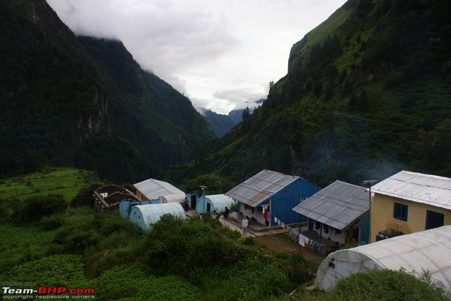 Breath taking views from the camp  A panoramic view from the camp 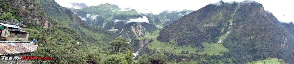 At these camps electricity is only available for 2 hrs and the charging points are at a premium  End Of Day8 |
|
| (13)
Thanks
|
| The following 13 BHPians Thank deky for this useful post: | amitwlele, ampere, dailydriver, flyingkolors, glomus123, haisaikat, Jakku, Nempuguru, Nohonking, phamilyman, Revy, saket77, yosbert |
|
31st August 2011, 13:50
| #49 |
| BHPian Join Date: Feb 2008 Location: Chennai/Kuwait
Posts: 502
Thanked: 354 Times
| Re: When I Went Walking To Tibet - Kailash Mansarovar Yatra-2011 Blessed Deky, Thanks for sharing MEA organized Kailash yatra. How are the chances of getting selected for this pilgrimage? Pure luck only? 230kms of serious mountain walk in 25days at these type of terrain must be quite demanding. what was the oldes age and youngest age of your batch? Last summer we did Kedarnath trekking 28kms up and down in 21 hours but was very tired as in the descending my left leg big toe started swelling and nail came off and regrew later. Kedarnath was my serious bakthi trekking. I want to do Kailash parikrama sooner. This walk to Kailash is great concept and very enticing route. India MEA Kaisha route is better than Nepal -Nyalam side Lancruiser version Kailash? Super photographs, good narration. Great scenery and nature's vastness! How difficult it was for you physically and from an urban living person's view point? |
|
| ()
Thanks
|
|
1st September 2011, 19:59
| #50 | |
| Senior - BHPian Join Date: Jul 2008 Location: Jaipur
Posts: 1,194
Thanked: 1,247 Times
| Day9: Budhi to Gunji (18kms) Quote:
2. The youngest was 23 and the eldest was 66, and believe me the eldest did the whole journey on foot. Understandably he did take a lot of time but his will power was there to be seen. 3. I also find the descend part very tricky. At steep descends the toe and the knees really hurt. Here is where a good and a comfortable pair of shoes comes in handy. 4. Will give a detailed comparison of both the routes later in a separate post. But if i had to do this trip again and had 30 days at disposal it would definitely be the MEA route. 5. Hmmmm.., well I have been quite active with sports and quite active otherwise also, active otherwise in the sense that I am quite an outdoor person. So the walking bit did not trouble me much. Also the fact that we were pretty well acclimatised as the ascend was gradual so physically it was not that challenging for most of us 6. Thank you for the appreciation. CONTD DAY9: BUDHI TO GUNJI Budhi: 2686 mtrs Gunji: 3166 mtrs Distance: 18 kms Time taken: 9 hrs I had a lay in today. Somehow I just did not feel like getting up in the morning and starting the walk. Maybe it was the fear of the steep 5 kms climb ahead that was making me delay it as much as possible or I knew that sooner or later we will catch up with the group. So while everyone left the Budhi Camp at 0500 hrs, my trekking partner and I only left the camp by 0600 hrs. The initial 5 kms of the journey was indeed very steep. If you notice the elevation map you will see that within that distance we had a height gain of almost 2000ft. The hill we were climbing was a proper forest with rocky trails, lots of trees and under growth. Luckily the weather was on our side and there was no rain, but it was misty and cloudy. Well walking through the clouds has its own charm. Slowly and laboriously both of us moved ahead. But we were fast enough to catch most of the group at Chialekh. Chialekh is also known as the valley of flowers as here you will find a lot of varieties of flower in their full bloom. After breakfast at Chialekh, the trail levels out and winds its way through beautiful meadows and streams . Just after breakfast is the first point where the passports of the Yatris are checked and details are entered. Even the porters and the pony men have to show their passes before they can move ahead. Chialekh to Garbiyang is more or less leveled and all the tiredness of the first few kms disappears in this stretch. I am not much interested in flowers hence for me it was more like walking in paradise. The low clouds, the lush green surroundings looking pristine with all the overnight rain, the sound of invisible streams hidden behind hills, the occasional mooing of the cattle grazing at the distance plus no strain of walking uphill all added up to the charm of being in paradise. Enjoying the vistas we soon reached Garbiyang. Garbiyang is an important village on the Indo-Tibetan and Indo- Nepal trade route. Here there is an old wooden bridge that traders use to take and get stuff from Nepal. Also lots of traders from here go to Tibet to get Chinese stuff when the trade opens (Indo-Tibetan trade route is only open for 4 months during the year). Garbiyang is also known as the Sinking Village and it was pretty evident why. The path suddenly became slippery and we were walking on inch deep slush. Apparently the village was built on Galcial residue hence a part of it keeps sinking all the time. We were told that at some places it has sunk upto 60 feet over a time span of 15 years. So houses once made on the save level are on different levels now. After passing another check point at Garbiyang we continued towards Gunji. As we gained height the changes in vegetation were quite evident. The thick forest had given way to more of green meadows and barren mountains. We were back to walking with Kali again but luckily the path at most of the places was not as treacherous as yesterday, it was more or less leveled. Suddenly a motor able road appeared from nowhere. It was not tarred but the mountain was cut and the path had been leveled. We could see the tyre marks on the path of a big truck so that meant that it is in use indeed. Walking on leveled path was a luxury after walking on stones and rocks for so many days. Soon we saw the camp of Gunji, but it was on another hill and we had to cross a river in between. Luckily the river had a bridge so getting on the other side was easy. By 1500hrs we had reached Gunji Camp. It was time for lunch and since we had two night stays here it was time to do some washing also. Gunji being at a height of almost 3200 mtrs there was no moisture in the air so drying of clothes was pretty fast. Evening time we went to the ITBP temple and had a great time singing Bhajans with the Jawans there. We realized that the Men & Women (ITBP employees women too) in Uniform are an enthusiastic lot. Even such harsh conditions and being away from family does not dampen their spirits. The bhajan evening was one of the most memorable evenings of the whole trip. Tomorrow will be a very important day for all of us. Tomorrow all the yatris will have to undergo another medical test to check the body parameters. Those who were to be found unfit at high altitude would have to return back and wont be allowed in Tibet. Three yatris from the previous batch had been rejected on medical grounds and that had made everyone even more tensed. So after dinner there was an emergency Yoga session by a yatri who was pretty good at yoga. Few Yoga Aasans were taught that would regulate your BP, heart rate and other things. It was a beautiful night sky. It was a totally clear and a moonless night. The stars were twinkling very bright but still the sight did not interest anyone and everyone wanted to have an early night. I wont say everyone slept peacefully as everyone was thinking of the medical tomorrow, so there was calm but an un-easy calm. After all no one wants to return mid-way from a journey!! PICS FROM DAY9 The route from Budhi to Gunji  Elevation of the route  Early morning mist 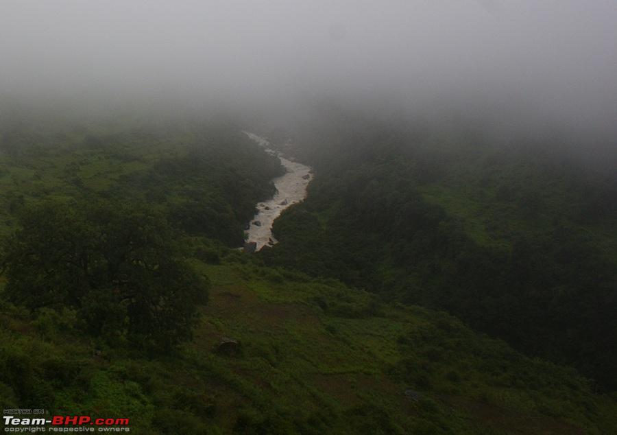 The steep climb that lay ahead. 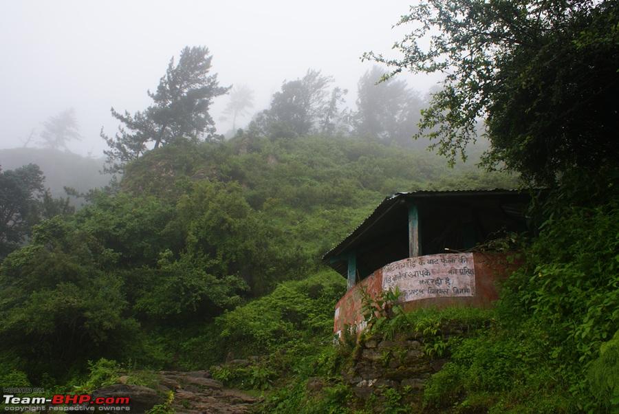 Camp of Budhi from where we started the climb 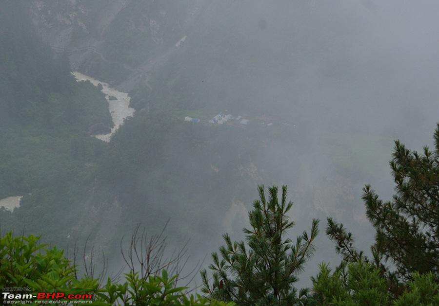 The camp got smaller and smaller as we went up higher  A walk in the clouds 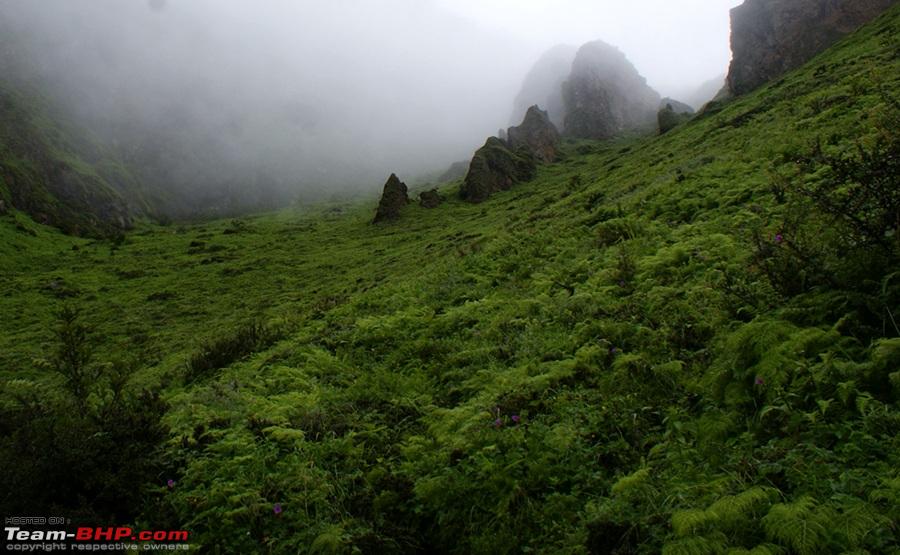 A yatri taking a break to enjoy the vistas. 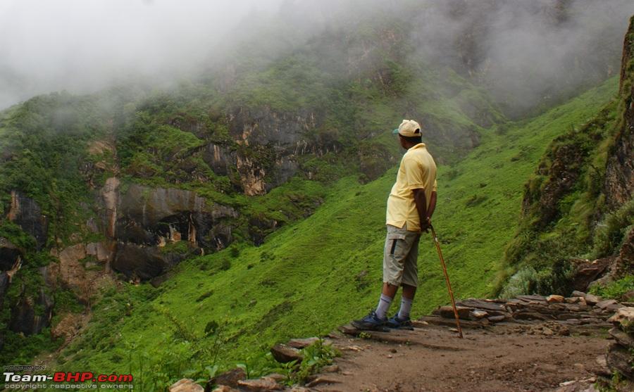 Soon we reached Chialekh  A panoramic view of Chialekh 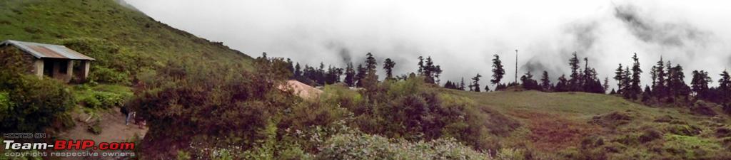 Chialekh checkpoint 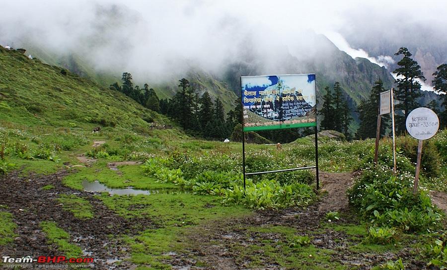 Some flowers shots and some snaps of the paradise   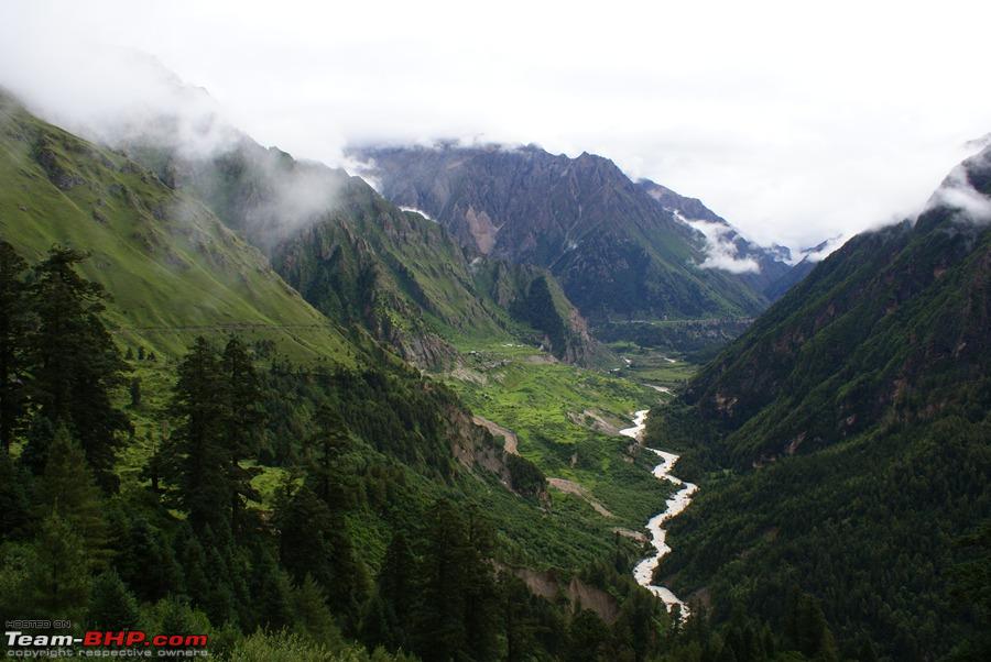  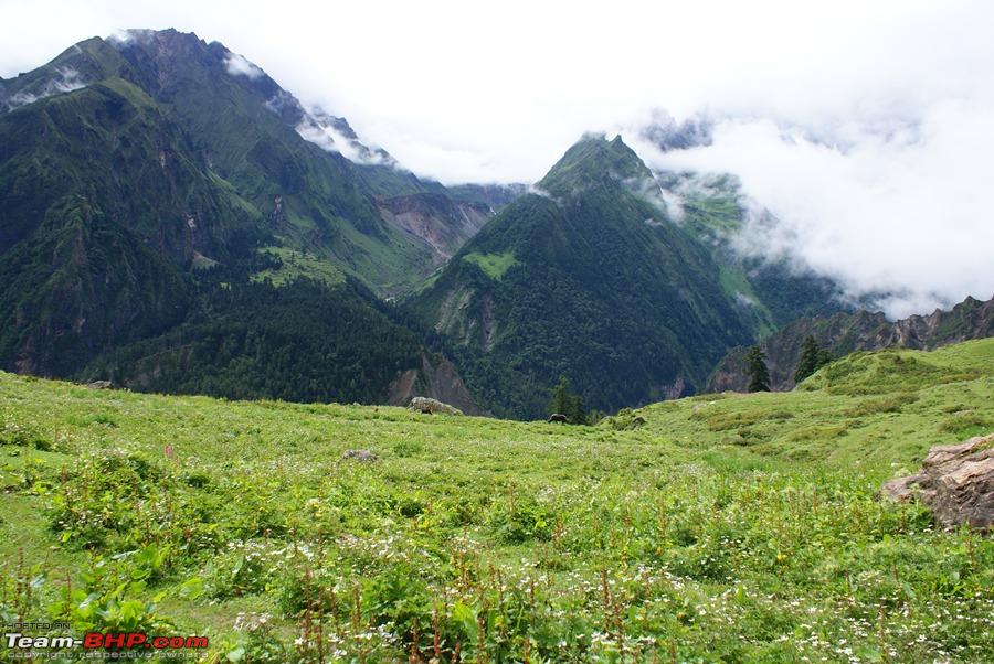 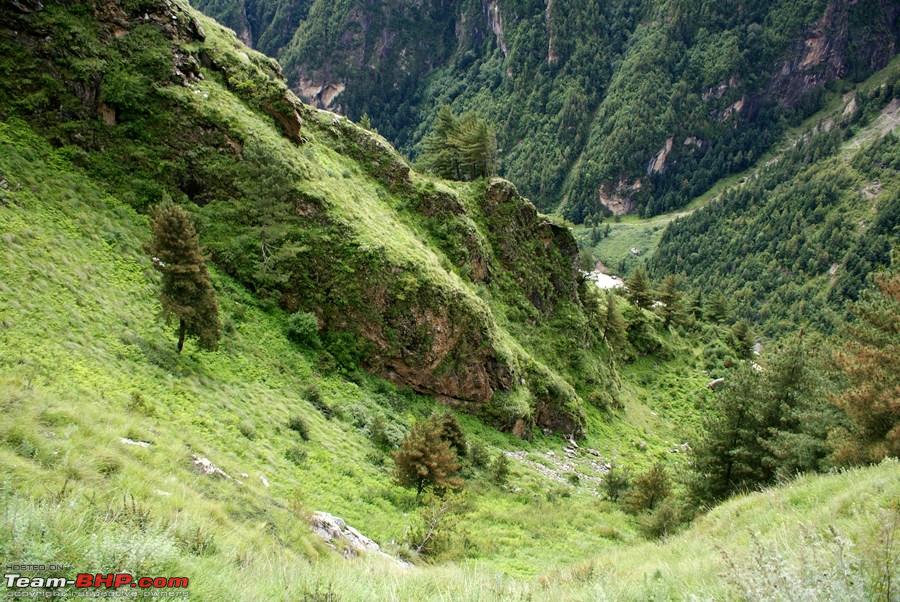 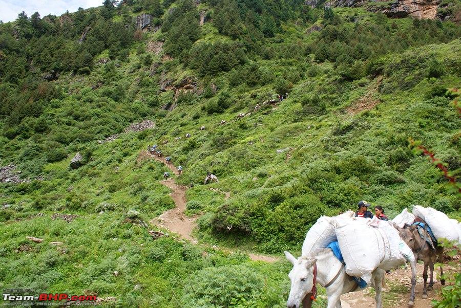 The "Sinking Village" of Garbiyang 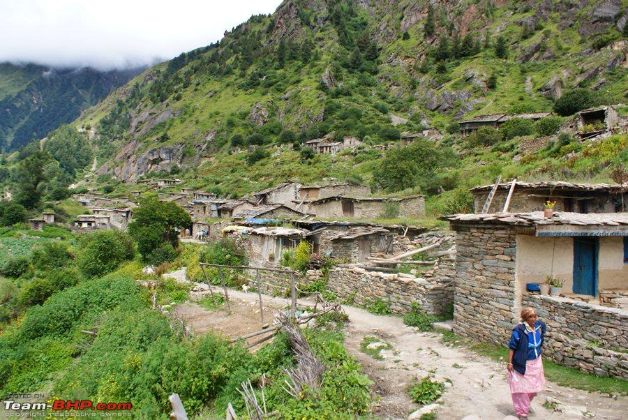 Another checkpoint where passport details are entered 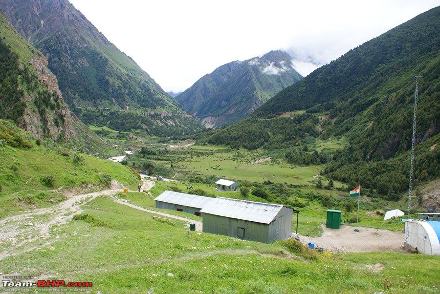 Back along the river Kali, we had to walk on the mountain side as could not afford to slip here 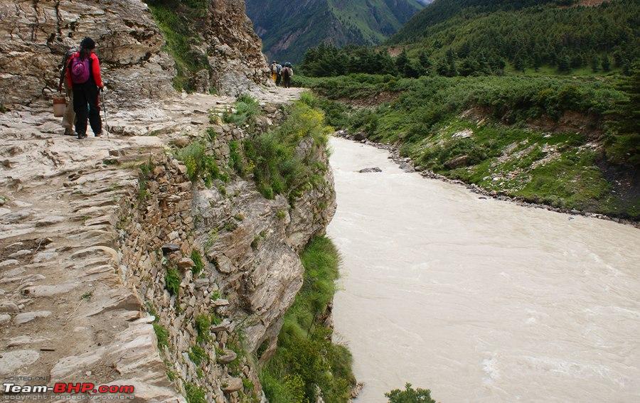  Change in terrain. Thick forests gave way to barren mountains  Motor-able road 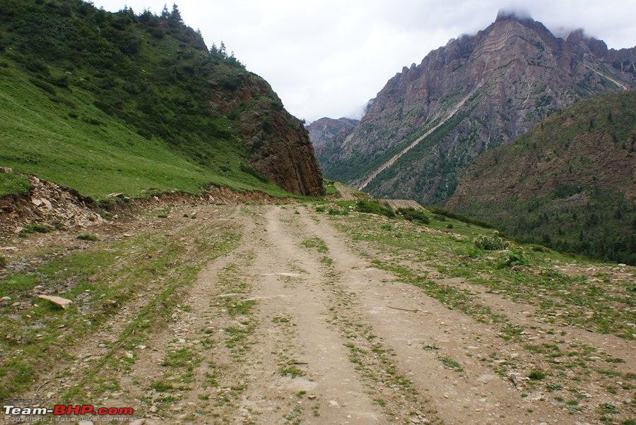 Other side of the river is Gunji Camp 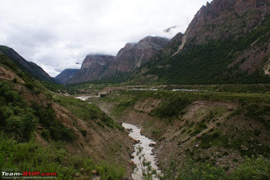 Enjoying the evening at ITBP temple 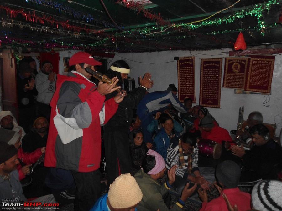 Before sleeping I Decided to make the most of a clear and a moon-less night!!! My hopeless attempt at shooting the stars   End Of Day 9 | |
|
| (9)
Thanks
|
| The following 9 BHPians Thank deky for this useful post: | amitwlele, ankurvirmani19, dailydriver, Jakku, Nempuguru, Nohonking, Revy, saket77, yosbert |
|
2nd September 2011, 10:33
| #51 |
| BHPian Join Date: Aug 2010 Location: Guwahati
Posts: 599
Thanked: 139 Times
| Re: When I Went Walking To Tibet - Kailash Mansarovar Yatra-2011 I had read your previous trip report through Nepal China and surprised to see that you did it once more. All the pictures here only makes ones hunger for atleast one such fulfilling trip even stronger. |
|
| (1)
Thanks
|
| The following BHPian Thanks San Phrangmung for this useful post: | deky |
|
2nd September 2011, 13:37
| #52 |
| Senior - BHPian Join Date: Jul 2008 Location: Jaipur
Posts: 1,194
Thanked: 1,247 Times
| Day9: Gunji - Rest Day DAY10: GUNJI Rest Day It was hardly a rest day, infact it was more hectic in the first part of the day than any other day. Every one since the morning was tensed about the medical checkup and the tension was quite visible on everyones face. Apart from the medical check up this was also supposed to be a day to acclimatise at 3000+ mtrs. After breakfast we had to carry our medical reports from Delhi to the ITBP camp which was next to our camp. The ITBP men had organized a briefing for us for the next part of the journey, the route and the precautions to be taken. After that our group was divided into 2 and the first half went in for medical and the rest went for planting trees in the ITBP grounds. Planting trees is a ritual that is carried out by the ITBP for all the groups. Well I got a walnut tree to plant! For the medical test, each yatri was being called by the serial numbers and when called they had to take their reports in the medical Inspection room (M.I. Room). In the MI room there was a team of 5 doctors checking your BP, the O2 levels, the heart rate, the X-ray and in accordance with the medical report from DHLI finally giving a verdict whether you need a re-examination later or no. Those on border line also were asked to come again at 1600 hrs for a re-check and the final verdict. Luckily all my parameters were ok except my Heart Beat that was a bit on the higher side. In the DHLI report it was normal so they presumed it must be due to the anxiety of being checked hence gave me a green signal to go ahead there and then. Out of a batch of 44, there were 14 yatris who were asked to come back for a re-check and believe me, their BP must have gone even higher after listening to this, so basically this waiting time must have been hell for them. After lunch while the 14 of them were doing all sorts of exercises to get their BPs down some of us decided to take a walk to the Gunji village that was about 2 kms away. The houses were all made of wood with some beautifull carvings on the doors. While coming back we stopped by a cricketing field and tried our hands at high altitude cricket. It was difficult running after the ball but still fun. By the time we returned from our walk the results of the medicals were out. Three yatris were told to stay back and return with the next batch going down. Those 3 yatris were almost in tears and were pleading with the doctors to consider them again, but the doctors were only doing their duty and their recommendations were for the yatris benefit only. My personal opinion on this medical check is that its a must and it should be done and the results should be accepted without any prejudice. After all its your own life at risk and no reason whether be religious or any other is more important than your own life. Also if something goes wrong with a yatri while in Tibet (like it did in our group) the medical facilities there are minimal and evacuating the yatri from China to India becomes an expensive affair. And if someone dies at Tibet side then you cant even bring the body back to India, you will have to cremate the body there and get the mortal remains. Hence its essential for the safety of oneself that doctors do a thorough job and declare yatri fit or otherwise for the trip ahead. The day ended on a sad note but there was still some work to be done before we slept. Gunji is another place where you can leave luggage behind and collect it on your way back. So luggage had to be arranged and us from the luggage committee had to count all the luggage and hand it over to the luggage contractor. It was time to sleep after dinner PICS FROM DAY10 Briefing at ITBP Camp 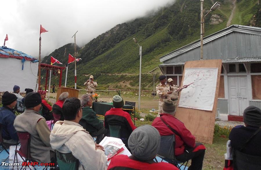 Enjoying hot tea and chips. The ITBP Men were great!! 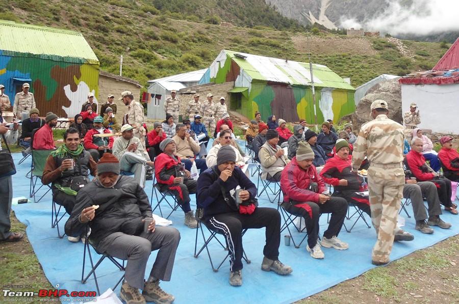 Planiting trees at "Mansarovar Van" at ITBP camp 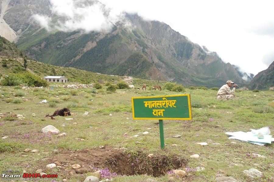  Yatris waiting for their turn for the medical 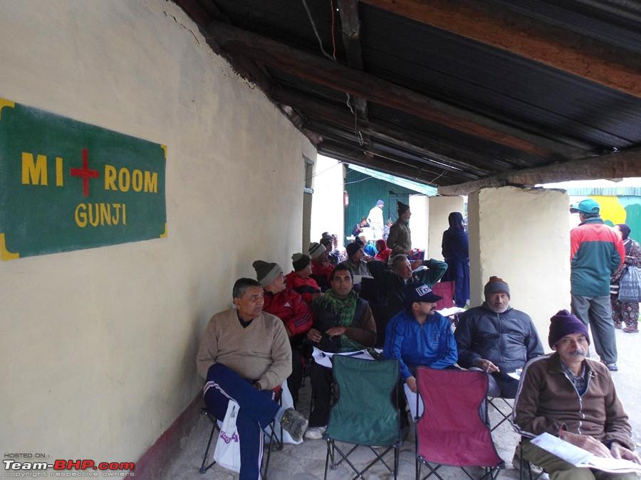 There is an SBI branch there too. It is online and you can withdraw a maximum of Rs5000/- in a day  View of our KMVN camp-Gunji from a hillock 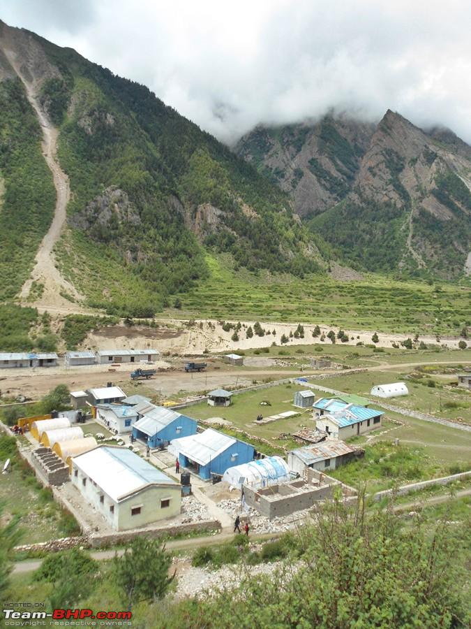 The cricket field 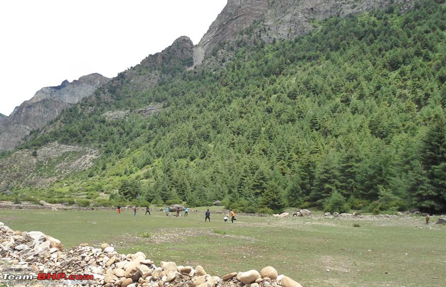 That ball did go for a six  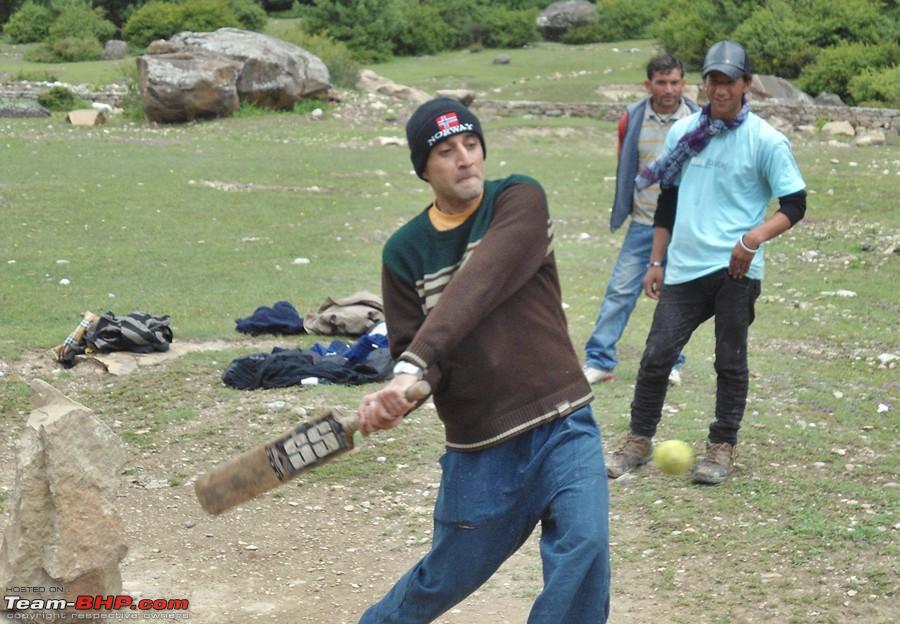 Panoramic view of Gunji village and the surrounding hills  Gunji Village  Beautifully carved wooden frames (knidly ignore the shoes please) 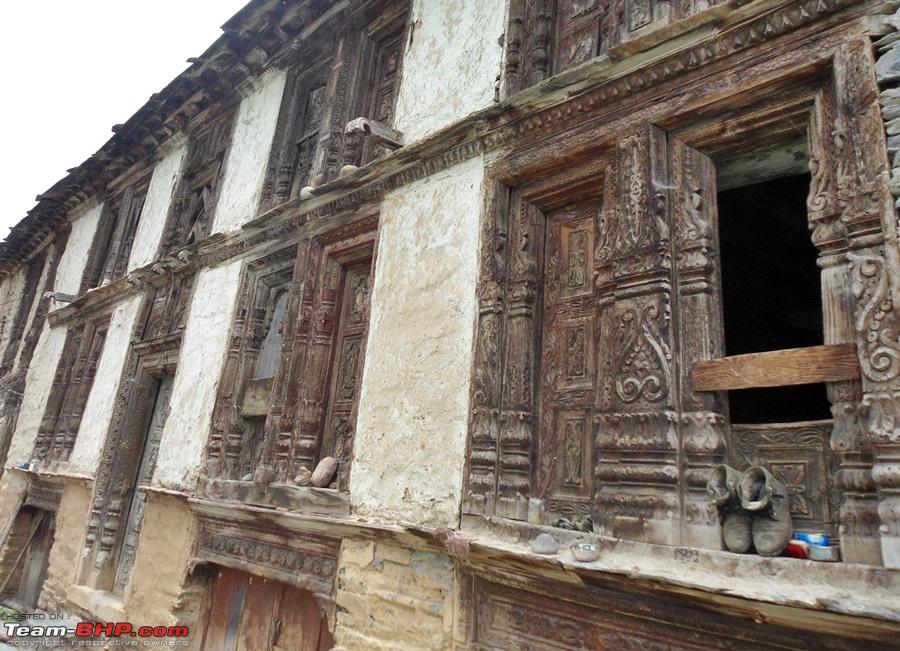 Milestones 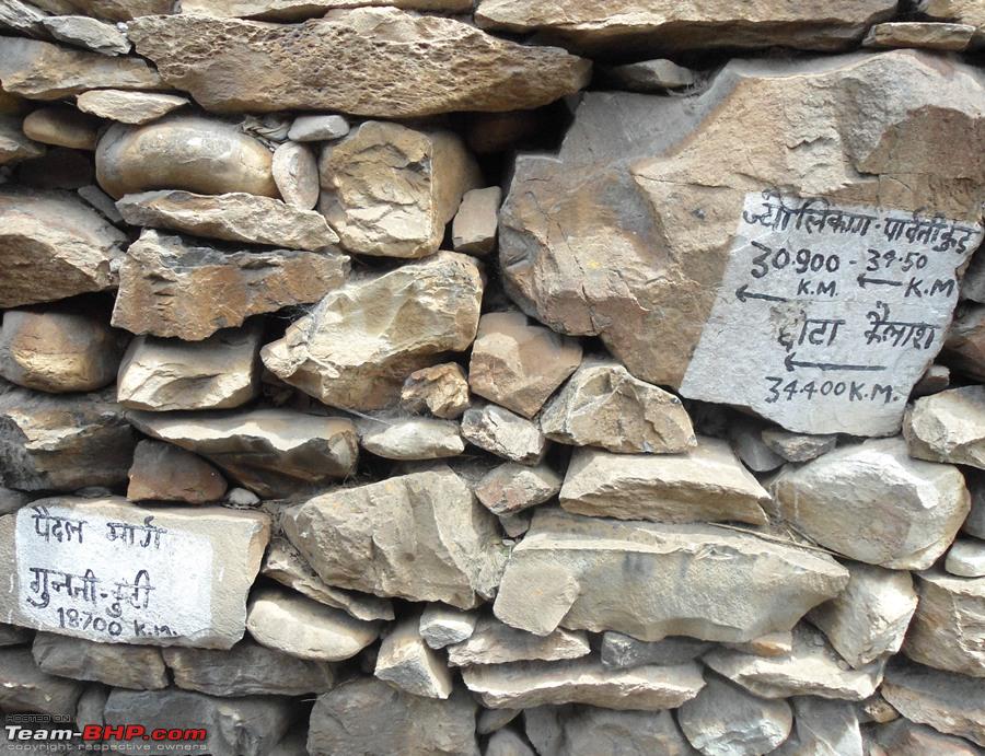 Walking back to our camp on the road, yes, trucks do ply here!! 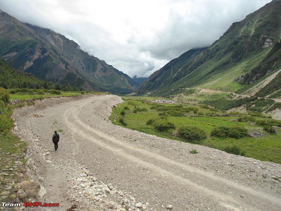 End of Day 10 |
|
| (9)
Thanks
|
| The following 9 BHPians Thank deky for this useful post: | ampere, dailydriver, flyingkolors, glomus123, haisaikat, Jakku, Nempuguru, Revy, yosbert |
|
2nd September 2011, 13:52
| #53 | |
| Senior - BHPian Join Date: Feb 2010 Location: Pune
Posts: 1,251
Thanked: 343 Times
| Re: Day9: Gunji - Rest Day Quote:
Medical Check up wait time would be agonizing. I was reminded of the wait time before the question papers are handed out during the exams  | |
|
| ()
Thanks
|
|
2nd September 2011, 13:57
| #54 |
| Distinguished - BHPian  Join Date: Sep 2008 Location: --
Posts: 3,552
Thanked: 7,262 Times
| Re: When I Went Walking To Tibet - Kailash Mansarovar Yatra-2011 Some very scary pics of the raging river deky! Is it possible/advisable to trek there(till budhi) on your own, in a small group maybe? Am really enjoying walking with you on this one! Keep going..  |
|
| ()
Thanks
|
|
2nd September 2011, 14:05
| #55 | ||
| Senior - BHPian Join Date: Jul 2008 Location: Jaipur
Posts: 1,194
Thanked: 1,247 Times
| Re: Day9: Gunji - Rest Day Quote:
I presume it is more to do with logistics than any thing else. As per the MEA the chinese side treats the dead body very in-humanely sometimes throwing it around or even unwilling to carry it so to avoid hurting sentiments they have decided that cremation will take care there and then. Apart from that even if they are nice to the dead, it will take atleast a few days before the body comes back to India and it wont be possible to stop the bosy from decaying!! Also Helicopter's from India are not allowed to land at Chinese side so the body will have to be carried atleast till India side. regards Quote:
If its advisable to go alone?? Well no, as the terrain there is difficult and you might require help at any point of time. And I believe small groups are always helpfull for the morale Last edited by deky : 2nd September 2011 at 14:11. | ||
|
| (3)
Thanks
|

| The following 3 BHPians Thank deky for this useful post: | amitwlele, dailydriver, Jakku |
|
2nd September 2011, 17:19
| #56 |
| Team-BHP Support  Join Date: Jan 2010 Location: Mumbai
Posts: 4,737
Thanked: 11,279 Times
| Re: When I Went Walking To Tibet - Kailash Mansarovar Yatra-2011 Fantastic narration. 230KM! Sounds crazy. But I guess its mind over body. Would love to do this journey. Adding to my "100 things to do before I die" list. Decky, hats off!! PS: In some snaps I see yatris casually dressed and in some others they are covered in many layers. Can you please throw some light around what were the temperatures at the various places? |
|
| ()
Thanks
|
| |
|
3rd September 2011, 18:33
| #57 | |
| Senior - BHPian Join Date: Jul 2008 Location: Jaipur
Posts: 1,194
Thanked: 1,247 Times
| Re: When I Went Walking To Tibet - Kailash Mansarovar Yatra-2011 Quote:
Gunji and after, even the days were cold. They must be like 12-14 degree Celsius with dry and chilly winds. So while walking it was ok, but as soon as you took a small break thats when you felt cold, hence in the day while walking it had to be a thermal plus a sweat shirt. Nights here were very cold, would be around 2-5 degree celsius. Lipulekh was chilling, must be below freezing. NOTE for all:- I might be going out of station so might not be able to udate the thread for a few days Sorry about that Regards | |
|
| (1)
Thanks
|
| The following BHPian Thanks deky for this useful post: | Jakku |
|
3rd September 2011, 20:32
| #58 |
| Team-BHP Support | Re: When I Went Walking To Tibet - Kailash Mansarovar Yatra-2011 @Deky, I just read your log in a single go (or I must saw was researching your log)! That is because just reading the story and seeing the snaps, don't suffice at all! One also needs to go through Google maps/wikimapia to trace the path that you traversed. So which GPS equipment did you have? Also that batting snap of yours is nice! Fun in those testing times! That's the spirit! And yes those snaps of Kali are real scary especially the ones where you had walk below the waterfall! Last edited by ampere : 3rd September 2011 at 20:33. |
|
| ()
Thanks
|
|
5th September 2011, 13:15
| #59 |
| Senior - BHPian | Re: When I Went Walking To Tibet - Kailash Mansarovar Yatra-2011 Truck Tracks? Where do they lead to or come from? Nearest road head? Plus there should be a rule here that You are not allowed outstation trips in between the fantastic travelogues. |
|
| ()
Thanks
|
|
8th September 2011, 12:46
| #60 | ||
| Senior - BHPian Join Date: Jul 2008 Location: Jaipur
Posts: 1,194
Thanked: 1,247 Times
| Re: When I Went Walking To Tibet - Kailash Mansarovar Yatra-2011 Quote:
Quote:
Am back now, and will be posting the next part soon. Thank you for your patience | ||
|
| ()
Thanks
|
|