News
Is it worth spending Rs 9,000 to get BMW Maps on my X5 updated

Currently, I am using Google Maps on my smartphone but it would have been great to have a useable built-in navigation in the SUV.
BHPian vivekiyer20 recently shared this with other enthusiasts.
I recently purchased a pre-owned BMW X5 (F15, 3rd gen). The built-in navigation in it is really outdated and hardly useful. It obviously doesn't have CarPlay. While currently I am making do using Google Maps on my mobile, it would have been great to have a usable in-built navigation. The current navigation system is a 2013 version and doesn't recognize any of the locations inputted.
On speaking to the BMW service advisor, he said it could be updated for a price of 9K INR. I'm wondering whether it is worth it. Does anybody have any ideas/tips regarding this?
PS: I am in Mumbai, if it helps.
Here's what GTO had to say about the matter:
Not at all and IMHO, that applies to all "inbuilt" navigation systems by car manufacturers. Google Maps is the best and offers up-to-date information, routes & traffic data. My smartphone fits perfectly in the cupholder with the screen facing me. If that's not the case with you, either rely on audio instructions or get a smartphone holder.
Here's what BHPian ssjr0498 had to say about the matter:
It's not worth it! If you plan on keeping the car, the local accessories dealer could help you with a retrofit MMI box basis your current I-drive model.
Here's what BHPian kdp had to say about the matter:
The BMW maps are not terrible, especially if they are up to date. There are times that I prefer BMW maps to Google maps. For Example, in Bangalore, as a non-local, I have been guided down increasingly narrow "Main" roads; while relying on Gmaps. BMW maps, for the same run on a subsequent day, on the other hand, kept me on the real main roads. (longer, but ultimately about the same travel time. And yes, Gmaps is set to minimise travel time). You do lose traffic information, but an integrated map has a nice interface and it's useful to see directions on the HUD.
It does not need to cost an arm and a leg to keep BMW maps up to date. it can even be free. I am assuming that you have a CIC Head unit if it's a 2013 map. I had NBT on my F25. DM me if you need guidance on how to go about it.
Check out BHPian comments for more insights and information.
News
New map app helps find the curviest roads around the world
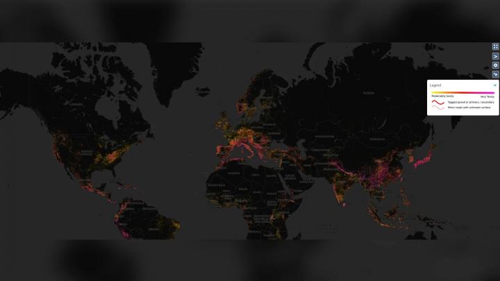
As per the app, Italy & Japan are the two best places in the world for driving enthusiasts.
According to reports, a new Map app allows driving enthusiasts to find the curviest roads around the world. The new app called 'Curvature' is a Waze-like Map for enthusiasts, providing a colour-coordinated map highlighting the curviest roads across the planet.
As per reports, the app separates the roads into three colours: Yellow, Red and pink. The roads marked in yellow are mildly curvy while the pink roads are very twisty, with more time spent driving through corners than straights. The red-coloured roads are somewhere in between. The app also allows users to zoom in on a particular road to see a breakdown of the road's sections. Each of these sections is given a numeric "curvature value" ranging between 0 - 10,000 to determine how twisty it is - with any road below 300 said to be boring.
Talking about the app, Curvature is said to use data sourced from OpenStreetMap - a community-driven mapping project. It also has a proprietary road-curvature algorithm to determine which roads are the most fun to drive. As per the app, Italy & Japan are the two best places in the world for driving enthusiasts, with most of their roads covered in pink. A few other countries also include Mexico, Peru and the USA, to name a few.
Source: TheDrive
- Tags:
- Indian
- International
- maps
News
Which are the features that should be a must have on Google Maps

There should be an option to select only main roads for a proposed route. Many times, Google ends up suggesting the shortest route which ends up being narrow lanes or streets.
BHPian contentedbloke recently shared this with other enthusiasts.
Dear all,
Most of us rely extensively on Google maps for our intercity and intracity travel guidance. While my personal experience with google maps has been largely great, there have been times where google has wrongly guided me and I wish there was something I could do about it.
Hence this post is to list down features which I think google should incorporate to improve its maps:
- There should be an option to select only main roads for a proposed route. Many times, Google ends up suggesting the shortest route which ends up being narrow lanes or streets when the main road option seems equally good or achievable. Those with large cars will appreciate this feature.
- There should also be an option where Google warns is that the roads are narrow. This is an offshoot of the previous point - sometimes, the destination route requires us to travel through narrow lanes which are more suited to bikes rather than cars and it would be good for google to warn us in advance so that we can decide on an alternative in advance.
- There should be a mechanism to immediately mark / call out a bad route so that this mistake does not occur in the future for other travellers. For example, while traveling from Bangalore to Sringeri, google suggested a short route from Belur to Jayapura - only half way we discovered that the roads were basically broken and riddled with potholes for.the entire 1 hr distance - if there was a way to inform google then and there, maybe google will not suggest this option to others as well.
- There should be a better way to guide us when we need to get on to a flyover or avoid it. Currently google uses language such as "take the slip road" or "take a slight right", without actually telling us that there is an upcoming flyover and we need to either get on it, or avoid taking it. This language is quite confusing and it would be helpful if google can be more specific.
Would request others to also post their suggestions on how to improve google maps further.
Here's what BHPian SILVER-ARROW had to say on the matter:
Have been through this situation which the OP has mentioned in point no.2. We were on a team building trip by a Bus to one resort in Pune. As usual we requested the best route on google maps and started following it. Only to realize that the road was going through narrow street at couple of locations where only single car can pass. It stuck upon us that google was suggesting the route which was for cars and we were travelling in a bus. Had to take a U-turn and closed the google maps for further directions. Took the normal highway and reached destination.
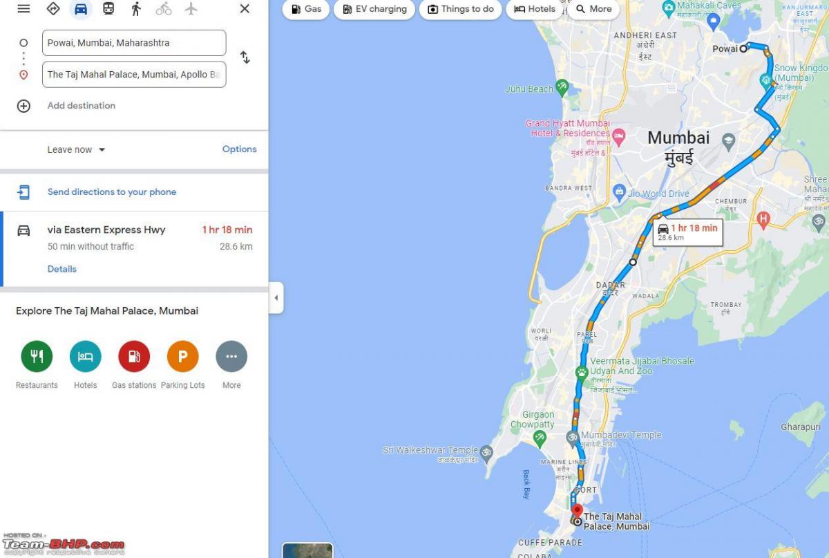
One feature I find missing on google maps in mobile is an option to drag the blue line of the proposed route and place it on other road, this feature is available on desktop. I always prefer to take route which has no bottlenecks even if it takes me 10/15 minutes more to reach a destination.
Google maps many times doesn’t show alternate route even if it is few minutes more then the proposed route. Is any Bhpian aware of this feature on Google maps in mobile?
Proposed route by Google Maps on desktop:
Manually modified route on Google Maps on desktop:

Here's what BHPian tilt had to say on the matter:
One option I would love (at least on iOS, maybe it's already there on Android) is to download offline maps for a specific route instead of picking all the squares manually and downloading them.
Re. OP's points 1, 2 qnd 3, there already is. The problem happens because all two-wheller people merely select destination and go. If they took a second more to select "Bike" as their mode of transport and then drive it would help car people.
Alternatively this will never happen) Google should keep Bike as the default mode of transport and car-people should manually select car.
Here's what BHPian ruzbehxyz had to say on the matter:
All the points mentioned in the previously mentioned posts are acceptable. On the other hand please note:
- Google maps is free and we must appreciate whatever google is giving us.
- Our country has still not given us Indian based maps even in 2022 and we are still relying on a foreign company. (Map my India is private).
- It’s very difficult for Google to update their maps continuously in a developing country like India where new roads are built by the hour. About 30 - 40 kms of National highways are built per day. A typical example is the Samruddhi expressway. It was opened and Google took some time to update the maps.
- Because of this technology, the present generation has lost the sense of direction and cannot actually read physical or paper maps because we totally rely on what the software says and blindly follow it.
- Google maps has one of the best features like offline maps where you can download particular maps and navigate using your phones GPS only without internet. Very useful in areas where you don’t have internet.
- Many Gmaps users blame the software but do not do some research before venturing in to a new place. Satellite mode is one way to check and plan your route and follow as per your wish.
Let me explain by an example:
You want to go from Himmatnagar to Ajmer on NH48 (old NH8), then you have to go through Udaipur. Google will take the shortest route and route you through the city which can be crowded and take more time. The alternate is the route marked on the right.
You can use ‘Add stop’ feature and just randomly select a spot on your route and then drive or physically pin a spot on the map:
Above is just an example and most people are aware of this.
Concluding this, there are still some Social media forums who abuse Gmaps sarcastically, even though they still use the base of Gmaps for their own so called maps and some of the members still drive Amrikan cars.
Above all let’s appreciate what we are getting for free and which has actually become part of our lives like some other apps eg. WhatsApp.

Here's what BHPian binand had to say on the matter:
I use Google Maps for two things:
- For navigation.
- To familiarise myself with the places I'm reading about (most recent was the description in a book of the drive from Miami to Key West via the Overseas Highway; it was fascinating).
Navigation use is almost entirely via Android Auto. And in this Google fails in a lot of areas (several failures are intentional I think). All of these fall under the broad heading of "Hey Google, I know this route better than you; you have to only watch the traffic condition". So:
- If I deviate from your selected route, respect my choice and reroute me. Don't try to find newer and innovative ways of pulling me back to your original chosen route.
- If you find a "faster route" just inform me and when I ignore you, sulk - but don't automatically reroute.
- Give me an option to pin my drive via a route - which is a directive to you to stay on that route and not even look if alternatives exist.
- Inform me well in advance of congestion, and not after you've made sure I've passed past all possible alternatives.
- I have disabled "Avoid tolls" for a reason. You don't have to show me toll avoidance dirt roads each of which would add 1h+ to my journey time and pollute my screen.
And my biggest problem now - please bring back the option to disable Labels (which would remove POIs, yellow/white road indicators and a bunch of other stuff from satellite view).
Here's what BHPian deep_bang had to say on the matter:
As far as point no. 3 by the OP is concerned, here is a way but right now it's too hard and as far as I know you need to come out of navigation to do this. What I prefer is a way you can mark a certain stretch of a road during navigation and go ahead and at the end of the trip (assuming you reached your destination) give other particulars required and finish the post detailing what was wrong.
Today it's just too hard to edit a mistake.
Check out BHPian commemts for more insights and information.
- Tags:
- Indian
- maps
- navigation
News
Seeking directions to your destination - Your preferences

We are so used to punching in the name of our destination on Google Map on our smartphones, that the thought of following directions like these seems almost blasphemous.
SS-Traveller recently shared this with other BHPians.
I just came across this rather interesting but old-fashioned set of directions to reach a resort.
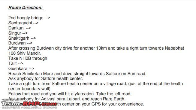
We are so used to punching in the name of our destination on Google Map on our smartphones, that the thought of following directions like these seems almost blasphemous. We follow the GPS directions, at times so blindly that we sometimes land into more trouble than we bargained for, or even imperil our lives.
Yet, even as late as at the beginning of the 21st century, we depended on paper maps, landmarks, and local pedestrians & shopkeepers to tell us where to go. Road trips involved possessing bunches of paper maps, which included Survey of India maps, TTK maps, and the mother of them all, the Automobile Association of Eastern India's Motoring Guide of India.
As someone who had begun embarking on roadtrips well before GPS and GMaps were household words, I am used to looking at paper maps and asking truck drivers as well as locals for directions to specific landmarks. The latter option (asking locals) may not be possible in many First World countries today with their freeways and lack of habitation along these roads, but it still has its uses in India. Today, I depend on Google Maps for most of the directions to an unknown destination, but I am not averse to asking locals either. Paper maps have all been stored away at home, and I don't even know where my copy of the Motoring Guide of India is - to me, paper maps nowadays are a cumbersome item to carry around and refer to.
So let us hear from you: when travelling to an unknown destination, how do you find your way?
Also, tell us anecdotes about your unique experiences while searching for directions, using whatever means (GPS, paper maps, asking locals).
Incidentally, the credit for showing us the directions to the resort goes to BHPian ALTIMAed. He asked the owner what stopped him from marking the place on Google Maps. Apparently, the last 250m of unsealed road to the resort have not been mapped by Google, and GMap consistently tries to send drivers through some other route if they follow a pin dropped on the place.
Thanks to SS-Traveller once again! Check out BHPian comments for more insights & information.
- Tags:
- Indian
- Google Maps
- maps
- navigation
News
GPS epoch rollover could affect some units

On April 6, 2019, the Global Positioning System (GPS) reached the end of an epoch – the navigational system reached its 10-bit week number (WN) limit and reset to 0. While modern GPS systems are not expected to be affected, some of the older units could face technical issues and stop working amongst other problems.
GPS systems are used the world over and are linked to the official Coordinated Universal Time (UTC) clock provided by the US Naval Observatory. The system uses a 10-bit number, which was last reset on August 21, 1999, or 1024 weeks ago. This event would occur much later than 1024 weeks after the modernisation of GPS system is complete. The WN counter will be increased to 13 bits.
Apart from navigation, other systems like cellular networks, utilities and industrial systems use GPS receivers for timing and control functions. While some modern units are programmed to accommodate this epoch change, it is recommended to check for firmware updates if you have any GPS unit.
Source: ArsTechnica
- Tags:
- Indian
- International
- GPS
- navigation
- maps
About Us