Team-BHP > Technical Stuff
Register New Topics New Posts Top Thanked Team-BHP FAQ


Reply
  Search this Thread
298,855 views
Old 29th August 2006, 15:05   #46
BHPian
 
prabuddhadg's Avatar
 
Join Date: Jan 2006
Location: Mumbai
Posts: 812
Thanked: 81 Times

I know nothing about GPS, so this question may sound foolish, but can any one tell me why we need GPS when we have cell phones? What I mean is that the cellular network can identify which cell someone is in, which of course is a large area, but generally, does the same thing with larger margin for error. So, if the cell operator can link the positions of the cell transmission towers with a map, you have a rough positioning system. Or is there a flaw in this? Other than the fact that in some forest with no habitation you would not expect a cell phone to work.
prabuddhadg is offline  
Old 29th August 2006, 15:14   #47
Team-BHP Support
 
tsk1979's Avatar
 
Join Date: Feb 2005
Location: San Jose, CA
Posts: 23,717
Thanked: 22,825 Times

1. Cell phones have a much larger margin of error
2. Triangulation will tell you your location w.r.t the towers, but not w.r.t map. If you started mapping, it would be a herculian task
3. It would work only where there is network.
4. If due to terrain you get signal from a far away tower you will get wrong info
5. Satellites are already up there. Reciever is a cheap and low cost solution.

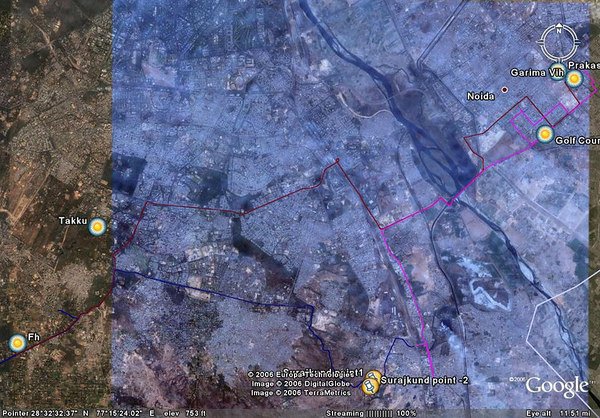
If you want to see the power of GPS, look at the TBHP meet report. By 7:30pm evening the pics will be up again, including the exact track taken by the noida convoy.
tsk1979 is offline  
Old 29th August 2006, 15:23   #48
BHPian
 
prabuddhadg's Avatar
 
Join Date: Jan 2006
Location: Mumbai
Posts: 812
Thanked: 81 Times

Quote:
Originally Posted by tsk1979
1. Cell phones have a ......., including the exact track taken by the noida convoy.
Thanks tsk1979 that helps clear some of the haze.
prabuddhadg is offline  
Old 29th August 2006, 15:33   #49
Ram
Senior - BHPian
 
Ram's Avatar
 
Join Date: Dec 2005
Location: Singapore, Mumbai, Nagpur
Posts: 2,166
Thanked: 219 Times

Quote:
Originally Posted by madhav
Guys I've a question... If a car with GPS system is stolen, can we find the location of the car using the same GPS system...maybe through another unit or something? Has anyone come across any such feature or product which will also double as a safety feature?
As tsk1979 said, GPS is a receiver not a transmitter.

For the car to be able to transmit data to you, you must build a system which integrates a mobile phone in the car.

When you send a "Where are you?" SMS to this system, it should take a GPS reading from the GPS receiver and send that reading by SMS back to you, telling you where it is located.

The earliest implementation that I remember (ten years ago in 1996), that integrated a mobile phone receiver and a GPS receiver was GM USA's OnStar system.

IBM has a 3-month internship program called Extreme-Blue for top-notch software engg. and MBA students. The students develop a technology and business plan for a new product or service that addresses an existing market challenge. Extreme-Blue students have filed for 270 patents.
An IBM Extreme-Blue student team developed OnStar in just three-months! Imagine that!

Some Cadillac models could be ordered with an optional factory-fitted OnStar system. You had to subscribe to the service provided by GM. It also had a phone handset, by which you could speak to OnStar people and ask for assistance. And OnStar people could call you when they detected that you'd had an emergency (e.g. collision and airbag deployment).

In 2001, a hands-free, three-button console became standard.
Later on, on many 2005 GM models it came as standard fitment.
GM claims that OnStar will be standard on all their US and Canadian models from 2007 onwards.

The world's security gurus are the Israelis and there's an Israeli company called
Ituran who provide high-tech tracking and location systems
http://www.ituran.co.il/

They provide location-based services: predominantly stolen vehicle recovery and
tracking services. They also sell the wireless communications products used in connection with those location-based services.
They have 3,75,000 subscribers in Israel, Brazil, Argentina and USA. They also sell to China and South Korea.

Ram

Last edited by Ram : 29th August 2006 at 15:36.
Ram is offline  
Old 29th August 2006, 16:08   #50
Ram
Senior - BHPian
 
Ram's Avatar
 
Join Date: Dec 2005
Location: Singapore, Mumbai, Nagpur
Posts: 2,166
Thanked: 219 Times

According to this article:
http://www.directionsmag.com/article.php?article_id=868

Gregory Payne, Director, Service Line Management and Enterprise Quality, OnStar, said, "...
..OnStar has 4 million customers and as of 2005, OnStar had achieved 100% brand recognition. OnStar is the poster child for telematics.

Here are a few of the basic average monthly calling statistics.
  • 20,000 roadside assistance calls
  • 3,00,000 routing support calls
  • 70,00,000 personal calls
  • 13,000 emergency calls
  • 23,000 remote diagnostics
  • 60,000 weather requests
On a typical Friday, OnStar handles 50,000 calls.

Since the introduction of OnStar in 1996 the company has updated its hardware six times...

Don't we have a long way to go, friends?
Ram

Here's some more interesting reading.
http://auto.howstuffworks.com/onstar.htm/printable

Last edited by Ram : 29th August 2006 at 16:12.
Ram is offline  
Old 29th August 2006, 21:34   #51
Senior - BHPian
 
gd1418's Avatar
 
Join Date: May 2006
Location: Gurgaon
Posts: 3,578
Thanked: 728 Times

I too have a Garmin iQue3200 GPS and had initially faced a lot of problems with the internal batteries running down quite fast when navigating. Asked my GPS seller for a solution since this model had no cigarrette charger. He got me a car inverter that plugged in the lighter socket and gave an AC output..!! My regular charger of GPS plugged into it and I have had no problems whatsoever.

Quote:
Originally Posted by naveendhyani
nice work mate. i will also go for 1. is there ny way u can power the unit thru the car's battery rather than running on internal batteries?
gd1418 is offline  
Old 29th August 2006, 21:37   #52
Senior - BHPian
 
gd1418's Avatar
 
Join Date: May 2006
Location: Gurgaon
Posts: 3,578
Thanked: 728 Times

How do you do this? I have a Garmin iQue3200. I travel a lot by road having very recently done - Gurgaon-Ajmer-Udaipur-Ahmedabad-Anand-Baroda-Daman-Mumbai-Lonavala-Khandala & back. How does one trace the route and import in google earth? Thanks in advance..

Quote:
Originally Posted by sharathjeppu
I had recently acquired a basic GPS receiver (Garmin Geko 201)

This time when I travelled Bangalore-Mysore-Mangalore-Bangalore, I decided to put this receiver on the dashboard of the Car to trace out the route that I took. Once I came back to Bangalore, I imported the route into Google Earth and this is what I got.


If you are interested you can download the "placemark" from here to view it on Google Earth.
gd1418 is offline  
Old 29th August 2006, 21:42   #53
Senior - BHPian
 
gd1418's Avatar
 
Join Date: May 2006
Location: Gurgaon
Posts: 3,578
Thanked: 728 Times
Mobile GPS in India

Go to Garmin.com and check out the dealer for India. They have two offices - one in Mumbai and the another in Delhi. They are the authorised dealers for garmin. and I have seen Mobile + GPS unit in one of their products display..

Quote:
Originally Posted by a4_attitude
Is there any GPS avialable in market which also works as mobile, its a great gadget, but worth only if it has mobile facility tooo, carrying two geomectry box is a tough job..
I heard some company launching it soon in India
any clues??
Cheers
Wadhwa Ajay
gd1418 is offline  
Old 29th August 2006, 21:47   #54
Senior - BHPian
 
gd1418's Avatar
 
Join Date: May 2006
Location: Gurgaon
Posts: 3,578
Thanked: 728 Times

I would like to correct this. Please visit www.asplindia.in. They are the autjorised delaers for Garmin in India and also sell updated maps for India, Delhi, Mumbai, bangalore, Pune.

Quote:
Originally Posted by sharathjeppu
The problem with most GPS systems is that they will not have maps to cover Indian Cities to use it for navigation like they do in the US or Europe. So having such a device may be very useful in those countries but not really useful in India. The reason why I choose Garmin is because of Google Earth Plus. This allows me to trace routes and locations that I want to and analyze it on Google Earth for what ever it is worth. So, technically, I am not really using it as a navigation system. More as an analysis tool.
gd1418 is offline  
Old 29th August 2006, 22:33   #55
Team-BHP Support
 
tsk1979's Avatar
 
Join Date: Feb 2005
Location: San Jose, CA
Posts: 23,717
Thanked: 22,825 Times

You dont need google earth plus. I change my lowrance .usr files to kml and open in normal google earth
here is one of the TBHP meet
tsk1979 is offline  
Old 29th August 2006, 23:09   #56
Senior - BHPian
 
black12rr's Avatar
 
Join Date: Dec 2005
Location: Ridin earth now
Posts: 1,278
Thanked: 339 Times

@tsk1979 thats awesum,btw what recevier/gps set you have ? and how to do what gd1418 asked ?

Thanks
black12rr is offline  
Old 29th August 2006, 23:29   #57
Team-BHP Support
 
tsk1979's Avatar
 
Join Date: Feb 2005
Location: San Jose, CA
Posts: 23,717
Thanked: 22,825 Times

I have Lowrance Expedition C.
What exactly do you intend to do?
tsk1979 is offline  
Old 30th August 2006, 12:30   #58
BHPian
 
a4_attitude's Avatar
 
Join Date: Sep 2005
Location: New Delhi
Posts: 508
Thanked: 101 Times

guys how to trace the route on google plus from Garmin???
a4_attitude is offline  
Old 30th August 2006, 13:16   #59
Team-BHP Support
 
tsk1979's Avatar
 
Join Date: Feb 2005
Location: San Jose, CA
Posts: 23,717
Thanked: 22,825 Times

google earth plus can recognize garmin and Magellen GPS systems easily when connected. If you have normal google earth you need to download data to your PC. Use GPS trackmaker or GPS Babel like software to convert the data into .kml and open the kml file in google earth.
tsk1979 is offline  
Old 30th August 2006, 21:52   #60
Senior - BHPian
 
gd1418's Avatar
 
Join Date: May 2006
Location: Gurgaon
Posts: 3,578
Thanked: 728 Times
garmin & google earth

This is total greek to me. Can u elaborate? A step-by-step would be much appreciated. I've a normal google earth (the one that you download for free) installed on my comp.

Quote:
Originally Posted by tsk1979
google earth plus can recognize garmin and Magellen GPS systems easily when connected. If you have normal google earth you need to download data to your PC. Use GPS trackmaker or GPS Babel like software to convert the data into .kml and open the kml file in google earth.
gd1418 is offline  
Reply

Most Viewed


Copyright ©2000 - 2024, Team-BHP.com
Proudly powered by E2E Networks