Team-BHP > Travelogues
Register New Topics New Posts Top Thanked Team-BHP FAQ


Reply
  Search this Thread
205,881 views
Old 1st August 2009, 14:32   #106
BHPian
 
tortoiseNhare's Avatar
 
Join Date: Dec 2008
Location: Guwahati
Posts: 536
Thanked: 90 Times

deky, hats off to you and your mother for visiting one of the most treasured destinations for an Indian and thank you a lot for sharing your experience in this thread. The photographs are truly amazing.

The river that you had seen there has originated from mansarovar rather than meeting the lake there and if I'm not mistaken, that should be the origin of our own Brahmaputra river.

Finally, this is another very significant reason why I am proud to be an Indian.

Quote:
Originally Posted by deky View Post
Though in India we might not have as good roads as what China may make or we make just one sea link in 10 years as oppose to Chine making 3 in 10 years, but the most important is that we have our rights as a democracy, ours is a free country. How ever we choose to use our freedom and our rights is on us.
tortoiseNhare is offline   (1) Thanks
Old 1st August 2009, 15:40   #107
BHPian
 
Join Date: Dec 2005
Location: SF Bay Area
Posts: 222
Thanked: 3 Times

@ASHISH,

If you click on the picture or any attachment, it opens in a new window (or tab) and then you can right click -> save image to save the image to your local disc.

Inherent shortcoming of this is only 1MB is allowed per image, so image size is quite small.

@deky
Mind-blowing !!
abhijitaparadh is offline  
Old 1st August 2009, 15:46   #108
Senior - BHPian
 
chevelle's Avatar
 
Join Date: Apr 2008
Location: sacto
Posts: 1,299
Thanked: 553 Times

Quote:
Originally Posted by abhijitaparadh View Post
@ASHISH,

If you click on the picture or any attachment, it opens in a new window (or tab) and then you can right click -> save image to save the image to your local disc.

Inherent shortcoming of this is only 1MB is allowed per image, so image size is quite small.

@deky
Mind-blowing !!
and the saved image can be resized to higher resolution using many photo editing software. i prefer irfanview for such simple resizing. and while doing so
you can increase the quality too so on resizing it doesn't get 'pixalated'.

hope this helps
chevelle is offline  
Old 1st August 2009, 15:56   #109
Senior - BHPian
 
deky's Avatar
 
Join Date: Jul 2008
Location: Jaipur
Posts: 1,194
Thanked: 1,251 Times

Quote:
Originally Posted by tortoiseNhare View Post

The river that you had seen there has originated from mansarovar rather than meeting the lake there and if I'm not mistaken, that should be the origin of our own Brahmaputra river.
No, This river was definately joining the lake. I am saying this as I saw the flow towards the lake. Infact while we did the parikrama I was trying hard to spot a stream that was leaving the lake but could not spot any, all were joining the lake.

You are right about Brahmaputra originating from Kailash-Mansarovar area, but as per the knowledge I gathered you can not pinpoint the source of Brahamaputra. Its the whole system around that collaborates finally to be called Brahmaputra.

Here is a map around Mansarovar, downloaded from the net to explain you better. The map shows where the rivers Brahmaputra, Indus and Sutlej originate.
Attached Thumbnails
Traversing The Tibet Plateau To Mount Kailash-mansarovar_map.jpg  


Last edited by deky : 1st August 2009 at 15:58.
deky is offline   (1) Thanks
Old 1st August 2009, 16:03   #110
BHPian
 
tortoiseNhare's Avatar
 
Join Date: Dec 2008
Location: Guwahati
Posts: 536
Thanked: 90 Times

Quote:
Originally Posted by deky View Post
No, This river was definately joining the lake. I am saying this as I saw the flow towards the lake. Infact while we did the parikrama I was trying hard to spot a stream that was leaving the lake but could not spot any, all were joining the lake.

You are right about Brahmaputra originating from Kailash-Mansarovar area, but as per the knowledge I gathered you can not pinpoint the source of Brahamaputra. Its the whole system around that collaborates finally to be called Brahmaputra.

Here is a map around Mansarovar, downloaded from the net to explain you better. The map shows where the rivers Brahmaputra, Indus and Sutlej originate.
That was a nice illustration. Thanks for the clarification regarding the origin of the Brahmaputra.
tortoiseNhare is offline  
Old 1st August 2009, 16:08   #111
Team-BHP Support
 
Rudra Sen's Avatar
 
Join Date: Apr 2004
Location: Bangalore
Posts: 11,657
Thanked: 6,622 Times

One of the best Travelogue here.

Lot of your pictures have tremendous potential. You do have a serious collection now.
Rudra Sen is offline  
Old 1st August 2009, 17:00   #112
BHPian
 
isldhn's Avatar
 
Join Date: Nov 2008
Location: Ludhiana
Posts: 285
Thanked: 147 Times

@Rudra: Sir, Just for information sake, what did you mean when you said ,many photographs have tremendous potential? Can someone approach Deky for using his photographs for some magazine or editorial? And in that case can he expect some monetary compensation for that? This is just for my information :-)
isldhn is offline  
Old 1st August 2009, 17:35   #113
Team-BHP Support
 
Rudra Sen's Avatar
 
Join Date: Apr 2004
Location: Bangalore
Posts: 11,657
Thanked: 6,622 Times

Quote:
Originally Posted by isldhn View Post
what did you mean when you said ,many photographs have tremendous potential?
Some of the pictures here can be improved big time.
Quote:
Can someone approach Deky for using his photographs for some magazine or editorial? And in that case can he expect some monetary compensation for that? This is just for my information :-)
This is entirely up to him and I won't suggest or comment anything here.
Rudra Sen is offline  
Old 1st August 2009, 18:00   #114
Senior - BHPian
 
deky's Avatar
 
Join Date: Jul 2008
Location: Jaipur
Posts: 1,194
Thanked: 1,251 Times
About Mount Kailash

Mount Kailash 6740mtrs, is situated to the North of Himalayn barrier, wholly withing Tibet. It is the perfect mountain with awesome beauty and 4 great faces.

It is also believed that when the two continental plates met (the big bang theory) it was here that the plates met hence Kailash was born. So its also considered to be the centre of the universe or the navel of the world around which the world revolves.

Over the centuries piligrims from various religions have faced innumerous hardships to reach Mount Kailash for enlightenment. Mt. Kailash is revered to Hindus, Jains, Buddhist and Bon religion alike.

Hindus
Hindus consider Mt Kailash to be the earthly manifestation of Mt. Meru, their spiritual centre of the universe. Kailash is decribed as a pillar whose roots are in deepest hell and its summit kissing the heaven above. On the top lives the most revered God, Shiva and his consort Parvati. Mt Kailash is isolated from other High mountain peaks in the area and is surrounded by small peaks. This exceptional isolation and its peculiar contours of black granite makes the Mountain to stand apart and give the appearance of Shivalinga. Also due to this isolation a parikrama is possible around the mountain.

Tibetans
For the Tibetans its also known as Kang Rinpoche or "the precious jewel of the snow" Its said that from four faces of Kailash flows a river that finally flows in all 4 cardinal directions. Strangely enough 4 major rivers do originate around Kailash

1. North :- River Of Lion Mouth - Indus
2. East :- River Of Horse Mouth - Sutlej
3. South:- River Of Peacock Mouth - Karnali
4. West :- River Of Elephant Mouth - Brahmaputra or Yarlong Tsangpo

Jains
For the Jain's its the place where their first Prophet, Rishabhdeva achieved enlightenment.

Bon
For the Bon's (a part of Buddhism) it is considered that their founder, Shanrab, descended from heaven here. As opposed to the others, the followers of Bon religion do the parikrama around Kailash in an anti-clockwise direction

PARIKRAMA OR KORA OF MOUNT KAILASH

As mentioned earlier, due to its peculiar isolation, Parikrama or Kora as known in Tibetan, of the Holy Mountain is possible. Its believed by the Tibetans that single Kora washes the sins of life time and after 108 Kora's one attains Nirvana. And after 21 Kora's one is eligible to do the inner Kora on the higher reaches of Kailash.

Usually piligrims take 3 days to complete the 52kms of the Parikrama by foot or Pony. Some devout Tibetans do this in a single day.

Its very important to know whats instore, during the parikrama and then decided whether you are upto it before hand or not. Mental conditioning is a must.

So here is a bit about the parikrama before we actually started it.

Attachment 168199

Parikrama Day 1: Darchen to Derapuk 20kms
The first 8 kms of the parikrama is done by jeeps. The jeep will drop you at Tarboche and from there you trek the rest 12 kms to Derapuk Gompa. The route is a gradual ascend with some ups and down along the Lham Chu river. It takes approximately 4-5 hrs to do this journey.

If for some reason, anyone not interested in doing the Kailash parikrama can do the parikrama around Yam Dwaar at Tarboche and then return back to Darchen and wait for the rest of the group to return.

Parikrama Day 2: Derapuk To Zutupuk, 18kms
This is the most ardurous of the days as this involves crossing th Drolma La at 5680mtrs or 19,500ft. Even if you have done a pony the steep ascend of about 4kms before the Drolma la and the steep descend after, will have to be done on foot. It gets a bit tricky doing this on looses stones and boulders, but here the poters are of a great help

Also just after Drolma la you cross the highest fresh water lake, Gauri Kund 5608mtrs. Gauri Kund or The Emerald lake or The Lake of Compassion is believed to be the place where Ganesha acquired his elephant head.

Completing this trecherous trek of 18 kms take 10-12 hrs and by evening you reach ZutulPuk camp

Parikrama Day3: ZutulPuk to Darchen 14kms
This is the simplest of the 3 days as is mostly done on plain lands. The total trek on foot or pony is of 10 kms and at the end there are the jeeps waiting for you and you cover the last of the 4 kms by road. This takes around 3-4 hrs
Attached Thumbnails
Traversing The Tibet Plateau To Mount Kailash-prikramamaphand.jpg  

deky is offline   (2) Thanks
Old 1st August 2009, 18:06   #115
Senior - BHPian
 
deky's Avatar
 
Join Date: Jul 2008
Location: Jaipur
Posts: 1,194
Thanked: 1,251 Times

Quote:
Originally Posted by Rudra Sen View Post
One of the best Travelogue here.

Lot of your pictures have tremendous potential. You do have a serious collection now.
Thank You Sir, This coming from a great photographer is very satisfying. I know the photos can be improved a lot but I am still learning and dont have any clue about PP. I just resized or cropped them.
deky is offline  
Old 1st August 2009, 20:03   #116
Distinguished - BHPian
 
Sam Kapasi's Avatar
 
Join Date: Jul 2005
Location: Mumbai (but wat
Posts: 7,000
Thanked: 2,451 Times

Gorgeous photos and a beautiful travelogue. You had me hooked. Thank you.
Sam Kapasi is offline  
Old 1st August 2009, 20:07   #117
Senior - BHPian
 
deky's Avatar
 
Join Date: Jul 2008
Location: Jaipur
Posts: 1,194
Thanked: 1,251 Times
Day10: Darchen To Derapuk (4910mtrs) , Parikrama Day1

It was obviously one of the most exciting day of the journey for all the yatris. Today would be the first day of the parikrama around Mt. Kailash. For mother and I it was more exciting because of the adventure involved in it rather than the religious sentiments. Both of us were just happy that we had got to see Kailash and were able to have a dip in Mansarovar, and now doing the parikrama was a bonus.

Moreover I was quite certain that we would be able to do the parikrama safely as so far we didnt have any symptoms of AMS and more over on the safer side I had made mom to do the parikrama on a pony.

During the course of the morning Tenzing, our guide, also responsible for arranging the ponies and porters came and gave us the news that due to the rush of yatris, we had not got enough ponies. He was just able to manage 4 ponies out of the 10 we had requested. "Netaji" decided that all the 3 ladies would get a pony each and since he had made this complicated decision the last pony would be for him.

We started from Darchen for Tarboche, the starting point of Kailash Parikrama by foot, at around 9.30am. It didnt take us long to cover the 8kms journey by jeep and by 10 am we were at Tarboche. We had eaten breakfast and packed lunch in plastic bags were handed over to us.

It was a very cloudy day and all hills were covered with clouds, we were hoping that during the day the cloud cover would dissapear.

Our first halt was at Yam Dwaar, its believed that to please the Yam God one should do parikrama of this place thrice, so we did the rituals. It was still very cloudy and the beautifull sight of Kailash from Yam dwaar eluded us.

MOM AT YAM DWAAR
Traversing The Tibet Plateau To Mount Kailash-dsc01455a.jpg

PREAYER STONES AND YAK HORNS AT YAM DWAAR
Traversing The Tibet Plateau To Mount Kailash-dsc01455b.jpg

Finally at the starting point preperations were under way. Tibetan porters were given to everybody who had requested for and the 3 ladies and Mr Netaji got a horse.

THE STARTING POINT
Traversing The Tibet Plateau To Mount Kailash-dsc01456.jpg

A GOMPA ON TOP OF THE HILLS AT TARBOCHE
Traversing The Tibet Plateau To Mount Kailash-dsc01458.jpg

PONIES FOR THE YATRIS
Traversing The Tibet Plateau To Mount Kailash-dsc01457.jpg

I could not believe that some of the porters were 14-15 yrs of age and that also girls. They were definitely tough to be able to carry 10-12 kgs of weight at such heights.

Once the yaks were loaded with the food supplies and water for 3 days, our group of 21 yatris, 4 on horses and the rest 17 on foot plus 4 sherpas and 2 tour managers and 1 Tibetan guide started our parikrama around mighty Kailash.

MOUNTAIN RIDGES
Traversing The Tibet Plateau To Mount Kailash-dsc01459.jpg

MOM AND I BEFORE STARTING OUR PARIKRAMA
Traversing The Tibet Plateau To Mount Kailash-dsc01460.jpg

The route all along was between two mountain ridges and the river Lham chu flowing in between. It was still cloudy and threatening to rain any time but since we were walking it was nice till it did not rain. Anyways our Guide had told us that there are only 5% chance that it will rain. He said that either it will snow or nothing would happen. Snow wouldnt be so bad as atleast one wouldnt get wet.

PARIKRAMA ROUTE ALONG LHAM CHU RIVER
Traversing The Tibet Plateau To Mount Kailash-dsc01467.jpg

OUR PORTERS WERE EVER READY TO HELP US
Traversing The Tibet Plateau To Mount Kailash-dsc01466.jpg

Slowly slowly we ascended upwards. I had been practising for this for a while now, and all the stamina gathered during exercising was proving to be very helpfull now. With few breaks in between and lots of chanting of "Om Namah Shivaya" from fellow yatris the spirits were kept high and we continued moving.

YATRIS TAKING A BREAK AND THE STARTING POINT IN THE BACKGROUND
Traversing The Tibet Plateau To Mount Kailash-dsc01468.jpg

MOM ON THE MIDDLE PONY AND THE OTHERS WERE FOLLOWING US
Traversing The Tibet Plateau To Mount Kailash-dsc01469.jpg

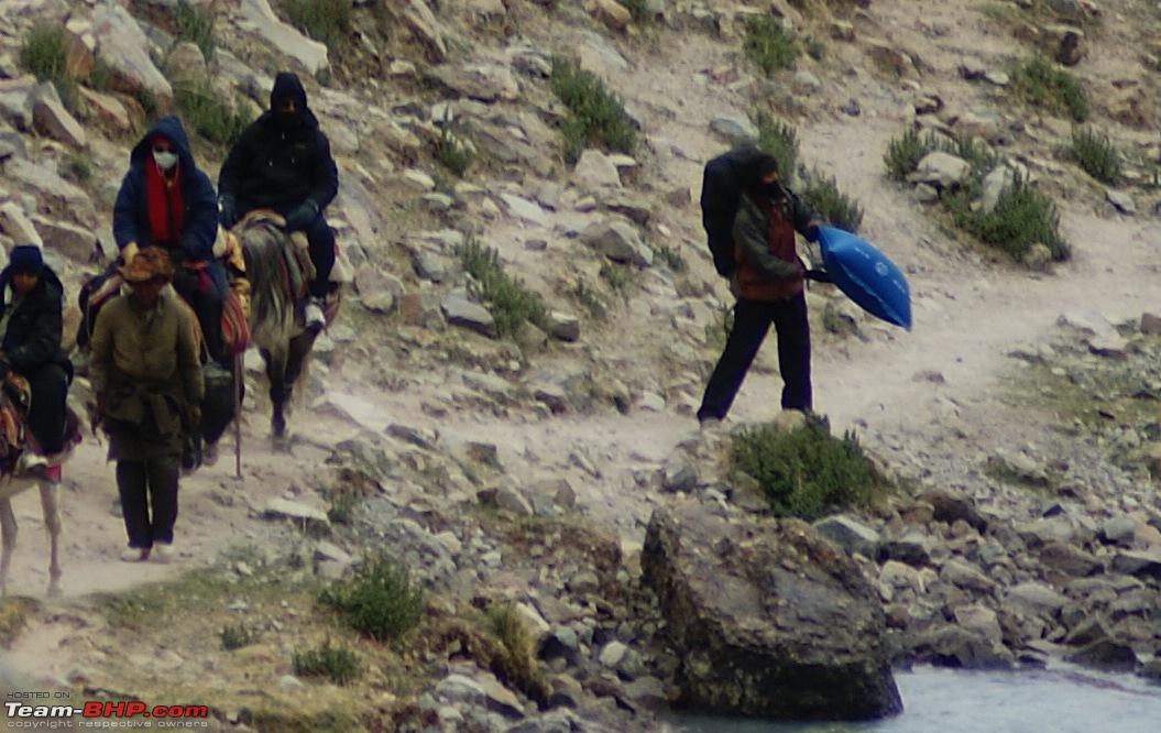
SHERPA CARRYING AN OXYGEN PILLOW (SEEN IN BLUE)
Traversing The Tibet Plateau To Mount Kailash-dsc01469a.jpg

A SMALL WATERFALL EN ROUTE
Traversing The Tibet Plateau To Mount Kailash-dsc01470.jpg

We spotted some animals climbing up the sheer cliff on the sides. These animals turned out to be Himalayan gazelles beautifully camouflaged by the rocks. Them able to climb straight mountain faces with so much of ease just bewildered me.

CAMOUFLAGED ANIMALS
Traversing The Tibet Plateau To Mount Kailash-dsc01473.jpg

THEY WERE MOUNTAIN GAZELLES
Traversing The Tibet Plateau To Mount Kailash-dsc01474.jpg

We decided to stop for lunch in between. This was a well deserved rest for us, the sherpas, the porters and the ponies alike. Individual packed lunches were opened and were shared with even the porters

TAKING LUNCH BREAK
Traversing The Tibet Plateau To Mount Kailash-dsc01471.jpg

THE JOURNEY AHEAD
Traversing The Tibet Plateau To Mount Kailash-dsc01476.jpg

In between there are a few prayer points from where Kailash is visible. Prayer flags adorn these view points and The Tibetan's do a full prostate pranayams here. Also you can see some people passing you by, doing the anti-clockwaise parikrama, these are people from the Bon religion.

DARK CLOUDS ON THE MOUNTAINS
Traversing The Tibet Plateau To Mount Kailash-dsc01477.jpg

TIBETANS DOING PROSTATE PRANAMS TO KAILASH
Traversing The Tibet Plateau To Mount Kailash-dsc01479.jpg

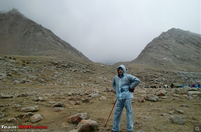
After about 3 hrs of walking it started to drizzle lightly, hoping that it would stop we continued our trek forward. But soon it became pretty heavy and by the time I could reach for my rain coat in the ruck sack I had got some what wet. This was not good as with the rain it got pretty chilly too.

CLOUDS COVERING MT KAILASH
Traversing The Tibet Plateau To Mount Kailash-dsc01478.jpg

Finally I wore my rain coat and we proceeded. Mom was left behind with others as they had stopped when the rain started, so it was just Amit and I in front with our porters.

HAD TO WEAR MY RAINCOAT AS IT STARTED TO DRIZZLE AND WAS COLD
Traversing The Tibet Plateau To Mount Kailash-dsc01479a.jpg

After about 4 hrs of walking, at a distance we could see our destination for the day, Derapuk Gompa. Actually the Gompa is on the left bank of the river but we were to stay on the right bank. Also our guide had booked guest rooms in advance or else we would have to stay in tents here and that too in all this rain.

Finally Amit and I reached the guest houses. These were huts made of stones and with thatch roofs, but at least they were not leaking. As soon as I enetered the room I decided to take off my rain coat and my jacket and change my wet socks and relax and wait for Mom.

JUST BEFORE DERAPUK, TILL NOW KAILSH WAS COVERED WITH CLOUDS
Traversing The Tibet Plateau To Mount Kailash-dsc01479b.jpg

The plan was to have hot tea when the kitchen equipment arrives and if it stops raining to cross the river and visit the Gompa.

Mom arrived after 10 minutes or so. She was not able to walk. Two sherpas helped her inside the room, I saw the pain written all over her face, I was too shock to react for a few seconds. Then I asked her what happened.

Whatever had happened, I knew one thing in my mind that was certain, and that was, this was the end of our Parikrama!!!!

Last edited by deky : 1st August 2009 at 20:10.
deky is offline   (3) Thanks
Old 2nd August 2009, 10:32   #118
BHPian
 
Join Date: May 2009
Location: New Delhi
Posts: 156
Thanked: 217 Times

Quote:
Originally Posted by deky View Post
There are 3 possible routes to visit The Kailash Parbat

1. Government Trek Via Uttrakhand.

This was the only route for a while but was stopped in between due to the Sino-India war. Now open again this is a very physically demanding trek that involves 26 days of mostly walking.

This year the MEA trek started in May and will continue till late September. There will be total of 16 batches of 60 pax each. The selection for yatris is done via computer generated lucky draw.


Attachment 164425
Great thread... Thanks so much for this fantastic insight into this tour. It sure was breathtaking to read and to see, must have been a delight to actually have done it.
rajeevn is offline  
Old 2nd August 2009, 11:06   #119
Team-BHP Support
 
Rudra Sen's Avatar
 
Join Date: Apr 2004
Location: Bangalore
Posts: 11,657
Thanked: 6,622 Times

Quote:
Originally Posted by deky View Post
Whatever had happened, I knew one thing in my mind that was certain, and that was, this was the end of our Parikrama!!!!
Oh my god! Don't say you're going to end the thread like this.
Rudra Sen is offline  
Old 2nd August 2009, 12:38   #120
Senior - BHPian
 
deky's Avatar
 
Join Date: Jul 2008
Location: Jaipur
Posts: 1,194
Thanked: 1,251 Times

Quote:
Originally Posted by Rudra Sen View Post
Oh my god! Don't say you're going to end the thread like this.
At a height of 16,100 feet, we had a major problem on our hands, so this was the end of the parikrama.

And not The thread

Details in the next post.

Last edited by deky : 2nd August 2009 at 12:43.
deky is offline   (1) Thanks
Reply

Most Viewed


Copyright ©2000 - 2024, Team-BHP.com
Proudly powered by E2E Networks