Team-BHP > Travelogues > Route / Travel Queries
Register New Topics New Posts Top Thanked Team-BHP FAQ


Reply
  Search this Thread
1,506,936 views
Old 8th February 2023, 18:31   #4096
BANNED
 
Join Date: Mar 2011
Location: hump city
Posts: 1,293
Thanked: 5,861 Times
Infractions: 0/1 (7)
Re: Bangalore - Chennai - Bangalore : Route Queries

Quote:
Originally Posted by narayans80 View Post
If your destination is Perugudi and beyond towards Adyar. Best to take 200 feet road.

Use Velachery-Tambaram (perennially slow) or OMR between Perungudi to Navalur (metro work) lesser.

If your destination is closer to Medavakkam, best to take Vandalur-Mambakkam-Ponmar-Medavakkam than Velachery-Tambaram road.
My destination is adyar-tiruvanmiyur.
I bite through tambaram, chrompet and then climb onto the pallavarm ring flyover and take right (is this what you are calling as 200 feet road?) and then take a left at Kamakshi Hospital signal, onto velachery-vijayanagar-SRPtools-TidelPark. This helps me avoid OMR as well.
venkyhere is offline   (1) Thanks
Old 8th February 2023, 20:18   #4097
Senior - BHPian
 
hserus's Avatar
 
Join Date: Sep 2014
Location: Chennai
Posts: 4,955
Thanked: 9,161 Times
Re: Bangalore - Chennai - Bangalore : Route Queries

Quote:
Originally Posted by venkyhere View Post
My destination is adyar-tiruvanmiyur.
I bite through tambaram, chrompet and then climb onto the pallavarm ring flyover and take right (is this what you are calling as 200 feet road?) and then take a left at Kamakshi Hospital signal, onto velachery-vijayanagar-SRPtools-TidelPark. This helps me avoid OMR as well.
Taking the Tambaram Mudichur Sriperumbudur road to emerge at Ponds Signal and then taking the ring flyover and Velachery is certainly a good idea depending on the time of the day. My usual route if there’s any congestion on the main route past the airport. Basically check maps when you emerge at Ponds signal for what your ETA is and decide accordingly.
hserus is offline  
Old 9th February 2023, 12:03   #4098
Senior - BHPian
 
Join Date: Feb 2008
Location: Bangalore
Posts: 1,579
Thanked: 1,803 Times
Re: Bangalore - Chennai - Bangalore : Route Queries

Quote:
Originally Posted by srvm View Post
Ravi, I have a query about SH113 specifically.
I last took SH113 from ORR Kundrathur exit to Sriperumbudur in Nov-2022. Road quality was good then with minimal traffic. Afterwards somebody posted here in TBHP that road surface has deteriorated. How is it now?
Also, while going from Bangalore to Chennai, how does one get on to SH113? Is U-turn permitted near Rajiv Gandhi memorial? or is it further down near the temple arch?
(My destination/starting point is usually Pattabiram. Hence, I find SH113-Madha Engineering College-ORR-Pattaibram convenient until the Sriperumbudur-Poonamallee stretch is fully widened).
1) Sriperumbudur to Kundrathur road, for first 300 meters are so is always just okay/slightly bad, but nothing concerning. Beyond that, just couple of/very few pot holes have popped in here and there post monsoon, but nothing major to complain to state the road condition is deteriorated badly. ITs 99% good roads for sure. Just be watchful to avoid the potholes and if we always keep the speed in control, below 100 kmph , it is manageable and also helps to avoid any stray cattle menace too.

2) There is no official U turn in NH at Rajiv Gandhi memorial (old Indira Gandhi statue location, which is now removed temporarily). One has to take left towards Sriperumbudur town and go for about 200 meteres and take a U turn back towards NH and then take right. That said, at night many people just take the right U turn in NH itself including trucks, when there is no police to catch

To join in ORR, you can definitely take Sriperumbudur-Madha college and take the exit towards Pattabiram. Its 100% more peaceful than going towards Sriperumbudur Toll mess and further driving towards Poonamallee. Highly recommended for sure.

-Ravi
ravib is offline   (2) Thanks
Old 9th February 2023, 20:03   #4099
BHPian
 
Join Date: May 2022
Location: Chennai
Posts: 157
Thanked: 524 Times
Re: Bangalore - Chennai - Bangalore : Route Queries

Quote:
Originally Posted by ravib View Post

2) There is no official U turn in NH at Rajiv Gandhi memorial (old Indira Gandhi statue location, which is now removed temporarily). One has to take left towards Sriperumbudur town and go for about 200 meteres and take a U turn back towards NH and then take right. That said, at night many people just take the right U turn in NH itself including trucks, when there is no police to catch
Several times I have taken U turn here with the permission of the police, during day time.

Once, however, when I was at the extreme left lane, I went past the signal and parked briefly at the Aryas hotel immediately on the left after the signal. After some moments I came out of the other side of the hotel to be at the signal to take right at the memorial.

The hotel is closed now, I think, after covid.
Capri89 is online now   (2) Thanks
Old 20th February 2023, 15:18   #4100
BHPian
 
Join Date: Jul 2021
Location: Bangalore
Posts: 64
Thanked: 185 Times
Re: Bangalore - Chennai - Bangalore : Route Queries

Some details about our onward and return journey between Bangalore and Chennai.
On 15th Feb, We started at 6.00 am from Bangalore and reached Park Hyatt by 12.30.

Took the following route KR-Puram-> Chittor ->Ranipet -> Sriperumbudur->Kundrathur ->Chromepet ->Guindy. As it was a weekday, there was no traffic for the entire journey.
There was some dense fog for around 30KM between Mulbagal and Palamner, which slowed us down. We were driving in new Skoda Kushaq (Monte Carlo Edition). We are new to the Skoda/VG cars and were lazy to read through the manual on the means to turn on the fog lights.


On 17th Feb, We started at 10.00 am from Chennai and reached Bangalore at 4.30 pm.
Took the following route Guindy -> Vandalur -> Walajabad -> Ranipet -> Chitoor -> KR Puram.

The return route is quite impressive around the industrial belt before Walajabad.
drivingmelody is offline   (3) Thanks
Old 20th February 2023, 20:30   #4101
BANNED
 
Join Date: Mar 2011
Location: hump city
Posts: 1,293
Thanked: 5,861 Times
Infractions: 0/1 (7)
Re: Bangalore - Chennai - Bangalore : Route Queries

Quote:
Originally Posted by drivingmelody View Post
There was some dense fog for around 30KM between Mulbagal and Palamner, which slowed us down. We were driving in new Skoda Kushaq (Monte Carlo Edition). We are new to the Skoda/VG cars and were lazy to read through the manual on the means to turn on the fog lights.
"How hard can it be ?" (JeremyClarkson.jpg)

Quote:
Originally Posted by drivingmelody View Post
On 17th Feb, We started at 10.00 am from Chennai and reached Bangalore at 4.30 pm.
Took the following route Guindy -> Vandalur -> Walajabad -> Ranipet -> Chitoor -> KR Puram.
The return route is quite impressive around the industrial belt before Walajabad.
How did you find the wajabad -> kanchipuram town -> chennasamudram stretch ?
Is the newly surfaced road from walajabad junction (circle) to kanchipuram , white-marked ?

Last edited by venkyhere : 20th February 2023 at 20:31.
venkyhere is offline  
Old 21st February 2023, 09:49   #4102
BHPian
 
Join Date: Jul 2021
Location: Bangalore
Posts: 64
Thanked: 185 Times
Re: Bangalore - Chennai - Bangalore : Route Queries

Quote:
Originally Posted by venkyhere View Post


How did you find the wajabad -> kanchipuram town -> chennasamudram stretch ?
Is the newly surfaced road from walajabad junction (circle) to kanchipuram , white-marked ?
There was not much traffic between walajabad and Ranipet. We were able to do a comfortable 80+ on that stretch.
The newly surface road is yet to be white-marked.
drivingmelody is offline   (1) Thanks
Old 21st February 2023, 10:09   #4103
BHPian
 
Join Date: Feb 2006
Location: bangalore
Posts: 817
Thanked: 2,435 Times
Re: Bangalore - Chennai - Bangalore : Route Queries

Is it worth going through Kanchipuram town to join the NH on a weekday?

The last time I took some really narrow roads by taking a right before Walajabad. But the roads till that were in excellent condition. Even the narrow roads surface was good but they were really deserted village roads.
m8002? is offline  
Old 21st February 2023, 17:42   #4104
BHPian
 
Join Date: Mar 2010
Location: Coimbatore
Posts: 353
Thanked: 124 Times
Re: Bangalore - Chennai - Bangalore : Route Queries

On Monday drove from Coimbatore to Palavakkam taking the right deviation @ Melavalampettai via Thirukkazhukundram - ECR. Thanks for the valuable tips
in the forum here

I need some guidance here for my return travel from Palavakkam to Bangalore RR Nagar. I plan to take Palavakkam - Kovalam Toll right turn to Kelambakkam - Vandalaur - Walajabad - reach NH 48 via Ayyampettai, Nattapettai. I have a couple of doubts; how do I get on to Walajabad road @ Vandalur? G Maps shows a Outer ring road Chennai, Service road..? Do I get on OR Road and get down to Service road to get to Walajabad road? The map isn't clear. Second question is, do I have to drive through Kancheepuram Town to join NH48 or there's a bypass or something?

I would much appreciate any help. Thanks in advance.
Waxeloquent is offline  
Old 21st February 2023, 18:06   #4105
BHPian
 
Join Date: Feb 2006
Location: bangalore
Posts: 817
Thanked: 2,435 Times
Re: Bangalore - Chennai - Bangalore : Route Queries

Quote:
Originally Posted by Waxeloquent View Post
On Monday drove from Coimbatore to Palavakkam taking the right deviation @ Melavalampettai via Thirukkazhukundram - ECR. Thanks for the valuable tips
in the forum here

I need some guidance here for my return travel from Palavakkam to Bangalore RR Nagar. I plan to take Palavakkam - Kovalam Toll right turn to Kelambakkam - Vandalaur - Walajabad - reach NH 48 via Ayyampettai, Nattapettai. I have a couple of doubts; how do I get on to Walajabad road @ Vandalur? G Maps shows a Outer ring road Chennai, Service road..? Do I get on OR Road and get down to Service road to get to Walajabad road? The map isn't clear. Second question is, do I have to drive through Kancheepuram Town to join NH48 or there's a bypass or something?

I would much appreciate any help. Thanks in advance.
From Vandalur, you get on to the outer ring road. Then immediately get on to the service road and take the left to Oragadam/Walajabad. Google maps will guide accordingly.

On the second question, look at my note above. Google guided me through narrow village roads before Walajabad and I joined the NH before the Kanchipuram bypass.
m8002? is offline   (1) Thanks
Old 21st February 2023, 19:51   #4106
Team-BHP Support
 
ampere's Avatar
 
Join Date: Sep 2009
Location: Bangalore
Posts: 17,953
Thanked: 12,944 Times
Re: Bangalore - Chennai - Bangalore : Route Queries

Quote:
Originally Posted by venkyhere View Post
"
How did you find the wajabad -> kanchipuram town -> chennasamudram stretch ?
Is the newly surfaced road from walajabad junction (circle) to kanchipuram , white-marked ?
Quote:
Originally Posted by drivingmelody View Post
There was not much traffic between walajabad and Ranipet. We were able to do a comfortable 80+ on that stretch.
The newly surface road is yet to be white-marked.
Like Narayan had mentioned I think the Military road is not worth taking. While it still can be used to bypass the entire Kanchipuram town; Ravi did mention earlier that if one wants to go back to Sunguvarchatram and get back on to the 4-lane, then its a question bad diversions till Kanchi-bypass or using the Military road to bypass all this? Frankly to me it's a question of which is less worse.

Military road is still getting re-laid at many places and the leg from Palar bridge end to the exit at Kanchi is a wide road but has lots of potholes. (I just tried this option recently)

May be its still better to get back to Sunguvarchatram.

Last edited by ampere : 21st February 2023 at 20:04.
ampere is offline  
Old 22nd February 2023, 08:15   #4107
Senior - BHPian
 
Join Date: Apr 2007
Location: Chennai
Posts: 1,124
Thanked: 283 Times
Re: Bangalore - Chennai - Bangalore : Route Queries

Had to go to VIT yesterday for a meeting. Since I was under no pressure to reach VIT at a specific time decided to explore the options shown by G Maps. I dropped my daughter at Egmore University Union Grounds and then continued my onward journey towards VIT. Took the Chennai bypass - Perungalathur - Mudichur - Oragadam and just before Walajahbad G maps suggested a route viat Oothukadu (already mentioned by a couple of people in this thread). While the stretch is narrow at places and through villages for most of the distance it is very good and is drivable at around 60 km/h. It joins the NH before Vedal and sort of avoids the worst stretches between Poonamallee and Sunguvarchatram. Took me 3 hours and 27 minutes between Anna Nagar to VIT with a detour to Egmore while the teturn via the NH took me 3 hours and 2 minutes to reach Anna Nagar. Onward distance was 159 kms from home to VIT while the return was 132 from Vellore to Home. While there could be a slight addition to the distance going via Chennai Bypass overall I think it was far far more comfortable drive than via the NH. It might be a tad quicker as well. Unlike going via Walajahbad this one completely bypasses Kanchipuram as well.

In my opinion the best route for those from South Chennai & OMR areas without doubts.

https://www.google.com/maps/dir/12.8...a2560e!1m0!3e0
Attached Thumbnails
Bangalore - Chennai - Bangalore : Route Queries-vit.png  

pypkmsrikanth is offline   (6) Thanks
Old 22nd February 2023, 17:21   #4108
BHPian
 
Join Date: Feb 2006
Location: bangalore
Posts: 817
Thanked: 2,435 Times
Re: Bangalore - Chennai - Bangalore : Route Queries

I travelled back to Bangalore today morning and decided to go via Walajabad and Kanchipuram.
I started from Sholinganallur at 5:15 and crossed Kanchi around 6:45/7:00. The traffic was beginning to build up in Kanchi and was able to go through the town. But I wouldnt advice this route between 7:30am to 10pm maybe.
m8002? is offline  
Old 23rd February 2023, 10:51   #4109
Senior - BHPian
 
Join Date: Jun 2015
Location: KA01
Posts: 1,248
Thanked: 2,730 Times
Re: Bangalore - Chennai - Bangalore : Route Queries

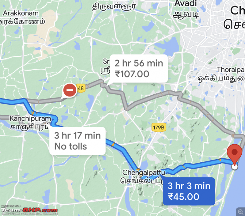
I have an upcoming trip from Bangalore to ECR (near Nemmeli) where I would be arriving late into the night (late afternoon start from Bangalore)

From Ranipet Google maps shows two routes
Sunguvarchatram - VIT - Kovalam toll - ECR
Walajabad - Chengalpattu - Thiruporur - ECR
Bangalore - Chennai - Bangalore : Route Queries-screenshot_20230223104001.png

There is not much to differentiate in time and distance between the two but I would like some suggestions from the surface, traffic and ease of driving late into the night.
GeeTee TSI is offline  
Old 23rd February 2023, 13:26   #4110
BHPian
 
Join Date: Sep 2013
Location: Bangalore
Posts: 32
Thanked: 39 Times
Re: Bangalore - Chennai - Bangalore : Route Queries

Quote:
Originally Posted by ravib View Post
1) Sriperumbudur to Kundrathur road, for first 300 meters are so is always just okay/slightly bad, but nothing concerning. Beyond that, just couple of/very few pot holes have popped in here and there post monsoon, but nothing major to complain to state the road condition is deteriorated badly. ITs 99% good roads for sure. Just be watchful to avoid the potholes and if we always keep the speed in control, below 100 kmph , it is manageable and also helps to avoid any stray cattle menace too.

2) There is no official U turn in NH at Rajiv Gandhi memorial (old Indira Gandhi statue location, which is now removed temporarily). One has to take left towards Sriperumbudur town and go for about 200 meteres and take a U turn back towards NH and then take right. That said, at night many people just take the right U turn in NH itself including trucks, when there is no police to catch

To join in ORR, you can definitely take Sriperumbudur-Madha college and take the exit towards Pattabiram. Its 100% more peaceful than going towards Sriperumbudur Toll mess and further driving towards Poonamallee. Highly recommended for sure.

-Ravi
I have a scheduled visit to Chennai coming up. My destination is near Sathyhttps://www.team-bhp.com/forum/images/smilies/Cheering.gifa Studios, Anna Sathya Nagar, Raja Annamalaipuram, Chennai-28.

I am not familiar with the routes in Chennai. Earlier on, I have been to Tambaram via Sriperumpudur - Mudichur and also via Sriperumpudur - Chennai ORR. Used GMaps on both ocassions.

As suggested by GMaps, I took the U turn on the Highway to enter Sriperumpudur, though there is no official U turn and many truck too did the same.

I have two questions :

1. GMaps suggests taking the Sriperumpudur - Kundrathur - ORR route. The other options is continue on the NH48 route. Please advise on the best route based on your experience.

2. I do not want to violate rules taking that U turn. Your suggested second point about the U turn towards sriperumpudur. Can you please elaborate on the exit towards Sriperumpudur from NH48.

Where exactly is the left turn towards Sriperumpudur ? Is it before this NH48 U turn or after that ? Any land marks.

Thanks in advance. Cheers
Aerobat is offline  
Reply

Most Viewed


Copyright ©2000 - 2024, Team-BHP.com
Proudly powered by E2E Networks