News
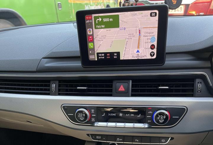
Is it worth spending Rs 9,000 to get BMW Maps on my X5 updated

Currently, I am using Google Maps on my smartphone but it would have been great to have a useable built-in navigation in the SUV.
BHPian vivekiyer20 recently shared this with other enthusiasts.
I recently purchased a pre-owned BMW X5 (F15, 3rd gen). The built-in navigation in it is really outdated and hardly useful. It obviously doesn't have CarPlay. While currently I am making do using Google Maps on my mobile, it would have been great to have a usable in-built navigation. The current navigation system is a 2013 version and doesn't recognize any of the locations inputted.
On speaking to the BMW service advisor, he said it could be updated for a price of 9K INR. I'm wondering whether it is worth it. Does anybody have any ideas/tips regarding this?
PS: I am in Mumbai, if it helps.
Here's what GTO had to say about the matter:
Not at all and IMHO, that applies to all "inbuilt" navigation systems by car manufacturers. Google Maps is the best and offers up-to-date information, routes & traffic data. My smartphone fits perfectly in the cupholder with the screen facing me. If that's not the case with you, either rely on audio instructions or get a smartphone holder.
Here's what BHPian ssjr0498 had to say about the matter:
It's not worth it! If you plan on keeping the car, the local accessories dealer could help you with a retrofit MMI box basis your current I-drive model.
Here's what BHPian kdp had to say about the matter:
The BMW maps are not terrible, especially if they are up to date. There are times that I prefer BMW maps to Google maps. For Example, in Bangalore, as a non-local, I have been guided down increasingly narrow "Main" roads; while relying on Gmaps. BMW maps, for the same run on a subsequent day, on the other hand, kept me on the real main roads. (longer, but ultimately about the same travel time. And yes, Gmaps is set to minimise travel time). You do lose traffic information, but an integrated map has a nice interface and it's useful to see directions on the HUD.
It does not need to cost an arm and a leg to keep BMW maps up to date. it can even be free. I am assuming that you have a CIC Head unit if it's a 2013 map. I had NBT on my F25. DM me if you need guidance on how to go about it.
Check out BHPian comments for more insights and information.
News
Google Maps error leaves German tourists lost and stranded in Australia
Google has since acknowledged the mishap and confirmed that the road in question has been removed from Google Maps.
According to reports, two German tourists, Philipp Maier and Marcel Schione, were stranded in Australia's wilderness after Google Maps led them astray with a faulty route.
The two tourists embarked on what should have been a straightforward drive to the small town of Bamaga in Queensland's northern region. However, Google Maps led them on a different route via a remote dirt road, which turned out to be the entrance to Oyala Thumotang National Park - which has been closed to the public since December 2023. What's worse is that their vehicle sank into the wet mud, leaving them stranded and lost with no cell service or way out.
Reports state that the two tourists camped inside their car for almost a week, even trying to build a tent, before deciding to attempt an escape on foot.
A spokesperson from Google has since acknowledged the mishap and confirmed that the road in question has been removed from Google Maps. The spokesperson also stated, "We apologise for this incident and are relieved that Philipp and Marcel are safe. We can confirm that this path has been removed from the map."
Source: TOI
- Tags:
- Indian
- Google Maps
- International
News
Google Maps to display 'personalised landmarks' to aid navigation
Google Maps will also include these locations in the turn-by-turn guidance.
Google Maps could soon be getting another update, as per a recent patent.
The recent patent filed by the company suggests that Google Maps could soon "display personalised landmarks" in its application. The new feature will monitor user's locations to create a list of regularly visited places. These locations will be considered personalised landmarks and will be highlighted on the Maps application when searching for directions. Reports suggest these locations could include homes, offices, coffee shops and regularly visited restaurants. Users will also be able to add their own favourite locations and organise them in lists.
The tech company also states that once the personalised landmarks are determined, the Maps application will use them to make navigation more straightforward. Google Maps will also include these locations in the turn-by-turn guidance when passing through a known location, making it easy for the app to guide you to your destination. Google believes the update could make navigation more intuitive.
However, as with any patent, the feature is still in its nascent stages, and it is yet to be confirmed if Google would actually introduce it onto devices.
Source: AutoEvolution
News
Google Maps starts rolling out improved UI on Android Auto

Android Auto users should slowly start receiving the update as the company completes the testing phase.
Tech giant, Google, has reportedly started rolling out an improved UI for its 'Google Maps' app, when running on Android Auto.
As per reports, the updated Google Maps comes with a significant UI update, giving it an almost fresh look. The app is said to have plenty of visual refinements which give it a cleaner and more modern look when running on Android Auto. Some of these new updates include new iconology on the floating bottom panel, better highlighting of essential information such as time to destination, easy access to settings & alerts and a newly designed zoom-in and out button on the lower left corner.
Apart from the visual refinements, Google has slowly been adding a number of new features recently. These include "eco-friendly routes" which now consider more factors when calculating the best route for a destination. This includes increased focus on fuel consumption, road incline and traffic conditions. Google claims that this feature helped reduce emissions by the equivalent of taking half a million cars off the road.
Google Maps also recently introduced "Immersive view" for a number of locations. This feature provides a multi-dimensional view of locations to help drivers get familiar with the areas before they even begin driving.
While Google has remained mostly tight-lipped about the redesign of the Maps on Android Auto, users should slowly start receiving the update as the company completes the testing phase.
Source: AutoEvolution
News
Google updates Maps with AI-powered features

EV owners can also check charging station information, such as car compatibility and when the charger was last used.
Google has announced the addition of a number of new immersive features on its Google Maps app, expected to be rolled out soon.
As per reports, Google will make use of Artificial Intelligence (AI) to offer the "Immersive View for Routes" feature, which offers better visualisation, including buildings and foliage. Google will use AI to combine its Street View with aerial images to help users visualise their destination, before actually going there.
Google has also integrated its "Lens" into Maps, which helps Google Maps orient itself using the phone's camera. The feature uses the phone's camera via Maps & with the help of AI and augmented reality, positions itself correctly, even if the GPS signal is lost. Further, the integration of Google Lens also shows users information about nearby ATMs, Cafes, Restaurants and more.
Other AI-powered features on Google Maps include detailed imagery with realistic-looking buildings, improved highway lane details, especially near exits and AI-powered speed limit information. EV owners can also check charging station information, such as car compatibility and when the charger was last used.
Source: CNET
- Tags:
- Indian
- Google Maps
- International
News
Google Maps stops showing petrol stations to EV owners

EV drivers will be able to access these features when connected to Android Auto or via the car's built-in Google systems.
According to a media report, Google recently rolled out an update beneficial for EV owners.
As per the report, EV drivers using Android Auto or Google's integrated operating system will stop seeing petrol stations as points of interest on their Google Maps. Instead, EV drivers will be shown charging stations and other information relevant when driving an EV.
Pearl Xu, Google's spokesperson, stated that some of the features have been available since 2022. He went on to outline some of the EV-specific features available in Google Maps. These features include charging speed filters, real-time charging port availability, a filter to find plug-type chargers, charging stations in search results and even adding charging stops during trips.
EV drivers will be able to access these features when connected to Android Auto or via the car's built-in Google systems.
Source: TheVerge
News
Built-in Google Maps to receive more EV-specific features

EV owners who use Google Maps on mobile devices or via Android Auto and Apple CarPlay will miss out on these features.
Google is all set to bring in a major update for electric vehicles with built-in Google Maps. According to reports, the new update will add a number of new features and offer users an almost seamless experience when driving around in an EV.
The new features include adding charging stops even for shorter trips, where the Maps will suggest the best stop based on factors like the vehicle's charge, energy consumption and current traffic. Google Maps has also introduced a new "very fast" filter which helps users search for 150 kW or faster charging stations. The update will also notify users if a specific place, like supermarkets or malls, provides on-site charging stations.
However, the new update is available only on electric vehicles which use in-built Google Maps. These include models from Polestar, Volvo, Renault, Honda and certain vehicles from General Motors' lineup. The update will be rolled out globally in the coming months.
EV owners who use Google Maps on mobile devices or via Android Auto and Apple CarPlay will miss out on these features.
The update is the latest by Google since it began rolling out EV-specific features in 2021. Previously, the tech giant introduced 'eco-friendly route' planning, which was more efficient than the shortest travel time option.
Source: Electrek
News
Google Maps now displays speed limits in India

Google has also partnered with Bangalore traffic police to optimize traffic light timings.
Last month, Google Maps announced the introduction of Street View in India. Google has also rolled out the speed limits feature in select cities.
Google Maps will show speed limit information in Bangalore and Chandigarh. The company is looking to introduce this feature in more cities by working closely with the local traffic authorities.
Google has also partnered with Bangalore traffic police to optimize traffic light timings. The company claims to have observed a 20% reduction in congestion across all intersections in the city and is now looking to run a pilot project in Kolkata and Hyderabad in the coming months.
Google will be working closely with local authorities to provide information on road closures and incidents across eight cities in India. These include Delhi, Hyderabad, Chandigarh, Ahmedabad, Kolkata, Gurgaon, Bangalore, and Agra.
Source: DNA
- Tags:
- Indian
- Google Maps
News
Google Street View now available in India

Google Street View will be available in 50 cities by the end of 2022.
Google is set to launch the Street View feature in India. This service, which is part of Google Maps, will be first introduced in 10 cities.
At present, Google Street View is available in Bangalore as part of a pilot project. Soon, the feature will be available in Hyderabad and Kolkata. Later, Google will add Chennai, Delhi, Mumbai, Pune, Nasik, Vadodara, Ahmednagar and Amritsar.
Google Street View was banned by the government of India citing security concerns. However, under the new National Geospatial Policy, 2021, local companies can collect such data and license it out to foreign companies, paving the way for Google to introduce the feature in India. This time, the company has partnered with Genesys International and Tech Mahindra.
In the initial phase, Street View will cover 1.50 lakh km across 10 cities. By the end of this year, the company plans to expand the service to 50 cities, covering almost 10 lakh km.
Google Street View offers high-definition 360-degree views of streets, tourist spots, etc. It uses panoramic and street-level 3D imagery.
- Tags:
- Indian
- Google Maps
- Street View
News
Google Maps testing Hybrid & EV-specific navigation function

There is no exact date when the powertrain-specific navigation feature might roll out.
According to a media report, Google Maps could soon incorporate vehicle powertrain considerations into route planning. While details are scarce, reports state that users will soon be able to select between petrol, diesel, hybrid & EV powertrain options, which will then be used to tailor the directions in order to save the most fuel or energy.
The new Google Maps feature is said to be in its beta phase, with testers receiving tailor-made route options for the most efficient drive based on the engine type selected. Reports, however, do not mention how Google will do this, but the update is said to offer different route alternatives when driving a hybrid (more efficient at low speeds), compared to a petrol or diesel-powered vehicle.
Reports also indicate that Google Maps could highlight routes with multiple charging stations along the way for electric vehicles.
There is no exact date when the powertrain-specific navigation feature might roll out. However, a traditional release might take place in the coming weeks.
Source: 9to5Google
- Tags:
- Indian
- Google Maps
- International
Pages
About Us