News
Google Maps to alert if cab drivers deviate from route

Google Maps has rolled out a new safety feature called 'Stay Safer' in India. The new feature alerts users travelling by public vehicles like taxis or auto rickshaws if their drivers deviate more than 0.5 km from the suggested route on Google Maps.
The Stay Safer feature is available for Android users. According to a media report, the app sends a notification on the phone when the driver deviates from the route. The user can tap on it to see where they are compared to the original route.
To activate the feature, users will have to select the 'Get off-route alerts' option under 'Stay Safer' after getting the destination. The 'Stay Safer' feature is only available in India at the moment.
Source: Economic Times
- Tags:
- Indian
- Google Maps
News
Google Maps gets live train tracking, bus travel estimates

Google has introduced three new features to Google Maps in India. These include live train tracking, bus travel estimates and mixed-mode directions results.
The live train tracking feature allows users to track the location of various trains in real time. It is especially useful for commuters who want to know at what time their train is expected to arrive at a specific station. Users can also view the list of trains operating between two locations.
The bus travel estimate feature gives an estimate of the time required to reach a certain destination by bus, based on live traffic conditions. This feature has been introduced in Delhi, Bangalore, Mumbai, Hyderabad, Pune, Lucknow, Chennai, Mysore, Coimbatore and Surat.
The mixed-mode directions results feature shows the total time required to complete a journey using multiple transport options. These may include, walking or trains, buses, rickshaws, etc.
Source: India Today
- Tags:
- Indian
- Google Maps
News
Google Maps starts marking speed cameras in India

Since last month, Google has started rolling out speed limit and speed camera information on Google Maps. The features were reportedly introduced in the UK, US, Australia, Russia, Brazil, Mexico, Canada and Indonesia initially. User reports suggest that the speed camera feature is now available in India as well.
The updated Google Maps app now has an option for users to report a speed camera. Once reported, an icon appears on the map, which is visible to those following the same route. The speed camera notification is shown in blue with the number of people who reported it. The feature is designed to warn commuters of speed cameras along the route and could be used to dodge traffic fines.
The speed camera features is currently not available on iOS devices but could be rolled out soon.
Users can also report an accident, which is then displayed in red along with time required to cross that section of road.
News
Apple CarPlay will now support 3rd party maps

The next version of the Apple's mobile operating system - iOS 12, will support 3rd-party navigation apps like Google Maps and Waze. The announcement came at the annual Apple Worldwide Developers Conference (WWDC) held from June 4 - June 8 this year.
Apple CarPlay allows the car's infotainment system / head unit to act as a display and controls the connected iPhone using the existing buttons in the car. Software is run on the phone and CarPlay uses only the display and hardware interface of the car's system. At present, CarPlay supports only Apple Maps. However, navigation via Apple Maps is not available in many places including India. On the other hand, rival Android Auto supports Google Maps, which is considered as one of the better navigation systems.
CarPlay is available on all iPhone 5 and later models with at least iOS 7.1.
The CarPlay system was rolled out in 2014, with an aim to provide safer interactions with a mobile device when driving. Users can control CarPlay from the car’s native interface or just push-and-hold the voice control button on the steering wheel to activate Siri without distraction. In India, manufacturers including Ford, Maruti, Mercedes, Hyundai, and others provide Apple CarPlay compatible infotainment systems in their cars.
- Tags:
- Indian
- Apple
- Apple CarPlay
- Google Maps
News
MapmyIndia launches Map app for Android and IOS


MapmyIndia has launched a navigation app for mobile devices. The app can be downloaded free of cost on Android and IOS platforms. It has built-in navigation, tracking and analytics features. The app uses maps created using images from ISRO's Bhuvan geo-portal. Bhuvan provides with 1 m resolution satellite data for more than 350 cities in India and 2.5 m resolution for other areas.
Once downloaded, the app prompts users to sign-up or login via Facebook. To find a location, the app uses eLoc - MapmyIndia's nationwide digital address system that gives a 6 character digital address to every location. To search an address, users can enter the digital address in the search bar. The app has features like voice-guided directions, traffic information, estimated time of arrival, life traffic updates among others.
Users can also share their location through the app. The secure live location feature updates your location continuously for a set duration. After that the link expires. Besides this, the app can also be used as a mobile tracking device.
World View is a feature where users can share information about a particular locality. It is a live feed of ratings, reviews, check-ins and insider tips for tourists. The app highlights nearby places of interest like metro stations, public toilets, parking spots and petrol pumps as well.
The app stores a detailed timeline of where the user has been. This feature is particularly useful cyclists or runners who would want keep track of the route, distance and duration. Users can also share their route with others. Finally, users can report issues regarding the map, traffic and civic issues to concerned authorities using the app.
- Tags:
- Indian
- MapmyIndia
- Google Maps
News
Google Maps launches 2-wheeler mode in India
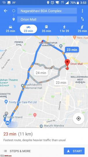
At the third annual ‘Google for India’ event in Delhi, the company rolled out 2-wheeler mode for Google Maps in India.
In the latest version of the Google Maps app, the 2-wheeler mode displays shortcuts that aren't accessible to cars and larger vehicles. While planning the route, a rider can view major local landmarks on the way which will be useful during navigation. This way, the rider wouldn’t have to check the phone frequently while riding. Voice-guided navigation like the car mode has also been carried forward to the 2-wheeler mode.
India is the first country to get the 2-wheeler mode where a large portion of the population uses bikes and scooters for their daily commute. The 2-wheeler mode for Google Maps will be available in other countries in the coming months.
News
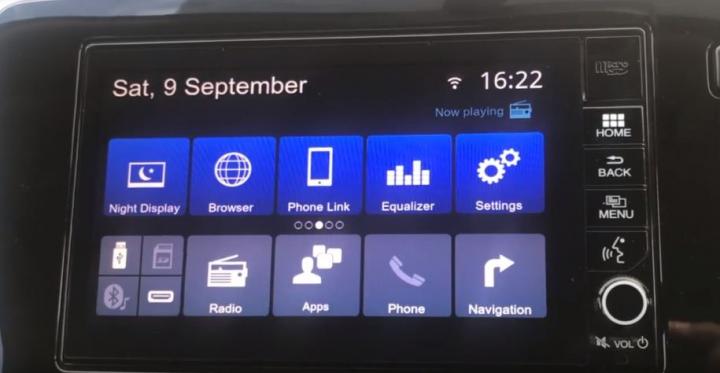
Installing Apps on an OEM Honda AVN infotainment system


Thanks to Prabhu Vairakkannu for sharing this information with other enthusiasts!
Touchscreen infotainment systems have become common in modern cars. But, some of the recent OEM systems have been less intuitive or lacking features. The AVN infotainment unit offered in the 2017 Honda City is one such example. It could have been better. The latest iteration of the system comes with MirrorLink and turn by turn navigation but misses out on Android Auto or Apple CarPlay.
Now, the system itself was compatible with Android Auto and Apple CarPlay, but Honda decided to skip these features. That fact that the system is compatible with the said apps means these could be included in a future software update. For now, here are a few handy tricks to unlock the full potential of Honda's AVN system. These are not hacks that will void the warranty of the device. All you need to do is access the administration menu (which is hidden by default).
Once you have full control of the device, you will be able to install new software just like you'd install apps on your smartphone.
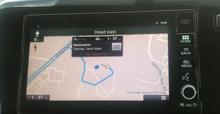
The following DIY video shows you how to install Google Maps on the infotainment system of a Honda City or WR-V: watch video
The OEM infotainment system can also play videos while the car is in motion. Here is a video showing you how to access this feature: watch video
News
Google Maps offline now in India!


Link to Team-BHP's Google Maps discussion
In a move that will find many of us with unreliable internet connections rejoicing, Google Maps offline has now been launched in India. You can now download the map of an area for offline access to your phone, and even if your internet connections fails, Google Maps will continue to work. The offline functions include turn-by-turn navigation and searching for specific destinations.
As an example, if you are on your way to Bangalore and aren't sure how well your service provider will perform there, you can download the maps of Bangalore in Google Maps by searching for “Bangalore”, and then tapping "download" or by going to "offline areas" in the Google Maps menu and tapping the “+” button to add a location.
It is important to note that Google Maps will only download areas to your device when you are on a Wi-Fi connection. Once you’ve downloaded your map, Google Maps will work even when you’re somewhere with inconsistent or no connectivity at all. When a connection is found, it will switch back to online mode, so you can access the full version of Maps, including live traffic conditions for your current route. The feature will make its way to Google Maps on iOS as well.
News
Google's Android for the Automobile Industry
Last night, Google announced its plans to expand Android into the automobile industry. The tech is called 'Android Auto'. It boasts of a complete voice enabled interface which links your android smartphone to the car. The setup uses the phone to run all the apps, while the car's entertainment screen acts as the display. This has the unique advantage of allowing 'Android Auto' to be updated easily and frequently (whenever the phone receives updates).
This system focuses on 3 important aspects that a person is concerned with while driving a vehicle - navigation, communication and music.
A user may engage navigation by voice command, which will run Google maps. Similarly, Android Auto reads text messages aloud and allows you to reply to these messages by voice too. You can even tell it to play music from your smartphone. All this without lifting your hands off the steering wheel!
Already, 40 auto companies have joined hands with Google for this technology including Audi, Honda, Hyundai, Chevrolet, Ford and Fiat to name a few. The first production vehicle running Android Auto is expected to make its debut by the end of 2014.
Apple too has developed a similar technology for its iPhone users, called CarPlay, which will be a direct rival to Google's Android Auto. This kind of connectivity for smartphones has certainly taken the phrase 'eyes on the road, hands on the wheel' to a new level.
- Tags:
- Indian
- Google Maps
News
Indian automotive shops, now on Google Indoor Maps


Thanks to BHPian Warwithwheels for bringing this to our notice.
Google Maps has recently started a new feature called Indoor Maps in India, which gives users access to floor plans of various places that are participating. These places include shopping malls, museums and other establishments. Certain automotive shops are also listed.
Indoor Maps can be accessed using a computer or a smartphone. On Android phones, it requires the latest version of Maps to be installed.
Indoor Maps provides a 360 degree view of the inside of the organisation. Users can get an idea of the layout of the shop, the range of products it deals in and the brands that it stocks. Using the zoom function, one can get a close look at a particular product that he is interested in. The details appear good enough to make the model number and description of some of the products legible.
Additionally, one can check out the ease of parking, the service bays available and the ease of access for aged or disabled people at the organisation.
Pages
- « first
- ‹ previous
- 1
- 2
- 3
About Us