Team-BHP > Shifting gears > Gadgets, Computers & Software
Register New Topics New Posts Top Thanked Team-BHP FAQ


Reply
  Search this Thread
83,686 views
Old 15th June 2013, 09:51   #121
BHPian
 
esma1981's Avatar
 
Join Date: Jun 2013
Location: Mumbai
Posts: 108
Thanked: 209 Times

Quote:
Originally Posted by amalji View Post
I always find my GPS on galaxy Note faster in connection than the dedicated GPS of MapmyIndia.
That should almost always be the case as all mobile phones have Assisted GPS which leads to faster "time to first fix" whereas majority of basic dedicated GPS devices do not have sim slots.

Last edited by esma1981 : 15th June 2013 at 10:00.
esma1981 is offline  
Old 15th June 2013, 22:50   #122
Senior - BHPian
 
DerAlte's Avatar
 
Join Date: Mar 2007
Location: Bangalore
Posts: 8,069
Thanked: 2,919 Times

Quote:
Originally Posted by amalji View Post
... Not the case when bridges are closed. You might end up traveling 3-4 km extra with offline gps
Usually when a bridge is closed on a highway, the deviation is 30-40km, not 3-4km. And the deviation will be the same whether it is Google Maps or a stored-maps GPS. Knowing the bridge is closed beforehand is not going to help reduce that distance, whether 5 min. earlier or at all.

Quote:
Originally Posted by esma1981 View Post
... faster "time to first fix" ...
Knowing the behaviour of my Garmin unit when I land in place I have never been to or have gone after quite sometime (usually by flight), I switch it on long before I get into the car. That is because I anticipate a 'fix' time of a few minutes. If I am switching it on in a place where the GPS last got fix, it takes 1-2 minutes even if I switch it on after a couple months. Usually in my travel planning, I would already have searched, located and stored where (all) I have to go, so that doesn't take any more time.

So, why and how would it matter how long it takes to get a fix? Would I arrive that much earlier? Might I not be most likely delayed more than that due to other real world reasons?
DerAlte is offline  
Old 15th June 2013, 22:59   #123
Senior - BHPian
 
Join Date: Apr 2008
Location: Dombivli
Posts: 3,056
Thanked: 2,139 Times

Quote:
Originally Posted by DerAlte View Post
So, why and how would it matter how long it takes to get a fix? Would I arrive that much earlier? Might I not be most likely delayed more than that due to other real world reasons?
It does matter for a person like me who thinks he knows all, but is actually poor in making real time course corrections. On a few occasions it really was helpful to get a quick fix onto the sat.

Of course as you have said, better preparation usually beats almost all problems.
honeybee is offline  
Old 16th June 2013, 00:49   #124
BHPian
 
esma1981's Avatar
 
Join Date: Jun 2013
Location: Mumbai
Posts: 108
Thanked: 209 Times

Quote:
Originally Posted by DerAlte View Post
I switch it on long before I get into the car. That is because I anticipate a 'fix' time of a few minutes
I was merely stating advancement in technology, so you do not have to do that. Of course, it's not a must have feature that all GPS devices should come with. But it doesn't hurt
esma1981 is offline  
Old 16th June 2013, 01:47   #125
Senior - BHPian
 
amalji's Avatar
 
Join Date: Sep 2009
Location: Bengaluru
Posts: 1,644
Thanked: 3,178 Times

Quote:
Originally Posted by DerAlte View Post
Usually when a bridge is closed on a highway, the deviation is 30-40km, not 3-4km. And the deviation will be the same whether it is Google Maps or a stored-maps GPS. Knowing the bridge is closed beforehand is not going to help reduce that distance, whether 5 min. earlier or at all.
1. I never mentioned highway. And no, it doesn't necessarily mean 30 km. I've seen multiple such instances where i had to travel 3-4 km extra.
2. With online GPS like Google maps, you would be on an alternate route which would have saved you at least half the distance.

PS: I'm someone who have used offline GPS for 2 years. Google maps is leagues ahead now. I don't see any reason why i should be using my offline GPS now. Even if I've zero connectivity, i can still depend on navfree free offline GPS on Android. Having said that, the number of times i had to depend on offline GPS due to lack of connectivity in the last one year is zero.
amalji is offline  
Old 16th June 2013, 10:37   #126
Team-BHP Support
 
Samurai's Avatar
 
Join Date: Jan 2005
Location: Bangalore/Udupi
Posts: 25,832
Thanked: 45,618 Times
Re: Google Maps making MapMyIndia (and similar products) obsolete?

Quote:
Originally Posted by amalji View Post
Having said that, the number of times i had to depend on offline GPS due to lack of connectivity in the last one year is zero.
You should get out more.

I regularly drive through areas that have no data coverage, if not mobile coverage. So I entirely depend on offline GPS.
Samurai is offline  
Old 16th June 2013, 10:50   #127
Senior - BHPian
 
amalji's Avatar
 
Join Date: Sep 2009
Location: Bengaluru
Posts: 1,644
Thanked: 3,178 Times

Quote:
Originally Posted by Samurai View Post
You should get out more.

I regularly drive through areas that have no data coverage, if not mobile coverage. So I entirely depend on offline GPS.
Almost all of kerala's forest is covered by BSNL or idea. Moreover, Google maps doesn't need consistent data connection. It intelligently caches the maps, when data connection is available.
Forget all of that. If you are going to be in some remote location for a week, you have the option to download whole of that map in Google ( for offline navigation ). For eg:- I've the whole of ernakulam district, some parts of Thrissur and idukki available offline on Google maps because I travel very frequently in these areas. So, there is a solution for everything on Google maps. Add to that, the unmatched nook and corner coverage of Google. Many small rural roads which are non existent on offline navigation systems like MapmyIndia. I understand that because I'm someone who do get out a lot. ;-)
amalji is offline  
Old 16th June 2013, 11:58   #128
Senior - BHPian
 
DerAlte's Avatar
 
Join Date: Mar 2007
Location: Bangalore
Posts: 8,069
Thanked: 2,919 Times

Quote:
Originally Posted by amalji View Post
... So, there is a solution for everything on Google maps. ...
Nice! You will accept the faults and be happy with workarounds with Google Maps, yet find it difficult to accept the same with stored-maps nav units.

By 'bridges' you must have meant the 10m 'culverts' over 'canals' in Kerala? Only those need a 3-4Km diversion. Bridges over rivers (usually 300m or longer) cause a much longer deviation, since one will need to take another state highway to take another bridge to get back to wherever one is going.

Also, if you *need* to go to a place, you will not go there if it doesn't appear on Google Maps or Garmin/MMI/Tomtom units? LOL that is a rather strange dependence!!! As someone mentioned earlier, P-GPS is usually the default method anyhow in such cases.
DerAlte is offline  
Old 16th June 2013, 12:29   #129
Senior - BHPian
 
amalji's Avatar
 
Join Date: Sep 2009
Location: Bengaluru
Posts: 1,644
Thanked: 3,178 Times
Re: Google Maps making MapMyIndia (and similar products) obsolete?

Quote:
Originally Posted by DerAlte View Post
Nice! You will accept the faults and be happy with workarounds with Google Maps, yet find it difficult to accept the same with stored-maps nav units.
I'm happy, if there is a work around for my problems in offline GPS. But, unfortunately, there is no way out. for eg:-

1) Some roads are entirely missing in an offline GPS setup. I've done multiple updates thinking that the road would come. But, unfortunately, it does not.

2) Even shops which change address or new shops which come up doesn't get updated on an offline map. With google maps, I'm confident that it will take me to a shop in Kochi 95 out of 100 queries I give it. With offline GPS, it's nearer to 50%.

There's simply NO work around for this flaw in an offline GPS. With google maps, there is a work around for everything. Correct me, if I'm wrong.

Quote:
Originally Posted by DerAlte View Post
By 'bridges' you must have meant the 10m 'culverts' over 'canals' in Kerala? Only those need a 3-4Km diversion. Bridges over rivers (usually 300m or longer) cause a much longer deviation, since one will need to take another state highway to take another bridge to get back to wherever one is going.
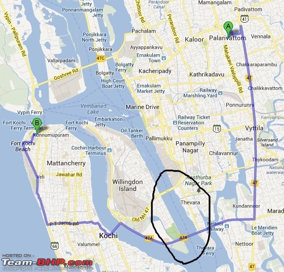
If I bluntly put it, your point is absolutely wrong. Check out the attachment.
Google Maps making MapMyIndia (and similar products) obsolete?-palarikochi_v2.jpg
1) We have many bridges in Kerala which are close to each other. Knowing that one bridge is closed before the journey starts has a lot of advantage because, it will plan your route much better ( a lot of time can be saved considering the kind of traffic congestion that we have in Kerala and Kochi especially ). The one shown in the pic is around 500 m long
2) Bridges do not need to be 300 m long. With the kind of revers in kerala, we have bridges ranging from 100 meters to a few kms long. These are all proper bridges and not 'curlverts' as you mentioned
3) In addition to this, add the over bridges as well. Even they can be closed for maintenance ( as we found out on one of our team-bhp meets in Kochi ). Had I used an online GPS then, I would have saved 30 minutes.

Quote:
Originally Posted by DerAlte View Post
Also, if you *need* to go to a place, you will not go there if it doesn't appear on Google Maps or Garmin/MMI/Tomtom units? LOL that is a rather strange dependence!!! As someone mentioned earlier, P-GPS is usually the default method anyhow in such cases.
I never mentioned this. This is putting words into my mouth. I'll go to a place irrespective of whether it appears in the maps or not. But, at the same time, I'm smart enough to chose a method which has more probability of finding the route for me and that's why I chose google maps over any other offline GPS system available right now ( especially in India ).

PS: Investment in an offline GPS system, I consider it a complete waste of money. Having done that myself, I don't have any problem in admitting that I made a blunder. If people still are particular about offline GPS ( that too paid version ) go buy the sygic offline navigation app from android. It's still better than the crappy offline GPS systems available right now in the market.

Last edited by amalji : 16th June 2013 at 12:43.
amalji is offline  
Old 16th June 2013, 12:51   #130
Team-BHP Support
 
Samurai's Avatar
 
Join Date: Jan 2005
Location: Bangalore/Udupi
Posts: 25,832
Thanked: 45,618 Times
Re: Google Maps making MapMyIndia (and similar products) obsolete?

Which offline GPS PND you use? I am unable to understand why you consider them so bad.
Samurai is offline  
Old 16th June 2013, 13:21   #131
Senior - BHPian
 
amalji's Avatar
 
Join Date: Sep 2009
Location: Bengaluru
Posts: 1,644
Thanked: 3,178 Times

Quote:
Originally Posted by Samurai View Post
Which offline GPS PND you use? I am unable to understand why you consider them so bad.
I've used both Delphi ( mapmyindia ) and Garmin ( with their latest maps ). I hate it for very simple reasons.

1) Many roads ( especially in rural Kerala ) are simply missing
2) Some remote place names are completely missing even though the roads are there.
3) Place names have typo errors making it impossible to search sometimes.
4) Always out dated - like having the map up-to-date especially in a place like Kerala where new over bridges and normal bridges are coming up very frequently.
5) You want to go to a shop in Kerala, you simply cannot depend on offline GPS, because half of those shops are simply not added to offline GPS system. You are on a city and you want to go to a 'not well known place' within that city, google maps is the way forward.
6) Lack of convenience. for eg:-, a friend invites me for his marriage with a route map from google. With google maps navigation, all I have to do is click on the link on that email. Rest is taken care of by the google navigation system. No searching, no validation etc. as is the case with offline navigation systems.

@ontheroad PMed me 2 questions. Since, I found the questions to be of relevance to many others, posting the reply on the forum.

Quote:
Originally Posted by ontheroad
Hi Amal,
It was regarding 2 doubts reg gmap.
1) Can we save a track in gmap? Any tricks for that? One bhpn recommended a shortcut track in gmap. To access that, i need to login to inbox, and click the gmap link. If i can save the track offline it would be better
2 ways to do it.

Option - 1 ( Save the hyper link )

1) Find the convenient route on maps.google.com
2) Click on "Link" button and copy the corresponding URL, send it to gmail or evernote ( Sending it to evernote has the added advantage of having it available offline for future reference even if you haven't configured your email on your phone )

This is the best method, since all you have to do is click on the link whenever you want to navigate. This is what I use.

A sample link pasted below -
https://maps.google.com/maps?saddr=k...ra=ls&t=m&z=10

Option - 2 ( save to my maps )

1) Find the convenient route on maps.google.com
2) On the left side of the maps, where the directions are listed, scroll down to the bottom, and click on "Save to My Maps"
3) On your android phone, open google maps, click on menu, and then on layers and then on "My Maps".
4) Click on the destination, on the map, and then click on navigate icon.

Quote:
Originally Posted by ontheroad
2) Can we draw a track as we wish in gmap. Ex If i select to go from tvm to allepy, gmap recommends nh47 route. But if i want the track through changanassry how to get it in one go?
Thanks in advance
1) First search for your destination on your android device. This will take you to the default route.
2) Click on Menu --> Routes and Alternates. Then click on the alternate route icon.

This will show you multiple routes which makes sense. You can chose from one among that. See the attachment for example. It shows 3 routes

a) Kakkanad - Vaikom - Kumarakom - Kottayam
b) Kakkanad - Cherthala - Kumarakom - Kottayam
c) Kakkanad - Ettumanoor - Kottayam

Attachment 1097689

Last edited by Samurai : 16th June 2013 at 17:10. Reason: as requested
amalji is offline  
Old 16th June 2013, 16:31   #132
BHPian
 
Join Date: May 2012
Location: UK-07
Posts: 482
Thanked: 1,157 Times
Re: Google Maps making MapMyIndia (and similar products) obsolete?

Quote:
Originally Posted by amalji View Post
Option - 2 ( save to my maps )

1) Find the convenient route on maps.google.com
2) On the left side of the maps, where the directions are listed, scroll down to the bottom, and click on "Save to My Maps"
3) On your android phone, open google maps, click on menu, and then on layers and then on "My Maps".
4) Click on the destination, on the map, and then click on navigate icon.
Of the second method I wanted to know whether it saves the map/route on the phone and let you access it offline, i.e. even when there is no data connection/GPRS connection combining just the saved layer/map/route and the phone's onboard GPS to navigate? Noob question, I know, but I'm not too familiar with the workings of Google maps & its navigation and it certainly wouldn't hurt to learn from an expert.

Cheers !!
Ironhide is offline  
Old 16th June 2013, 22:59   #133
BHPian
 
ontheroad's Avatar
 
Join Date: Dec 2006
Location: KL-01/KL-08
Posts: 326
Thanked: 176 Times

Quote:
Originally Posted by amalji View Post

I've used both Delphi ( mapmyindia ) and Garmin ( with their latest maps ). I hate it for very simple reasons.

1) Many roads ( especially in rural Kerala ) are simply missing
2) Some remote place names are completely missing even though the roads are there.
3) Place names have typo errors making it impossible to search sometimes.
4) Always out dated - like having the map up-to-date especially in a place like Kerala where new over bridges and normal bridges are coming up very frequently.
5) You want to go to a shop in Kerala, you simply cannot depend on offline GPS, because half of those shops are simply not added to offline GPS system. You are on a city and you want to go to a 'not well known place' within that city, google maps is the way forward.
6) Lack of convenience. for eg:-, a friend invites me for his marriage with a route map from google. With google maps navigation, all I

@ontheroad PMed me 2 questions. Since, I found the ......

Searched for the thanks button, but seems it is not available in this thread. Thanks amalji for the detailed reply

Last edited by ontheroad : 16th June 2013 at 23:00.
ontheroad is offline  
Old 17th June 2013, 14:41   #134
Senior - BHPian
 
DerAlte's Avatar
 
Join Date: Mar 2007
Location: Bangalore
Posts: 8,069
Thanked: 2,919 Times
Re: Google Maps making MapMyIndia (and similar products) obsolete?

Quote:
Originally Posted by amalji View Post
... There's simply NO work around for this flaw in an offline GPS. With google maps, there is a work around for everything. Correct me, if I'm wrong. ...
If our lives are woven around Google, you would be right. Fortunately, most of us are not that dependent. Most of us use Navigation as an aid, and our lives are not disabled by flaws or shortcomings of that. We can still reach our destinations if a new road or a shop is not listed.

Quote:
Originally Posted by amalji View Post
... If I bluntly put it, your point is absolutely wrong. Check out the attachment. ...
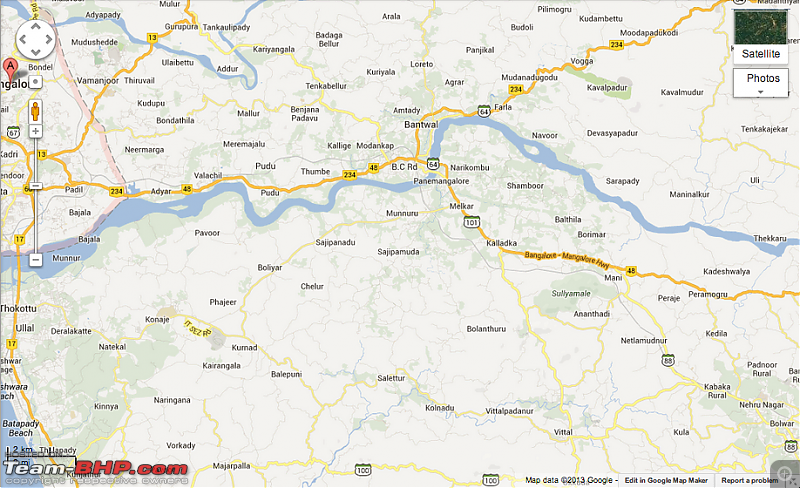
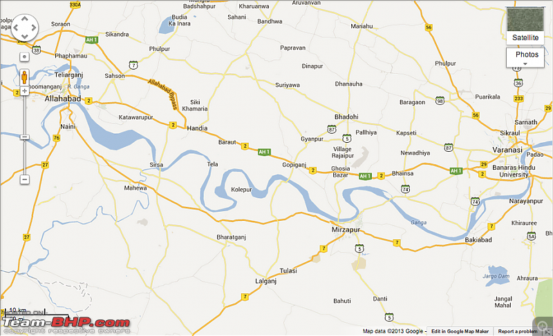
Oh you may, by all means! BUT ... please realize the difference in urban scenarios like Kochi (it IS a city, after all), and real highway situations one faces in India (or for that matter any country) - which is considerably larger than Kochi. See below - 2 very typical scenarios in India (go further east, it is even worse):
1. If the bridge near Panemangalore (on NH47) is closed, one can only cross near Uppinangady (off the map to the east) or travel a circuitous route to reach NH17 and cross near Thokottu. Please estimate the deviation distance
Google Maps making MapMyIndia (and similar products) obsolete?-screen-shot-20130617-1.59.21-pm.png

2. Please count how many bridge crossings are there over the Ganges between Allahabad and Varanasi (about 140Km apart). Now please imagine what happens when any of these bridges are closed
Google Maps making MapMyIndia (and similar products) obsolete?-screen-shot-20130617-2.04.53-pm.png

You will realize that even without a navigation aid, you will not be considerably delayed in Kochi, if you don't know the route. OTOH, in situations where there are few alternatives, one will be left between the devil and the deep sea in other parts of India. And Google's update frequency for those areas is same as, or worse than, stored-map devices - and that is where one needs navigation the most.

Quote:
Originally Posted by amalji View Post
... I'm smart enough to chose a method which has more probability of finding the route for me ...
That is what I described as 'strange dependence'!

Quote:
Originally Posted by amalji View Post
... the sygic offline navigation app from android. It's still better than the crappy offline GPS systems ...
Could you please elaborate what is so advantageous about Sygic? I have used Sygic since their WinCE version (2004... IIRC), and I couldn't find any disadvantages of using Garmin or Tomtom.
DerAlte is offline  
Old 17th June 2013, 15:01   #135
Team-BHP Support
 
ampere's Avatar
 
Join Date: Sep 2009
Location: Bangalore
Posts: 17,952
Thanked: 12,944 Times
Re: Google Maps making MapMyIndia (and similar products) obsolete?

Quote:
Originally Posted by DerAlte View Post
Could you please elaborate what is so advantageous about Sygic? I have used Sygic since their WinCE version (2004... IIRC), and I couldn't find any disadvantages of using Garmin or Tomtom.
My notes: There are two aspects:

- Use of paid map content like MMI other than Google
- Buying separate HW for navigation rather than phone.

On Hardware, I would be happy to buy a separate PND even in this day and age of integrated devices because, I simply dont want to subject high end phones to continuous use of GPS/3G. I see that they get heated quite a lot. I tried basic navigation in the city for half an hour while driving to office and when I reached, I could not touch the phone. You can call it personal preference. Meanwhile PNDs I think remain much cooler, as they are specifically designed for that purpose. They may not be as compact as phone. Hence heat dissipation is also better than a smart phone. The one that I purchased was 5 years back. It still serves me, but I have changed phone many a times.

Coming to use of map content, its good to have Google no doubt. But I would also not depend fully on it. Simply because my a times connections dont remain on. One can say a cached mode will work, but coupled with my previous point on HW usage, I would go with a PND. And also I like to track the whole of my drive. I surely dont want my phone to be subjected to such a use case. To find an actual route, I dont depend on any one map. Best is research all available Google, MMI etc etc and translate all that into the device which would help me guide (in this case my PND and not phone). The real use of Google and phone for me is a case where I am some city, need some thing quick to know where is what. Of course many use it for navigation too. But it does not work for me.

Last edited by ampere : 17th June 2013 at 15:06.
ampere is offline  
Reply

Most Viewed


Copyright ©2000 - 2024, Team-BHP.com
Proudly powered by E2E Networks