

 23rd February 2010, 09:21
| #76 |
| Senior - BHPian Join Date: Mar 2008 Location: B L R / T V M
Posts: 1,071
Thanked: 9 Times
| |

|


| |
|
23rd February 2010, 10:57
| #77 |
| Team-BHP Support  | |
|
|
|
23rd February 2010, 11:02
| #78 |
| BANNED Join Date: Apr 2008 Location: Bangalore
Posts: 11,797
Thanked: 27,252 Times
Infractions: 0/3 (13) | |
|
|
|
23rd February 2010, 11:15
| #79 |
| Team-BHP Support | |
|
|
|
23rd February 2010, 11:26
| #80 |
| Senior - BHPian | |
|
|
|
23rd February 2010, 11:26
| #81 |
| BHPian | |
|
|

|
23rd February 2010, 11:58
| #82 |
| BHPian Join Date: Feb 2008 Location: bangalore
Posts: 180
Thanked: 6 Times
| |
|
|
|
23rd February 2010, 12:33
| #83 |
| Team-BHP Support | |
|
|
|
23rd February 2010, 15:37
| #84 |
| Senior - BHPian | |
|
|
|
23rd February 2010, 15:50
| #85 |
| Team-BHP Support | |
|
|
|
23rd February 2010, 16:43
| #86 |
| Senior - BHPian | |
|
|
| |
|
23rd February 2010, 18:33
| #87 |
| Team-BHP Support | |
|
|
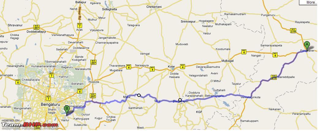
 . The roots looks good, but not sure of the road conditions. I have read on the forum about people coming from Kolar on the NH4 using the Malur route to bypass Bangalore (via Baglur/Hosur).
 |
24th February 2010, 00:12
| #88 |
| Senior - BHPian Join Date: Mar 2008 Location: B L R / T V M
Posts: 1,071
Thanked: 9 Times
| |
|
|

|
24th February 2010, 06:17
| #89 |
| Team-BHP Support | |
|
|
|
25th February 2010, 13:03
| #90 |
| BHPian | |
|
|
 |
Most Viewed