Team-BHP > Technical Stuff


Reply
  Search this Thread
322,919 views
Old 27th November 2008, 00:06   #646
Team-BHP Support
 
tsk1979's Avatar
 
Join Date: Feb 2005
Location: San Jose, CA
Posts: 23,695
Thanked: 23,484 Times

Oh ok,
Since there is no windows CE version, you need to have a windows mobile or Symbian PC.
tsk1979 is offline  
Old 27th November 2008, 13:33   #647
Senior - BHPian
 
gd1418's Avatar
 
Join Date: May 2006
Location: Gurgaon
Posts: 3,577
Thanked: 729 Times

Have you tried this - AERIAL SERVICES PVT. LTD. - Home..? AERIAL SERVICES PVT. LTD. - Garmin Products - Automobile - Nüvi 250w

I have been using the Garmin iQue 3600 since 2005, purchased from Delhi from the above dealer..

Quote:
Originally Posted by DerAlte View Post
Has anyone used a dedicated device like Garmin Nuvi 260W in India? Are there ready-made maps available for NCR / Bangalore / Mumbai for this device? I wanted to gift it to my sister, who is not tech savvy - hence it has to be a simple out of the box solution for her.

Last edited by gd1418 : 27th November 2008 at 13:40.
gd1418 is offline  
Old 3rd December 2008, 10:04   #648
BHPian
 
prsnck's Avatar
 
Join Date: Jul 2008
Location: Bangalore
Posts: 196
Thanked: 81 Times

guys..

I too hold a nokia navigator 6110 - i too agree the same -

Found it as a good navigation phone. But the issue here is, the national / state highways are not covered in the built-in maps.

Does any one have idea where can we download the maps for national / state highways in India - me being frequent traveller within south and plans to extend to north of India too - my actual purpose was this only behind buying Nokia 6110.

Please provide the exact URL and do we need to download the appropriate software.

some more info :

I could locate the iNav Loaded WF from mapmyindia.

Is this one we are talking about to get all the Highways (NH and SH), all cities and roads connected in India. Please guide me.

http://inav. mapmyindia. com/product/ iNavLoadedWF/ buy_inavLoadedWF .html

Appreciate reply from folks.

Rgrds
prsn
prsnck is offline  
Old 3rd December 2008, 11:42   #649
Senior - BHPian
 
harjeev's Avatar
 
Join Date: May 2006
Location: New Delhi
Posts: 1,900
Thanked: 296 Times

Quote:
Originally Posted by prsnck View Post
guys..

I too hold a nokia navigator 6110 - i too agree the same -

Found it as a good navigation phone. But the issue here is, the national / state highways are not covered in the built-in maps.

Does any one have idea where can we download the maps for national / state highways in India - me being frequent traveller within south and plans to extend to north of India too - my actual purpose was this only behind buying Nokia 6110.

Please provide the exact URL and do we need to download the appropriate software.

some more info :

I could locate the iNav Loaded WF from mapmyindia.

Is this one we are talking about to get all the Highways (NH and SH), all cities and roads connected in India. Please guide me.

http://inav. mapmyindia. com/product/ iNavLoadedWF/ buy_inavLoadedWF .html

Appreciate reply from folks.

Rgrds
prsn
Search this forum for MGMAPS

Also try Mobile GMaps - View maps from various sources on your mobile phone!

I am using this in my Nokia E90. This dosent have turn-by-turn navigation, But if maps are the only thing that you are looking for, Then I think that this is the best.
harjeev is offline  
Old 3rd December 2008, 12:17   #650
Senior - BHPian
 
Sudipto-S-Team's Avatar
 
Join Date: Jun 2007
Location: Kolkata
Posts: 1,319
Thanked: 292 Times

Quote:
Originally Posted by gd1418 View Post
Have you tried this - AERIAL SERVICES PVT. LTD. - Home..? AERIAL SERVICES PVT. LTD. - Garmin Products - Automobile - Nüvi 250w

I have been using the Garmin iQue 3600 since 2005, purchased from Delhi from the above dealer..
Interesting to find another Garmin user here. What Indian maps do you use? Do you use any map at all or just create your own way points? Are Garmins capable of using any map other than those made by Mapsource? I have a very basic Foretrex because when I bought GPS at that time no digital map was available for loading.
Sudipto-S-Team is offline  
Old 3rd December 2008, 12:23   #651
Team-BHP Support
 
tsk1979's Avatar
 
Join Date: Feb 2005
Location: San Jose, CA
Posts: 23,695
Thanked: 23,484 Times

You can use any img map.
openstreetmap(or rather cloudmade) offer india.img which is updated every week.
tsk1979 is offline  
Old 3rd December 2008, 12:49   #652
Senior - BHPian
 
jkdas's Avatar
 
Join Date: Sep 2005
Location: Thiruvananthapu
Posts: 9,687
Thanked: 1,496 Times

Did anyone report this here ?
Nokia Buys Navteq For $8 Billion, Bets Big On Location-Based ...
jkdas is offline  
Old 3rd December 2008, 13:41   #653
BHPian
 
prsnck's Avatar
 
Join Date: Jul 2008
Location: Bangalore
Posts: 196
Thanked: 81 Times
hi harjeev

Quote:
Originally Posted by harjeev View Post
Search this forum for MGMAPS

Also try Mobile GMaps - View maps from various sources on your mobile phone!

I am using this in my Nokia E90. This dosent have turn-by-turn navigation, But if maps are the only thing that you are looking for, Then I think that this is the best.

-----------------------------------

Hi,

I just had browse thru of - Mobile GMaps - Download

which version should we select -

1. Stable
2. Development
3.Older stable

Also this works online I hope. I mean, could we have offline maps, which works without being connected to net.

consider I do not have access to Internet or WAP, how should I proceed. Are there work arounds or some other sites.

rgrds
prsn
prsnck is offline  
Old 3rd December 2008, 15:18   #654
BHPian
 
Join Date: Sep 2008
Location: Delhi
Posts: 48
Thanked: Once

@prsnck:
I have recently installed mpgmaps on my (and one of my friend's) mobile.
Below are the steps

1. Open the site mgmaps.com on your mobile and from there download the stable version. (download doesn't take much time, its a very small software)
2. Install the software

[Perform the below on your PC - time and bandwidth consuming]
For having maps available in offline mode:
3. Go to the site: Map Creation Tool for MGMaps
4. Zero in on the area and select the zoom levels, Also select the type of map you require (Yahoo India/OSM etc.) Click Generate.

This will prompt you to download a file. Save this file on your desktop. The file will have an extnesion ".map".

5. Download and install the software "Gmapmaker" (gMapMaker - builds (OziExlorer compatible) maps from Google Map tile images)
6. Run Gmapmaker from your system. Provide a folder location for "Cache Folder" and select Operating mode as: "MGMaps mode, use a .map File"

7. This will start downloading the map tiles. (This may be a time/bandwidth consuming process if you have set a high level of zoom) - As per my experience of storing NCR area maps from 6 to 16 levels of zoom it took 100 MB of download.
8. Once the download is over. Copy the "MGMapsCache" on the memory card of your mobile.

[On Your mobile]
9. Open MGMaps application. Go to Menu -> settings -> Enable Stored mapps ad Offline mode. Save the settings.
10. Restart the application and you are on!
Khandelwal is offline  
Old 3rd December 2008, 15:25   #655
Senior - BHPian
 
Sudipto-S-Team's Avatar
 
Join Date: Jun 2007
Location: Kolkata
Posts: 1,319
Thanked: 292 Times

TSK1979
Thanks for opening my eyes to something new and wonderful and interesting. Will have to devote more time to this when I get home. Thanks once again.
Sudipto
Sudipto-S-Team is offline  
Old 3rd December 2008, 21:25   #656
Senior - BHPian
 
vivekiny2k's Avatar
 
Join Date: Feb 2005
Location: cincinnati, jabalpur,chennai
Posts: 1,264
Thanked: 212 Times

I have an antiquated garmin unit (i2) ready to be retired. does anybody know if any of india maps can be loaded on it if i send back to india? it reads img files from micro sd card.

my family is from jabalpur and I really don't see any GPS data for jabalpur though.
vivekiny2k is offline  
Old 3rd December 2008, 22:12   #657
Senior - BHPian
 
rkbharat's Avatar
 
Join Date: Sep 2006
Location: Gurgaon/New Delhi
Posts: 1,603
Thanked: 724 Times

Khandelwal,

Did you tried all these steps, and what GPS device you are using?

I have HTC 3300, and I managed to install mgmaps. Downloaded Yahoo Map tiles for NCR region and working perfect.

But mgmaps is not getting GPS data from mobile. I even tried GPSPort but no use.

I am using Jbed to run the midlet on Sun J2ME. Using 1.41.03 version of mgmaps
Quote:
Originally Posted by Khandelwal View Post
@prsnck:
I have recently installed mpgmaps on my (and one of my friend's) mobile.
Below are the steps

1. Open the site mgmaps.com on your mobile and from there download the stable version. (download doesn't take much time, its a very small software)
2. Install the software

[Perform the below on your PC - time and bandwidth consuming]
For having maps available in offline mode:
3. Go to the site: Map Creation Tool for MGMaps
4. Zero in on the area and select the zoom levels, Also select the type of map you require (Yahoo India/OSM etc.) Click Generate.

This will prompt you to download a file. Save this file on your desktop. The file will have an extnesion ".map".

5. Download and install the software "Gmapmaker" (gMapMaker - builds (OziExlorer compatible) maps from Google Map tile images)
6. Run Gmapmaker from your system. Provide a folder location for "Cache Folder" and select Operating mode as: "MGMaps mode, use a .map File"

7. This will start downloading the map tiles. (This may be a time/bandwidth consuming process if you have set a high level of zoom) - As per my experience of storing NCR area maps from 6 to 16 levels of zoom it took 100 MB of download.
8. Once the download is over. Copy the "MGMapsCache" on the memory card of your mobile.

[On Your mobile]
9. Open MGMaps application. Go to Menu -> settings -> Enable Stored mapps ad Offline mode. Save the settings.
10. Restart the application and you are on!

Last edited by rkbharat : 3rd December 2008 at 22:16.
rkbharat is offline  
Old 3rd December 2008, 22:38   #658
Senior - BHPian
 
rkbharat's Avatar
 
Join Date: Sep 2006
Location: Gurgaon/New Delhi
Posts: 1,603
Thanked: 724 Times

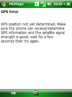
Here are the screen shots of mgmaps on my HTC and GPS error.

MODS,I was not sure how to add pics while editing the previous message, so posted a new message.

Name:  sshot000.bmp
Views: 544
Size:  225.1 KB Name:  sshot001.bmp
Views: 528
Size:  225.1 KB

Quote:
Originally Posted by rkbharat View Post
Khandelwal,

Did you tried all these steps, and what GPS device you are using?

I have HTC 3300, and I managed to install mgmaps. Downloaded Yahoo Map tiles for NCR region and working perfect.

But mgmaps is not getting GPS data from mobile. I even tried GPSPort but no use.

I am using Jbed to run the midlet on Sun J2ME. Using 1.41.03 version of mgmaps
rkbharat is offline  
Old 4th December 2008, 10:15   #659
BHPian
 
Join Date: Sep 2008
Location: Delhi
Posts: 48
Thanked: Once

@rkbharat:

I have done all the steps described in my post myself and was able to do is successfully.

I haven't used GPS functionality. My phone doesn't have GPS built in. I am using it viewing maps only.


Quote:
Originally Posted by rkbharat View Post
Khandelwal,

Did you tried all these steps, and what GPS device you are using?

I have HTC 3300, and I managed to install mgmaps. Downloaded Yahoo Map tiles for NCR region and working perfect.

But mgmaps is not getting GPS data from mobile. I even tried GPSPort but no use.

I am using Jbed to run the midlet on Sun J2ME. Using 1.41.03 version of mgmaps
Have you tried enabled/tried GPS Settings within MGmaps Menu (Menu -> GPS -> Select Device -> Internal (or GPSGate/Serial). It would be some trial and error way.

Do let us know you succeeded or not.
Khandelwal is offline  
Old 4th December 2008, 11:02   #660
Team-BHP Support
 
tsk1979's Avatar
 
Join Date: Feb 2005
Location: San Jose, CA
Posts: 23,695
Thanked: 23,484 Times

Quote:
Originally Posted by vivekiny2k View Post
I have an antiquated garmin unit (i2) ready to be retired. does anybody know if any of india maps can be loaded on it if i send back to india? it reads img files from micro sd card.

my family is from jabalpur and I really don't see any GPS data for jabalpur though.
Openstreetmap has limited maps for Jabalpur
see

OpenStreetMap

If thats enough for now, download the india.img(link in this thread itself) and use it on your garmin
tsk1979 is offline  
Reply

Most Viewed
Thread Tools Search this Thread
Search this Thread:

Advanced Search

Copyright ©2000 - 2025, Team-BHP.com
Proudly powered by E2E Networks