Quote:
Originally Posted by laluks 
We are leaving to Leh!! Hell yes!! What lies ahead? Who cares!! We will take it as it comes!! And Yes, the Swifts and Alto is going forward, no matter what!
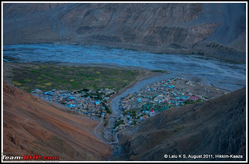
We are moving out of Kaaza.......................
|
HVK Scorpio Aug 12, Bombay-Behror, 1402 kms
Aug 13, Behror-Rampur, 692 kms
Aug 14, Rampur-Chitkul, 144 kms
Aug 15, Chitkul-Pooh, 207 kms
Aug 16, Pooh-Kaza, 178 kms
Aug 17-19, Kaza, 291 kms Aug 20, Kaza-Jispa, 236 kms
Lalu has expressed the spirits of the team as we
5 cars - my
Scorpio, JC's
Bolero, Mumbai Roadsters' 2
SWifts and the "Baby"
Alto left at 515 am from Kaza. We were emboldened by the news the previous night that the Bolero Stinger had got through to Gramphoo, and we set our destination for Keylong that night, nature willing. Never an easy task though, I knew from previous experience that some of the worst roads in the region are in the
Lahaul Valley west of the Kunzum la - total dirt track with cascading boulders in many places, following the
River Chandra all along, and with scarcely 3-5 vehicles a day sometimes, mostly the Sumo share-a-seat taxis from Manali. This entire region is closed during winter once the Kunzum la closes down.
In my mind, I was having some trepidation - a couple of days ago, my Scorpio gears mysteriously "froze" when I climbed up to 15,000 feet on the Tashi Ganga-Tiddim "new" road, something that have never happened in high altitude terrain before - and I was worried that the gears may misbehave again when we ascended to the Kunzum la, the highest pass en route.
A month ago, one of my friends had reported major water crossing problems in the Hanse nullah and I was also anxious that we 2WD vehicles should get through that too.
Even as we started driving out of Kaza, a local car guy started telling us that the road ahead was closed, which we rebutted since we had better info now that our own Bolero Stinger had got across the previous night. For a change, our information intelligence was better than theirs. When we reached the
Losar check post, the police at the check post were also surprised - and we had to inform them that the road was open!!! So much for co-ordination by various agencies working on roads in these parts. For example, Losar PWD folks know only about road till Kunzum la, and only the Chota Dara or Chhatru PWD guys knew about the condition ahead. Communication in these parts is still the old "pigeon messenger" story - information is gathered only from oncoming cars! Needless to say, there is absolutely no mobile connectivity between Kaza and Koksar or Manali region, which is a full day's journey.
We reached
Kunzum la (4560 mtres) at 900 am after having crawled up narrow dirt roads that were closed by snowfall just a few days ago. Surprisingly, I find that the altitude on the Tashi Ganga-Tiddim road was higher at 4650 mtrs!
Many of our team were seeing
snow for the time, and it was a thrilling time for all of us as we took the customary photo sheets, round around the prayer flags in Kunzum la, which separates the Lahaul and Spiti Valleys. A short break later, we were descending - lots of snow all around, and also the abandoned (?) alternative road looked as if it had taken quite a beating. Somehow, we missed the sight of some magnificent
glaciers that glisten in the mountain sides around Kunzum la.
Next turning point was at the
Batal-Chandra Tal "road" - I had fond memories of a drive to Chandra Tal 7 years ago in my Matiz. The "road" was so bad and terrifying that we christened that Ladakh trip as one of "B.C." (Before Chandra Tal) and "A.C." (After Chandra Tal), as though we were cleansed by a holy dip in the Ganga at Varanasi or a Haji! That drive was mortifying, and at the end of that drive, we saw the sign board saying "Jeepable Track" which we struck out and wrote
"Matizable Track"!!!

We had original plans to camp out in
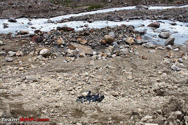
Chandra Tal, but those hopes were dashed by the prolonged "leisurely holiday" in Kaza. Nevertheless, we were tempted to check out the road. We could see a Qualis parked nearby indicating that the trekkers must have walked the 14-odd kms from there to the water's edge. I told the other 4 cars to remain behind while my Scorpio - with TS and Lalu on board - decided to take a reccee on the "road" to see how far we could go. Predicatably, it was narrow - steep fall on one side and in places the soil had crumbled and we had just enough space to manouevre the Scorpio, even as we waded through 2-3 water crossings. Gradients are steep on this road and if you are unlucky to stall on any of the steep slopes in a 2WD car, you may have to back up till you find a level ground in order to get the traction to complete the climb. Luckily, there was no evidence of the snow, but there were plenty of stones and boulders on the road. There was this Italian (?) mobiker who shrugged when we asked him if he had managed to get through. We drove 7 kms on this 14-km road before we reached a point where a outcrop rock impeded our passage further. We had to regretfully call off the drive there, even as we could see the River Chandra appearing round the corner from the Lake.
Turn back? How? We were in a road hardly the width of the Scorpio and on a steep slope. It took me some 12-15 turn manouvres - with Lalu sweating it out as the "spotter" to ensure the front wheels did not go off the cliff - but we managed to turn it around and be on our way back to Batal. I guess Chandra Tal will be another day.
We rejoined the rest of the team and came down to the
Batal dhaaba. The Batal dhaaba - and the
Batal "chacha" who runs it - are well-known to any motorist in this region.
It is like a beacon, the "chacha" is the saviour for many stranded in landslides. This dhaba hut apparently can house 30-40 people. It was just recovering from one such situation when some 60-80 stranded trekkers and motorists were marooned here for 2-3 days even as they were cut off by land slides on both sides - towards Chota Dara as well as towards Kunzum la. Wow, this dhaba has a
"satellite" telephone number here, 08991722020 - you can call up to find out the condition of this difficult Lahaul Valley sector which is tormented by landslides often. Chai and Maggi were welcome, as we stayed there 30 minutes till 1130 am.....
It was to be a long day, so this is going to be a long post.....to be continued
All photos are from the albums of our team members like TS, VE and JP. 

 17th October 2011, 11:37

 (2)
Thanks
(2)
Thanks